Selwyn District

Last updated
Selwyn District
TranzAlpine train trip - panoramio - Maksym Kozlenko (16).jpg
Photo taken from the TranzAlpine train
Selwyn DC.PNG
Location of the Selwyn District within the South Island
Coordinates: 43°34′34″S172°03′36″E / 43.576°S 172.06°E / -43.576; 172.06 Coordinates: 43°34′34″S172°03′36″E / 43.576°S 172.06°E / -43.576; 172.06
Country New Zealand
Region Canterbury
Wards
  • Ellesmere
  • Malvern
  • Selwyn Central
  • Springs
Formed1989
Seat Rolleston
Government
  Mayor Sam Broughton
  Deputy MayorMalcolm Lyall
   Territorial authority Selwyn District Council
Area
[1]
  Total6,381.15 km2 (2,463.78 sq mi)
Population
 (June 2022) [2]
  Total79,300
  Density12/km2 (32/sq mi)
Time zone UTC+12 (NZST)
  Summer (DST) UTC+13 (NZDT)
Postcode(s)
Website www.selwyn.govt.nz OOjs UI icon edit-ltr-progressive.svg

Selwyn District is a predominantly rural district in central Canterbury, on the east coast of New Zealand's South Island. It is named after the Selwyn River / Waikirikiri, which is in turn named after Bishop George Selwyn, the first Anglican bishop of New Zealand who, in 1843 and 1844, travelled the length of the country by horse, foot, boat and canoe, leaving in his wake a sprinkling of locations that now bear his name.

Contents

History

The first inhabitants of the area were the Māori who first settled New Zealand from the Cook and Society Islands about 700 years ago. The predominant Māori tribe today, in Selwyn and most of the rest of the South Island, is Ngāi Tahu, whose local marae (meeting house) is at Taumutu near the exit of Lake Ellesmere (Te Waihora).

In the late 19th century, European (chiefly British) colonists arrived and carved the area up into farmland. This has remained the predominant pattern ever since.

The Selwyn District as a unit of government was formed in the 1989 local government reforms from a legislated merger of the Malvern and Ellesmere counties, along with a portion of Paparua County. [3]

Since this time, the district has enjoyed a stable and prosperous existence. Recent years have seen above-average population growth, making it the fastest-growing local authority in New Zealand in 2013.

Most of Selwyn's new residents have moved from Christchurch to settle on small "lifestyle" farms and in Selwyn's small towns which are within easy commuting distance of the city (e.g. Rolleston, Prebbleton, Lincoln, West Melton, Kirwee). Rolleston is the largest town in Selwyn.

Selwyn District, along with Christchurch and Waimakariri District, experienced some damage in the 2010 Canterbury earthquake. The earthquake epicentre was located just outside Darfield.

Government

The district is governed by an elected mayor and a council of 11 members, elected simultaneously every 3 years. The current mayor is Sam Broughton, who was first elected mayor in October 2016. [4]

The mayor is elected on a First Past the Post basis.

The 10 councillors are elected from four wards on a multi-member First Past the Post basis; the total number of votes a candidate receives are considered:

a.) 2 councillors are elected from Ellesmere Ward
b.) 2 councillors are elected from Malvern Ward
c.) 3 councillors are elected from Rolleston Ward
d.) 3 councillors are elected from Springs Ward

The Malvern Ward also has a Community Board, which has power delegated to it by the Council.

The Selwyn district is within the Canterbury Region so Canterbury Regional Council has responsibilities for regional planning, and water, air, discharge and river bed resource consents.

The Selwyn district has powers delegated to it by the Government of New Zealand, and carries out its duties regarding laws such as the Local Government Act 2002 and the Resource Management Act 1991.

In national politics, Selwyn is represented in the Selwyn electorate. Nicola Grigg of the National Party is the incumbent MP.

Geography

The Selwyn District lies in central Canterbury, and occupies a central position in the South Island.

Boundaries: On the Canterbury Plains, the Waimakariri River forms the northern boundary; in the hill country the border with the Hurunui District is more arbitrary. The eastern boundary comprises (from north to south) the city of Christchurch, Banks Peninsula, and the South Pacific Ocean. The southern boundary is the Rakaia River, beyond which lies Ashburton District. The western boundary is the main divide of the Southern Alps.

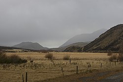
Geographical features: Selwyn District contains within it two distinct regions: the plains and the high country. The plains, where most of the population lives and the majority of activity takes place, form an expanse of low-lying, flat, and comparatively dry grassland. The extreme south-east is dominated by Lake Ellesmere / Te Waihora, an expanse of water surrounded by marshes, formed by the out-flow of the Selwyn River / Waikirikiri. The tributaries of the Selwyn River include the Waianiwaniwa River, the Hororata River and the Hawkins River.

The high country is a sparsely-populated region, mainly consisting of hill and mountain ranges and narrow river valleys. Most of the high country is grassland, including some tussocklands; areas of beech forest remain within the Craigieburn Forest Park and the Arthur's Pass National Park.

Climate: The plains have a temperate climate, characterised by warm, dry summers and cool winters. The Southern Alps are responsible for the relatively low rainfall, and also lead to a foehn wind, the "Canterbury Nor'Wester". This strong, hot and dry wind is most common in spring and summer, and on occasion reaches damage-causing strength. In the mountain country of the Southern Alps, conditions are much colder and wetter.

Demographics

Selwyn District covers 6,381.15 km2 (2,463.78 sq mi) [1] and had an estimated population of 79,300 as of June 2022, [2] with a population density of 12.4 people per km2.

Historical population
YearPop.±% p.a.
200633,645    
201344,595+4.11%
201860,561+6.31%
Source: [5]

Selwyn District had a population of 60,561 at the 2018 New Zealand census, an increase of 15,966 people (35.8%) since the 2013 census, and an increase of 26,916 people (80.0%) since the 2006 census. There were 20,631 households. There were 30,591 males and 29,970 females, giving a sex ratio of 1.02 males per female. The median age was 37.6 years (compared with 37.4 years nationally), with 13,452 people (22.2%) aged under 15 years, 10,833 (17.9%) aged 15 to 29, 29,301 (48.4%) aged 30 to 64, and 6,975 (11.5%) aged 65 or older.

Ethnicities were 89.3% European/Pākehā, 7.9% Māori, 1.7% Pacific peoples, 6.4% Asian, and 2.6% other ethnicities. People may identify with more than one ethnicity.

The percentage of people born overseas was 19.7, compared with 27.1% nationally.

Although some people objected to giving their religion, 55.2% had no religion, 35.2% were Christian, 0.6% were Hindu, 0.4% were Muslim, 0.5% were Buddhist and 1.9% had other religions.

Of those at least 15 years old, 10,305 (21.9%) people had a bachelor or higher degree, and 6,930 (14.7%) people had no formal qualifications. The median income was $42,700, compared with $31,800 nationally. 11,577 people (24.6%) earned over $70,000 compared to 17.2% nationally. The employment status of those at least 15 was that 27,345 (58.0%) people were employed full-time, 7,806 (16.6%) were part-time, and 1,053 (2.2%) were unemployed. [5]

Individual wards
NameArea (km2)PopulationDensity (per km2)HouseholdsMedian ageMedian income
Malvern Ward4,915.258,6131.753,31841.7 years$37,600
Selwyn Central Ward295.7425,50386.238,29536.1 years$46,400
Ellesmere Ward868.148,91610.273,14134.2 years$42,500
Springs Ward302.0217,53558.065,87740.1 years$40,300
New Zealand37.4 years$31,800

Urban areas

The Selwyn District has six towns with a population over 1,000. Together they are home to 63.9% of the district's population. [2]

Urban area Population

(June 2022) [2]

% of district
Rolleston 28,00035.3%
Lincoln 9,18011.6%
Prebbleton 5,2606.6%
Darfield 3,1203.9%
West Melton 2,6403.3%
Leeston 2,4903.1%

Economy

Much of the district's economy is based around farming. Most of this is pastoral: beef cattle and sheep in drier areas, and dairy and deer farming in wetter areas. Some horsebreeding is also done. There is also a substantial amount of cropping; wheat and barley are grown on the plains, along with smaller amounts of grapes and other fruit, vegetables, mushrooms and flowers.

Selwyn District experienced the strongest economic growth of any district in New Zealand in 2012, with employment growing by 9.5%, compared to the national average of 1%. 1,200 new jobs were created in the district in 2012.

The services in the small towns primarily serve the surrounding community. The major exception is the town of Lincoln, home to a University and a number of Crown Research Institutes and other organisations concerned with scientific research. Rolleston is also home to IZONE – New Zealand's largest business park.

The Selwyn District Council owns 11% shareholding in Orion, the local electricity distribution company.

Related Research Articles

<span class="mw-page-title-main">Marlborough District</span> District and unitary authority of New Zealand

Marlborough District or the Marlborough Region, commonly known simply as Marlborough, is one of the 16 regions of New Zealand, located on the northeast of the South Island. Marlborough is a unitary authority, both a district and a region. Marlborough District Council is based at Blenheim, the largest town. The unitary region has a population of 51,900.

<span class="mw-page-title-main">Lincoln, New Zealand</span> Town in Canterbury, New Zealand

Lincoln is a town in the Selwyn District, in the Canterbury Region of New Zealand's South Island. The town is located on the Canterbury Plains to the west of Banks Peninsula, 22 kilometres southwest of Christchurch. The town has a population of 9,180, making it the second largest town in the Selwyn District behind nearby Rolleston.

<span class="mw-page-title-main">Southland District</span> Territorial authority district in Southland Region, New Zealand

Southland District is a territorial authority district in New Zealand that covers the south of the South Island as well as Stewart Island/Rakiura.

<span class="mw-page-title-main">Lake Ellesmere / Te Waihora</span> Lagoon in New Zealand

Lake Ellesmere / Te Waihora is a broad, shallow coastal lake or waituna, in the Canterbury region of the South Island of New Zealand. It is directly to the west of Banks Peninsula, separated from the Pacific Ocean by the long, narrow, sandy Kaitorete Spit, or more correctly Kaitorete Barrier. It lies partially in extreme southeastern Selwyn District and partially in the southwestern extension of the former Banks Peninsula District, which now is a ward in the city of Christchurch. The lake holds high historical and cultural significance to the indigenous Māori population and the traditional Māori name Te Waihora, means spreading waters. It has officially had a dual English/Māori name since at least 1938.

Selwyn is a village in the Selwyn District of Canterbury, New Zealand. It was laid out in the 1860s for a population of 2,000 people, but it currently has very few houses.

<span class="mw-page-title-main">Selwyn River</span> River in New Zealand

The Selwyn River flows through the Selwyn District of Canterbury in the South Island of New Zealand.

<span class="mw-page-title-main">Manawatū District</span> Territorial authority district in Manawatū-Whanganui, New Zealand

Manawatū District is a territorial authority district in the Manawatū-Whanganui local government region in the North Island of New Zealand, administered by Manawatū District Council. It includes most of the area between the Manawatū River in the south and the Rangitīkei River in the north, stretching from slightly south of the settlement of Himatangi in the south, to just south of Mangaweka in the north, and from the Rangitīkei River to the top of the Ruahine Range in the east. It does not include the Foxton area and the mouth of the Manawatū River, or Palmerston North City. Its main town is Feilding. The district has an area of 2,624 km².

<span class="mw-page-title-main">Leeston</span> Town in South Island, New Zealand

Leeston is a town on the Canterbury Plains in the South Island of New Zealand. It is located 30 kilometres southwest of Christchurch, between the shore of Lake Ellesmere / Te Waihora and the mouth of the Rakaia River. The town is home to a growing number of services which have increased and diversified along with the population. Leeston has a supermarket, schools, churches, hospital, gym, cafes, restaurants, medical centre, pharmacy and post office. The Selwyn District Council currently has a service office in Leeston, after the headquarters was shifted to Rolleston.

<span class="mw-page-title-main">Rangitikei District</span> Territorial authority district in Manawatū-Whanganui, New Zealand

The Rangitikei District is a territorial authority district located primarily in the Manawatū-Whanganui region in the North Island of New Zealand, although a small part, the town of Ngamatea, lies in the Hawke's Bay Region. It is located in the southwest of the island, and follows the catchment area of the Rangitīkei River.

<span class="mw-page-title-main">Westland District</span> Territorial authority district in West Coast, New Zealand

Westland District is a territorial authority district on the West Coast of New Zealand's South Island. It is administered by the Westland District Council. The district's population is 8,820.

<span class="mw-page-title-main">Rolleston, New Zealand</span> Town in the South Island of New Zealand

Rolleston is the seat and largest town in the Selwyn District, in the Canterbury region of New Zealand's South Island. It is located on the Canterbury Plains 22 kilometres (14 mi) south-west of Christchurch, and is part of the wider Christchurch metropolitan area. The town has a population of 28,000, making it New Zealand's 24th-largest urban area and the third-largest in Canterbury. It was nicknamed the "Town of the Future" in the 1970s by Prime Minister Norman Kirk. The "Town of the Future" signage has since been removed from the entrances to Rolleston.

<span class="mw-page-title-main">Rangitikei District Council</span>

The Rangitikei District Council is the local government authority for Rangitikei District in New Zealand. It is a territorial authority elected to represent the 16,100 people of Rangitikei. Since October 2013, the Mayor of Rangitikei is Andy Watson, who succeeded Robert "Chalky" Leary. The council consists of a mayor who is elected at large, and 11 councillors elected across three wards, one of whom gets chosen as deputy mayor. There are also two community boards – for Rātana and Taihape. The councillors are elected under the first-past-the-post (FPTP) system in triennial elections.

<span class="mw-page-title-main">L II River</span> River in New Zealand

The L II River is a small spring-fed river in Canterbury, New Zealand. It rises near Lincoln and flows through very flat farmland, mostly fed by land drainage ditches before emptying into Lake Ellesmere / Te Waihora just east of the mouth of the Selwyn River / Waikirikiri.

Selwyn District Council is the territorial authority for the Selwyn District of New Zealand. The council was formed in 1989. A Selwyn County Council previously operated in the area between 1876 and 1910.

Ellesmere was a parliamentary electorate in the Canterbury region of New Zealand. It existed for two periods between 1861 and 1928 and was represented by six Members of Parliament.

<span class="mw-page-title-main">Gore District, New Zealand</span> Territorial authority district in Southland, New Zealand

Gore District is a district in the Southland region of the South Island of New Zealand.

<span class="mw-page-title-main">Ashburton District</span> Territorial authority district in Canterbury, New Zealand

Ashburton District is a territorial authority district in the Canterbury Region of the South Island of New Zealand. It encompasses the town of Ashburton, a number of small towns and settlements and the surrounding rural area, roughly coterminous with Mid Canterbury. The district had a population of 36,300 as of June 2022.

<span class="mw-page-title-main">Waimate District</span> Territorial authority district in Canterbury Region, New Zealand

Waimate District is a territorial authority district located in the Canterbury Region of the South Island of New Zealand. The main town is Waimate, while there are many smaller rural communities dispersed throughout the area. Its boundary to the south is the Waitaki River, to the west Lake Benmore and to the north-east the Pareora River.

<span class="mw-page-title-main">Hutt City Council</span> Territorial authority in the Wellington urban area of New Zealand

The Hutt City Council is a territorial authority in New Zealand, governing the city of Lower Hutt. Lower Hutt is the country's seventh largest city. The city borders Porirua to the north, Upper Hutt to the northeast, South Wairarapa District to the east, and Wellington to the southwest and west. It is one of nine territorial authorities in the Wellington Region.

Ellesmere is a locality in the Selwyn District of New Zealand.

References

  1. 1 2 "ArcGIS Web Application". statsnz.maps.arcgis.com. Retrieved 12 March 2022.
  2. 1 2 3 4 "Subnational population estimates (RC, SA2), by age and sex, at 30 June 1996-2022 (2022 boundaries)". Statistics New Zealand . Retrieved 25 October 2022. (regional councils); "Subnational population estimates (TA, SA2), by age and sex, at 30 June 1996-2022 (2022 boundaries)". Statistics New Zealand . Retrieved 25 October 2022. (territorial authorities); "Subnational population estimates (urban rural), by age and sex, at 30 June 1996-2022 (2022 boundaries)". Statistics New Zealand . Retrieved 25 October 2022. (urban areas)
  3. "Brief History of Selwyn Local Government". Selwyn District Council. Retrieved 30 September 2016.
  4. "Selwyn District Council - Mayor and Council". Selwyn.govt.nz. Retrieved 17 April 2023.
  5. 1 2 "Statistical area 1 dataset for 2018 Census". Statistics New Zealand. March 2020. Selwyn District (062). 2018 Census place summary: Selwyn District