Oxford Terrace Baptist Church

Last updated

Oxford Terrace Baptist Church
Oxford Terrace Baptist Church, Christchurch, New Zealand.jpg
Oxford Terrace Baptist Church in 2020
Oxford Terrace Baptist Church
43°31′38″S172°38′35″E / 43.5273°S 172.6430°E / -43.5273; 172.6430
Address286 Oxford Terrace, Christchurch Central City, Christchurch
CountryNew Zealand
Denomination Baptist
Associations Baptist Churches of New Zealand
Website otbc.org.nz
History
Status Church
Architecture
Functional statusActive
Architectural type Church
Style Modernist
Completed24 December 2017
Construction costNZ$8.5 million
Specifications
Capacity250 people
Oxford Terrace Baptist Church (former)
25 Feb 2011 Oxford Tce Baptist Church.jpg
The building after the collapse caused by the February 2011 Christchurch earthquake
Oxford Terrace Baptist Church
43°31′38″S172°38′35″E / 43.5273°S 172.6430°E / -43.5273; 172.6430
CountryNew Zealand
Previous denomination Baptist
History
StatusChurch (1882 2010)
Events
Architecture
Functional statusBuilding collapsed
Architect(s) Edward J. Saunders
Architectural type Church
Style Neoclassical style
Completed9 July 1882
Construction cost NZ£3,130
Closed4 September 2010
Demolished22 February 2011
Specifications
Capacity600 people
Official nameOxford Terrace Baptist Church
Designated10 September 2004
DelistedJune 2011
Reference no.1853

Oxford Terrace Baptist Church is a Baptist church located in the Christchurch Central City on a prominent corner property fronting the Avon River. It is affiliated with the Baptist Churches of New Zealand.

Contents

The original building was significantly damaged in the 2010 Canterbury earthquake and collapsed in the subsequent February 2011 Christchurch earthquake. This building had a Category II listing by the New Zealand Historic Places Trust. A new building was opened on Christmas Eve 2017.

History

The Christchurch Baptist congregation was founded in 1863 by 19 settlers from England. Decimus Dolamore, who was instrumental for establishing the Baptist faith in New Zealand, was the first minister. [1] The congregation first met in the town hall in High Street. In 1864, a church was built in Lichfield Street opposite where the Bus Exchange is located (as of 2011). The congregation split in 1867, but reunited in 1870 and built a church in Hereford Street. [1] The congregation decided to build larger premises and purchased land for £1,325 on the corner of Oxford Terrace and Madras Street, overlooking the Avon River. [2]

Demolished church building

A design competition was won by local architect Edward J. Saunders. The congregation decided, though, that the total costs of the project was beyond their means. As an interim measure, the Hereford Street church was transported to the new site. Much public amusement was caused when the church sat on a wagon next to ChristChurch Cathedral for a weekend in 1879. Three weeks after arriving at the new site, the building was damaged by fire, but opened again some months later. [2] The older building was in use until 1903, when it once again caught fire. [3]

Tenders for the new church were called for in August 1881, but the prices submitted were too high, ranging from £3,956 to £5,337. [3] A revised tender in September 1881 received a quote of £3,130 by Morey and McHale, which was accepted. The Reverend C. Dallaston laid the foundation stone on 14 October 1881 and the project was completed and opened to the public on 9 July 1882. At that point, it was the largest Baptist church in the country. [2] An organ was imported from England and installed in 1915. [1]

The main building was significantly damaged in the 4 September 2010 earthquake [4] and collapsed in the subsequent 22 February 2011 earthquake. It was demolished in late June 2011 following further collapse in the 13 June 2011 earthquake.

Heritage listing

On 10 September 2004, the church was registered by the New Zealand Historic Places Trust as a Category II historic place, with the registration number being 1853. It is significant for its Neoclassical architecture, which is unusual for Christchurch. The church had the last remaining temple frontage in the city. [2]

In 2011, Peter Beck, the dean of ChristChurch Cathedral, listed the Oxford Terrace Baptist Church as one of the "iconic churches of the city". [5]

Following the 2011 Christchurch earthquakes, the building was removed form the heritage list and categorised as Lost Heritage. [6]

Current church building

The former site of the church of the church was used for a temporary art installation by Peter Majendie, unveiled at the first anniversary of the February 2011 earthquake. The installation, called Reflection of Loss of Lives, Livelihoods and Living in Neighbourhood, used 185 chairs all painted in white but of different shapes, reflecting the different personalities of those who died. [7] The artwork became known as 185 empty chairs . Within a year, the installation moved to a different site, and in 2017, discussions started to make the artwork permanent. [8]

In March 2016, The Press revealed that a modern replacement church had gained resource consent. The NZ$8.5 million project will create a two-storey building with an auditorium for 250 people; NZ$1.5 million has yet to be fund-raised. The church was reopened on Christmas Eve 2017. [9]

Related Research Articles

<span class="mw-page-title-main">ChristChurch Cathedral</span> Church in Christchurch Central City, New Zealand

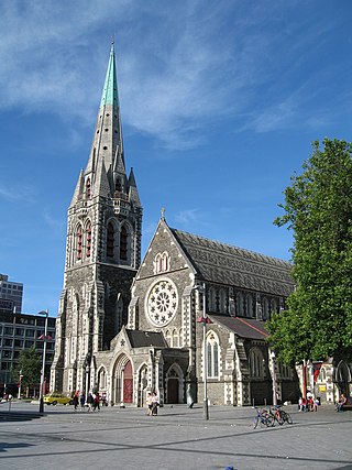
ChristChurch Cathedral, also called Christ Church Cathedral and (rarely) Cathedral Church of Christ, is a deconsecrated Anglican cathedral in the city of Christchurch, New Zealand. It was built between 1864 and 1904 in the centre of the city, surrounded by Cathedral Square. It became the cathedral seat of the Bishop of Christchurch, who is in the New Zealand tikanga of the Anglican Church in Aotearoa, New Zealand and Polynesia.

<span class="mw-page-title-main">Christchurch Arts Centre</span> Arts, culture, education, creativity and entrepreneurship in Christchurch, New Zealand

TheArts Centre Te Matatiki Toi Ora is a hub for arts, culture, education, creativity and entrepreneurship in Christchurch, New Zealand. It is located in the Gothic Revival former Canterbury College, Christchurch Boys' High School and Christchurch Girls' High School buildings, many of which were designed by Benjamin Mountfort. The centre is a national landmark and taonga as it is home to New Zealand's largest collection of category one heritage buildings with 21 of the 23 buildings covered by Heritage New Zealand listings.

<span class="mw-page-title-main">Christchurch City Libraries</span> Library system for Christchurch, New Zealand

Christchurch City Libraries is a network of 21 libraries and a mobile book bus. operated by the Christchurch City Council and Following the 2011 Christchurch earthquake the previous Christchurch Central Library building was demolished, and was replaced by a new central library building in Cathedral Square, Tūranga, which opened in 2018. A number of community libraries were also rebuilt post earthquake.

<span class="mw-page-title-main">Christchurch Central City</span> Central area of Christchurch, New Zealand

Christchurch Central City or Christchurch City Centre is the geographical centre and the heart of Christchurch, New Zealand. It is defined as the area within the Four Avenues and thus includes the densely built up central city, some less dense surrounding areas of residential, educational and industrial usage, and green space including Hagley Park, the Christchurch Botanic Gardens and the Barbadoes Street Cemetery.

<span class="mw-page-title-main">John Anderson (mayor)</span> New Zealand blacksmith and businessman (1820–1897)

John Anderson was the second Mayor of Christchurch in New Zealand 1868–1869, and a successful businessman. He had a close connection with three buildings that have later received Category I heritage registrations by Heritage New Zealand. Two of these buildings were demolished following the February 2011 Christchurch earthquake.

<span class="mw-page-title-main">Colombo Street</span> Main road in Christchurch, New Zealand

Colombo Street is a main road of the city of Christchurch, New Zealand. It runs south-north through the centre of Christchurch with a break at Cathedral Square. As with many other central Christchurch streets, it is named for a colonial Anglican bishopric, Colombo, Sri Lanka in what at the time was known as Ceylon. Parts of the street which run through Sydenham were known as Addison Street during the 1880s, and some parts were known as Colombo Road.

<span class="mw-page-title-main">Durham Street Methodist Church</span> Church in Christchurch Central City, New Zealand

The Durham Street Methodist Church was a former heritage-listed Methodist church located in Christchurch, New Zealand. Built in 1864 in the Gothic Revival style, it was, prior to its destruction, the earliest stone church constructed in the Canterbury region.

<span class="mw-page-title-main">Clarendon Tower</span> Former building in Christchurch, NZ

Clarendon Tower was a high rise building on Worcester Street at Oxford Terrace in the Christchurch Central City, New Zealand. Built on the site of the former Clarendon Hotel, the façade of the historic building was kept in the redevelopment and was protected by the New Zealand Historic Places Trust as a Category II heritage structure. Following damage from the February 2011 Christchurch earthquake, the 17-storey building has been demolished.

<span class="mw-page-title-main">St Paul's Church, Christchurch</span> Church in New Zealand

St Paul's Church was a heritage-listed former Presbyterian church in Cashel Street, Christchurch. Built in 1877, the church was registered by the New Zealand Historic Places Trust as a Category I heritage building. Following the February 2011 Christchurch earthquake, the building was removed from the heritage list and demolished.

<span class="mw-page-title-main">Church of St Michael and All Angels, Christchurch</span> Church in Christchurch Central City, New Zealand

The Church of St Michael and All Angels is an Anglican church located at 84 Oxford Terrace, Christchurch, New Zealand.

<span class="mw-page-title-main">City Mall, Christchurch</span> Street in Christchurch Central City, New Zealand

City Mall is the main pedestrian mall in the central city of Christchurch, New Zealand, comprising two sections of Cashel Street plus the Bridge of Remembrance and one section of High Street. It is also known colloquially as Cashel Mall. The Bridge of Remembrance was pedestrianised in 1976. The main mall was closed to traffic on 11 January 1982 and formally reopened as a pedestrian mall on 7 August, but it was not until 1992 that the entire mall was paved. The mall was redeveloped between 2006 and 2009, and track was installed for an expansion of the heritage tram network.

<span class="mw-page-title-main">St Saviour's Chapel</span> Church in Lyttelton, New Zealand

St Saviour's at Holy Trinity is an Anglican church in Lyttelton, Christchurch, New Zealand. St Saviour's Chapel was relocated from West Lyttelton to Christchurch's Cathedral Grammar School in the 1970s. Following the earthquakes and the demolition of Holy Trinity Church, Lyttelton, St Saviour's was returned to Lyttelton to the site of Holy Trinity in 2013.

<span class="mw-page-title-main">St Luke's Church, Christchurch</span> Church in Christchurch, New Zealand

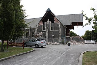
St Luke's Church was an Anglican church located in Christchurch, New Zealand. The former church was built on one of the five sites set aside in the central city in the original survey of Christchurch for the Anglican church and the building was registered as a Category II historic place with the New Zealand Historic Places Trust. Following sustained damage caused by the February 2011 Christchurch earthquake, the building was demolished in July 2011.

<span class="mw-page-title-main">The Octagon, Christchurch</span> Restaurant in Christchurch, New Zealand

TheTrinity Church or Trinity Congregational Church designed by Benjamin Mountfort, later called the State Trinity Centre, is a Category I heritage building listed with Heritage New Zealand. Damaged in the 2010 Canterbury earthquake and red-stickered after the February 2011 Christchurch earthquake, the building was threatened with demolition like most other central city heritage buildings. In June 2012, it was announced that the building would be saved, repaired and earthquake strengthened. The building, post its church status, has housed some commercial operations, including the State Trinity Centre; 'The Octagon' (2006-2010); and later, following earthquake repairs, a business called 'The Church Brew Pub' (2023-).

<span class="mw-page-title-main">Christchurch Central Library</span> Library in Christchurch Central City

The Canterbury Public Library building, was a library in Central Christchurch and the main library of Christchurch City Libraries, New Zealand. It was the largest library in the South Island and the third-biggest in New Zealand. It was also known as the Central Library. It opened in 1982 on the corner of Oxford Terrace and Gloucester Street but was closed on the day of the 22 February 2011 Christchurch earthquake. After the earthquake temporary libraries to serve the Cental City were set up at South City Mall, Tuam Street, Manchester Street and Peterborough Street. The building was demolished in 2014 to make way for the Convention Centre Precinct. Tūranga, the replacement library, and Civic Space was opened in 2018.

<i>185 empty chairs</i> Memorial in Christchurch, New Zealand

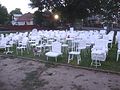
185 empty chairs, also known as 185 white chairs or 185 empty white chairs or simply as 185 chairs, is an unofficial memorial for the 185 individuals who died in the 2011 Christchurch earthquake. Envisaged as a short-term installation made from chairs painted white, it became a major tourist attraction in Christchurch, New Zealand. Installed at the day of the earthquake's first anniversary, it preceded the official earthquake memorial—the Canterbury Earthquake National Memorial—by five years. As of 2017, there was a desire to turn the temporary installation into a permanent fixture. The memorial was closed and the chairs dispersed in April 2023.

<span class="mw-page-title-main">Latimer Square</span>

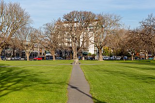
Latimer Square is an urban park in central Christchurch, New Zealand. It is located 400 metres (440 yd) east of the city's centre, Cathedral Square. Many commemorative events take place in Latimer Square. The square lies between the major urban thoroughfares of Gloucester Street and Worcester Street. Madras Street runs north and south to Latimer Square. The square is grassed and crossed by concrete paths and edged by mature trees. It covers an area of a little over 1.8 hectares.

<span class="mw-page-title-main">Worcester Street, Christchurch</span> Street in Christchurch, New Zealand

Worcester Street is a road in the central city of Christchurch, New Zealand. It runs from the intersection of Rolleston Avenue in the west, and terminates in the east at the intersection of Woodham Road in Linwood. Between Rolleston Avenue and Cambridge Terrace, it is known as Worcester Boulevard.

References

  1. 1 2 3 "About us". Oxford Terrace Baptist Church. Retrieved 19 March 2011.
  2. 1 2 3 4 Wilson, Pam. "Oxford Terrace Baptist Church". New Zealand Historic Places Trust. Retrieved 19 March 2011.
  3. 1 2 "Baptist Church, Oxford Terrace, Christchurch". Christchurch City Libraries. Retrieved 19 March 2011.
  4. van Beynen, Martin (5 September 2010). "Quake devastates Christchurch's heritage". The Press. Retrieved 19 March 2011.
  5. van Beynen, Martin (8 March 2011). "Brit's $4m gift to cathedral earthquake fund". The Press. Retrieved 19 March 2011.
  6. "Lost Heritage: Canterbury earthquakes: Christchurch I to P". Heritage New Zealand . 2011. Retrieved 15 October 2023.
  7. "Installation represents victims' personalities". The Press. 23 February 2012. Retrieved 2 March 2012.
  8. Matthews, Philip (1 July 2017). "Remembering loss and thinking ahead". The Press . pp. C1–C2. Retrieved 4 July 2017.
  9. Lochhead, Ian (18 February 2020). "Church in the village". Architecture Now. Retrieved 4 August 2020.

Commons-logo.svg Media related to Old Oxford Terrace Baptist Church at Wikimedia Commons