
Christchurch is the largest city in the South Island and the second-largest city by urban area population in New Zealand. Christchurch has a population of 396,200 and is located in the Canterbury Region, near the centre of the east coast of the South Island, east of the Canterbury Plains. It is located near the southern end of Pegasus Bay, and is bounded to the east by the Pacific Ocean and to the south by the ancient volcanic complex of the Banks Peninsula. The Avon River (Ōtākoro) winds through the centre of the city, with a large urban park along its banks. With the exception of the Port Hills, it is a relatively flat city, on an average around 20 m (66 ft) above sea level. Christchurch has a reputation for being an English city, with its architectural identity and nickname the 'Garden City' due to similarities with garden cities in England. Christchurch has a temperate oceanic climate with regular moderate rainfall.

Rangiora is the largest town and seat of the Waimakariri District, in Canterbury, New Zealand. It is 29 kilometres (18 mi) north of Christchurch, and is part of the Christchurch metropolitan area. With an estimated population of 19,600, Rangiora is the 30th largest urban area in New Zealand, and the fifth-largest in the Canterbury region.
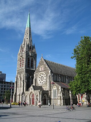
ChristChurch Cathedral, also called Christ Church Cathedral and (rarely) Cathedral Church of Christ, is a deconsecrated Anglican cathedral in the city of Christchurch, New Zealand. It was built between 1864 and 1904 in the centre of the city, surrounded by Cathedral Square. It became the cathedral seat of the Bishop of Christchurch, who is in the New Zealand tikanga of the Anglican Church in Aotearoa, New Zealand and Polynesia.
Riccarton is a suburb of Christchurch. It is due west of the city centre, separated from it by Hagley Park. Upper Riccarton is to the west of Riccarton.
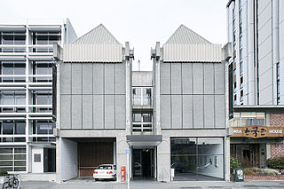
Centre of Contemporary Art is a curated art gallery in the centre of Christchurch, New Zealand. The gallery is governed by the Canterbury Society of Arts Charitable Trust.

Christchurch Central City or Christchurch City Centre is the geographical centre and the heart of Christchurch, New Zealand. It is defined as the area within the Four Avenues and thus includes the densely built up central city, some less dense surrounding areas of residential, educational and industrial usage, and green space including Hagley Park, the Christchurch Botanic Gardens and the Barbadoes Street Cemetery.

The Hotel Grand Chancellor was a major four-star hotel in the centre of Christchurch in New Zealand, one of eleven Hotel Grand Chancellor establishments across Australia and New Zealand. The hotel was located at 161 Cashel Street, close to the city's City Mall central shopping precinct.
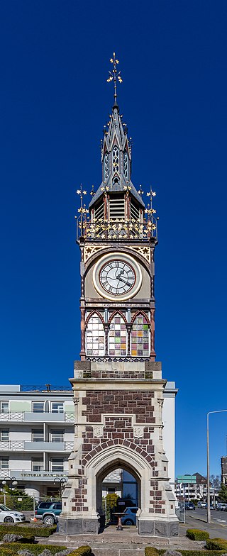
The Victoria Clock Tower, also known as the Diamond Jubilee Clock Tower, is a heritage-registered clock tower located in Christchurch, New Zealand. Designed by Benjamin Mountfort, it is registered as a "Historic Place – Category I" by the New Zealand Historic Places Trust.

The Chief Post Office or Christchurch Central Post Office, originally known as the Government Buildings, is located in Cathedral Square, Christchurch, New Zealand. The building was initially a post office with Immigration, Customs and Public Works departments. The Government Buildings were later replaced by the new Government Buildings opened in 1913, and the Chief Post Office remained on-site. In 1881, New Zealand’s first telephone exchange was installed in the building. Post services were offered from the building until 2000 when it was re-purposed to house a Christchurch tourist information centre and a restaurant, café and offices. Following the 2011 Christchurch earthquake the building closed. In the early 2020s repairs and strengthening took place. The building was planned to reopen in 2023 in stages, and eventually include a restaurant, shops, and a visitor information centre, under the name "The Grand". The structure is registered with Heritage New Zealand as a Category I heritage building.

The Dux de Lux, originally called Llanmaes, was a popular beer garden and restaurant in Christchurch, New Zealand, that was part of the Arts Centre.

City Mall is the main pedestrian mall in the central city of Christchurch, New Zealand, comprising two sections of Cashel Street plus the Bridge of Remembrance and one section of High Street. It is also known colloquially as Cashel Mall. The Bridge of Remembrance was pedestrianised in 1976. The main mall was closed to traffic on 11 January 1982 and formally reopened as a pedestrian mall on 7 August, but it was not until 1992 that the entire mall was paved. The mall was redeveloped between 2006 and 2009, and track was installed for an expansion of the heritage tram network.

TheTrinity Church or Trinity Congregational Church designed by Benjamin Mountfort, later called the State Trinity Centre, is a Category I heritage building listed with Heritage New Zealand. Damaged in the 2010 Canterbury earthquake and red-stickered after the February 2011 Christchurch earthquake, the building was threatened with demolition like most other central city heritage buildings. In June 2012, it was announced that the building would be saved, repaired and earthquake strengthened. The building, post its church status, has housed some commercial operations, including the State Trinity Centre; 'The Octagon' (2006–2010); and later, following earthquake repairs, a business called 'The Church Brew Pub' (2023–present).

The Westpac Canterbury Centre was a landmark tower on the corner of High Street and Cashel Street in the center of Christchurch, New Zealand. In the early 2010s, it was considered the 9th tallest building in Christchurch, standing at 55 metres tall with 13-storeys and a basement level.

The Canterbury Public Library building, was a library in Central Christchurch and the main library of Christchurch City Libraries, New Zealand. It was the largest library in the South Island and the third-biggest in New Zealand. It was also known as the Central Library. It opened in 1982 on the corner of Oxford Terrace and Gloucester Street but was closed on the day of the 22 February 2011 Christchurch earthquake. After the earthquake temporary libraries to serve the Cental City were set up at South City Mall, Tuam Street, Manchester Street and Peterborough Street. The building was demolished in 2014 to make way for the Convention Centre Precinct. Tūranga, the replacement library, and Civic Space was opened in 2018.

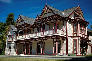
Victoria Mansions is a residential Category II heritage building in central Christchurch, New Zealand.
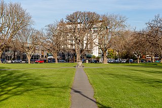
Latimer Square is an urban park in central Christchurch, New Zealand. It is located 400 metres (440 yd) east of the city's centre, Cathedral Square. Many commemorative events take place in Latimer Square. The square lies between the major urban thoroughfares of Gloucester Street and Worcester Street. Madras Street runs north and south to Latimer Square. The square is grassed and crossed by concrete paths and edged by mature trees. It covers an area of a little over 1.8 hectares.
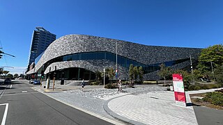
Te Pae Christchurch Convention Centre is a convention centre located in Christchurch Central City, New Zealand. The centre is a replacement for the previous Christchurch Convention Centre that was demolished after the 2011 Christchurch earthquake. Originally known as the Convention Centre Precinct, construction was funded by the New Zealand Government as part of the Christchurch Central Recovery Plan. The centre is owned by the Crown through Rau Paenga Crown Infrastructure Delivery Ltd state-owned enterprise, and managed by ASM Global. The polysemous name Te Pae is "inspired" by the Māori language, and can roughly be interpreted to mean "gathering place".
Maria Chen is a New Zealand architect and a former co-chair of Architecture + Women NZ.


