
Cathedral Square, locally known simply as the Square, is the geographical centre and heart of Christchurch, New Zealand, where the city's Anglican cathedral, ChristChurch Cathedral is located. The square stands at the theoretical crossing of the city's two main orthogonal streets, Colombo Street and Worcester Street, though in practice both have been either blocked off or detoured around the square itself. The square was badly damaged in the February 2011 Christchurch earthquake.
William Brassington was a stonemason, sculptor and builder practising in Christchurch, New Zealand in the late 19th century. His sculptured carving on many of the city's unique Gothic revival public buildings is regarded as some of the finest in the Southern Hemisphere. His work is celebrated around New Zealand and he died when he was around 65
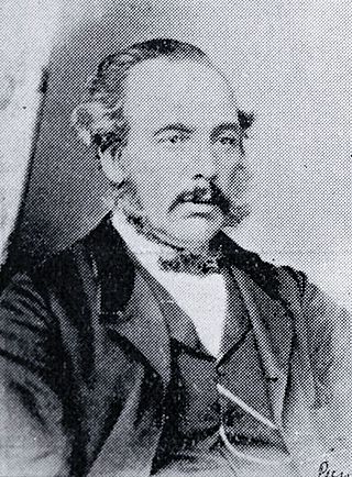
Isaac Luck was a New Zealand architect. A professional builder, he arrived in Lyttelton on the Steadfast in 1851. He was the third chairman of the Christchurch Town Council. He was the brother-in-law of and in partnership with Benjamin Mountfort, and was the less well-known architectural partner for the design of the Canterbury Provincial Council Buildings.
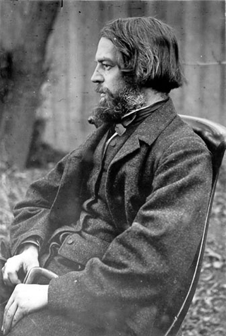
Benjamin Woolfield Mountfort was an English emigrant to New Zealand, where he became one of the country's most prominent 19th-century architects. He was instrumental in shaping the city of Christchurch's unique architectural identity and culture, and was appointed the first official Provincial Architect of the developing province of Canterbury. Heavily influenced by the Anglo-Catholic philosophy behind early Victorian architecture, he is credited with importing the Gothic revival style to New Zealand. His Gothic designs constructed in both wood and stone in the province are considered unique to New Zealand. Today, he is considered the founding architect of the province of Canterbury.
John Kendrick Archer was a Baptist Minister, Mayor of Christchurch and member of the New Zealand Legislative Council.

Maxwell Bury was an English-born architect who was active in New Zealand in the 19th century. He is best remembered for his buildings for the University of Otago.

Christchurch Central City or Christchurch City Centre is the geographical centre and the heart of Christchurch, New Zealand. It is defined as the area within the Four Avenues and thus includes the densely built up central city, some less dense surrounding areas of residential, educational and industrial usage, and green space including Hagley Park, the Christchurch Botanic Gardens and the Barbadoes Street Cemetery.

John Anderson was the second Mayor of Christchurch in New Zealand 1868–1869, and a successful businessman. He had a close connection with three buildings that have later received Category I heritage registrations by Heritage New Zealand. Two of these buildings were demolished following the February 2011 Christchurch earthquake.

Colombo Street is a main road of the city of Christchurch, New Zealand. It runs south-north through the centre of Christchurch with a break at Cathedral Square. As with many other central Christchurch streets, it is named for a colonial Anglican bishopric, Colombo, Sri Lanka in what at the time was known as Ceylon. Parts of the street which run through Sydenham were known as Addison Street during the 1880s, and some parts were known as Colombo Road.

The Civic in Manchester Street, Christchurch Central City, was one of the former civic buildings of Christchurch City Council (CCC). Built in 1900, it was first used as an exhibition hall, a cinema and then a theatre. It burned down in 1917. The northern part of the building was purchased by CCC and opened as the civic office in 1924, and served this purpose until 1980. After that it had several uses, including a restaurant, bar and live music venue. The building was heavily damaged in the February 2011 Christchurch earthquake, and was demolished.

St Paul's Church was a heritage-listed former Presbyterian church in Cashel Street, Christchurch. Built in 1877, the church was registered by the New Zealand Historic Places Trust as a Category I heritage building. Following the February 2011 Christchurch earthquake, the building was removed from the heritage list and demolished.

The Church of St Michael and All Angels is an Anglican church located at 84 Oxford Terrace, Christchurch, New Zealand.
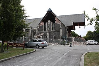
St Luke's Church was an Anglican church located in Christchurch, New Zealand. The former church was built on one of the five sites set aside in the central city in the original survey of Christchurch for the Anglican church and the building was registered as a Category II historic place with the New Zealand Historic Places Trust. Following sustained damage caused by the February 2011 Christchurch earthquake, the building was demolished in July 2011.

The Octagon, Christchurch, the former Trinity Church or Trinity Congregational Church designed by Benjamin Mountfort, later called the State Trinity Centre, is a Category I heritage building listed with Heritage New Zealand. Damaged in the 2010 Canterbury earthquake and red-stickered after the February 2011 Christchurch earthquake, the building was threatened with demolition like most other central city heritage buildings. In June 2012, it was announced that the building will be saved, repaired and earthquake strengthened.

Cranmer Square is an urban park in central Christchurch, New Zealand. It is located 800 metres (870 yd) northwest of the city's centre, Cathedral Square. The major arterial route of Montreal Street skirts the edge of the square. The square is grassed and crossed by concrete paths and edged by mature trees. It covers an area of 1.9 hectares.

The Cardboard Cathedral, formally called the Transitional Cathedral, in Christchurch, New Zealand, is the transitional pro-cathedral of the Anglican Diocese of Christchurch, replacing ChristChurch Cathedral, which was significantly damaged in the 2011 Christchurch earthquake. The Cardboard Cathedral was designed by the Japanese architect Shigeru Ban and opened in August 2013. It is located on the site of the former St John the Baptist Church on the corner of Hereford and Madras Streets in Latimer Square, several blocks from the permanent location of ChristChurch Cathedral.
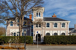
The Christchurch Club is a historic private members' club in the central city of Christchurch, New Zealand. The older of the two Christchurch clubs, it was founded by rural landholders in 1856; the rival organisation, the Canterbury Club, was a breakaway that was founded by urban professionals in 1872.
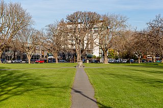
Latimer Square is an urban park in central Christchurch, New Zealand. It is located 400 metres (440 yd) east of the city's centre, Cathedral Square. Many commemorative events take place in Latimer Square. The square lies between the major urban thoroughfares of Gloucester Street and Worcester Street. Madras Street runs north and south to Latimer Square. The square is grassed and crossed by concrete paths and edged by mature trees. It covers an area of a little over 1.8 hectares.

Worcester Street is a road in the central city of Christchurch, New Zealand. It runs from the intersection of Rolleston Avenue in the west, and terminates in the east at the intersection of Woodham Road in Linwood. Between Rolleston Avenue and Cambridge Terrace, it is known as Worcester Boulevard.

