
Lyttelton is a port town on the north shore of Lyttelton Harbour / Whakaraupō, at the northwestern end of Banks Peninsula and close to Christchurch, on the eastern coast of the South Island of New Zealand.

A time ball or timeball is a time-signalling device. It consists of a large, painted wooden or metal ball that is dropped at a predetermined time, principally to enable navigators aboard ships offshore to verify the setting of their marine chronometers. Accurate timekeeping is essential to the determination of longitude at sea.

Cathedral Square, locally known simply as the Square, is the geographical centre and heart of Christchurch, New Zealand, where the city's Anglican cathedral, ChristChurch Cathedral is located. The square stands at the theoretical crossing of the city's two main orthogonal streets, Colombo Street and Worcester Street, though in practice both have been either blocked off or detoured around the square itself. The cathedral was badly damaged in the February 2011 Christchurch earthquake.
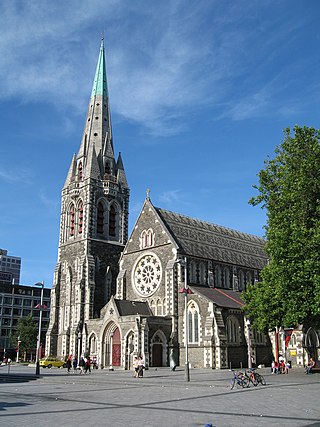
ChristChurch Cathedral, also called Christ Church Cathedral and (rarely) Cathedral Church of Christ, is a deconsecrated Anglican cathedral in the city of Christchurch, New Zealand. It was built between 1864 and 1904 in the centre of the city, surrounded by Cathedral Square. It became the cathedral seat of the Bishop of Christchurch, who is in the New Zealand tikanga of the Anglican Church in Aotearoa, New Zealand and Polynesia.

John Anderson was the second Mayor of Christchurch in New Zealand 1868–1869, and a successful businessman. He had a close connection with three buildings that have later received Category I heritage registrations by Heritage New Zealand. Two of these buildings were demolished following the February 2011 Christchurch earthquake.
The 2010 Canterbury earthquake struck the South Island of New Zealand with a moment magnitude of 7.1 at on 4 September, and had a maximum perceived intensity of X (Extreme) on the Mercalli intensity scale. Some damaging aftershocks followed the main event, the strongest of which was a magnitude 6.3 shock known as the Christchurch earthquake that occurred nearly six months later on 22 February 2011. Because this aftershock was centred very close to Christchurch, it was much more destructive and resulted in the deaths of 185 people.
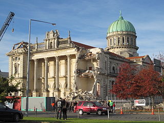
A major earthquake occurred in Christchurch on Tuesday 22 February 2011 at 12:51 p.m. local time. The 6.2 earthquake struck the entire of the Canterbury region in the South Island, centred 6.7 kilometres (4.2 mi) south-east of the central business district. It caused widespread damage across Christchurch, killing 185 people, in New Zealand's fifth-deadliest disaster.

The Hotel Grand Chancellor was a major four-star hotel in the centre of Christchurch in New Zealand, one of eleven Hotel Grand Chancellor establishments across Australia and New Zealand. The hotel was located at 161 Cashel Street, close to the city's City Mall central shopping precinct.

The Durham Street Methodist Church in Christchurch was the earliest stone church constructed in the Canterbury region of New Zealand. It is registered as a "Historic Place – Category I" by Heritage New Zealand.

Holy Trinity Avonside was a heritage-listed Anglican church located in Linwood, Christchurch, New Zealand. It was registered as a "Historic Place – Category I" by the New Zealand Historic Places Trust. It was "damaged beyond the point of repair" in the February 2011 Christchurch earthquake and was demolished the following September.

The Lyttelton Times Building, last known as Base Backpackers, in 56 Cathedral Square, Christchurch Central City, was the last headquarters of the Lyttelton Times before its demise in 1935 as the then-oldest newspaper in New Zealand. The building in Chicago School architectural style was registered with New Zealand Historic Places Trust as a Category I heritage item, with the registration number 7216. The building's last use was as a backpackers' hostel and a restaurant. It was demolished following the February 2011 Christchurch earthquake.
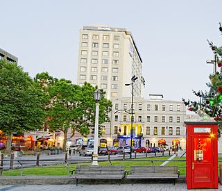
Warner's Hotel in 50 Cathedral Square, Christchurch is the site of a hotel established in 1863. The original building, extended on numerous occasions, burned down in 1900. A new building was built in 1901. Again, it underwent numerous alterations. A fourth storey was added in 1910 and the northern end of the building was demolished in 1917 and a theatre built in its place to create a noise buffer to the printing presses of the adjoining Lyttelton Times Building. The theatre was demolished in 1996 and patrons enjoyed a beer garden. In 2010, a high-rise Novotel hotel opened on the site of the beer garden and in the process, the historical and symmetrical 1901 façade was recreated.
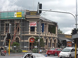
The Carlton Hotel in Christchurch was an historic pub on the corner of Papanui Road and Bealey Avenue. Built in 1906 for the New Zealand International Exhibition, it was registered by the New Zealand Historic Places Trust as a Category II heritage building. The building was damaged in the February 2011 Christchurch earthquake and demolished on 9 April 2011.

The Bridge of Remembrance is one of two main war memorials in Christchurch, New Zealand. It is dedicated to those who died in World War I, and serves as a memorial for those who participated in two World Wars as well as subsequent conflicts in Borneo, Korea, Malaya, and Vietnam. Owned by Christchurch City Council, it is located on the Cashel Street Bridge at the head of City Mall. The Bridge of Remembrance was repaired and strengthened following the 2011 Christchurch earthquake and was reopened with a rededication ceremony held on Anzac Day in 2016.

The June 2011 Christchurch earthquake was a shallow magnitude 6.0 earthquake that occurred on 13 June 2011 at 14:20 NZST. It was centred at a depth of 7 km (4.3 mi), about 5 km (3 mi) south-east of Christchurch, which had previously been devastated by a magnitude 6.2 MW earthquake in February 2011. The June quake was preceded by a magnitude 5.9 ML tremor that struck the region at a slightly deeper 8.9 km (5.5 mi). The United States Geological Survey reported a magnitude of 6.0 Mw and a depth of 9 km (5.6 mi).

Clarendon Tower was a high rise building on Worcester Street at Oxford Terrace in the Christchurch Central City, New Zealand. Built on the site of the former Clarendon Hotel, the façade of the historic building was kept in the redevelopment and was protected by the New Zealand Historic Places Trust as a Category II heritage structure. Following damage from the February 2011 Christchurch earthquake, the 17-storey building has been demolished.

St Saviour’s at Holy Trinity is an Anglican church in Lyttelton, Christchurch, New Zealand. St Saviour's Chapel was relocated from West Lyttelton to Christchurch's Cathedral Grammar School in the 1970s. Following the earthquakes and the demolition of Holy Trinity Church, Lyttelton, St Saviour's was returned to Lyttelton to the site of Holy Trinity in 2013.

The Octagon, Christchurch, the former Trinity Church or Trinity Congregational Church designed by Benjamin Mountfort, later called the State Trinity Centre, is a Category I heritage building listed with Heritage New Zealand. Damaged in the 2010 Canterbury earthquake and red-stickered after the February 2011 Christchurch earthquake, the building was threatened with demolition like most other central city heritage buildings. In June 2012, it was announced that the building will be saved, repaired and earthquake strengthened.
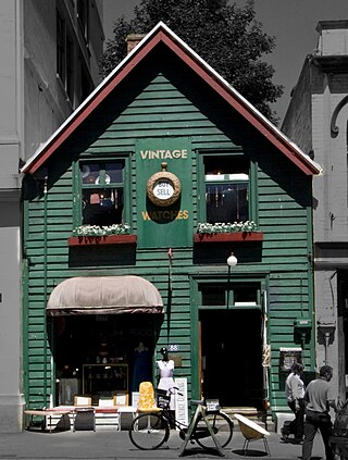
Shand's Emporium, previously known as Gee's, is a historic building in the central city of Christchurch, New Zealand. One of the oldest commercial buildings to remain from the time Christchurch was founded, it was relocated in June 2015 from its original location in Hereford Street to Manchester Street, where it is placed adjacent to another heritage building, The Octagon.

Riccarton House is an historic building in Christchurch, New Zealand. It is part of the Riccarton estate, the first area in Christchurch lived in by white settlers, after which the suburb of Riccarton is named. The house was commissioned by Jane Deans, the widow of Canterbury pioneer John Deans, and finished in 1856. It was twice extended; first in 1874, and the work carried out in 1900 more than doubled the size of the house. The Riccarton estate has in stages become the property of Christchurch City Council and Riccarton House itself was sold by the Deans family to the city in 1947. Damaged by the earthquakes in 2010 and 2011, the repaired and renovated building was reopened in June 2014. Riccarton House is used as a restaurant and for functions, and a popular market is held on Saturdays in front of it.


