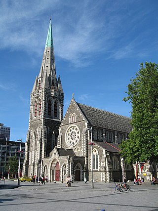
ChristChurch Cathedral, also called Christ Church Cathedral and (rarely) Cathedral Church of Christ, is a deconsecrated Anglican cathedral in the city of Christchurch, New Zealand. It was built between 1864 and 1904 in the centre of the city, surrounded by Cathedral Square. It became the cathedral seat of the Bishop of Christchurch, who is in the New Zealand tikanga of the Anglican Church in Aotearoa, New Zealand and Polynesia.

Canterbury Television was an independent television station broadcasting in Canterbury, New Zealand.

Ao Tawhiti or Ao Tawhiti Unlimited Discovery is a state area school in Christchurch, New Zealand. It was established by the merging of two separate Christchurch inner city schools; the primary school Discovery 1 and the secondary school Unlimited Paenga Tawhiti.

Twinkle Toes is the largest excavator in the Southern Hemisphere. It was used in Christchurch to demolish tall buildings following the 2010 and 2011 earthquakes before moving to Wellington following the 2016 Kaikōura earthquake.

John Anderson was the second Mayor of Christchurch in New Zealand 1868–1869, and a successful businessman. He had a close connection with three buildings that have later received Category I heritage registrations by Heritage New Zealand. Two of these buildings were demolished following the February 2011 Christchurch earthquake.
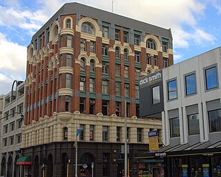
Manchester Courts, earlier known as the MLC Building, was a commercial high-rise building in the Christchurch Central City. Built in 1905–1906 for the New Zealand Express Company, it was at the time the tallest commercial building in Christchurch. A Category I heritage building, it suffered serious structural damage in the 2010 Canterbury earthquake and was condemned to be demolished. Demolition began on 19 October, and was completed in February 2011.

The Hotel Grand Chancellor was a major four-star hotel in the centre of Christchurch in New Zealand, one of eleven Hotel Grand Chancellor establishments across Australia and New Zealand. The hotel was located at 161 Cashel Street, close to the city's City Mall central shopping precinct.

St Elmo Courts was a residential high rise building constructed in 1930 in the city centre of Christchurch, New Zealand. Used mainly as an office building in later years, it had a Category II heritage listing by the New Zealand Historic Places Trust. It was demolished in March 2011, having suffered significant damage in the 2010 Canterbury earthquake and more damage in the subsequent February 2011 Christchurch earthquake.

The Press Building, located in Cathedral Square in Christchurch, was the home of The Press between 1909 and February 2011. The building, designed in the Perpendicular Gothic style, was registered with the New Zealand Historic Places Trust as a Category I heritage item, with the registration number 302. It suffered significant damage in the February 2011 Christchurch earthquake, with one staff member killed in the collapsed top floor. The building was demolished in July and August of 2011.
The CTV Building was the headquarters of Canterbury Television and other companies. Located on the corner of Cashel and Madras Streets in Christchurch Central City, New Zealand. It became one of the symbols of the February 2011 Christchurch earthquake after 115 people lost their lives when the building collapsed during the disaster; the deaths made up about 60% of the earthquake's total fatalities.

Clarendon Tower was a high rise building on Worcester Street at Oxford Terrace in the Christchurch Central City, New Zealand. Built on the site of the former Clarendon Hotel, the façade of the historic building was kept in the redevelopment and was protected by the New Zealand Historic Places Trust as a Category II heritage structure. Following damage from the February 2011 Christchurch earthquake, the 17-storey building has been demolished.

Wharetiki, for some time known as Glenfell House, was an Edwardian timber dwelling in Colombo Street, Christchurch in New Zealand. Built in 1904 for businessman and philanthropist Matthew Barnett, it was damaged in the February 2011 Christchurch earthquake. After the Canterbury Earthquake Recovery Authority ordered the demolition of the Category II heritage building registered by Heritage New Zealand, it was the first court challenge of CERA's post-earthquake powers. In July 2011, the High Court decided in the authority's favour and the building was demolished the following day.

St Paul's Church was a heritage-listed former Presbyterian church in Cashel Street, Christchurch. Built in 1877, the church was registered by the New Zealand Historic Places Trust as a Category I heritage building. Following the February 2011 Christchurch earthquake, the building was removed from the heritage list and demolished.

City Mall is the main pedestrian mall in the central city of Christchurch, New Zealand, comprising two sections of Cashel Street plus the Bridge of Remembrance and one section of High Street. It is also known colloquially as Cashel Mall. The Bridge of Remembrance was pedestrianised in 1976. The main mall was closed to traffic on 11 January 1982 and formally reopened as a pedestrian mall on 7 August, but it was not until 1992 that the entire mall was paved. The mall was redeveloped between 2006 and 2009, and track was installed for an expansion of the heritage tram network.

St Saviour’s at Holy Trinity is an Anglican church in Lyttelton, Christchurch, New Zealand. St Saviour's Chapel was relocated from West Lyttelton to Christchurch's Cathedral Grammar School in the 1970s. Following the earthquakes and the demolition of Holy Trinity Church, Lyttelton, St Saviour's was returned to Lyttelton to the site of Holy Trinity in 2013.

The Octagon, Christchurch, the former Trinity Church or Trinity Congregational Church designed by Benjamin Mountfort, later called the State Trinity Centre, is a Category I heritage building listed with Heritage New Zealand. Damaged in the 2010 Canterbury earthquake and red-stickered after the February 2011 Christchurch earthquake, the building was threatened with demolition like most other central city heritage buildings. In June 2012, it was announced that the building will be saved, repaired and earthquake strengthened.

The implosion of Radio Network House in 2012 was the first implosion used in New Zealand to demolish a building, and was a "test case" for the potential to use such a demolition method on similar buildings in Christchurch Central City that had been damaged in the 2011 earthquake. Like most other large buildings in central Christchurch, Radio Network House was damaged beyond repair in the 2011 earthquake, and the Canterbury Earthquake Recovery Authority (CERA) added it to the demolition list in August 2011. In July 2012, it was announced that the building was going to be imploded, involving a specialist company from the United States with considerable experience in this type of work.

The Hornby Clocktower was an iconic Christchurch building, situated in the suburb of Hornby on New Zealand State Highway 1. It marked the southern entrance to Christchurch for over 50 years.
Shand's Emporium, previously known as Gee's, is a historic building in the central city of Christchurch, New Zealand. One of the oldest commercial buildings to remain from the time Christchurch was founded, it was relocated in June 2015 from its original location in Hereford Street to Manchester Street, where it is placed adjacent to another heritage building, The Octagon.
