Westland District

Last updated

Westland District
Gillespie Beach, Westland, New Zealand.jpg
Gillespie Beach, Westland
Westland DC.PNG
Coordinates: 43°25′52″S170°09′18″E / 43.431°S 170.155°E / -43.431; 170.155
Country New Zealand
Region West Coast
Wards
Seat Hokitika
Government
  MayorHelen Lash
   Territorial authority Westland District Council
Area
[1]
  Total11,827.86 km2 (4,566.76 sq mi)
Population
 (June 2023) [2]
  Total8,940
  Density0.76/km2 (2.0/sq mi)
Time zone UTC+12 (NZST)
  Summer (DST) UTC+13 (NZDT)
Postcode(s)
Area code 03
Website www.westlanddc.govt.nz OOjs UI icon edit-ltr-progressive.svg

Westland District is a territorial authority district on the West Coast of New Zealand's South Island. It is administered by the Westland District Council. The district's population is 8,940(June 2023). [2]

Contents

History

Westland was originally a part of Canterbury Province, administered from Christchurch, on the east coast. The booming population as a result of the gold rush, together with the difficulty of travel and communication across the Southern Alps, led first to the creation of a special Westland County, then the formal separation of Westland from Canterbury to form the short-lived Westland Province (1873–1876). Westland Province also included what is now the southern portion of Grey District, with the provincial boundary at the Grey and Arnold rivers. Greymouth proper was in Westland Province, Cobden, on the north bank of the Grey River, was in Nelson Province.

After the abolition of the provinces in 1876, a new Westland County was created with roughly the same borders as the province. About this time, the population relative to the rest of the country began to decline, as the easily accessible gold soon ran out and the conditions were not ideal for farming. Local government changes saw the hinterland of Greymouth on both sides of the Grey River transformed into Greymouth Borough and Grey County and subsequently into Grey District, which includes portions of both historical provinces.

Westland as a unit of government emerged largely intact from the local government reforms of the 1980s and 1990s, merely changing from a county to a district and incorporating the Borough of Hokitika.

Recently, the population has begun to grow more quickly due to "lifestyle" residents moving into the district.

Geography

The district consists of a long, thin strip of land between the crest of the Southern Alps and the Tasman Sea. The low-lying areas near the coast are a mixture of pastoral farmland and temperate rainforest. Westland temperate rainforests contain many conifers and receives high rates of precipitation due to orographic lifting caused by the Southern Alps. The eastern part of the district is steep and mountainous. Many small rivers flow down from the mountains. The middle part of the district notably contains the Franz Josef and Fox glaciers.

In the north, the Taramakau River, the largest river in the district, forms the boundary with the Grey District. The crest of the Southern Alps marks the eastern boundary. A small southern boundary lies between Westland proper and Fiordland, which lies within the Southland District. This boundary cannot be crossed by road.

Urban areas and settlements

Hokitika, the district seat, is the only town in the Westland District with a population over 1,000. It is home to 3,120 people, 34.9% of the district's population. [2]

Other settlements and localities include:

Hokitika Ward:

Northern Ward:

Southern Ward:

Notes:bold - settlement; normal text - locality; italics - minor locality

Demography

Westland District covers 11,827.86 km2 (4,566.76 sq mi) [1] and had an estimated population of 8,940 as of June 2023, [2] with a population density of 0.76 people per km2. The district is the most sparsely populated of New Zealand's 67 territorial authorities.

Historical population
YearPop.±% p.a.
20068,403    
20138,304−0.17%
20188,640+0.80%
Source: [3]

Westland District had a population of 8,640 at the 2018 New Zealand census, an increase of 336 people (4.0%) since the 2013 census, and an increase of 237 people (2.8%) since the 2006 census. There were 3,747 households, comprising 4,356 males and 4,287 females, giving a sex ratio of 1.02 males per female. The median age was 44.4 years (compared with 37.4 years nationally), with 1,449 people (16.8%) aged under 15 years, 1,446 (16.7%) aged 15 to 29, 4,212 (48.8%) aged 30 to 64, and 1,536 (17.8%) aged 65 or older.

Ethnicities were 86.5% European/Pākehā, 14.4% Māori, 2.0% Pasifika, 5.2% Asian, and 3.0% other ethnicities. People may identify with more than one ethnicity.

The percentage of people born overseas was 16.3, compared with 27.1% nationally.

Although some people chose not to answer the census's question about religious affiliation, 51.4% had no religion, 36.7% were Christian, 0.3% had Māori religious beliefs, 0.9% were Hindu, 0.3% were Muslim, 0.5% were Buddhist and 1.7% had other religions.

Of those at least 15 years old, 1,056 (14.7%) people had a bachelor's or higher degree, and 1,656 (23.0%) people had no formal qualifications. The median income was $29,600, compared with $31,800 nationally. 960 people (13.4%) earned over $70,000 compared to 17.2% nationally. The employment status of those at least 15 was that 3,975 (55.3%) people were employed full-time, 1,137 (15.8%) were part-time, and 153 (2.1%) were unemployed. [3]

Individual statistical areas in Westland District (2018 census) [4]
SA2 nameAreaPopulationDensityMedian ageMedian income
Arahura-Kumara262.57 km2 (101.38 sq mi)1,2334.70/km2 (12.17/sq mi)49.8 years$31,000
Haast4,099.09 km2 (1,582.67 sq mi)2580.06/km2 (0.16/sq mi)52.6 years$27,000
Hokitika3.91 km2 (1.51 sq mi)2,892739.64/km2 (1,915.66/sq mi)47.5 years$27,300
Hokitika Rural154.13 km2 (59.51 sq mi)1,4409.34/km2 (24.19/sq mi)46.2 years$34,100
Hokitika Valley-Otira1,614.48 km2 (623.35 sq mi)6510.40/km2 (1.04/sq mi)36.6 years$28,500
Waitaha1,499.99 km2 (579.15 sq mi)4500.30/km2 (0.78/sq mi)51.7 years$24,300
Westland Glaciers-Bruce Bay3,057.41 km2 (1,180.47 sq mi)1,0740.35/km2 (0.91/sq mi)31.3 years$33,000
Whataroa-Harihari1,136.25 km2 (438.71 sq mi)6420.57/km2 (1.48/sq mi)40.7 years$31,400
Individual wards (2018 boundaries)
NameArea (km2)PopulationDensity (per km2)HouseholdsMedian ageMedian income
Northern Ward2,344.822,9071.241,19746.9 years$30,100
Hokitika Ward16.563,651220.471,60547.4 years$28,400
Southern Ward9,466.432,0820.2294535.0 years$31,500
New Zealand37.4 years$31,800

Government

The Westland District is governed by an elected council, headed by an mayor, who is elected at large. The current mayor is Helen Lash. Councillors are elected to represent multi-member wards. Three councillors are elected for the Northern Ward, three for the Southern Ward, and four for the town of Hokitika.

The district is one of three included within the West Coast Region.

Economy

In the early years of settlement in Westland, gold was a major commodity, bringing prospectors flocking into the area. After the gold ran out, those who remained turned to pastoral farming. (Unlike the more northern parts of the West Coast, Westland has not developed coal mining.) Recently, tourism has become more important, with drawcards such as the glaciers, and events such as the Hokitika Wildfoods Festival.

Related Research Articles

<span class="mw-page-title-main">South Island</span> One of the two main New Zealand islands

The South Island, also officially named Te Waipounamu, is the larger of the two major islands of New Zealand in surface area, the other being the smaller but more populous North Island. It is bordered to the north by Cook Strait, to the west by the Tasman Sea, and to the south and east by the Pacific Ocean. The South Island covers 150,437 square kilometres (58,084 sq mi), making it the world's 12th-largest island, constituting 56% of New Zealand's land area. At low altitude, it has an oceanic climate.

<span class="mw-page-title-main">West Coast Region</span> Region of New Zealand

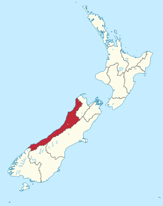
The West Coast is a region of New Zealand on the west coast of the South Island that is administered by the West Coast Regional Council, and is known co-officially as Te Tai Poutini. It comprises the territorial authorities of Buller District, Grey District and Westland District. The principal towns are Westport, Greymouth and Hokitika. The region, one of the more remote areas of the country, is also the most sparsely populated. With a population of just 32,900 people, the West Coast is the least populous region in New Zealand. The population in the region grew by 0.4% over the year to July 2023.

<span class="mw-page-title-main">Haast, New Zealand</span> Town in the South Island of New Zealand

Haast is a small town in the Westland District territorial authority on the West Coast of New Zealand's South Island. The township is beside the Haast River, 3 kilometres (2 mi) south of Haast Junction, on State Highway 6. The Haast region is in Te Wahipounamu – The South West New Zealand World Heritage, a UNESCO World Heritage Site designated in 1990.

<span class="mw-page-title-main">Greymouth</span> Town in West Coast, New Zealand

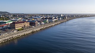
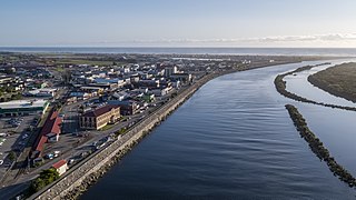
Greymouth is the largest town in the West Coast region in the South Island of New Zealand, and the seat of the Grey District Council. The population of the whole Grey District is 14,250, which accounts for 43% of the West Coast's inhabitants. The Greymouth urban area had an estimated population of 8,340. A large proportion of the District, 65%, is part of the Conservation Estate owned and managed by the Department of Conservation making Greymouth a natural centre for walkers and trampers.

<span class="mw-page-title-main">Hokitika</span> Town in West Coast, New Zealand

Hokitika is a town in the West Coast region of New Zealand's South Island, 40 kilometres (25 mi) south of Greymouth, and close to the mouth of the Hokitika River. It is the seat and largest town in the Westland District. The town's estimated population is 3,120 as of June 2023.

<span class="mw-page-title-main">Taramakau River</span> River in New Zealand

The Taramakau River is a river of the West Coast Region of the South Island of New Zealand. It rises in the Southern Alps / Kā Tiritiri o te Moana near Harper Pass, 80 kilometres (50 mi) due east of Hokitika, and runs westward for 75 kilometres (47 mi) into the Tasman Sea 15 kilometres (9.3 mi) south of Greymouth.

<span class="mw-page-title-main">Ross, New Zealand</span> Town in the West Coast Region of New Zealand

Ross is a small town located in the Westland District on the West Coast of New Zealand's South Island, 27 kilometres (17 mi) south-west of Hokitika and 46 kilometres (29 mi) north-east of Hari Hari by road.

<span class="mw-page-title-main">Selwyn District</span> Territorial authority district in Canterbury, New Zealand

Selwyn District is a predominantly rural district in central Canterbury, on the east coast of New Zealand's South Island. It is named after the Selwyn River / Waikirikiri, which is in turn named after Bishop George Selwyn, the first Anglican bishop of New Zealand who, in 1843 and 1844, travelled the length of the country by horse, foot, boat and canoe, leaving in his wake a sprinkling of locations that now bear his name.

<span class="mw-page-title-main">Dobson, New Zealand</span> Town in the South Island of New Zealand

Dobson is a small town on the banks of the Grey River in the South Island of New Zealand. It is 10 kilometres (6 mi) east from the river's mouth at Greymouth. The settlement of Taylorville is across the river from Dobson, but no bridge directly connects the two. State Highway 7 passes through Dobson.

<span class="mw-page-title-main">Grey District</span> Territorial authority district in West Coast Regional Council, New Zealand

Grey District is a district in the West Coast Region of New Zealand that covers Greymouth, Runanga, Blackball, Cobden, and settlements along the Grey River. It has a land area of 3,474.44 square kilometres (1,341.49 sq mi). The seat of the Grey District Council, the local government authority that administers the district, is at Greymouth, where 58.5% of the district's population live.

<span class="mw-page-title-main">Hurunui District</span> Territorial authority district in Canterbury, New Zealand

Hurunui District is a territorial local government district within the Canterbury Region on the east coast of New Zealand's South Island, north of Christchurch. It stretches from the east coast to the Main Divide. Its land area is 8,640.96 square kilometres (3,336.29 sq mi).

<span class="mw-page-title-main">Hari Hari</span> Town in the West Coast Region of New Zealand

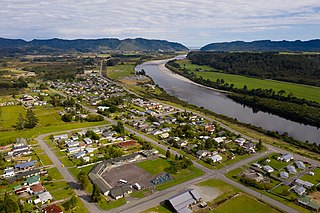
Hari Hari is a small rural settlement in the south west of the West Coast region of New Zealand's South Island. The name has a Maori meaning, from Te Aka Maori/English Dictionary, as "to take/carry joy" or, as local legend suggests, "come together in unison" from a Maori canoe paddling chant/song. In recent years, Hari Hari has been increasingly referred to as "Harihari" with Maori meaning as "ambulance". No official statutory process has taken place in order for this to happen.

<span class="mw-page-title-main">Franz Josef / Waiau</span> Town in the West Coast Region of New Zealand

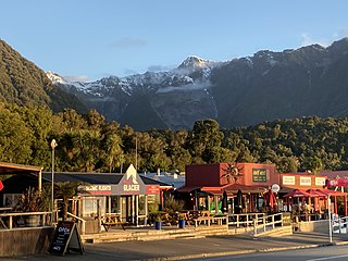
Franz Josef is a small town in the West Coast region of the South Island of New Zealand. Whataroa is 32 kilometres (20 mi) to the north-east, and the township of Fox Glacier is 23 kilometres (14 mi) to the south-west. The Waiho River runs from the Franz Josef Glacier to the south, through the town, and into the Tasman Sea to the north-west.

Kaniere is a small town in the Westland District of the West Coast region of New Zealand's South Island. Hokitika lies to the north-west, and the Hokitika River flows past to the south-west.

<span class="mw-page-title-main">Ahaura</span> Town in the South Island of New Zealand

Ahaura is a town in the West Coast region of New Zealand's South Island, sited where the Ahaura River flows into the Grey River. State Highway 7 and the Stillwater–Ngākawau railway line pass through the town. Greymouth is 34 kilometres (21 mi) to the south-west, and Reefton is 44 kilometres (27 mi) to the north-east.

<span class="mw-page-title-main">Fox Glacier (town)</span> Town in the West Coast Region of New Zealand

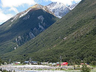
Fox Glacier, called Weheka until the 1940s, is a village on the West Coast of the South Island of New Zealand. The village is close to the eponymous Fox Glacier / Te Moeka o Tuawe.

<span class="mw-page-title-main">Arthur's Pass</span> Settlement in Canterbury, New Zealand

Arthur's Pass, previously called Camping Flat then Bealey Flats, and for some time officially Arthurs Pass, is a township in the Southern Alps of the South Island of New Zealand, located in the Selwyn district. It is a popular base for exploring Arthur's Pass National Park.

<span class="mw-page-title-main">Ashburton District</span> Territorial authority district in Canterbury, New Zealand

Ashburton District is a territorial authority district in the Canterbury Region of the South Island of New Zealand. It encompasses the town of Ashburton, a number of small towns and settlements and the surrounding rural area, roughly coterminous with Mid Canterbury. The district had a population of 36,800 as of June 2023.

<span class="mw-page-title-main">Taylorville, New Zealand</span> Town in New Zealand

Taylorville is a small town on the banks of the Grey River, It is roughly 10 kilometers from the mouth of the river in Greymouth.

<span class="mw-page-title-main">Westland County</span> Provinces of New Zealand in South Island

Westland County, also known as County of Westland, was a local government area on the West Coast of New Zealand's South Island. It existed from 1868 to 1873, and then from 1876 until 1989. In its first incarnation, it constituted the government for the area that was split from the Canterbury Province, with the West Coast Gold Rush having given the impetus for that split. It had the same administrative powers as a provincial council, but the legislative power rested with Parliament in Wellington. The first Westland County was the predecessor to Westland Province.

References

  1. 1 2 "ArcGIS Web Application". statsnz.maps.arcgis.com. Retrieved 11 March 2022.
  2. 1 2 3 4 "Subnational population estimates (RC, SA2), by age and sex, at 30 June 1996-2023 (2023 boundaries)". Statistics New Zealand . Retrieved 25 October 2023. (regional councils); "Subnational population estimates (TA, SA2), by age and sex, at 30 June 1996-2023 (2023 boundaries)". Statistics New Zealand . Retrieved 25 October 2023. (territorial authorities); "Subnational population estimates (urban rural), by age and sex, at 30 June 1996-2023 (2023 boundaries)". Statistics New Zealand . Retrieved 25 October 2023. (urban areas)
  3. 1 2 "Statistical area 1 dataset for 2018 Census". Statistics New Zealand. March 2020. Westland District (057). 2018 Census place summary: Westland District
  4. "2018 Census place summaries | Stats NZ". www.stats.govt.nz. Retrieved 2020-12-14.