The council seat and principal urban area is the city of Whangārei, population 56,100in June 2025.[2] The biggest towns are One Tree Point (3,350), Ruakākā (2,890), Hikurangi (1,640), Waipu (1,450) and Ngunguru (1,180). Smaller towns include Hūkerenui, Portland and Titoki. The district population was 100,600in June 2025.[2]
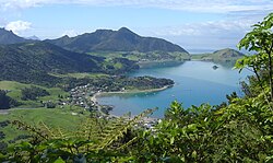
The largest coastal features are Bream Bay and Whangārei Harbour, which has its entrance at the northen end of the bay. There are numerous beaches along the ocean coast and the harbour. Tutukaka is a port for game fishing, and diving and sightseeing excursions. Motu Matakohe or Limestone Island in the harbour is being ecologically restored. The main airport is Whangarei Airport.
There is a district-wide Māori ward and five general wards: Whangārei Urban in the city, Hikurangi-Coastal in the north, Mangakahia-Maungatapere inland to the west, Bream Bay in the south, and Whangārei Heads to the east of the city.
Whangarei District covers 2,711.44km2 (1,046.89sqmi)[4] and had an estimated population of 100,600 as of June 2025,[2] with a population density of 37 people per km2.
Whangarei District had a population of 96,678 in the 2023 New Zealand census, an increase of 5,718 people (6.3%) since the 2018 census, and an increase of 19,683 people (25.6%) since the 2013 census. There were 47,211 males, 49,218 females and 252 people of other genders in 35,535 dwellings.[7] 2.6% of people identified as LGBTIQ+. The median age was 41.6 years (compared with 38.1 years nationally). There were 19,140 people (19.8%) aged under 15 years, 15,465 (16.0%) aged 15 to 29, 41,829 (43.3%) aged 30 to 64, and 20,244 (20.9%) aged 65 or older.[5]
People could identify as more than one ethnicity. The results were 76.3% European (Pākehā); 31.4% Māori; 4.5% Pasifika; 6.4% Asian; 0.7% Middle Eastern, Latin American and African New Zealanders (MELAA); and 2.3% other, which includes people giving their ethnicity as "New Zealander". English was spoken by 97.0%, Māori language by 7.5%, Samoan by 0.3% and other languages by 8.1%. No language could be spoken by 2.0% (e.g. too young to talk). New Zealand Sign Language was known by 0.6%. The percentage of people born overseas was 18.4, compared with 28.8% nationally.
Of those at least 15 years old, 11,343 (14.6%) people had a bachelor's or higher degree, 43,365 (55.9%) had a post-high school certificate or diploma, and 19,200 (24.8%) people exclusively held high school qualifications. The median income was $36,500, compared with $41,500 nationally. 6,681 people (8.6%) earned over $100,000 compared to 12.1% nationally. The employment status of those at least 15 was that 35,892 (46.3%) people were employed full-time, 10,545 (13.6%) were part-time, and 2,256 (2.9%) were unemployed.[5]
This page is based on this Wikipedia article Text is available under the CC BY-SA 4.0 license; additional terms may apply. Images, videos and audio are available under their respective licenses.