Hastings District, New Zealand

Last updated

Hastings District
Hastings District from Peak.jpg
Hastings DC.PNG
Coordinates: 39°38′42″S176°50′35″E / 39.645°S 176.843°E / -39.645; 176.843
Country New Zealand
Region Hawke's Bay Region
Wards
  • Mohaka
  • Heretaunga
  • Flaxmere
  • Kahuranaki
  • Hastings-Havelock North
  • Māori
Seat Hastings
Government
   Mayor Sandra Hazlehurst
  Deputy MayorTania Kerr
   Territorial authority Hastings District Council
Area
[1]
  Land5,226.71 km2 (2,018.04 sq mi)
Population
 (June 2023) [2]
  Total91,900
Time zone UTC+12 (NZST)
  Summer (DST) UTC+13 (NZDT)
Postcode(s)
Area code 06
Website www.hastingsdc.govt.nz OOjs UI icon edit-ltr-progressive.svg

Hastings District is a Territorial authority district within the Hawke's Bay Region, on the east coast of the North Island of New Zealand. It covers the southern half of the Hawke's Bay coast, excluding Napier City, which is a separate territorial authority. Hastings District Council is headquartered in the city of Hastings, the district's largest town.

Contents

The district has an area of 5,227 square kilometres. [3] The population was 91,900 as of June 2023 [2] , which is 1.8% of the population of New Zealand, ranking it tenth in population size out of the seventy-four territorial authorities. This comprises 51,500 people in the Hastings urban area, 15,200 people in the Havelock North urban area, 2,090 people in the Clive urban area, and 23,110 people in rural areas and settlements.

Mayor Sandra Hazlehurst was elected as mayor in a by-election in 2017, [4] and re-elected in the 2019 local elections. [5]

Council history

old Hastings District Council building Council Buildings Hastings (31874754785).jpg
old Hastings District Council building

Local government in the area began with the Havelock North Roads Board in 1871. It was replaced by a Town Board in 1912, and became Havelock North Borough Council in 1952. Hastings was a Town District in 1884. The Hastings Borough Council formed in 1886, and became Hastings City Council in 1956. [6] Hawke's Bay County was established in 1876. [7]

Hastings District was established from the merger of Havelock North Borough Council, Hastings City Council and the Hawke’s Bay County Council as part of the 1989 local government reforms. [6]

Demographics

Hastings District covers 5,226.71 km2 (2,018.04 sq mi) [1] and had an estimated population of 91,900 as of June 2023, [2] with a population density of 17.6 people per km2.

Historical population
YearPop.±% p.a.
1991 64,000    
1996 66,300+0.71%
2001 67,400+0.33%
200670,842+1.00%
201373,245+0.48%
201881,537+2.17%
202385,965+1.06%
Source: [8] [9] [10]
Ethnicities, 2023 Census
EthnicityPopulation
New Zealand European
60,132
Māori
24,435
Pasifika
7,320
Asian
6,513
MELAA
690
Other
1,005

Hastings District had a population of 85,965 in the 2023 New Zealand census, an increase of 4,428 people (5.4%) since the 2018 census, and an increase of 12,720 people (17.4%) since the 2013 census. There were 33,105 dwellings. There were 17,544 people (20.4%) aged under 15 years, 15,402 (17.9%) aged 15 to 29, 37,710 (43.9%) aged 30 to 64, and 15,312 (17.8%) aged 65 or older. [10]

Ethnicities were 69.9% European/Pākehā, 28.4% Māori, 8.5% Pasifika, 7.6% Asian, 0.8% Middle Eastern, Latin American and African New Zealanders, and 1.2% other. People may identify with more than one ethnicity. [10]

Hastings District had a population of 81,537 at the 2018 New Zealand census. There were 28,131 households, comprising 40,029 males and 41,511 females, giving a sex ratio of 0.96 males per female. The median age was 39.1 years (compared with 37.4 years nationally).

The percentage of people born overseas was 17.2, compared with 27.1% nationally.

Although some people chose not to answer the census's question about religious affiliation, 46.4% had no religion, 39.5% were Christian, 3.0% had Māori religious beliefs, 0.8% were Hindu, 0.5% were Muslim, 0.6% were Buddhist and 2.7% had other religions.

Of those at least 15 years old, 10,692 (16.7%) people had a bachelor's or higher degree, and 13,131 (20.6%) people had no formal qualifications. The median income was $28,400, compared with $31,800 nationally. 8,223 people (12.9%) earned over $70,000 compared to 17.2% nationally. The employment status of those at least 15 was that 32,094 (50.3%) people were employed full-time, 9,483 (14.9%) were part-time, and 2,166 (3.4%) were unemployed. [9]

Individual general wards (2018 boundaries)
NameArea (km2)PopulationDensity (per km2)HouseholdsMedian ageMedian income
Mohaka Ward3,448.666,0631.762,14843.3 years$36,400
Heretaunga Ward183.2011,16960.973,84343.8 years$33,200
Hastings-Havelock North Ward26.5046,8961,769.6617,15739.9 years$27,700
Flaxmere Ward6.4011,0251,722.662,91926.7 years$22,200
Kahuranaki Ward1,562.026,3844.092,06443.0 years$34,600
New Zealand37.4 years$31,800

Below is a list of urban areas that contain more than 1,000 population.

Urban areaPopulation
(June 2023) [2] [11]
 % of region
Hastings 51,50056.0%
Havelock North 15,20016.5%
Clive 2,0902.3%
Haumoana 1,2101.5%

Other towns and settlements include (from north to south):

Economy

The district, as one of the largest apple, pear and stone fruit producing areas in New Zealand, has an important relationship with the Napier Port. It has also become an important grape growing and wine production area, with the fruit passing from the growers around Metropolitan Hastings and then to Napier for exporting. Napier is an important service centre for the agriculture and pastoral output of the predominantly rural Hastings District. Shopping is heavily weighted by large format retail in Hastings City, whereas in contrast, Havelock North, Taradale and central Napier retail areas have a more vibrant boutique flavour.

Tourism

Sky Castle, Splash Planet, Hastings Sky Castle, Splash Planet, Hastings.jpg
Sky Castle, Splash Planet, Hastings
Gannet colony on Cape Kidnappers Gannet colony cape kidnappers.jpg
Gannet colony on Cape Kidnappers

Hastings District is historic and welcoming to tourists, although inbound tourism is typically focused on Napier. Hastings features a tourism industry based on 'lifestyle' activities rather than attractions. The majority of tourists are domestic, usually from other regions within New Zealand. Scheduled airline services to Hawke's Bay operate through Hawke's Bay Airport, and the nearby Hastings Aerodrome is available for private planes. Tourism in Hawke's Bay is growing at an extremely rapid rate. In the recent decade, Hawke's Bay Airport's annual passenger numbers have grown from a 2005 count of 297,000 to a count of 476,000 in the year ending 30 June 2015. In the next five years, passenger numbers are expected to exceed 550,000, bringing many new people into Hawke's Bay, with Hastings benefiting from the greater tourism. [12]

Hastings' largest draw card is the wine and food trail established around the productive hinterland. There are over 75 wineries in the surrounding area, including New Zealand's oldest winery restaurant (Vidal Estate). Boutique food industries are becoming popular with cheese, fine meats, and locally produced delicacies seen on display at the Hawkes Bay Farmer's Market (New Zealand's oldest and largest weekly farmer's market). Outdoor leisure activities dominate, with beaches, rivers, mountain biking, tramping, and golf, being popular. In summer, many large-scale events attract domestic tourists, including the Spring Racing Carnival, The Blossom Parade, Harvest Hawkes Bay Weekend, and various concerts and events. The Blossom Festival was once a large national event in the mid-20th century, with charter trains from Wellington and Auckland coming for the event. This, however, has slowly declined in popularity.

Hastings' specialist attractions include: New Zealand's largest water park, called 'Splash Planet', which replaced 'Fantasyland' near the turn of the millennium, Cape Kidnappers (the world's largest mainland gannet colony), Te Mata Peak, and access to an abundance of nature reserves and mountain treks.

Education

Hastings, Flaxmere and Havelock North have secondary schools, and Hastings and Havelock North also have intermediate schools. Some secondary schools in Hastings and Havelock North are single-sex, but there are also co-educational secondary schools in those areas. Te Kura Kaupapa Māori o Te Wananga Whare Tapere o Takitimu is a Māori language immersion school in the Parkvale suburb of Hastings.

Sister cities

Hastings has had a sister city relationship with Guilin in China since 1981. [13] it signed a second agreement with Poutasi in Samoa in May 2023. [14]

Related Research Articles

<span class="mw-page-title-main">North Island</span> One of the two main New Zealand islands

The North Island, also officially named Te Ika-a-Māui, is one of the two main islands of New Zealand, separated from the larger but less populous South Island by Cook Strait. With an area of 113,729 km2 (43,911 sq mi), it is the world's 14th-largest island, constituting 43% of New Zealand's land area. It has a population of 3,997,300, which is 77% of New Zealand's residents, making it the most populous island in Polynesia and the 28th-most-populous island in the world.

<span class="mw-page-title-main">Hawke's Bay</span> Region of New Zealand

Hawke's Bay is a region on the east coast of New Zealand's North Island. The region is named for Hawke Bay, which was named in honour of Edward Hawke. The region's main centres are the cities of Napier and Hastings, while the more rural parts of the region are served by the towns of Waipukurau, Waipawa, and Wairoa.

<span class="mw-page-title-main">Napier, New Zealand</span> City in Hawkes Bay, New Zealand

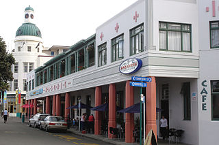
Napier is a city on the eastern coast of the North Island of New Zealand and the seat of the Hawke's Bay region. It is a beachside city with a seaport, known for its sunny climate, esplanade lined with Norfolk pines, and extensive Art Deco architecture. Napier is sometimes referred to as the "Nice of the Pacific", although that is largely outdated and a more common nickname is 'The Art Deco Capital of the world'.

<span class="mw-page-title-main">Hastings, New Zealand</span> City in Hawkes Bay, New Zealand

Hastings is an inland city of New Zealand and is one of the two major urban areas in Hawke's Bay, on the east coast of the North Island. The population of Hastings is 51,500, with a further 15,200 people in Havelock North and 2,090 in Clive. Hastings is about 18 kilometres inland of the coastal city of Napier. These two neighbouring cities are often called "The Bay Cities" or "The Twin Cities".

<span class="mw-page-title-main">Havelock North</span> Town in Hawkes Bay Region, New Zealand

Havelock North is a town in the Hawke's Bay region of the North Island of New Zealand, situated less than 2 km south-east of the city of Hastings. It was a borough for many years until the 1989 reorganisation of local government saw it merged into the new Hastings District, and it is now administered by the Hastings District Council.

<span class="mw-page-title-main">Western Bay of Plenty District</span> Territorial authority district in Bay of Plenty, New Zealand

Western Bay of Plenty District is a territorial district within the Bay of Plenty Region of New Zealand. The district envelops Tauranga city by land, and includes Matakana Island, at the entrance to Tauranga Harbour.

<span class="mw-page-title-main">Takapau</span> Settlement in Hawkes Bay Region, New Zealand

Takapau is a small rural community in the Central Hawkes Bay in New Zealand. It is located 20 kilometres west of Waipukurau, off State Highway 2, and has a population of more than 500.

<span class="mw-page-title-main">Central Hawke's Bay District</span> Territorial authority district in Hawkes Bay, New Zealand

Central Hawke's Bay District is in the Hawke's Bay Region in the North Island of New Zealand. Formed in 1989, it covers an area of 3,333 square kilometres, from Pukehou in the north to Takapau in the south, and from the western Ruahine Range to the Pacific coast in the east. It has a population of 16,000, up from 14,142 in the 2018 census and 12,717 in the 2013 census.

<span class="mw-page-title-main">Tikokino</span> Settlement in Hawkes Bay Region, New Zealand

Tikokino is a town in the Central Hawke's Bay District on the east coast of the North Island of New Zealand. It is located 20 kilometres (12 mi) northwest of Waipawa and 55 kilometres (34 mi) southwest of Hastings. The township is located on State Highway 50.

<span class="mw-page-title-main">Pongaroa</span> Settlement in Manawatū-Whanganui, New Zealand

Pongaroa is a town in the Tararua District, in the southeast of the North Island of New Zealand, 110 kilometres southwest of Hastings and 200 kilometres northeast of Wellington. The nearest town is Pahiatua, 50 kilometres to the west. Popular Ākitio Beach is 30 kilometres to the east. The township straddles Route 52, a road between Masterton and Waipukurau.

<span class="mw-page-title-main">Far North District</span> Territorial authority district in Northland Region, New Zealand

The Far North District is the northernmost territorial authority district of New Zealand, consisting of the northern part of the Northland Peninsula in the North Island. It stretches from North Cape / Otou and Cape Reinga / Te Rerenga Wairua in the north, down to the Bay of Islands, the Hokianga and the town of Kaikohe.

Bunnythorpe is a village in the Manawatū-Whanganui region of New Zealand's North Island, 10 km (6 mi) north of the region's major city, Palmerston North. Dairy farms predominate the surrounding area but the community facilities include Bunnythorpe School, with a roll of about 80 pupils as of 2010 as well as a Rugby Football Club, Country Club and several manufacturing plants. The population was 687 in the 2018 census.

<span class="mw-page-title-main">Napier-Hastings Urban Area</span> Urban area in Hawkes Bay, New Zealand

The Napier-Hastings Urban Area was defined by Statistics New Zealand as a main urban area of New Zealand that was based around the twin cities of Napier and Hastings in the Hawke's Bay Region. It was defined under the New Zealand Standard Areas Classification 1992 (NZSAC92), which has since been superseded by the Statistical Standard for Geographic Areas 2018 (SSGA18).

<span class="mw-page-title-main">Taupō District</span> District in New Zealand

Taupō District is a territorial authority district in New Zealand. It covers 6,333 km² of land, and a further 610 km² of lake area, including Lake Taupō, New Zealand's largest lake, and Lake Rotoaira. The district stretches from the small town of Mangakino in the northwest to the Tongariro National Park in the south, and east into the Kaingaroa Forest. The district's population is largely located in the two main centres, Taupō and Tūrangi.

Ōtāne is a town in the Central Hawke's Bay District and the Hawke's Bay region, on the east coast of New Zealand's North Island. The small village, has a school, general store, cafe and pub, and is located just off State Highway 2.

<span class="mw-page-title-main">Nūhaka</span> Settlement in Hawkes Bay Region, New Zealand

Nūhaka is a small settlement in the northern Hawke's Bay Region of New Zealand's eastern North Island, lying on State Highway 2 between Wairoa and Gisborne. The road to Mahia turns off the highway at Nūhaka.

<span class="mw-page-title-main">Gisborne District</span> District and unitary region of New Zealand

Gisborne District or the Gisborne Region is a local government area of northeastern New Zealand. It is governed by Gisborne District Council, a unitary authority. It is named after its largest settlement, the city of Gisborne. The region is also commonly referred to as the East Coast.

<span class="mw-page-title-main">Wairoa District</span> Territorial authority district in Hawkes Bay Region, New Zealand

Wairoa District is a Territorial authority district in the North Island of New Zealand. The Wairoa District Council is headquartered in the largest town, Wairoa. The district falls within the Hawke's Bay Region.

<span class="mw-page-title-main">Te Awanga</span> Settlement in Hawkes Bay Region, New Zealand

Te Awanga is a small rural beachside town in Hawke's Bay, New Zealand. Te Awanga is near Cape Kidnappers, which has a renowned colony of the Australasian gannet.

Whakatu is a rural community in the Hastings District and Hawke's Bay Region of New Zealand's North Island. It is located 8 kilometres (5.0 mi) north-east of the centre of Hastings. A large industrial area is enclosed by a bend in the Clive River, and the closure of the freezing works in Whakatu in 1986 cost the region 2000 full-time and seasonal jobs. State Highway 2 and the Palmerston North–Gisborne Line pass through Whakatu.

References

  1. 1 2 "ArcGIS Web Application". statsnz.maps.arcgis.com. Retrieved 5 March 2022.
  2. 1 2 3 4 "Subnational population estimates (RC, SA2), by age and sex, at 30 June 1996-2023 (2023 boundaries)". Statistics New Zealand . Retrieved 25 October 2023. (regional councils); "Subnational population estimates (TA, SA2), by age and sex, at 30 June 1996-2023 (2023 boundaries)". Statistics New Zealand . Retrieved 25 October 2023. (territorial authorities); "Subnational population estimates (urban rural), by age and sex, at 30 June 1996-2023 (2023 boundaries)". Statistics New Zealand . Retrieved 25 October 2023. (urban areas)
  3. "Data Table | Territorial Authority 2020 Clipped (generalised) | Stats NZ Geographic Data Service". datafinder.stats.govt.nz. Retrieved 9 January 2021.
  4. "Hazlehurst 'incredibly proud' to be district's first female Mayor". Dominion Post. 27 November 2017.
  5. "Election Results - Ngā whakatau pōtitanga". Hastings District Council. 2019.
  6. 1 2 "About Council". Hastings District Council. Retrieved 23 January 2021.
  7. Wilson, R C (1978). Wairoa County Council – The First Hundred Years. Wairoa County Council.
  8. "Infoshare; Group: Population Estimates – DPE; Table: Estimated Resident Population for Urban Areas, at 30 June (1991+) (Annual-Jun)". Statistics New Zealand. Archived from the original on 7 March 2016.
  9. 1 2 "Statistical area 1 dataset for 2018 Census". Statistics New Zealand. March 2020. Hastings District (030). 2018 Census place summary: Hastings District
  10. 1 2 3 "2023 Census national and subnational usually resident population counts and dwelling counts" (Microsoft Excel). Stats NZ - Tatauranga Aotearoa. Retrieved 29 May 2024.
  11. "Koordinates".
  12. "Jetstar making return trip to Hawke's Bay". Stuff. 28 July 2015. Retrieved 1 April 2018.
  13. "Hastings-Guilin Sister City relationship". Hastings District Council. Retrieved 5 August 2019.
  14. Talaia Mika (23 May 2023). "Poutasi and Hastings sign sister-city deal". Samoa Observer. Retrieved 24 May 2023.

Commons-logo.svg Media related to Hastings District, New Zealand at Wikimedia Commons