
Hawke's Bay is a region on the east coast of New Zealand's North Island. The region is named for Hawke Bay, which was named in honour of Edward Hawke. The region's main centres are the cities of Napier and Hastings, while the more rural parts of the region are served by the towns of Waipukurau, Waipawa, and Wairoa.

Hauraki District is a territorial authority governed by the Hauraki District Council within the Hauraki region of New Zealand. The seat of the council is at Paeroa.

Central Hawke's Bay District is in the Hawke's Bay Region in the North Island of New Zealand. Formed in 1989, it covers an area of 3,333 square kilometres, from Pukehou in the north to Takapau in the south, and from the western Ruahine Range to the Pacific coast in the east. It has a population of 16,000, up from 14,142 in the 2018 census and 12,717 in the 2013 census.
Waipawa is the second-largest town in Central Hawke's Bay in the east of the North Island of New Zealand. It has a population of 2,400.

Waihi Beach is a coastal town at the western end of the Bay of Plenty in New Zealand's North Island. It lies 10 kilometres to the east of the town of Waihi, at the foot of the Coromandel Peninsula. The main beach is 10 kilometres long. The town had a permanent population of 2,780 as of June 2023.

The Far North District is the northernmost territorial authority district of New Zealand, consisting of the northern part of the Northland Peninsula in the North Island. It stretches from North Cape / Otou and Cape Reinga / Te Rerenga Wairua in the north, down to the Bay of Islands, the Hokianga and the town of Kaikohe.
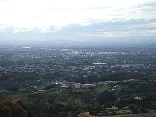
Hastings District is a Territorial authority district within the Hawke's Bay Region, on the east coast of the North Island of New Zealand. It covers the southern half of the Hawke's Bay coast, excluding Napier City, which is a separate territorial authority. Hastings District Council is headquartered in the city of Hastings, the district's largest town.
Leigh is a small coastal community in the north of the Auckland Region of New Zealand. It lies on the west side of Omaha Cove, a small inlet within Ōmaha Bay to the south of Cape Rodney. It is 13 km from Matakana, 21 km from Warkworth and approximately 92 km north of Auckland City.

Haumoana is a coastal town just south of the Tukituki River outlet in Hawke Bay on the east coast of New Zealand's North Island. It is located 12 km south of Napier and ten kilometres east of Hastings. The village incorporates a school, a Presbyterian Church, a general store, a takeaway shop, a hall and a fire station. The village was developed as a holiday settlement with beaches, and the surrounding area has historically been used for sheep and cattle grazing and horticulture. However, lifestyle blocks and grape growing have become more prominent in recent times. Many inhabitants commute to the nearby cities to work. There are approximately 430 houses in Haumoana. The population at the 2013 census was 2256, an increase of 54 people since 2006.
Whirinaki is a small coastal settlement in Hawke's Bay, in the eastern North Island of New Zealand. It sits just north of the mouth of the Esk River, a few kilometres north of Bay View and a similar distance east of Eskdale. It lies on State Highway 2, just north of its junction with State Highway 5.

Frasertown is a small settlement in the northern Hawke's Bay Region of New Zealand's eastern North Island.

Wharekahika or Hicks Bay is a bay and coastal area in the Gisborne District of the North Island of New Zealand. It is situated 150 km east of Ōpōtiki and 186 km north of Gisborne city, along State Highway 35 between Potaka and Te Araroa.

Gisborne District or the Gisborne Region is a local government area of northeastern New Zealand. It is governed by Gisborne District Council, a unitary authority. It is named after its largest settlement, the city of Gisborne. The region is also commonly referred to as the East Coast.

Wairoa District is a territorial authority district within the Hawke's Bay Region in the North Island of New Zealand. The Wairoa District Council is headquartered in the largest town, Wairoa. The district covers the northern half of the Hawke's Bay coast, extending from Māhia Peninsula to Lake Waikaremoana, and south to the mouth of the Waikare River.

Ongaonga is a village in Central Hawkes Bay District of New Zealand's North Island. It is located 20 kilometres west of Waipawa and a similar distance from Waipukurau.
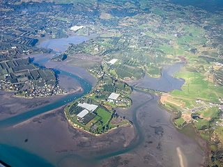
Whakatu is a rural community in the Hastings District and Hawke's Bay Region of New Zealand's North Island. It is located 8 kilometres (5.0 mi) north-east of the centre of Hastings. A large industrial area is enclosed by a bend in the Clive River, and the closure of the freezing works in Whakatu in 1986 cost the region 2000 full-time and seasonal jobs. State Highway 2 and the Palmerston North–Gisborne Line pass through Whakatu.
Ruby Bay is a settlement in the Tasman District of New Zealand's upper South Island. It is located between Māpua and Tasman on Te Mamaku / Ruby Bay. Ruby Bay was named after small 'rubies' found within the moutere gravel.

Thornton Bay is a settlement on the west coast of the Coromandel Peninsula of New Zealand, between Te Puru to the north and Whakatete Bay to the south. State Highway 25 runs through it. Ngarimu Bay immediately to the south is considered to be part of the same urban area by Statistics New Zealand.
Plummers Point is a rural settlement in the Western Bay of Plenty District and Bay of Plenty Region of New Zealand's North Island. It is on a headland on the southern side of Tauranga Harbour, opposite Motuhoa Island, and between Mangawhai Bay and Te Puna Estuary. The East Coast Main Trunk forms its southern boundary.

Ōhiwa is a rural settlement in the Ōpōtiki District and Bay of Plenty Region of New Zealand's North Island. It is on a headland on the eastern side of Ōhiwa Harbour, and on the western side of the Waiotahe River mouth.

