The district's population in June 2023 was 26,000,[2] of whom 55.8% lived in Tokoroa. Putaruru's population was 4,600. The region's population decreased markedly during the 1990s, dropping over 4000 since the 1991 census.
Ngāti Raukawa[3] is the Maori tribe of the area and goes back 20–25 generations. There are 32 marae in the district, Papa te Aroha marae (Catholic Community), Aotearoa marae, Pikitu marae (Nga-Huri), Pōhara marae (Ngati Koroki), Whakaaratamaiti marae (Ngati Mahana), Mangakaretu marae (Ngati Ahuru), Ngatira marae (Ngati Ahuru), Tarukenga marae (Ngati Te-Ngakau), Mokai marae (Ngati Te Kohera), Ongaroto marae (Ngati Whaita), Paparamu marae (Ngati Te Apunga), Te Ruapeka marae (Ngati Tukorehe), among others
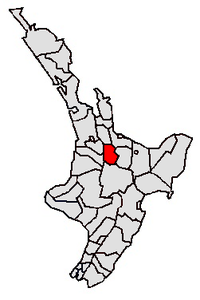
South Waikato District covers 1,818.88km2 (702.27sqmi)[1] and had an estimated population of 26,000 as of June 2023,[2] with a population density of 14.3 people per km2.
South Waikato District had a population of 25,044 in the 2023 New Zealand census, an increase of 1,002 people (4.2%) since the 2018 census, and an increase of 2,973 people (13.5%) since the 2013 census. There were 9,954 dwellings. There were 5,637 people (22.5%) aged under 15 years, 4,467 (17.8%) aged 15 to 29, 10,614 (42.4%) aged 30 to 64, and 4,326 (17.3%) aged 65 or older.[5]
Ethnicities were 69.0% European/Pākehā, 38.3% Māori, 13.5% Pasifika, 5.0% Asian, 0.3% Middle Eastern, Latin American and African New Zealanders, and 1.0% other. People may identify with more than one ethnicity.[5]
South Waikato District had a population of 24,042 at the 2018 New Zealand census. There were 8,511 households, comprising 11,982 males and 12,060 females, giving a sex ratio of 0.99 males per female. The median age was 37.9 years (compared with 37.4 years nationally).
The percentage of people born overseas was 13.5, compared with 27.1% nationally.
Although some people chose not to answer the census's question about religious affiliation, 50.7% had no religion, 35.2% were Christian, 3.0% had Māori religious beliefs, 0.6% were Hindu, 0.3% were Muslim, 0.4% were Buddhist and 1.6% had other religions.
Of those at least 15 years old, 1,722 (9.3%) people had a bachelor's or higher degree, and 5,100 (27.5%) people had no formal qualifications. The median income was $24,900, compared with $31,800 nationally. 2,238 people (12.1%) earned over $70,000 compared to 17.2% nationally. The employment status of those at least 15 was that 8,259 (44.6%) people were employed full-time, 2,541 (13.7%) were part-time, and 1,164 (6.3%) were unemployed.[4]
Individual wards
Name
Area (km2)
Population
Density (per km2)
Households
Median age
Median income
Tirau Ward
293.10
2,334
7.96
870
36.7 years
$36,800
Putaruru Ward
562.61
6,687
11.89
2,466
40.8 years
$26,700
Tokoroa Ward
963.17
15,021
15.60
5,178
36.7 years
$23,300
New Zealand
37.4 years
$31,800
Economy
The district's main industries are forestry and timber production, however land previously in plantation forest is increasingly being converted to dairy production. Several hydroelectric projects are located at the district's western edge.
Bent St. Skate Park
One of South Waikato District's most prominent features is the historical skate-bowl park. It was built in the 1980s, as one of the first skate parks in the country, and was recently chosen for a major refurbishment project. This community-led project is set to receive $550,000 from the South Waikato District Council in order to facilitate its upgrade. Intended upgrades include additional skating features, court area, and seating area. [6]
Related Research Articles
Tuakau is a town in the Waikato region at the foot of the Bombay Hills, formerly part of the Franklin District until 2010, when it became part of Waikato District in the North Island of New Zealand. The town serves to support local farming, and is the residence of many employees of New Zealand Steel at Glenbrook.
Tokoroa is the fifth-largest town in the Waikato region of the North Island of New Zealand and largest settlement in the South Waikato District. Located 30 km southwest of Rotorua and 20 km south of Putāruru, close to the foot of the Mamaku Ranges, it is midway between Taupō and Hamilton on State Highway 1.
Tīrau is a small town in the Waikato region of the North Island of New Zealand, 50 kilometres southeast of Hamilton. The town has a population of 804. In the Māori language, "Tīrau" means "place of many cabbage trees."
Ngongotahā is a small settlement on the western shores of Lake Rotorua in the North Island of New Zealand. It is located 10 km (6.2 mi) northwest of the Rotorua central business district, and is considered as a suburb of Rotorua. It is part of the Rotorua functional urban area as defined by Statistics New Zealand. Ngongotahā has a population of 5,230 as of June 2023.
Kawhia Harbour is one of three large natural inlets in the Tasman Sea coast of the Waikato region of New Zealand's North Island. It is located to the south of Raglan Harbour, Ruapuke and Aotea Harbour, 40 kilometres southwest of Hamilton. Kawhia is part of the Ōtorohanga District and is in the King Country. It has a high-tide area of 68 km2 (26 sq mi) and a low-tide area of 18 km2 (6.9 sq mi). Te Motu Island is located in the harbour.
Putāruru is a small town in the South Waikato District and the Waikato region of New Zealand's North Island. It lies on the western side of the Mamaku Ranges and in the upper basin of the Waihou River. It is on the Oraka Stream 65 kilometres south-east of Hamilton. State Highway 1 and the Kinleith Branch railway run through the town.
Mangakino is a small town on the banks of the Waikato River in the North Island of New Zealand. It is located close to the hydroelectric power station at Lake Maraetai, 85 kilometres (53 mi) southeast of Hamilton. The town and its infrastructure are administered as the Mangakino Pouakani ward by the Taupō District Council.
Ōpunake is a small town on the southwest coast of Taranaki in New Zealand's North Island. It is located 45 kilometres southwest of New Plymouth. Rahotu is 16 km to the northwest. Manaia is 29 km to the southeast. State Highway 45 passes through the town. The town has a population of 1,440.
Ātiamuri is a former hydro village in the central North Island of New Zealand. It lies alongside State Highway 1 about 27 km south of Tokoroa and 38 km north of Taupō. It is bordered by the Waikato River and surrounded by pine plantations. Upper Ātiamuri, just north of the Waikato River, is a small community of lifestyle blocks, dairy farms and farm servicing businesses.
Arapuni is a rural town centre on the Waikato river in the South Waikato District of New Zealand. The town sits next to the Arapuni Dam, a hydroelectric dam at Lake Arapuni commissioned in 1929. The Arapuni Power Station consists of eight turbines which give a total output of 196 MW, the largest of the power stations on the Waikato river. The Arapuni hydro station is owned and operated by Mercury Energy.
Te Teko is a small inland town along the banks of the Rangitaiki River in the Bay of Plenty region of New Zealand's North Island.
Ngāti Raukawa is a Māori iwi with traditional bases in the Waikato, Taupō and Manawatu/Horowhenua regions of New Zealand. In 2006, 29,418 Māori registered their affiliation with Ngāti Raukawa.
Taupiri is a small town of about 500 people on the eastern bank of the Waikato River in the Waikato District of New Zealand. It is overlooked by Taupiri mountain, the sacred burial ground for the Waikato tribes of the Māori people, located just to the north.
Nūhaka is a small settlement in the northern Hawke's Bay Region of New Zealand's eastern North Island, lying on State Highway 2 between Wairoa and Gisborne. The road to Mahia turns off the highway at Nūhaka.
Te Araroa is a town in the Gisborne Region of the North Island of New Zealand. It is situated 175 km north of Gisborne city, along State Highway 35 between Tokata and Awatere. Te Araroa is the birthplace of noted Māori politician Sir Āpirana Ngata. Māori in the area are generally associated with the Ngāti Porou iwi. It is 100 metres from its local beach.
Manakau is a settlement situated in the Horowhenua District, located at the boundary of the Manawatū-Whanganui and Wellington regions of New Zealand's North Island. It lies 8 km north of Ōtaki and 12 km south of Levin, and is connected to both via State Highway 1, which skirts Manakau's western edge. The township is situated 5 km inland from the coast of the Tasman Sea.
Hokio Beach or Hōkio is a village and rural community in the Horowhenua District and Manawatū-Whanganui region of New Zealand's North Island.
Rotoiti is a settlement on the shore of Lake Rotoiti, in Rotorua Lakes within the Bay of Plenty Region of New Zealand's North Island.
Mourea is a settlement in Rotorua Lakes within the Bay of Plenty Region of New Zealand's North Island.
Tauranga Taupō is a semi-rural area located at the mouth of Tauranga Taupō River, on the southern shores of Lake Taupō in New Zealand's North Island.
This page is based on this Wikipedia article Text is available under the CC BY-SA 4.0 license; additional terms may apply. Images, videos and audio are available under their respective licenses.