
Lake Taupō is a large crater lake in New Zealand's North Island, located in the caldera of Taupō Volcano. The lake is the namesake of the town of Taupō, which sits on a bay in the lake's northeastern shore. With a surface area of 616 km2 (238 sq mi), it is the largest lake by surface area in New Zealand, and the second largest freshwater lake by surface area in geopolitical Oceania after Lake Murray in Papua New Guinea. Motutaiko Island lies in the southeastern area of the lake.

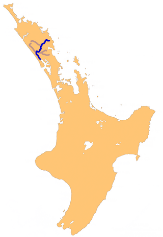
The Waikato River is the longest river in New Zealand, running for 425 kilometres (264 mi) through the North Island. It rises on the eastern slopes of Mount Ruapehu, joining the Tongariro River system and flowing through Lake Taupō, New Zealand's largest lake. It then drains Taupō at the lake's northeastern edge, creates the Huka Falls, and flows northwest through the Waikato Plains. It empties into the Tasman Sea south of Auckland, at Port Waikato. It gives its name to the Waikato region that surrounds the Waikato Plains. The present course of the river was largely formed about 17,000 years ago. Contributing factors were climate warming, forest being reestablished in the river headwaters and the deepening, rather than widening, of the existing river channel. The channel was gradually eroded as far up river as Piarere, leaving the old Hinuera channel through the Hinuera Gap high and dry. The remains of the old course are seen clearly at Hinuera, where the cliffs mark the ancient river edges. The Waikato's main tributary is the Waipā River, which converges with it at Ngāruawāhia.

Lake Rotokākahi or Green Lake, is one of four small lakes lying between Lake Rotorua and Lake Tarawera in the Bay of Plenty Region of New Zealand's North Island. The others are Lake Tikitapu, Lake Ōkāreka, and Lake Ōkataina. All lie within the Ōkataina Caldera, along its western edge.

Lake Wairarapa is a lake at the southern end of the North Island of New Zealand, 50 kilometres (31 mi) east of Wellington. The lake covers an area of 78 km2 (30 sq mi), and at its deepest is 2.5 m (8.2 ft). It is the third largest in the North Island, fractionally smaller than Lake Rotorua. The nearest town to the lake is Featherston, which is located five kilometres from its northern shore.

The Ruamahanga River runs through the southeastern North Island of New Zealand.

The Wairoa River, also known as Wairoa South, is the second longest river in the Auckland Region of New Zealand's North Island. It flows north from its sources in the Hunua Ranges into the Hauraki Gulf, and passes adjacent to the township of Clevedon. The Hunua Falls form a section of the river.

New Zealand has several notable wetlands but 90% of wetland areas have been lost following European settlement.
The Kumengamatea River is a river of the Northland Region of New Zealand's North Island. It flows southwest into the Awaroa River close to the latter's outflow into the Wairoa River.

The Pakoka River is a river of the Waikato Region of New Zealand's North Island. It flows southwest from its source southeast of Raglan to reach the northeastern end of the Aotea Harbour. The catchment is made up of just over 86 kilometres (53 mi) of waterways.
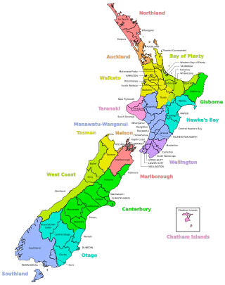
A district in New Zealand is a territorial authority area governed by a district council as a second-tier of local government in New Zealand, below regional councils. They were formed as a result of the local government reforms in 1989. There are 53 districts in New Zealand, and they do not include the 12 city councils, the Auckland Council, and the Chatham Islands Council. District councils serve a combination of rural and urban communities, while city councils administer the larger urban areas. Three districts are unitary authorities also performing the functions of a regional council.

Water is relatively abundant in New Zealand due to the temperate climate and maritime weather patterns. In recent years, water pollution and draw-down of aquifers have become important environmental issues in New Zealand.

The Glen Afton Branch was a branch railway line of 7.9 km in the Waikato in New Zealand, built to serve coal mines in the Awaroa district west of Huntly at Rotowaro, Pukemiro and Glen Afton. Rotowaro is Māori for "coal lake".
The Awaroa River is a short river in the Waikato District of New Zealand's North Island. It flows east from its source in the dunes near Karioitahi Beach and Lake Puketi, then south from Waiuku joining with the Aka Aka Stream before reaching the Waikato River in its tidal reaches close to Motutieke Island.
Lake Whangape is shallow, supertrophic, lateral and the second largest lake in the lower Waikato River basin in New Zealand. One source said the name translated to 'a large sheet of water', another that it was a chief's name.

The Awaroa River is a river in the Ōtorohanga District on the west coast of New Zealand's North Island. It flows north from its source near Te Koraha through Hauturu to Kawhia Harbour. The river passes through both pasture and indigenous forest. Over half of the river is in forest.
Kokotau is a rural locality and a statistical area in the Carterton District and Wellington Region of New Zealand's North Island. The locality is about 8 km southeast of Carterton by road, and the statistical area covers the district east of Carterton to the Ruamahanga and Waingawa rivers.
The Awakino River is a river of the Kaipara District in Northland Region. It flows 38 km (24 mi), generally south from the Awakino Stream, which rises on the Tutāmoe Range, to reach the Wairoa River on the eastern edge of Dargaville. The river is crossed by SH14 and the mothballed Dargaville Branch railway.
Awakino River may refer to several Rivers in New Zealand:

Portages in New Zealand, known in Māori as Tō or Tōanga Waka, are locations where waka (canoes) could easily be transported overland. Portages were extremely important for early Māori, especially along the narrow Tāmaki isthmus of modern-day Auckland, as they served as crucial transportation and trade links between the east and west coasts. Portages can be found across New Zealand, especially in the narrow Northland and Auckland regions, and the rivers of the Waikato Region.