
Smart growth is an urban planning and transportation theory that concentrates growth in compact walkable urban centers to avoid sprawl. It also advocates compact, transit-oriented, walkable, bicycle-friendly land use, including neighborhood schools, complete streets, and mixed-use development with a range of housing choices. The term "smart growth" is particularly used in North America. In Europe and particularly the UK, the terms "compact city", "urban densification" or "urban intensification" have often been used to describe similar concepts, which have influenced government planning policies in the UK, the Netherlands and several other European countries.
A green belt is a policy, and land-use zone designation used in land-use planning to retain areas of largely undeveloped, wild, or agricultural land surrounding or neighboring urban areas. Similar concepts are greenways or green wedges, which have a linear character and may run through an urban area instead of around it. In essence, a green belt is an invisible line designating a border around a certain area, preventing development of the area and allowing wildlife to return and be established.

Lake Sammamish is a freshwater lake 8 miles (13 km) east of Seattle in King County, Washington, United States. The lake is 7 miles (11 km) long and 1.5 miles (2 km) wide, with a maximum depth of 105 feet (32 m) and a surface area of 8 sq mi (21 km2). It lies east of Lake Washington and west of the Sammamish Plateau, and stretches from Issaquah in the south to Redmond in the north. At Issaquah it is fed by Issaquah Creek, and at Redmond it drains to Lake Washington via the Sammamish River, named after the native people who once lived along its entire length.

Urban renewal is a program of land redevelopment often used to address urban decay in cities. Urban renewal involves the clearing out of blighted areas in inner cities in favour of new housing, businesses, and other developments.

The Champaign–Urbana metropolitan area, also known as Champaign–Urbana and Urbana–Champaign as well as Chambana (colloquially), is a metropolitan area in east-central Illinois. As defined by the Office of Management and Budget (OMB), the metropolitan area has a population of 235,608 as of the 2023 U.S. Census Bureau estimate, which ranks it as the 201st largest metropolitan statistical area in the U.S. The area is anchored by the principal cities of Champaign and Urbana, and is home to the University of Illinois Urbana-Champaign, the flagship campus of the University of Illinois system.

Urban sprawl is defined as "the spreading of urban developments on undeveloped land near a more or less densely populated city". Urban sprawl has been described as the unrestricted growth in many urban areas of housing, commercial development, and roads over large expanses of land, with little concern for very dense urban planning. Sometimes the urban areas described as the most "sprawling" are the most densely populated. In addition to describing a special form of urbanization, the term also relates to the social and environmental consequences associated with this development. In modern times some suburban areas described as "sprawl" have less detached housing and higher density than the nearby core city. Medieval suburbs suffered from the loss of protection of city walls, before the advent of industrial warfare. Modern disadvantages and costs include increased travel time, transport costs, pollution, and destruction of the countryside. The revenue for building and maintaining urban infrastructure in these areas are gained mostly through property and sales taxes. Most jobs in the US are now located in suburbs generating much of the revenue, although a lack of growth will require higher tax rates.
Middlesex Centre is a township in Middlesex County, in southwestern Ontario, Canada, north and west of London. The Corporation of the Township of Middlesex Centre formed on January 1, 1998, with the amalgamation of the former Townships of Delaware, Lobo, and London. It is part of the London census metropolitan area.

Suburbanization, also spelled suburbanisation, is a population shift from historic core cities or rural areas into suburbs. Most suburbs are built in a formation of (sub)urban sprawl. As a consequence of the movement of households and businesses away from city centers, low-density, peripheral urban areas grow. Proponents of curbing suburbanization argue that sprawl leads to urban decay and a concentration of lower-income residents in the inner city, in addition to environmental harm.

A dead mall, also known as a ghost mall or zombie mall, is a shopping mall that has low consumer traffic or is deteriorating in some manner.
A planned unit development (PUD) is a type of flexible, non-Euclidean zoning device that redefines the land uses allowed within a stated land area. PUDs consist of unitary site plans that promote the creation of open spaces, mixed-use housing and land uses, environmental preservation and sustainability, and development flexibility. Areas rezoned as PUDs include building developments, designed groupings of both varied and compatible land uses—such as housing, recreation, commercial centers, and industrial parks—within one contained development or subdivision. Developed areas vary in size and by zoned uses, such as industrial, commercial, and residential. Other types of similar zoning devices include floating zones, overlay zones, special district zoning, performance-based codes, and transferable development rights.

In urban planning, infill, or in-fill, is the rededication of land in an urban environment, usually open-space, to new construction. Infill also applies, within an urban polity, to construction on any undeveloped land that is not on the urban margin. The slightly broader term "land recycling" is sometimes used instead. Infill has been promoted as an economical use of existing infrastructure and a remedy for urban sprawl. Detractors view increased urban density as overloading urban services, including increased traffic congestion and pollution, and decreasing urban green-space. Many also dislike it for social and historical reasons, partly due to its unproven effects and its similarity with gentrification.

Commercial areas, commercial districts or commercial zones in a city are areas, districts, or neighborhoods primarily composed of commercial buildings, such as a strip mall, office parks, downtown, central business district, financial district, "Main Street", or shopping centers. Commercial activity within cities includes the buying and selling of goods and services in retail businesses, wholesale buying and selling, financial establishments, and a wide variety of uses that are broadly classified as "business." While commercial activities typically take up a relatively small amount of land, they are extremely important to a community's economy. They provide employment, facilitate the circulation of money, and often serve many other roles important to the community, such as public gathering and cultural events.

Mixed use is a type of urban development, urban design, urban planning and/or a zoning classification that blends multiple uses, such as residential, commercial, cultural, institutional, or entertainment, into one space, where those functions are to some degree physically and functionally integrated, and that provides pedestrian connections. Mixed-use development may be applied to a single building, a block or neighborhood, or in zoning policy across an entire city or other administrative unit. These projects may be completed by a private developer, (quasi-)governmental agency, or a combination thereof. A mixed-use development may be a new construction, reuse of an existing building or brownfield site, or a combination.
A sustainable city, eco-city, or green city is a city designed with consideration for the social, economic, and environmental impact, as well as a resilient habitat for existing populations. This is done in a way that does not compromise the ability of future generations to experience the same. The UN Sustainable Development Goal 11 defines sustainable cities as those that are dedicated to achieving green sustainability, social sustainability and economic sustainability. In accordance with the UN Sustainable Development Goal 11, a sustainable city is defined as one that is dedicated to achieving green, social, and economic sustainability. They are committed to this objective by facilitating opportunities for all through a design that prioritizes inclusivity as well as maintaining a sustainable economic growth. Furthermore, the objective is to minimize the inputs of energy, water, and food, and to drastically reduce waste, as well as the outputs of heat, air pollution. Richard Register, a visual artist, first coined the term ecocity in his 1987 book Ecocity Berkeley: Building Cities for a Healthy Future, where he offers innovative city planning solutions that would work anywhere. Other leading figures who envisioned sustainable cities are architect Paul F Downton, who later founded the company Ecopolis Pty Ltd, as well as authors Timothy Beatley and Steffen Lehmann, who have written extensively on the subject. The field of industrial ecology is sometimes used in planning these cities.
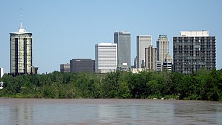
Tulsa is the second-largest city in the state of Oklahoma. It has many diverse neighborhoods due to its size.

Green infrastructure or blue-green infrastructure refers to a network that provides the “ingredients” for solving urban and climatic challenges by building with nature. The main components of this approach include stormwater management, climate adaptation, the reduction of heat stress, increasing biodiversity, food production, better air quality, sustainable energy production, clean water, and healthy soils, as well as more human centered functions, such as increased quality of life through recreation and the provision of shade and shelter in and around towns and cities. Green infrastructure also serves to provide an ecological framework for social, economic, and environmental health of the surroundings. More recently scholars and activists have also called for green infrastructure that promotes social inclusion and equity rather than reinforcing pre-existing structures of unequal access to nature-based services.

Medium-density housing is a term used within urban planning and academic literature to refer to a category of residential development that falls between detached suburban housing and large multi-story buildings. There is no singular definition of medium-density housing as its precise definition tends to vary between jurisdiction. Scholars however, have found that medium density housing ranges from about 25 to 80 dwellings per hectare, although most commonly sits around 30 and 40 dwellings/hectare. Typical examples of medium-density housing include duplexes, triplexes, townhouses, row homes, detached homes with garden suites, and walk-up apartment buildings.

Land recycling is the reuse of abandoned, vacant, or underused properties for redevelopment or repurposing.

A commuter town is a populated area that is primarily residential rather than commercial or industrial. Routine travel from home to work and back is called commuting, which is where the term comes from. A commuter town may be called by many other terms: "bedroom community", "bedroom town", "bedroom suburb" (US), "dormitory town" (UK). The term "exurb" was used from the 1950s, but since 2006, is generally used for areas beyond suburbs and specifically less densely built than the suburbs to which the exurbs' residents commute.
Innovation districts are urban geographies of innovation where research and development (R&D) strong institutions, companies, and other private actors develop integrated strategies and solutions to develop thriving innovation ecosystems–areas that attract entrepreneurs, startups, and business incubators. Unlike science parks, innovation districts are physically compact, leverage density and high levels of accessibility, and provide a “mash up” of activities including housing, office, and neighborhood-serving amenities. Districts signify the collapse back of innovation into cities and is increasingly used as a way to revitalize the economies of cities and their broader regions. As of 2019, there are more than 100 districts worldwide.
