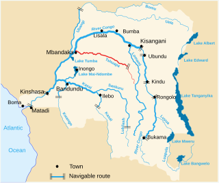
Location
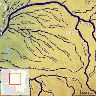
The Busira River forms a few miles west of Boende where the Lomela River joins the Tshuapa River from the left. The Busira receives the Salonga River 2 kilometres (1.2 mi) upstream from Lotoko. The Momboyo River joins the Busira River from the left to form the Ruki River above Ingende. The Busira is 305 kilometres (190 mi) long, and the whole Ruki-Busira waterway is 408 kilometres (254 mi) long.
The Ruki–Busira can be navigated year round, since the depth is always more than 1 metre (3 ft 3 in) and reaches 2 metres (6 ft 7 in) in the flood period. High water is in March-April and November. Low water is in February and June-July. Villages along the Busira River include Lingunda, Boleke, Bokote and Loolo. These have markets for wild animals and for forest products from the nearby Salonga National Park. They are the main source of bushmeat in the markets of Mbandaka, where the Ruki River joins the Congo River.
Environment
The Busira forms in the heart of the central depression of the Congo Basin. Rainfall here averages 2,000 millimetres (79 in) annually, with no dry season. The Tshuapa and Lomela tributaries both run through wide belts of swampland. There are swamps on the Busira and Momboyo before they join to form the Ruki. Swamps cover 55,000 hectares (140,000 acres) on the Busira between 19°00'E and 19°27'E. The Busira River feeds the Mbandaka flooded forests, and floods 925 square kilometres (357 sq mi).
Edaphic savannas, small herbaceous clearings on sandy, or loamy to clayey soil, are found beside the channels of the Busira River. They are separated from the river by a strip of gallery forest. They form on old sandbanks or dried out lagoons left behind when the river changed course. The vegetation is dominated by Hyparrhenia diplandra . The savannas are transitional and gradually disappear as they are invaded by the forest.
Colonial period
As of 1 January 1894 the Société anonyme belge pour le commerce du Haut-Congo (SAB) had 83 factories and posts, including some in the French territory to the west of the Congo and Ubangi rivers. A map shows the company had posts along the upper Ruki River at Bilakamba, Bombimba, Bussira Manene, Moniaca, Bocoté and Yolongo. It also had a post at Bomputu on the Lengué (Salonga) River, and posts at Balalondzy, Ivulu and Ivuku on the Momboyo River.
The Compagnie du Congo pour le Commerce et l'Industrie (CCCI) was given the right to 150,000 hectares (120,000 acres) of land in return for its services in studying the Matadi-Léopoldville Railway project. The Compagnie du chemin de fer du Congo (CFC) was given 1,500 hectares (3,700 acres) of land for every 1 kilometre (0.62 mi) of line put into operation, as well as a strip 200 metres (660 ft) wide along the railway. The CCCI and CFC lands were mostly grouped into the Bloc de la Busira-Momboyo , created in 1901, along the Busira and Momboyo rivers. This property of 1,041,373 hectares (2,573,290 acres) was exploited by the SAB. In 1904, in the last months before the concession was taken back by the state, the SAB harvested 50 tons of dry rubber, of which 6 were from Ikelemba, 34 from Busira and 10 from Salonga Lomela.
Sankuru Nature Reserve is a protected area in the Democratic Republic of the Congo. It was created in November 2007 to protect a forest area home to bonobo, okapi and African forest elephant. The reserve has not been managed effectively, and suffers from ongoing deforestation and bushmeat hunting.
The Tshuapa River or Rivière Tshwapa is a river in Democratic Republic of the Congo, the main tributary of the Busira River.
The Ruki is a river in the Democratic Republic of the Congo. It is a left tributary of the Congo River. It may be seen as the lower reach of the Busira River, which in turn may be seen as the lower reach of the Tshuapa River.
Bolomba Territory is an administrative area in Équateur Province in the Democratic Republic of the Congo. The headquarters is the town of Bolomba. It is located northeast of the provincial capital of Mbandaka. Its main waterway is the Ikelemba River which is navigable down to the Congo River.
The Compagnie Industrielle et de Transports au Stanley Pool (CITAS) was a Belgian company involved in transport on the Congo River between 1902 and 1955, in what was first the Congo Free State and then the Belgian Congo, today the Democratic Republic of the Congo. The company evolved from owning a shipyard in Léopoldville (now to providing transport services on the Congo, and then to running a port in Léopoldville.

The Compagnie du Congo pour le Commerce et l’Industrie (CCCI) was a major conglomerate active in the Congo Free State, Belgian Congo and later the Democratic Republic of the Congo where its subsidiary companies engaged in a wide range of activities in the Congo between 1887 and 1971. These included railway and river transport, mining, agriculture, banking, trading and so on. It was the largest commercial enterprise in the Congo for many years. It went through various mergers in the years that followed before its successor Finoutremer was liquidated in 2000.

The Société anonyme belge pour le commerce du Haut-Congo (SAB) was a private enterprise in the Congo Free State, later the Belgian Congo, that operated a string of trading stations in the Congo River basin, and exported ivory, rubber and other local products. The ruthless treatment of the local people by SAB agents inspired Joseph Conrad to write his 1899 novel Heart of Darkness.
The Ikelemba River is a river in the Democratic Republic of the Congo. It is a left tributary of the Congo River.

The Momboyo River is a river in the Democratic Republic of the Congo. It joins the Busira River to form the Ruki River, a tributary of the Congo River. The Momboya and its main tributary the Luilaka are navigable for 545 kilometres (339 mi) from its mouth.
The Lomela River is a river in the Democratic Republic of the Congo. It is one of the main tributaries of the Busira River, which forms where the Lomela meets the Tshuapa River. The Busira is in turn the main tributary of the Ruki River, which enters the Congo River to the north of Mbandaka.
The Salonga River is a river in the Democratic Republic of the Congo. It is a tributary of the Busira River.
Ingende is a town in the Province of Équateur in the Democratic Republic of the Congo, the headquarters of Ingende Territory.
Busira, or Busira Manene, is a village in the Province of Équateur in the Democratic Republic of the Congo, in Busira Territory.
Elinga-Mpango or Elingampango is a community in the Sankuru province of the Democratic Republic of the Congo.
Bokote is a community on the Busira River in the Province of Équateur in the Democratic Republic of the Congo. In the colonial period it held a trading post and a Catholic mission.
Lotoko is a community on the Busira River in the Province of Équateur in the Democratic Republic of the Congo. In the colonial period it held a trading post.
Monieka is a community on the Busira River in the Province of Équateur in the Democratic Republic of the Congo. In the colonial period it held a trading post and a Protestant mission.

The Bus Bloc, or Bloc de la Busira-Momboyo, was a huge concession in the Congo Free State, later the Belgian Congo, operated by the Société anonyme belge pour le commerce du Haut-Congo (SAB). It covered land along and between the Busira River and Momboyo River. In the early days the SAB exploited the local people ruthlessly in their demands for rubber, and many died.
Bomputu is a community on the Salonga River in the province of Tshuapa in the Democratic Republic of the Congo. In the colonial period it held a trading post.
This page is based on this
Wikipedia article Text is available under the
CC BY-SA 4.0 license; additional terms may apply.
Images, videos and audio are available under their respective licenses.
