
The Tumucumaque Mountains National Park is situated in the Amazon Rainforest in the Brazilian states of Amapá and Pará. It is bordered to the north by French Guiana and Suriname.

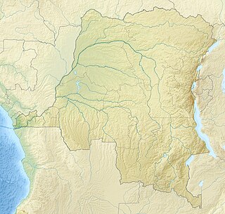
Virunga National Park is a national park in the Albertine Rift Valley in the eastern part of the Democratic Republic of the Congo. It was created in 1925 and is among the first protected areas in Africa. In elevation, it ranges from 680 m (2,230 ft) in the Semliki River valley to 5,109 m (16,762 ft) in the Rwenzori Mountains. From north to south it extends about 300 km (190 mi), largely along the international borders with Uganda and Rwanda in the east. It covers an area of 8,090 km2 (3,120 sq mi) and is listed in the List of World Heritage in Danger since 1994.

The Ili is a river situated in Northwest China and Southeastern Kazakhstan. It flows from the Ili Kazakh Autonomous Prefecture of the Xinjiang Uighur Autonomous Region to the Almaty Region in Kazakhstan.

Salonga National Park is a national park in the Democratic Republic of the Congo located in the Congo River basin. It is Africa's largest tropical rainforest reserve covering about 36,000 km2 or 3,600,000 hectares. It extends into the provinces of Mai Ndombe, Equateur, Kasaï and Sankuru.

The Natashquan is a river in the Canadian provinces of Quebec and Newfoundland and Labrador. It flows south into the Gulf of Saint Lawrence.
The Ruki is a river in the Democratic Republic of the Congo. It is a left tributary of the Congo River. It may be seen as the lower reach of the Busira River, which in turn may be seen as the lower reach of the Tshuapa River.
The Busira River is a river in the Democratic Republic of the Congo. It is the main tributary of the Ruki River, which in turn is a tributary of the Congo River. The Busira may be seen as the upper reach of the Ruki River. It is navigable year round.

The Amazon biome contains the Amazon rainforest, an area of tropical rainforest, and other ecoregions that cover most of the Amazon basin and some adjacent areas to the north and east. The biome contains blackwater and whitewater flooded forest, lowland and montane terra firme forest, bamboo and palm forest, savanna, sandy heath and alpine tundra. Some areas are threatened by deforestation for timber and to make way for pasture or soybean plantations.
The Itimbiri River is a right tributary of the Congo River, which it joins above Bumba. At one time it was important as a navigable waterway for transporting good from the northeast of the country down to the Congo.

The Rubi River is a left tributary of the Itimbiri River, which forms where the Rubi joins the Likati River.

The Réserve faunique des Chic-Chocs is a wildlife reserve of Quebec located in east of Parc national de la Gaspésie, in the administrative region of Gaspésie–Îles-de-la-Madeleine, in Quebec, Canada.

The parc national d'Opémican is a national park of Quebec (Canada) located south of Abitibi-Témiscamingue, between Laniel and Témiscaming. The park is 252 kilometres (156.59 mi) in size and was established on 19 December 2013. It ensures the protection of the characteristic landscape of the Southern Laurentians.
The Union Nationale des Transports Fluviaux (Unatra) was a government-controlled company that provided river transport services in the Belgian Congo between 1925 and 1936.
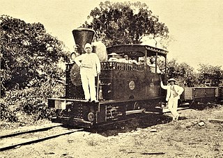
The Compagnie du chemin de fer du Congo supérieur aux Grands Lacs africains was a Belgian railway company established in 1902 in the Congo Free State, later the Belgian Congo, now the Democratic Republic of the Congo. It provided service in the eastern part of the colony south of Stanleyville (Kisangani) to serve the settlers and mining operations in Katanga. It operated a combination of river steamer service along the Lualaba River and railway links where the river was not navigable, including a link to Lake Tanganyika. In 1960 it became the Société congolaise des chemins de fer des Grands Lacs.
The Société anonyme belge pour le commerce du Haut-Congo (SAB) was a private enterprise in the Congo Free State, later the Belgian Congo, that operated a string of trading stations in the Congo River basin, and exported ivory, rubber and other local products. The ruthless treatment of the local people by SAB agents inspired Joseph Conrad to write his 1899 novel Heart of Darkness.
The Ikelemba River is a river in the Democratic Republic of the Congo. It is a left tributary of the Congo River.
The Momboyo River is a river in the Democratic Republic of the Congo. It joins the Busira River to form the Ruki River, a tributary of the Congo River. The Momboya and its main tributary the Luilaka are navigable for 545 kilometres (339 mi) from its mouth.
The Lomela River is a river in the Democratic Republic of the Congo. It is one of the main tributaries of the Busira River, which forms where the Lomela meets the Tshuapa River. The Busira is in turn the main tributary of the Ruki River, which enters the Congo River to the north of Mbandaka.
Ingende is a town in the Province of Équateur in the Democratic Republic of the Congo, the headquarters of Ingende Territory.
This page is based on this
Wikipedia article Text is available under the
CC BY-SA 4.0 license; additional terms may apply.
Images, videos and audio are available under their respective licenses.
