
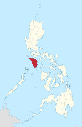
Occidental Mindoro, officially the Province of Occidental Mindoro, is a province in the Philippines located in the Mimaropa region. The province occupies the western half of the island of Mindoro. Its capital is Mamburao, but the most populous municipality is San Jose. Sablayan is its largest municipality in terms of area, occupying almost half of the entire province. As of 2020, Occidental Mindoro has 525,354 inhabitants.

Puerto Galera, officially the Municipality of Puerto Galera, is a 1st class municipality in the province of Oriental Mindoro, Philippines. According to the 2020 census, it has a population of 41,961 people.

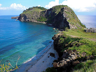
Lubang Island is the largest among the seven islands in the Lubang Group of Islands, an archipelago situated to the northwest of the northern tip of the island of Mindoro in the Philippines. It is positioned approximately 40 kilometers west of Calatagan, Batangas, or 117 kilometers southwest of Manila. The Lubang Group of Islands is under the jurisdiction of the province of Occidental Mindoro and divided into two municipalities. The principal settlement is the town of Lubang, located at the northwest section and about 11 kilometers northwest of Tilik Port. The southeastern portion of the Lubang Island falls within the municipality of Looc, which also operates a port in a different area, specifically in Barangay Agkawayan. Lubang Group of Islands stands as a distinct geographical entity isolated from any landmass, rendering it biologically unique and also endangered.

Concepcion, officially the Municipality of Concepcion, is a 6th class municipality in the province of Romblon, Philippines. The municipality is coextensive with Maestre de Campo Island, which is also known as Sibale Island. According to the 2020 census, it has a population of 3,561 people, making it the least populated town in the province.

Lubang, officially the Municipality of Lubang, is a 4th class municipality in the province of Occidental Mindoro, Philippines. According to the 2020 census, it has a population of 17,437 people.
Mindoro was an island province of the Philippines from 1902 to 1950, when it was split into two provinces, Occidental Mindoro and Oriental Mindoro. It was located on Mindoro island, Philippines.

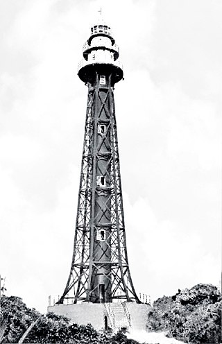
The Cabra Island Lighthouse is a historic lighthouse built on Cabra Island, the north-westernmost of the Lubang group of islands in Occidental Mindoro, Philippines. International vessels entering the Philippines from South China Sea were welcomed by the Cabra Light and directed either towards Manila Bay or the center of the archipelago through Verde Island Passage, one of busiest sea routes of the Philippines.
The Apo Reef Light was a historic lighthouse built on Bajo Apo Island in Apo Reef Natural Park. The park is located in the middle of Mindoro Strait, west of the province of Occidental Mindoro, in the Philippines. The station was established to warn ships of the dangerous shallow reefs in that part of the strait.
Bagatao Island Lighthouse is a historic lighthouse located on Bagatao Island on the eastern side of the entrance to Sorsogon Bay, in the province of Sorsogon in the Philippines. The 29-foot (8.8 m) white cylindrical iron tower is situated on the rocky headland that forms the southern point in the western end of the Island, giving the total light elevation of 135 feet (41 m). The light not only marks the entrance to the bay, but also assists ships in navigating the bend around Ticao Island of Masbate province as they head to San Bernardino Strait and exit to the Pacific Ocean.

Babuyan Island is the highest and northernmost island in the Babuyan Islands in Luzon Strait north of Luzon Island in the Philippines and also directly south of Taiwan via Bashi Channel to Luzon Strait. The whole island makes up the barangay of Babuyan Claro, that constitute the municipality of Calayan in Cagayan province. The volcanic island has a population of 1,910 as of the 2020 census, up from 1,423 in 2010.

Ilin Island is a small island in the Philippines. Measuring 47 square kilometres (18 sq mi), it is just south of Mindoro, separated by the Ilin Strait and Mangarin Bay. To the west is the smaller Ambulong Island, across the Ambulong Strait.
Capones Island, also known as Grand Capon or Capon Grande Island is a small island approximately 1.9 kilometers (1.2 mi) long by 0.4 kilometers (0.25 mi) wide, at its widest point, lying some 3.8 kilometers (2.4 mi) off the coast of the province of Zambales on western Luzon island in the Philippines. It is the largest of the Capones Islands, a group of three small islands which also includes nearby Camara Island and another islet connected to it by a sand bar. The island is administratively part of barangay Pundaquit of the Zambales municipality of San Antonio.

Cape Santiago is the southwestern point of the island of Luzon located within the municipality of Calatagan in Batangas, Philippines. It is a cape at the southern tip of Calatagan Peninsula which faces the South China Sea to the west and Pagapas Bay, an arm of Balayan Bay, to the east. The cape has been the site of a navigational aid since the 1890s.
Ambil is an island barangay in the Philippines that covers the island of the same name along with the two other smaller outlying islands of Mandaui and Malavatuan to the northeast. The barangay is administered as part of the municipality of Looc, Occidental Mindoro. The island, which is the 93rd largest island in the Philippines, was formed by a conical mountain that is around 2,461 feet (750 m) in height, Mount Benagongon.
Malavatuan or Malabatuan is a small island in the Philippines and part of the Lubang group of islands. It is around 3 miles (4.8 km) northeast of Ambil Island and is administered under the barangay of Ambil, in the municipality of Looc, Occidental Mindoro. In 1919 it was denoted as being covered in brushwood.
Mandaui is a small island in the Philippines and part of the Lubang group of islands. It is around .75 miles (1.21 km) northeast of Ambil Island and is administered under the barangay of Ambil, in the municipality of Looc, Occidental Mindoro. The island has two "small hills of uneven height."

Apo is an island located in the Apo Reef in Occidental Mindoro, Philippines. It is approximately 0.5 miles (0.80 km) in length.

Ambulong is a small island in the Philippines located on the western side of the Ambolon Strait, that separates it from Ilin Island. Ambulong is located in Occidental Mindoro province of the Philippines, part of the municipality of San Jose. In 1919 it was described as "hilly and well wooded", and in 1919 its elevation at the northern part of the island was recorded at 567 feet (173 m).

Jintotolo is an island within the Jintotolo Channel, part of the Province of Masbate, Philippines. It constitutes two barangays of the Municipality of Balud and has a population of 3,687 persons in the 2020 census.
Liwagao Island, also known as Libago Island or Libagao Island, is an island located southeast off the coast of Mindoro and northwest off Panay. The island is a disputed feature between the towns of Bulalacao, Oriental Mindoro and Caluya, Antique with the latter exercising de facto administration over the island.


