List of islands of the Philippines

Last updated

A map of the Philippines showing the island groups of Luzon, the Visayas, and Mindanao Federal states of the Philippines.png
A map of the Philippines showing the island groups of Luzon, the Visayas, and Mindanao

The Philippine Archipelago comprises about 7,641 islands [1] [2] clustered into three major island groups: Luzon, the Visayas, and Mindanao. Only about 2,000 islands are inhabited, [3] and more than 5,000 are yet to be officially named. [2]

Contents

List of islands by size

Below is a list of the largest Philippine islands. There are discrepancies in the area estimates across various sources, which would change the rankings of some smaller islands. The areas given may not be definitive.

The 50 largest islands have a combined area of around 321,000 square kilometers (124,000 sq mi) and a combined population of about 100.9 million (2015); thus they contain about 99% of the Philippines' total land area and total population (2015). Combined population of Luzon and Mindanao accounts for 80% of total population of the Philippines.

# [A] Name
of island
Area [4] Population Coordinates Notes
1 Luzon 109,965 km2
(42,458 sq mi)
64,260,312 15°59′59″N121°00′00″E / 15.9996°N 121.0000°E / 15.9996; 121.0000 (Luzon) 15th largest island and 4th most populated island in the world
2 Mindanao 97,530 km2
(37,657 sq mi)
25,537,691 7°41′42″N124°15′04″E / 7.695°N 124.251°E / 7.695; 124.251 (Mindanao) 19th largest island in the world
3 Samar 13,429 km2
(5,185 sq mi)
1,880,020 11°48′00″N125°00′43″E / 11.800°N 125.012°E / 11.800; 125.012 (Samar) [5] Largest island entirely within one region
4 Negros 13,310 km2
(5,139 sq mi)
4,414,131 10°01′34″N122°58′01″E / 10.026°N 122.967°E / 10.026; 122.967 (Negros) [5]
5 Palawan 12,189 km2
(4,706 sq mi)
886,308 9°30′00″N118°30′00″E / 9.5001°N 118.5000°E / 9.5001; 118.5000 (Palawan) Largest island entirely within one province
6 Panay 12,011 km2
(4,637 sq mi)
4,477,247 11°10′26″N122°30′14″E / 11.174°N 122.504°E / 11.174; 122.504 (Panay)
7 Mindoro 10,572 km2
(4,082 sq mi)
1,331,473 12°52′15″N120°55′40″E / 12.8707°N 120.9279°E / 12.8707; 120.9279 (Mindoro)
8 Leyte 7,368 km2
(2,845 sq mi)
2,388,518 10°50′01″N124°50′00″E / 10.8335°N 124.8333°E / 10.8335; 124.8333 (Leyte)
9 Cebu 4,468 km2
(1,725 sq mi)
3,917,423 10°19′42″N123°48′22″E / 10.3284°N 123.8060°E / 10.3284; 123.8060 (Cebu) Island province
10 Bohol 3,821 km2
(1,475 sq mi)
1,313,560 9°50′41″N124°12′49″E / 9.8447°N 124.2135°E / 9.8447; 124.2135 (Bohol) Island province
11 Masbate 3,268 km2
(1,262 sq mi)
706,897 12°15′01″N123°30′00″E / 12.2502°N 123.5000°E / 12.2502; 123.5000 (Masbate) Largest of island in Masbate province
12 Catanduanes 1,523 km2
(588 sq mi)
260,964 13°48′31″N124°13′24″E / 13.8086°N 124.2233°E / 13.8086; 124.2233 (Catanduanes) Island province
13 Basilan 1,265 km2
(488 sq mi)
459,367 6°35′28″N121°59′19″E / 6.5911°N 121.9885°E / 6.5911; 121.9885 (Basilan) Island province; largest island of the Sulu Archipelago
14 Marinduque 952 km2
(368 sq mi)
234,521 13°23′06″N121°58′52″E / 13.3850°N 121.9811°E / 13.3850; 121.9811 (Marinduque) Island province
15 Busuanga 890 km2
(344 sq mi)
73,849 12°08′42″N120°05′41″E / 12.1451°N 120.0948°E / 12.1451; 120.0948 (Busuanga) Largest of the Calamian Islands
16 Jolo 869 km2
(336 sq mi)
530,000 5°58′24″N121°09′00″E / 5.9732°N 121.1501°E / 5.9732; 121.1501 (Jolo) Part of the Sulu Archipelago
17 Tablas 839 km2
(324 sq mi)
164,012 12°24′20″N122°03′51″E / 12.4055°N 122.0642°E / 12.4055; 122.0642 (Tablas) [6]
18 Dinagat 802 km2
(310 sq mi)
106,951 10°13′30″N125°35′41″E / 10.2249°N 125.5947°E / 10.2249; 125.5947 (Dinagat) Island province [7]
19 Polillo 629 km2
(243 sq mi)
64,802 14°50′34″N121°55′45″E / 14.8428°N 121.9293°E / 14.8428; 121.9293 (Polillo)
20 Guimaras 605 km2
(234 sq mi)
174,613 10°34′47″N122°36′03″E / 10.5797°N 122.6007°E / 10.5797; 122.6007 (Guimaras) Island province
21 Tawitawi 581 km2
(224 sq mi)
82,582 5°11′52″N120°02′00″E / 5.1979°N 120.0333°E / 5.1979; 120.0333 (Tawitawi) Island province; part of the Sulu Archipelago
22 Biliran 536 km2
(207 sq mi)
171,612 11°35′01″N124°28′00″E / 11.5835°N 124.4667°E / 11.5835; 124.4667 (Biliran) Island province
23 Sibuyan 465 km2
(180 sq mi)
59,274 12°23′10″N122°33′40″E / 12.3862°N 122.5612°E / 12.3862; 122.5612 (Sibuyan)
24 Siargao 437 km2
(169 sq mi)
94,273 9°54′19″N126°04′00″E / 9.9052°N 126.0667°E / 9.9052; 126.0667 (Siargao)
25 Burias 424 km2
(164 sq mi)
90,300 12°52′54″N123°12′28″E / 12.8816°N 123.2078°E / 12.8816; 123.2078 (Burias)
26 Culion 389 km2
(150 sq mi)
20,139 11°49′09″N119°57′38″E / 11.8192°N 119.9606°E / 11.8192; 119.9606 (Culion) [8] 2nd largest of the Calamian Islands
27 Siquijor 337 km2
(130 sq mi)
95,984 9°11′51″N123°35′47″E / 9.1976°N 123.5964°E / 9.1976; 123.5964 (Siquijor) Island province
28 Ticao 334 km2
(129 sq mi)
95,129 12°30′58″N123°41′41″E / 12.5162°N 123.6947°E / 12.5162; 123.6947 (Ticao)
29 Dumaran 322 km2
(124 sq mi)
10°32′50″N119°52′23″E / 10.5471°N 119.8730°E / 10.5471; 119.8730 (Dumaran)
30 Balabac 319 km2
(123 sq mi)
7°56′32″N117°00′30″E / 7.9421°N 117.0083°E / 7.9421; 117.0083 (Balabac)
31 Samal 301 km2
(116 sq mi)
104,123 7°02′52″N125°44′39″E / 7.0479°N 125.7442°E / 7.0479; 125.7442 (Samal)
32 Sibutu 285 km2
(110 sq mi)
30,387 4°46′40″N119°28′35″E / 4.7779°N 119.4764°E / 4.7779; 119.4764 (Sibutu)
33 Camiguin 255 km2
(98 sq mi)
88,478 9°10′26″N124°42′34″E / 9.1740°N 124.7094°E / 9.1740; 124.7094 (Camiguin) Island province
34 Calayan 196 km2
(76 sq mi)
8,919 19°16′N121°29′E / 19.27°N 121.48°E / 19.27; 121.48 (Calayan) [9] Largest of the Babuyan Islands
35 Olutanga 194 km2
(75 sq mi)
87,078 7°22′00″N122°52′54″E / 7.3667°N 122.8817°E / 7.3667; 122.8817 (Olutanga)
36 Alabat 192 km2
(74 sq mi)
41,822 14°07′06″N122°03′05″E / 14.1184°N 122.0515°E / 14.1184; 122.0515 (Alabat)
37 Panaon 191 km2
(74 sq mi)
57,703 10°03′05″N125°12′45″E / 10.0513°N 125.2125°E / 10.0513; 125.2125 (Panaon)
38 Mapun 181 km2
(70 sq mi)
26,597 7°00′N118°30′E / 7.00°N 118.5°E / 7.00; 118.5 (Mapun) Formerly known as Cagayan de Tawi-tawi [10]
39 Camiguin 166 km2
(64 sq mi)
18°50′00″N121°51′36″E / 18.8333°N 121.86°E / 18.8333; 121.86 (Camiguin) [9] Part of the Babuyan Islands in Luzon, and distinct from Camiguin in Mindanao
40 Bucas Grande 128 km2
(49 sq mi)
22,314 9°40′26″N125°56′55″E / 9.6738°N 125.9486°E / 9.6738; 125.9486 (Bucas Grande)
Lubang 125 km2
(48 sq mi)
28,922 13°46′03″N120°11′10″E / 13.7675°N 120.186111°E / 13.7675; 120.186111 (Lubang)
Linapacan 120 km2
(46 sq mi)
15,668 11°30′N119°54′E / 11.5°N 119.9°E / 11.5; 119.9 (Linapacan) Largest island in the group of islands in Linapacan Strait. [11]
Bugsuk 119 km2
(46 sq mi)
8°15′15″N117°18′29″E / 8.2542°N 117.3081°E / 8.2542; 117.3081 (Bugsuk)
Bantayan 108 km2
(42 sq mi)
120,447 11°13′07″N123°44′55″E / 11.2187°N 123.7487°E / 11.2187; 123.7487 (Bantayan)
Pacijan 106 km2
(41 sq mi)
10°40′N124°20′E / 10.66°N 124.33°E / 10.66; 124.33 (Pacijan) Part of Camotes Islands group
Homonhon 105 km2
(41 sq mi)
4,211 10°45′21″N125°44′21″E / 10.7558°N 125.7393°E / 10.7558; 125.7393 (Homonhon)
Babuyan Claro 100 km2
(39 sq mi)
1,423 19°31′20″N121°57′13″E / 19.5222°N 121.9536°E / 19.5222; 121.9536 (Camiguin) [9] Part of the Babuyan Islands
Poro 96 km2
(37 sq mi)
36,508 10°40′20″N124°27′22″E / 10.6721°N 124.4560°E / 10.6721; 124.4560 (Poro) Part of Camotes Islands group
Patnanongan 92 km2
(36 sq mi)
14,606 14°47′01″N122°10′40″E / 14.7835°N 122.1779°E / 14.7835; 122.1779 (Patnanongan)
Panglao 91 km2
(35 sq mi)
79,216 9°36′N123°49′E / 9.6°N 123.82°E / 9.6; 123.82 (Panglao) [12]
Pangutaran 90 km2
(35 sq mi)
30,613 6°16′41″N120°32′52″E / 6.2780°N 120.5477°E / 6.2780; 120.5477 (Pangutaran)
A. ^ Rankings only provided for the first 40 largest islands. The list is incomplete, missing some islands with unknown or unreliable areas, making the rankings for smaller islands uncertain.

The following list breaks the islands down further by region and smaller island group for easier reference.

Luzon

Babuyan group

Bacuit group

Boats at Cadlao Island Cadlao2.jpg
Boats at Cadlao Island

Batanes group

White sand beach at Sabtang island Sabtang Island, Batanes.JPG
White sand beach at Sabtang island

Bicol region

A view from Tinaga beach in Tinaga at sunset Stunning view (803550746).jpg
A view from Tinaga beach in Tinaga at sunset
Cauit Island overlooking from Cagsao, Calabanga, Camarines Sur Kawit Island, Calabanga, Camarines Sur.jpg
Cauit Island overlooking from Cagsao, Calabanga, Camarines Sur

Cagayan Valley

The Cape Engano Lighthouse at Cape Engano, Palaui Island Faro de Cabo Engano Lighthouse.jpg
The Cape Engaño Lighthouse at Cape Engaño, Palaui Island

Calamian Islands

Catanduanes

Central Luzon

Grande Island Grande Island.JPEG
Grande Island

Cuyo Archipelago

Manamoc Island as seen from the north ManamocIsland.JPG
Manamoc Island as seen from the north
The main beach on the southern shore of Pamalican PamalicanMainBeach.JPG
The main beach on the southern shore of Pamalican

Ilocos Region

Manila Bay islands

A 1941 map of Corregidor Island Map of Corregidor 1941.jpg
A 1941 map of Corregidor Island

Marinduque

Masbate

Metro Manila

A view of the southern side of Isla de Convalecencia from the Ayala Bridge over the Pasig River Convalencia Island on Pasig River in Manila.jpg
A view of the southern side of Isla de Convalecencia from the Ayala Bridge over the Pasig River

Mindoro

Palawan

Cape Melville Lighthouse on the southern point of Balabac Island, circa 1892 Cabo Melville Lighthouse 1892.JPG
Cape Melville Lighthouse on the southern point of Balabac Island, circa 1892
Satellite image of Second Thomas Shoal (Ayungin Shoal), an island of the Spratly Islands group in the South China Sea Second Thomas Shoal - 2014-02-28 - Landsat 8 - 15m.png
Satellite image of Second Thomas Shoal (Ayungin Shoal), an island of the Spratly Islands group in the South China Sea

Polillo Islands

An aerial view of Polillo Island Polillo Island.JPG
An aerial view of Polillo Island

Romblon

An aerial view of Sibuyan Island Sibuyan Island.JPG
An aerial view of Sibuyan Island

Southern Tagalog

Mindanao

Caraga

Central Mindanao

Davao Region

Dinagat Islands

Northern Mindanao

Siargao

Sulu Archipelago

Panguan Island, The last island of the Sulu Archipelago nearest the Philippine-Malaysian border Panguan Island.jpg
Panguan Island, The last island of the Sulu Archipelago nearest the Philippine-Malaysian border
Mardanas Island, officially known as Siluag Docking at Mardanas Island.jpg
Mardanas Island, officially known as Siluag
Panampangan Island, The island with the longest sandbar in the Philippines Panampangan Island.jpg
Panampangan Island, The island with the longest sandbar in the Philippines

Zamboanga Peninsula

Visayas

Biliran

Bohol

Cebu

An aerial view of Gato Island Gato Island.jpg
An aerial view of Gato Island
  • Biyagayag Islands (Daku and Diot)
  • Botique Island (or Botigues, Batquis)
  • Botong Island
  • Doong Island
  • Hilutungan Island (or Hilotongan, Lutungan)
  • Hilantagaan Island (or Jicantangan, Cabalauan)
  • Lipayran Island
  • Moambuc Island (or Maamboc, Moamboc, Kangka Abong, Cangcabong)
  • Mambacayao Island (or Mambacayao Daku)
  • Mambacayao Gamay Island
  • Panitugan Island (or Banitugan)
  • Patao Island (or Polopolo)
  • Panangatang Island (or Pintagan)
  • Sagasay Islands (or Sagasa, Tagasa)
  • Silagon Island
  • Hilantagaan Diot (or Silion, Pulo Diyot (little island))
  • Yao Islet (or Mambacayao Diot)
Former islands

Guimaras

Leyte

Negros Island

Panay

Samar

Map

Major islands of the Philippines (clickable map)

Philippines relief location map (square).svgMaestre de CampoBatan IslandDalupiri Island

See also

Related Research Articles

<span class="mw-page-title-main">Provinces of the Philippines</span> Administrative division of the Philippines

In the Philippines, provinces are one of its primary political and administrative divisions. There are 82 provinces at present, which are further subdivided into component cities and municipalities. The local government units in the National Capital Region, as well as independent cities, are independent of any provincial government. Each province is governed by an elected legislature called the Sangguniang Panlalawigan and an elected governor.

<span class="mw-page-title-main">Surigao del Norte</span> Province in Caraga, Philippines

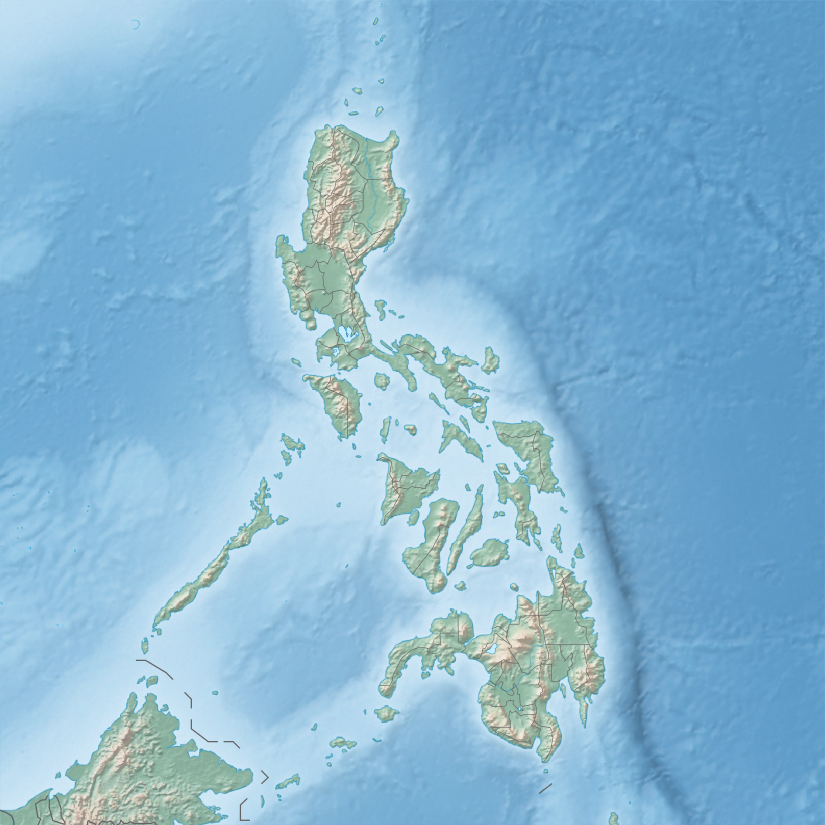
Surigao del Norte, officially the Province of Surigao del Norte, is a province in the Philippines located in the Caraga region of Mindanao. The province was formerly under the jurisdiction of Region 10 until 1995. Its capital is Surigao City. The province comprises two major islands—Siargao and Bucas Grande—in the Philippine Sea, plus a small area at the northeastern tip of mainland Mindanao and other surrounding minor islands and islets. This mainland portion borders Agusan del Norte – between the Municipality of Alegria in Surigao del Norte and the Municipality of Kitcharao in Agusan del Norte; and the province of Surigao del Sur, to the south.

<span class="mw-page-title-main">Surigao del Sur</span> Province in Caraga, Philippines

Surigao del Sur, officially the Province of Surigao del Sur, is a province in the Philippines located in the Caraga region in Mindanao. Its capital is Tandag City. Surigao del Sur is situated at the eastern coast of Mindanao and faces the Philippine Sea to the east.

<span class="mw-page-title-main">Caraga</span> Administrative region of the Philippines

Caraga, officially the Caraga Administrative Region and designated as Region XIII, is an administrative region in the Philippines occupying the northeastern section of Mindanao. The region was created through Republic Act No. 7901 on February 23, 1995. The region comprises five provinces: Agusan del Norte, Agusan del Sur, Dinagat Islands, Surigao del Norte, and Surigao del Sur; six cities: Bayugan, Bislig, Butuan, Cabadbaran, Surigao and Tandag; 67 municipalities and 1,311 barangays. Butuan, the most urbanized city in Caraga, serves as the regional administrative center.

<span class="mw-page-title-main">Dapa, Surigao del Norte</span> Municipality in Surigao del Norte, Philippines

Dapa, officially the Municipality of Dapa, is a 4th class municipality in the province of Surigao del Norte, Philippines. According to the 2020 census, it has a population of 29,006 people.

<span class="mw-page-title-main">Dinagat, Dinagat Islands</span> Municipality in Dinagat Islands, Philippines

Dinagat, officially the Municipality of Dinagat, is a 5th class municipality in the province of Dinagat Islands, Philippines. According to the 2020 census, it has a population of 10,621.

<span class="mw-page-title-main">Surigao City</span> Capital of Surigao del Norte, Philippines

Surigao City, officially the City of Surigao, is a 1st class component city and capital of the province of Surigao del Norte, Caraga Region, on the north-eastern island of Mindanao, Philippines.

<span class="mw-page-title-main">Siargao</span> Philippine island

Siargao is a tear-drop shaped island in the Philippine Sea situated 196 kilometers southeast of Tacloban. It has a land area of approximately 437 square kilometres (169 sq mi). The east coast is relatively straight with one deep inlet, Port Pilar. The coastline is marked by a succession of reefs, small points and white, sandy beaches. The neighboring islands and islets have similar landforms. Siargao is known as the surfing capital of the Philippines, and was voted the Best Island in Asia in the 2021 Conde Nast Travelers Readers awards.

<span class="mw-page-title-main">Dinagat Islands</span> Province in Caraga, Philippines

Dinagat Islands, officially the Province of Dinagat Islands, is an island province in the Caraga region of the Philippines, located on the south side of Leyte Gulf. The island of Leyte is to its west, across Surigao Strait, and mainland Mindanao is to its south. Its main island, Dinagat, is about 60 kilometres (37 mi) from north to south.

<span class="mw-page-title-main">Montenegro Lines</span> Batangas based shipping company

Montenegro Shipping Lines, Inc. (MSLI) is a Philippine domestic shipping line based at Batangas City, Philippines. The office is located at Montenegro Corporate office, along Bolbok Diversion Road, Bolbok Batangas City. It operates passenger, cargo and RORO vessels to various destinations in the Philippines under the brands Montenegro Lines and Marina Ferries.

<span class="mw-page-title-main">Philippine Nautical Highway System</span> Highway system in the Philippines

The Philippine Nautical Highway System, also the Road Roll-on/Roll-off Terminal System (RRTS) or simply the RoRo System, is an integrated network of highway and vehicular ferry routes which forms the backbone of a nationwide vehicle transport system in the Philippines. It is a system of roads and ports developed by the Philippine government to connect the major islands of Luzon, the Visayas and Mindanao. The 919-kilometer (571 mi) nautical highway was opened to the public on April 12, 2003 as the Strong Republic Nautical Highway (SRNH).

The legislative districts of Surigao del Norte are the representations of the province of Surigao del Norte in the various national legislatures of the Philippines. The province is currently represented in the lower house of the Congress of the Philippines through its first and second congressional districts. The 1st legislative district comprises nine municipalities on the islands of Siargao and Bucas Grande ; the 2nd legislative district comprises Surigao City and eleven other municipalities on the mainland of Mindanao.

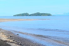
Bucas Grande is an island in the province of Surigao del Norte in the Philippines. The island is contiguous with the municipality of Socorro, Surigao del Norte. Its area is 128 square kilometres (49 sq mi). Its name means "large mouth" or "large opening" in Philippine Spanish in reference to the wide strait in between Bucas Grande and Socorro Island.

<span class="mw-page-title-main">Mines and Geosciences Bureau Region 13 (Philippines)</span>

Mines and Geosciences Bureau - Caraga Region also known as the Caraga Administrative Region, is a government agency responsible for the regulation, management, and development of the mineral resources in the region. It is under the Department of Environment and Natural Resources (DENR). Caraga Region is located at northeastern part of Mindanao. It includes the five provinces of Dinagat Province, Surigao del Norte, Surigao del Sur, Agusan del Norte and Agusan del Sur. Caraga Region is now hosting several mining projects producing various mineral commodities particularly but not limited to gold, copper, chrome, nickel, iron and limestone for concrete cement production. This makes the Department of Environment and Natural Resources, Mines and Geosciences Bureau, Regional Office No. 13 with Office located in Surigao City plays important role in the region's economy, job generation, social and environmental enhancement and protection and ensuring government shares through royalties and taxes.

<span class="mw-page-title-main">Surigao del Norte's 1st congressional district</span>

Surigao del Norte's 1st congressional district is one of the two congressional districts of the Philippines in the province of Surigao del Norte. It has been represented in the House of Representatives since 1987. The district encompasses the island chains off the northeast coast of mainland Surigao del Norte. Since the 2007 redistricting following the separation of Dinagat Islands, the district now comprises the Siargao and Bucas Grande municipalities of Burgos, Dapa, Del Carmen, General Luna, Pilar, San Benito, San Isidro, Santa Monica and Socorro. It is currently represented in the 19th Congress by Francisco Jose Matugas II of the Lakas-CMD.

References

  1. "Administrator Tiangco welcomes 2017". National Mapping and Resource Information Authority (NAMRIA). Retrieved November 15, 2017.
  2. 1 2 Mayuga, Jonathan (February 10, 2016). "Namria 'discovers' 400 previously 'unknown' PHL islands using IfSAR". BusinessMirror. Retrieved February 12, 2016.
  3. Magical Islands Archived July 7, 2013, at the Wayback Machine , Philippine Tourism, retrieved 2012
  4. "Islands by Land Area". Island Directory Tables. United Nations Environment Programme. Archived from the original on February 20, 2018. Retrieved March 4, 2013.
  5. 1 2 "2010 Philippine Yearbook" (PDF). Philippine Yearbook (23rd ed.). Manila, Philippines: National Statistics Office. ISSN   0116-1520 . Retrieved December 14, 2015.
  6. "Province: Romblon". PSGC Interactive. National Statistical Coordination Board. Archived from the original on May 9, 2013. Retrieved March 3, 2013.
  7. Romero, Purple S. (September 20, 2012). "SC affirms creation of Dinagat Island province". RAPPLER. Retrieved May 4, 2024.
  8. "Culion Island". Encyclopædia Britannica. Retrieved April 7, 2011.
  9. 1 2 3 Genevieve Broad; Carl Oliveros. "Biodiversity and conservation priority setting in the Babuyan Islands, Philippines" (PDF). The Technical Journal of Philippine Ecosystems and Natural Resources. 15 (1–2): 1–30. Retrieved April 18, 2018.
  10. "In Sabah: 13 missing seamen feared dead". Manila Standard. September 20, 1996. Retrieved September 24, 2023.
  11. United States Coast Pilot: Palawan, Mindanao, and Sulu archipelago. U.S. Government Printing Office. 1930. p. 33. Retrieved September 24, 2023.
  12. "Philippine Standard Geographic Code (PSGC) – Province: BOHOL". nap.psa.gov.ph. Philippine Statistics Authority. Archived from the original on April 18, 2018. Retrieved April 17, 2018.
  13. "Ten unusual islands for sale". Daily Telegraph. Archived from the original on April 26, 2013.