List of active volcanoes in the Philippines

Last updated

Mayon in Albay is the most active volcano in the Philippines. Mt. Mayon aerial photo.jpg
Mayon in Albay is the most active volcano in the Philippines.

As of 2018, the Philippines has 24 [1] volcanoes listed as active by the Philippine Institute of Volcanology and Seismology (PHIVOLCS). Twenty-one of these have had historical eruptions. The three exceptions are Cabalian, which is a strongly fumarolic volcano;[ further explanation needed ] Leonard Kniaseff, which was active 1,800 years ago (C14), [2] and Isarog, which last erupted around 3500 BCE and 2374 BCE ± 87 based on radiocarbon dating [3] [4] [5]

Contents

Volcanoes in the country have erupted within the last 600 years, with accounts of these eruptions documented by humans; or have erupted within the last 10,000 years (Holocene). There are 100 volcanoes in the Philippines listed by the Smithsonian Institution's Global Volcanism Program (GVP) at present, [6] of which 20 are categorized as "historical" and 59 as "Holocene". [6] The GVP lists volcanoes with historical, Holocene eruptions, or possibly older if strong signs of volcanism are still evident through thermal features like fumaroles, hot springs, mud pots, etc. [7]

List of volcanoes

The list below showing 27 active volcanoes in the Philippines was based on the PHIVOLCS list with some included from the GVP. The number is not definite and depends on someone's definition of "active" or historical time frame. Descriptions under "eruptions" were based on the GVP website. The frequency of historical eruptions excludes questionable or uncertain accounts based on the two sources mentioned.

NameElevation (ASL) [2] Coordinates Province(s) [2] Eruptions [2]
mftDescription and current status
Ambalatungan Group 2,3297,641 17°18′40″N121°06′13″E / 17.310982°N 121.103668°E / 17.310982; 121.103668 (Ambalatungan Group) Kalinga 0Explosions in 1952 is uncertain. [8] Fumarolic with solfataras and thermal springs.
Babuyan Claro 8432,766 19°31′23″N121°56′24″E / 19.523°N 121.940°E / 19.523; 121.940 (Babuyan Claro) Cagayan 3Eruptions were recorded in 1831, 1860 and 1913. Askedna Hot Springs is in the southern base of the volcano.
Banahaw 2,1697,116 14°04′N121°29′E / 14.07°N 121.48°E / 14.07; 121.48 (Banahaw) Laguna, Quezon 4Eruptions were uncertain during the mudflows of 1730, 1743, 1843 and 1909. [9]
Biliran 1,3404,400 11°33′29″N124°30′47″E / 11.558°N 124.513°E / 11.558; 124.513 (Biliran) Biliran 1Phreatic eruption in 1939. Fumarolic with thermal springs
Bulusan 1,5655,135 12°46′12″N124°03′00″E / 12.770°N 124.05°E / 12.770; 124.05 (Bulusan) Sorsogon 17Eruptions years are from 1886 to 2022. Permanently monitored
Cabalian [2] 9453,100 10°17′13.2″N125°13.25′0″E / 10.287000°N 125.22083°E / 10.287000; 125.22083 (Cabalian) Southern Leyte 1Radiocarbon dating on a pyroclastic flow deposit from the volcano estimated that the last eruption was in 1820
Cagua 1,1603,810 18°13′19″N122°07′23″E / 18.222°N 122.123°E / 18.222; 122.123 (Cagua) Cagayan 1Eruption in 1860 and strong solfataric activity in 1907. Thermal areas are near the summit and NW to NNE flanks.
Camiguin de Babuyanes 7122,336 18°49′48″N121°51′36″E / 18.83°N 121.860°E / 18.83; 121.860 (Camiguin de Babuyanes) Cagayan 1Its only recorded eruption was in 1857. Fumarolic with thermal springs
Didicas 8432,766 19°04′37″N122°12′07″E / 19.077°N 122.202°E / 19.077; 122.202 (Didicas) Cagayan 6Eruptions in 1773, 1856, 1900, 1952, 1969 and 1978. A submarine volcano till 1952 when a permanent island was formed. [10]
HibokHibok 1,3324,370 9°12′11″N124°40′23″E / 9.203°N 124.673°E / 9.203; 124.673 (Hibok-Hibok) Camiguin 5Eruption in years 1827, 1862, 1871 and 1948–1952. Activity from 1897–1902 was only solfataric. Permanently monitored.
Iraya 1,0093,310 20°28′08″N122°00′36″E / 20.469°N 122.010°E / 20.469; 122.010 (Iraya) Batanes 1Last eruption was in 1454. Seismic swarm in 1998.
Iriga 1,1433,750 13°27′25″N123°27′25″E / 13.457°N 123.457°E / 13.457; 123.457 (Iriga) Camarines Sur 0The eruption in 1628 was discredited. [11]
Isarog 1,1433,750 13°39′29″N123°22′48″E / 13.658°N 123.38°E / 13.658; 123.38 (Isarog) Camarines Sur 2The last eruption was around 3500 BCE ± 125 years and 2374 BCE ± 87 years based on radiocarbon dating. [12] [13] [14]
Jolo Group 6202,030 6°00′47″N121°03′25″E / 6.013°N 121.057°E / 6.013; 121.057 (Jolo Group) Sulu 0Uncertain submarine eruption in 1897. Listed as Bud Dajo, a cinder cone on Jolo Island, in the PHIVOLCS list.
Kanlaon 2,4357,989 10°24′43″N123°07′55″E / 10.412°N 123.132°E / 10.412; 123.132 (Kanla-on) Negros Occidental, Negros Oriental 26Eruptions were recorded from 1886 to 2006. On November 23, 2015 the volcano had a small, steam-driven explosion. PHIVOLCS raised the alert level to 1 (mild restiveness). Permanently monitored.
Leonard Kniaseff 200660 7°22′55″N126°02′49″E / 7.382°N 126.047°E / 7.382; 126.047 (Leonard Kniaseff) Davao de Oro 0Last eruption was dated as c.120 AD. [15] Strong thermal features.
Makaturing 1,9406,360 7°38′49″N124°19′12″E / 7.647°N 124.32°E / 7.647; 124.32 (Makaturing) Lanao del Sur 2Eruption recorded in 1865 and 1882. The 1856 and 1858 eruptions was credited to Ragang [16] [17]
Matutum 2,2867,500 6°22′N125°04′E / 6.37°N 125.07°E / 6.37; 125.07 (Matutum) South Cotabato 0Mountain was fumarolic on March 7, 1911, but if an eruption occurred was uncertain. Thermal springs in Akmoan and Linan. [18] [19]
Mayon 2,4608,070 13°15′25″N123°41′06″E / 13.257°N 123.685°E / 13.257; 123.685 (Mayon) Albay 54Eruptions were recorded from 1616 to 2023. Permanently monitored. Most recent major volcanic activity occurred in 2023.
Mélébingóy 1,7845,853 6°06′47″N124°53′31″E / 6.113°N 124.892°E / 6.113; 124.892 (Mount Melibengoy) South Cotabato 1A caldera-forming eruption occurred on January 4, 1641.
Musuan 6462,119 7°52′37″N125°04′05″E / 7.877°N 125.068°E / 7.877; 125.068 (Musuan) Bukidnon 2Eruptions in 1866 & 1867. Strong seismic swarm in 1976.
Pinatubo 1,4454,741 15°08′N120°21′E / 15.13°N 120.35°E / 15.13; 120.35 (Pinatubo) Zambales, Tarlac, Pampanga 4Reawakened in 1991, producing the 2nd largest eruption in the 20th century. Followed by milder eruptions in 1992 and 1993. Also minor additional activities in 2021. Permanently monitored.
Ragang 2,8159,236 7°42′N124°30′E / 7.70°N 124.50°E / 7.70; 124.50 (Ragang) Lanao del Sur , Cotabato 7Eruption years are from 1765 to 1873. Eruptions were uncertain in 1915 and 1916.
San Pablo Volcanic Field 1,0903,580 14°07′N121°18′E / 14.12°N 121.30°E / 14.12; 121.30 (San Pablo Volcanic Field) Laguna, Batangas 1Last activity was the formation of Sampaloc Lake around 1350 AD +/- 100 years determined by anthropology [7] [20]
Smith 6882,257 19°32′02″N121°55′01″E / 19.534°N 121.917°E / 19.534; 121.917 (Smith) Cagayan 6Eruption years are from 1652 to 1924. Combined with Babuyan Claro on the GVP list.
Taal 3111,020 14°00′07″N120°59′35″E / 14.002°N 120.993°E / 14.002; 120.993 (Taal) Batangas 39Previous eruption years are from 1572 to 1977. Currently having an ongoing unrest erupting. Permanently monitored.
Unnamed volcano
(Ibugos)
−24−79 20°20′N121°45′E / 20.33°N 121.75°E / 20.33; 121.75 (Unnamed volcano (Ibugos)) Batanes 3Submarine eruptions in 1773, 1850, and 1854.

See also

Related Research Articles

<span class="mw-page-title-main">Mount Iriga</span> Active stratovolcano in the Philippines

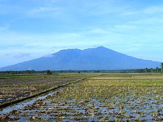
Mount Iriga, also known as Mount Asog, is an active stratovolcano in the province of Camarines Sur, in the Philippines.

Mount Makaturing, also known locally as Palaw a Magatoring, is a stratovolcano on Mindanao island in the Philippines. It is found in the province of Lanao del Sur in the Bangsamoro Autonomous Region in Muslim Mindanao. Makaturing has an elevation of 1,940 metres (6,365 ft) and a base diameter of 29 km (18 mi). It is part of a string of volcanoes called the Central Mindanao Arc.

Mount Ragang, also called Mount Piapayungan and Blue Mountain by the local people, is an active stratovolcano on Mindanao island in the Philippines. With an elevation of 2,815 metres (9,236 ft), it is the seventh highest mountain in the Philippines and the highest point in Lanao del Sur.

<span class="mw-page-title-main">Mount Matutum</span> Volcano on the island of Mindanao, Philippines

Mount Matutum is an active stratovolcano, is the highest point in the province of South Cotabato in the Philippines, with an elevation of 7,500 feet above sea level, approximately 5.7 kilometres (3.5 mi) from Acmonan, Tupi, South Cotabato. Matutum and its foothills are predominantly inhabited by indigenous Blaan families.

<span class="mw-page-title-main">Mount Isarog</span> Active volcano in Camarines Sur, Philippines

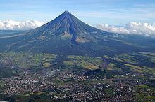
Mount Isarog is an active stratovolcano located in the province of Camarines Sur, Philippines, on the island of Luzon. The mountain has active fumaroles and hot springs. It has an elevation of 2,011.6 m (6,600 ft) above mean sea level.

Mount Leonard Kniaseff, or simply Leonard Kniaseff, is a stratovolcano between the municipalities of Mabini and Maco in the province of Davao de Oro, island of Mindanao, Philippines.

<span class="mw-page-title-main">Mount Binuluan</span> Remote volcano on the island of Luzon in the Philippines

Mount Binuluan is a remote volcano in the Kalinga province of the Cordillera Administrative Region of the Philippines. The 2,329-metre-high (7,641 ft) mountain is part of the Cordillera Central mountain range on Luzon island, the largest island in the country. Binuluan exhibits active volcanism through numerous fumarole fields, solfataras and hot springs on its slope. There were reports of possible eruptions in 1952 and 1986, but they are unverified.

<span class="mw-page-title-main">Cabalian Volcano</span> Active volcano in the Philippines

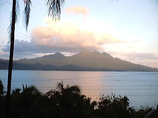
Cabalian Volcano is an active stratovolcano located in the province of Southern Leyte in the Philippines.

<span class="mw-page-title-main">Corregidor Caldera</span> Extinct volcanic caldera

Corregidor Caldera is an extinct volcanic caldera located at the entrance to Manila Bay in the Philippines. The caldera is composed of the islands of Corregidor and Caballo in the province of Cavite, which are believed to be the exposed rim of the volcano.

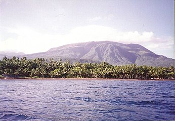
Mount Mandalagan is a complex volcano located at latitude 10.65° North (10°39'0"N), longitude 123.25° East (123°15'0"E), in the province of Negros Occidental, on the north of the island of Negros of the Philippines. It is located inside the Northern Negros Natural Park.

Mount Amorong a potentially active lava dome, part of the Amorong Volcanic Group, is located at the northern end of the Luzon Central Plain, in Umingan, Pangasinan, Region I, on the island of Luzon, in the Philippines.

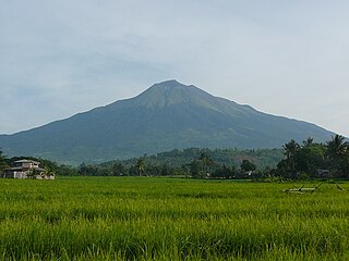
Mount Labo, is a potentially active stratovolcano in the province of Camarines Norte, in the Bicol Region (Region V), on Luzon Island, in the Philippines. It is located at the northwest end of the Bicol Peninsula.

<span class="mw-page-title-main">Mount Natib</span> Dormant startovolcano in Bataan, Philippines

Mount Natib is a dormant stratovolcano and caldera complex in the province of Bataan on western Luzon Island of the Philippines. The volcano complex occupies the northern portion of the Bataan Peninsula. The mountain and adjacent surrounding is a protected area first declared as the Bataan National Park in 1945.

<span class="mw-page-title-main">Mount Masaraga</span> Volcano on the island of Luzon, Philippines

Mount Masaraga is a stratovolcano located in Ligao City in the province of Albay, in the Bicol region, on Luzon Island, in the Philippines.

<span class="mw-page-title-main">Mount Mariveles</span> Stratovolcano in the province of Bataan,Philippines

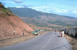
Mount Mariveles is a dormant stratovolcano and the highest point in the province of Bataan in the Philippines. Mariveles and the adjacent Mount Natib comprise 80.9 percent of the total land area of the province. The mountain and adjacent cones lie opposite the city of Manila across Manila Bay, providing a beautiful setting for the sunsets seen from the city.

<span class="mw-page-title-main">Mount Balatukan</span> Compound stratovolcano in Mindanao, Philippines

Mount Balatukan is a massive potentially active compound stratovolcano in the northern island of Mindanao, Philippines. It is the highest point in the province of Misamis Oriental. The volcano has no historical eruptions but displays fumarolic activity. The 2,560-metre (8,400 ft) mountain is topped by a triangular shaped caldera 15 kilometers (9.3 mi) long and 10.6 kilometers (6.6 mi) at its widest. The Balatocan River emanates from and drains the huge crater.

<span class="mw-page-title-main">Malinao Volcano</span> Stratovolcano in the Bicol Region of the Philippines

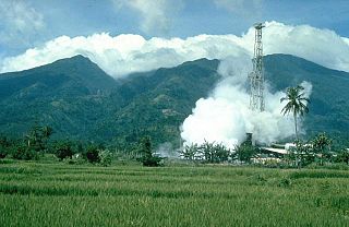
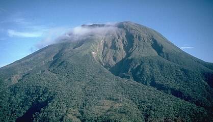
Mount Malinao is a potentially active stratovolcano located in the Bicol Region of the Philippines. The volcano displays strong fumarolic activity which is harnessed for generating electricity. Located on its slope is Tiwi Geothermal Power Plant, one of the first geothermal energy plant commissioned in the country.

References

  1. Philippine Institute of Volcanology and Seismology. "Volcanoes of the Philippines" . Retrieved June 16, 2021.
  2. 1 2 3 4 5 "List of Active Volcanoes". Philippine Institute of Volcanology and Seismology (PHIVOLCS). July 30, 2008. Archived from the original on March 4, 2016.
  3. Smithsonian Institution. "Isarog" . Retrieved June 16, 2021.
  4. Admin, Bicolmail Web (September 16, 2022). "It is official: Mt. Isarog is active". bicolmail. Retrieved October 8, 2022.
  5. Daita, Timothy John E. (January 1, 2020). "Paleomagnetic determination of pyroclastic density current deposits in Tagongtong and Bagumbayan Grande, Goa, Camarines Sur, Philippines and the identification of Isarog volcano's latest eruption age". Virtual GeoCon.
  6. 1 2 "Volcanoes of the Philippines and Southeast Asia". Global Volcanism Program . Smithsonian Institution. Retrieved August 18, 2011.
  7. 1 2 "Volcano Data Criteria". Global Volcanism Program . Smithsonian Institution. Retrieved August 18, 2011.
  8. "Eruption History, Ambalatungan Group". Global Volcanism Program. Retrieved on August 18, 2011.
  9. "Banahaw Eruption History". Global Volcanism Program. Retrieved on August 18, 2011.
  10. "Didicas Eruption History". Global Volcanism Program. Retrieved on August 18, 2011.
  11. "Iriga Eruption History". Global Volcanism Program. Retrieved on August 18, 2011.
  12. Smithsonian Institution. "Isarog" . Retrieved June 16, 2021.
  13. Admin, Bicolmail Web (September 16, 2022). "It is official: Mt. Isarog is active". bicolmail. Retrieved October 8, 2022.
  14. Daita, Timothy John E. (January 1, 2020). "Paleomagnetic determination of pyroclastic density current deposits in Tagongtong and Bagumbayan Grande, Goa, Camarines Sur, Philippines and the identification of Isarog volcano's latest eruption age". Virtual GeoCon.
  15. "Leonard Range Eruption History". Global Volcanism Program. Retrieved on August 18, 2011.
  16. "Makaturing Eruption History". Global Volcanism Program. Retrieved on August 18, 2011.
  17. "Makaturing". Global Volcanism Program. Retrieved on August 18, 2011.
  18. "Matutum". Global Volcanism Program. Retrieved on August 18, 2011.
  19. "Matutum Eruption History". Global Volcanism Program. Retrieved on August 18, 2011.
  20. "San Pablo Volcanic Field Eruption History". Global Volcanism Program. Retrieved on August 18, 2011.