Didicas Volcano is an active volcanic island in the province of Cagayan in northern Philippines. The island, which was a submarine volcano and re-emerged from the sea in 1952, is 22 kilometres (14 mi) NE of Camiguin Island, one of the Babuyan Islands in Luzon Strait. Before 1952, the volcano first breached the ocean surface in 1857.

Babuyan Claro Volcano, also known as Mount Pangasun, is an active volcano located on Babuyan Island, the northernmost of the Babuyan group of islands in Luzon Strait, north of the main island of Luzon in the Philippines. It is classified as one of the active volcanoes of the country with the last confirmed eruption in 1860.
Camiguin de Babuyanes or Mount Camiguin, is an active stratovolcano on Camiguin Island which is part of the Babuyan Islands group that is located in Luzon Strait in the Philippines, north of the island of Luzon located in the municipality of Calayan in the province of Cagayan. The volcano and the island are within the jurisdiction of the municipality of Calayan, in the province of Cagayan. The island has a population of 5,231 people in 2020. There has been only one single eruption by the volcano prior to 1857.

Mount Iraya, is an active stratovolcano on Batan Island and the highest point in the province of Batanes, Philippines.

Smith Volcano, also known as Mount Babuyan, is a cinder cone on Babuyan Island, the northernmost of the Babuyan group of islands on Luzon Strait, north of the main island of Luzon in the Philippines. The mountain is one of the active volcanoes in the Philippines, which last erupted in 1924.

Mount Binuluan is a remote volcano in the Kalinga province of the Cordillera Administrative Region of the Philippines. The 2,329-metre-high (7,641 ft) mountain is part of the Cordillera Central mountain range on Luzon island, the largest island in the country. Binuluan exhibits active volcanism through numerous fumarole fields, solfataras and hot springs on its slope. There were reports of possible eruptions in 1952 and 1986, but they are unverified.
Mount Mandalagan is a complex volcano located at latitude 10.65° North (10°39'0"N), longitude 123.25° East (123°15'0"E), in the province of Negros Occidental, on the north of the island of Negros of the Philippines. It is located inside the Northern Negros Natural Park.

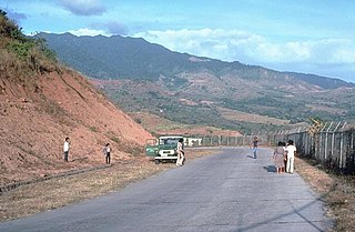
Mount Santo Tomas is a potentially active stratovolcano in the Philippines located in the municipality of Tuba in the province of Benguet. The mountain is part of the protected Santo Tomas Forest Reserve declared through Proclamation No. 581 signed by President Manuel L. Quezon on July 9, 1940.
Patoc is a strongly fumarolic stratovolcano in the Philippines. Patoc is located in Mountain Province, part of the Cordillera Central range, on the island of Luzon, in the Philippines. It is located 6 cadastral kilometres north of Bontoc, at latitude 17.147°N (17°8'48"N), longitude 120.98°E (120°58'48"E).

The Pocdol Mountains, also known as Mount Pocdol, the Pocdol Hills, or the Bacon-Manito Volcanic Group, are a volcanic group of stratovolcanoes in the Philippines, straddling the boundary between the provinces of Albay and Sorsogon.
Mount Labo, is a potentially active stratovolcano in the province of Camarines Norte, in the Bicol Region (Region V), on Luzon Island, in the Philippines. It is located at the northwest end of the Bicol Peninsula.
There is a submarine volcano near the island of Ivuhos in the Philippines.
Mount Panay is a potentially active stratovolcano located in the province of Batangas, Philippines.
Mount Natib is a dormant stratovolcano and caldera complex in the province of Bataan on western Luzon Island of the Philippines. The volcano complex occupies the northern portion of the Bataan Peninsula. The mountain and adjacent surrounding is a protected area first declared as the Bataan National Park in 1945.

Mount Masaraga is a stratovolcano located in Ligao City in the province of Albay, in the Bicol region, on Luzon Island, in the Philippines.
Mount Mariveles is a dormant stratovolcano and the highest point in the province of Bataan in the Philippines. Mariveles and the adjacent Mount Natib comprise 80.9 percent of the total land area of the province. The mountain and adjacent cones lie opposite the city of Manila across Manila Bay, providing a beautiful setting for the sunsets seen from the city.

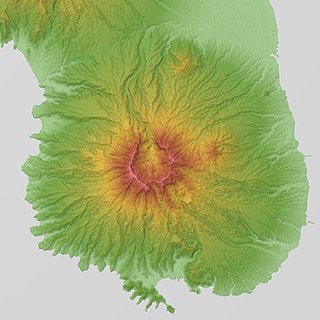
Mount Balatukan is a massive potentially active compound stratovolcano in the Southern island of Mindanao, Philippines. It is the highest point in the province of Misamis Oriental. The volcano has no historical eruptions but displays fumarolic activity. The 2,560-metre (8,400 ft) mountain is topped by a triangular shaped caldera 15 kilometers (9.3 mi) long and 10.6 kilometers (6.6 mi) at its widest. The Balatocan River emanates from and drains the huge crater.
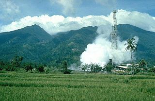
Mount Malinao is a potentially active stratovolcano located in the Bicol Region of the Philippines. The volcano displays strong fumarolic activity which is harnessed for generating electricity. Located on its slope is Tiwi Geothermal Power Plant, one of the first geothermal energy plant commissioned in the country.