List of lakes of the Philippines

Last updated

Several lakes in the Philippines, like Lake Danao in Leyte (pictured), are volcanic in origin. Lake Danao.jpg
Several lakes in the Philippines, like Lake Danao in Leyte (pictured), are volcanic in origin.

The origin of many lakes in the Philippines is closely related to volcanic and tectonic activity. A number of smaller lakes occupy the craters of extinct volcanoes. Some lake basins are developed by subsidence due to tectonic or volcanic activity. Others owe their existence to obstruction of drainage courses by landslides, lava flows and by fragmental volcanic ejecta. [1] [2]

Contents

Among the lakes in the Philippines, three stand out because of their size or economic importance: Laguna de Bay and Taal Lake in Luzon, and Lake Lanao in Mindanao.

List

The following is a partial list of permanent lakes (excluding flood plains ) in the Philippines:

Lake [3] Type [2] AreaSurface
elevation
(m.a.s.l.)
Province Region CoordinatesNotes
Alligator crater lake 23 ha
(57 acres)
2 m
(6 ft 7 in)
Laguna IV-A 14°10′57″N121°12′23″E / 14.18250°N 121.20639°E / 14.18250; 121.20639 (Alligator Lake) Also known as Lake Tadlac, it is located along the shore of Laguna de Bay in Brgy. Tadlac, Los Baños.
Ambuklao reservoir 383 ha
(950 acres)
761 m
(2,497 ft)
Benguet CAR 16°28′25″N120°44′50″E / 16.47361°N 120.74722°E / 16.47361; 120.74722 (Ambuklao Reservoir) Created with the damming of Agno River
Apo crater lake24 ha
(59 acres)
640 m
(2,100 ft)
Bukidnon X 7°52′45″N125°0′21″E / 7.87917°N 125.00583°E / 7.87917; 125.00583 (Lake Apo) Located in west of the city of Valencia
Baao 177 ha
(440 acres)
5 m
(16 ft)
Camarines Sur V 13°27′56″N123°18′53″E / 13.46556°N 123.31472°E / 13.46556; 123.31472 (Lake Baao)
Bababu tectonic lake5 ha
(12 acres)
45 m
(148 ft)
Dinagat Islands XIII 10°4′28″N125°30′33″E / 10.07444°N 125.50917°E / 10.07444; 125.50917 (Lake Bababu)
Balanan landslide lake 25 ha
(62 acres)
237 m
(778 ft)
Negros Oriental XVIII 9°8′16″N122°59′55″E / 9.13778°N 122.99861°E / 9.13778; 122.99861 (Lake Balanan) Created after a landslide from the 1925 earthquake blocked the Balanan River
Balinsasayao crater lake76 ha
(190 acres)
874 m
(2,867 ft) [4]
Negros Oriental XVIII 9°21′11″N123°10′45″E / 9.35306°N 123.17917°E / 9.35306; 123.17917 (Lake Balinsasayao) Twin lake of Lake Danao (Negros)
Basak tectonic lake15 ha
(37 acres)
589 m
(1,932 ft)
Lanao del Sur ARMM 8°2′7″N124°15′32″E / 8.03528°N 124.25889°E / 8.03528; 124.25889 (Basak Lake) Located in Saguiaran, Lanao del Sur
Bato 2,810 ha
(6,900 acres)
10 m
(33 ft)
Camarines Sur V 13°19′57″N123°21′36″E / 13.33250°N 123.36000°E / 13.33250; 123.36000 (Lake Bato)
Bito crater lake140 ha
(350 acres)
2 m
(6 ft 7 in)
Leyte VIII 10°47′19″N124°58′49″E / 10.78861°N 124.98028°E / 10.78861; 124.98028 (Lake Bito)
Buhi landslide1,707 ha
(4,220 acres)
120 m
(390 ft)
Camarines Sur V 13°27′29″N123°30′38″E / 13.45806°N 123.51056°E / 13.45806; 123.51056 (Lake Buhi) Formed after the non-volcanic earthquake of 1628 created a landslide which dammed the Barit River. [5]
Buluan tectonic lake6,134 ha
(15,160 acres)
9 m
(30 ft)
Maguindanao &
Sultan Kudarat
ARMM &
XII
6°38′42″N124°49′38″E / 6.64500°N 124.82722°E / 6.64500; 124.82722 (Lake Buluan)
Bulusan 28 ha
(69 acres)
360 m
(1,180 ft)
Sorsogon V 12°45′16″N124°5′37″E / 12.75444°N 124.09361°E / 12.75444; 124.09361 (Bulusan Lake)
Bunot crater lake31 ha
(77 acres)
153 m
(502 ft)
Laguna IV-A 14°4′53″N121°20′38″E / 14.08139°N 121.34389°E / 14.08139; 121.34389 (Lake Bunot) One of the seven lakes of San Pablo City
Butig tectonic lake25 ha
(62 acres)
762 m
(2,500 ft)
Lanao del Sur ARMM 7°44′2″N124°17′27″E / 7.73389°N 124.29083°E / 7.73389; 124.29083 (Lake Butig)
Cabalian crater lake15 ha
(37 acres)
733 m
(2,405 ft)
Leyte VIII 10°16′47″N125°12′56″E / 10.27972°N 125.21556°E / 10.27972; 125.21556 (Cabalian Lake)
Calibato crater lake42 ha
(100 acres)
184 m
(604 ft)
Laguna IV-A 14°6′12″N121°22′41″E / 14.10333°N 121.37806°E / 14.10333; 121.37806 (Lake Calibato) One of the seven lakes of San Pablo City
Caliraya reservoir1,050 ha
(2,600 acres)
300 m
(980 ft)
Laguna IV-A 14°17′34″N121°31′3″E / 14.29278°N 121.51750°E / 14.29278; 121.51750 (Lake Caliraya) Created with the damming of Caliraya River
Caluangan tectonic lake182 ha
(450 acres)
1 m
(3 ft 3 in)
Oriental Mindoro IV-B 13°22′11″N121°8′11″E / 13.36972°N 121.13639°E / 13.36972; 121.13639 (Lake Caluangan) Also known as Baruyan Lake
Camannauan 3 ha
(7.4 acres)
13 m
(43 ft)
Cagayan II 18°13′29″N121°46′49″E / 18.22472°N 121.78028°E / 18.22472; 121.78028 (Camannauan Lake)
Candelaria 48 ha
(120 acres)
2 m
(6 ft 7 in)
Zambales III 15°36′38″N119°56′34″E / 15.61056°N 119.94278°E / 15.61056; 119.94278 (Lake Candelaria)
Capahayan crater lake [6] 22 ha
(54 acres)
51 m
(167 ft)
Surigao del Norte XIII 9°32′25″N125°34′47″E / 9.54028°N 125.57972°E / 9.54028; 125.57972 (Lake Capayahan) Located in the town of Tubod
Catol tectonic lake19 ha
(47 acres)
7 m
(23 ft)
Zambales III 15°37′17″N119°56′26″E / 15.62139°N 119.94056°E / 15.62139; 119.94056 (Lake Catol) Located in Brgy. Catol, the saltwater lake is one of the four lakes in Candelaria. [7]
Dagianan crater lake3 ha
(7.4 acres)
1,231 m
(4,039 ft)
Lanao del Norte X 7°52′54″N124°1′36″E / 7.88167°N 124.02667°E / 7.88167; 124.02667 (Lake Dagianan)
Dakula tectonic lake12 ha
(30 acres)
10 m
(33 ft)
Sulu ARMM 5°41′55″N120°49′13″E / 5.69861°N 120.82028°E / 5.69861; 120.82028 (Lake Dakula)
Danao crater lake18 ha
(44 acres)
304 m
(997 ft)
Albay V 13°21′33″N123°34′24″E / 13.35917°N 123.57333°E / 13.35917; 123.57333 (Lake Danao (Albay)) Located in Polangui, Albay
Danao tectonic lake680 ha
(1,700 acres)
5 m
(16 ft)
Cebu VII 10°40′25″N124°20′19″E / 10.67361°N 124.33861°E / 10.67361; 124.33861 (Lake Danao (Cebu)) Largest lake in the Visayas
Danao tectonic lake148 ha
(370 acres)
650 m
(2,130 ft)
Leyte VIII 11°4′23″N124°41′33″E / 11.07306°N 124.69250°E / 11.07306; 124.69250 (Lake Danao (Leyte)) Centerpiece of Lake Danao Natural Park
Danao crater lake28 ha
(69 acres)
898 m
(2,946 ft)
Negros Oriental XVIII 9°21′2″N123°11′0″E / 9.35056°N 123.18333°E / 9.35056; 123.18333 (Lake Danao (Negros)) Twin lake of Lake Balinsasayao
Danao crater lake4 ha
(9.9 acres)
450 m
(1,480 ft)
Sorsogon V 13°4′25″N123°58′42″E / 13.07361°N 123.97833°E / 13.07361; 123.97833 (Lake Danao (Sorsogon)) Located in the Pocdol Mountains near Bacon, Sorsogon
Dapao tectonic lake1,012 ha
(2,500 acres)
960 m
(3,150 ft)
Lanao del Sur ARMM 7°47′12″N124°2′36″E / 7.78667°N 124.04333°E / 7.78667; 124.04333 (Lake Dapao)
Dasay 40 ha
(99 acres)
230 m
(750 ft)
Zamboanga del Sur IX 7°39′43″N123°15′11″E / 7.66194°N 123.25306°E / 7.66194; 123.25306 (Lake Dasay)
Duminagat crater lake9 ha
(22 acres)
1,577 m
(5,174 ft)
Misamis Occidental X 8°18′25″N123°36′57″E / 8.30694°N 123.61583°E / 8.30694; 123.61583 (Lake Duminagat) Located inside Mount Malindang Range Natural Park [8]
Ernestine crater lake35 ha
(86 acres)
3 m
(9.8 ft)
Tawi-Tawi ARMM 6°58′25″N118°29′46″E / 6.97361°N 118.49611°E / 6.97361; 118.49611 (Lake Ernestine) One of the three adjacent crater lakes in Mapun, one is open to the sea so is technically not a lake.
Gunao crater lake23 ha
(57 acres)
117 m
(384 ft)
Quezon IV-A 14°0′4″N121°22′17″E / 14.00111°N 121.37139°E / 14.00111; 121.37139 (Lake Gunao)
Himbang tectonic lake26 ha
(64 acres)
14 m
(46 ft)
Agusan del Sur XIII 8°28′4″N125°46′12″E / 8.46778°N 125.77000°E / 8.46778; 125.77000 (Lake Himbang)
Kabalin-an crater lake2 ha
(4.9 acres)
824 m
(2,703 ft)
Negros Oriental XVIII 9°21′55″N123°10′46″E / 9.36528°N 123.17944°E / 9.36528; 123.17944 (Lake Kabalin-an) Located on the same caldera as Lakes Balinsasayao and Danao [9] [10]
Kalanganan tectonic lake12 ha
(30 acres)
512 m
(1,680 ft)
Lanao del Norte X 8°4′59″N124°15′16″E / 8.08306°N 124.25444°E / 8.08306; 124.25444 (Kalanganan Lake) Located in Pantar
La Mesa reservoir463 ha
(1,140 acres)
80 m
(260 ft)
None (located within Quezon City ) NCR 14°43′1″N121°4′46″E / 14.71694°N 121.07944°E / 14.71694; 121.07944 (La Mesa Lake) Part of the Angat-Ipo-La Mesa water system, main source of water for Metro Manila
Laguna de Bay tectonic lake93,000 ha
(230,000 acres)
2 m
(6 ft 7 in)
Cavite,
Laguna,
Rizal &
Quezon
IV-A&NCR 14°20′N121°17′E / 14.333°N 121.283°E / 14.333; 121.283 (Laguna de Bay) Part of the lake is Laguna Caldera
Lanao tectonic lake34,000 ha
(84,000 acres)
700 m
(2,300 ft)
Lanao del Sur ARMM 7°51′N124°15′E / 7.850°N 124.250°E / 7.850; 124.250 (Lake Lanao)
Lanao tectonic lake2 ha
(4.9 acres)
5 m
(16 ft)
Bohol VII 9°52′47″N123°45′51″E / 9.87972°N 123.76417°E / 9.87972; 123.76417 (Lake Lanao (Bohol)) Also spelled "Danao", and also known as Cabilao Island Lake. Located on Cabilao Island [11]
Leonard crater lake70 ha
(170 acres)
800 m
(2,600 ft)
Davao del Norte XI 7°23′37″N126°3′32″E / 7.39361°N 126.05889°E / 7.39361; 126.05889 (Lake Leonard) Partially fills the 4 x 5 km Leonard Caldera
Libuao crater lake24 ha
(59 acres)
800 m
(2,600 ft)
Occidental Mindoro IV-B 7°23′37″N126°3′32″E / 7.39361°N 126.05889°E / 7.39361; 126.05889 (Libuao Lake) Named after the white lotus, Libua in Mangyan, that is abundant on the lake's surface [12] [13]
Looc tectonic lake113 ha
(280 acres)
34 m
(112 ft)
Zambales III 14°54′3″N120°9′56″E / 14.90083°N 120.16556°E / 14.90083; 120.16556 (Looc Lake)
Lumao tectonic lake1,680 ha
(4,200 acres)
17 m
(56 ft)
Agusan del Sur XIII 8°26′39″N125°46′23″E / 8.44417°N 125.77306°E / 8.44417; 125.77306 (Lake Lumao)
Lumot reservoir582 ha
(1,440 acres)
300 m
(980 ft)
Laguna IV-A 14°15′16″N121°32′59″E / 14.25444°N 121.54972°E / 14.25444; 121.54972 (Lumot Lake) Formed by the construction of Lumot Dam, damming Lumot River
Mabilog crater lake2 ha
(4.9 acres)
1,605 m
(5,266 ft)
Negros Oriental VII 9°15′4″N123°10′30″E / 9.25111°N 123.17500°E / 9.25111; 123.17500 (Lake Mabilog) One of the two crater lakes of Cuernos de Negros [14]
Magat reservoir1,122 ha
(2,770 acres)
192 m
(630 ft)
Ifugao &
Isabela
CAR &
II
16°49′30″N121°25′33″E / 16.82500°N 121.42583°E / 16.82500; 121.42583 (Magat Lake) Created with the damming of Magat River
Mahokdum crater lake [6] 22 ha
(54 acres)
190 m
(620 ft)
Surigao del Norte XIII 9°34′7″N125°32′23″E / 9.56861°N 125.53972°E / 9.56861; 125.53972 (Lake Mahokdum)
Mainit tectonic lake17,340 ha
(42,800 acres)
42 m
(138 ft)
Surigao del Norte &
Agusan del Norte
XIII 9°27′31″N125°31′10″E / 9.45861°N 125.51944°E / 9.45861; 125.51944 (Lake Mainit) Second deepest lake in the country at 223 m
(732 ft)
Malimanga tectonic lake12 ha
(30 acres)
7 m
(23 ft)
Zambales III 15°38′41″N119°56′8.5″E / 15.64472°N 119.935694°E / 15.64472; 119.935694 (Lake Malimanga) Located in Brgy. Malimanga, Candelaria, the lake is a protected bird and fish sanctuary since 1980. [15]
Manamlay tectonic lake11 ha
(27 acres)
21 m
(69 ft)
Occidental Mindoro IV-B 12°59′7″N120°51′23″E / 12.98528°N 120.85639°E / 12.98528; 120.85639 (Manamlay Lake) Also known as Panikian Lake for the fruit bats that were abundant in the area. [13] [16]
Manguao tectonic lake741 ha
(1,830 acres)
21 m
(69 ft)
Palawan IV-B 10°45′46″N119°33′1″E / 10.76278°N 119.55028°E / 10.76278; 119.55028 (Lake Manguao)
Mapanuepe lahar-dammed 648 ha
(1,600 acres)
129 m
(423 ft)
Zambales III 14°58′55″N120°17′40″E / 14.98194°N 120.29444°E / 14.98194; 120.29444 (Mapanuepe Lake) Created when lahar from Mount Pinatubo dammed the confluence of Mapanuepe and Marella Rivers.
Maughan crater lake317 ha
(780 acres)
1,338 m
(4,390 ft)
South Cotabato XII 6°6′5″N124°53′20″E / 6.10139°N 124.88889°E / 6.10139; 124.88889 (Lake Maughan) Created with the eruption of Parker Volcano on January 4, 1641
Muhikap crater lake15 ha
(37 acres)
80 m
(260 ft)
Laguna IV-A 14°7′20″N121°20′3″E / 14.12222°N 121.33417°E / 14.12222; 121.33417 (Lake Muhikap) One of the seven lakes of San Pablo City
Nag-aso Boiling thermal lake 3 ha
(7.4 acres)
35 m
(115 ft)
Albay V 13°7′27.8″N123°54′28.10″E / 13.124389°N 123.9078056°E / 13.124389; 123.9078056 (Nag-aso Boiling Lake) Located in Brgy. Holugan, Manito, the hot spring that feed the lake with temperatures of about 100 °C (212 °F) is located in the NE corner of the lake. [17]
Nailig crater lake11 ha
(27 acres)
1,599 m
(5,246 ft)
Negros Oriental XVIII 9°14′52″N123°10′23″E / 9.24778°N 123.17306°E / 9.24778; 123.17306 (Lake Nailig) One of the two crater lakes of Cuernos de Negros [14]
Nalapan tectonic lake3 ha
(7.4 acres)
515 m
(1,690 ft)
Davao del Sur XI 5°46′47″N125°28′49″E / 5.77972°N 125.48028°E / 5.77972; 125.48028 (Nalapan Lake)
Napalit tectonic lake36 ha
(89 acres)
1,041 m
(3,415 ft)
Bukidnon X 7°52′5″N124°47′3″E / 7.86806°N 124.78417°E / 7.86806; 124.78417 (Lake Napalit)
Naujan tectonic lake8,125 ha
(20,080 acres)
20 m
(66 ft)
Oriental Mindoro IV-B 13°10′25″N121°21′12″E / 13.17361°N 121.35333°E / 13.17361; 121.35333 (Naujan Lake)
Nunungan 153 ha
(380 acres)
830 m
(2,720 ft)
Lanao del Norte X 7°49′21″N123°57′19″E / 7.82250°N 123.95528°E / 7.82250; 123.95528 (Lake Nunungan)
Palakpakin crater lake43 ha
(110 acres)
136 m
(446 ft)
Laguna IV-A 14°6′37″N121°20′24″E / 14.11028°N 121.34000°E / 14.11028; 121.34000 (Lake Palakpakin) One of the seven lakes of San Pablo City
Panamao crater lake68 ha
(170 acres)
114 m
(374 ft)
Sulu ARMM 5°58′11″N121°10′13″E / 5.96972°N 121.17028°E / 5.96972; 121.17028 (Lake Panamao) One of the four crater lakes of Jolo island
Pandin crater lake21 ha
(52 acres)
225 m
(738 ft)
Laguna IV-A 14°6′52″N121°22′8″E / 14.11444°N 121.36889°E / 14.11444; 121.36889 (Lake Pandin) One of the seven lakes of San Pablo City
Pantabangan reservoir5,923 ha
(14,640 acres)
202 m
(663 ft)
Nueva Ecija III 15°50′9″N121°9′18″E / 15.83583°N 121.15500°E / 15.83583; 121.15500 (Pantabangan Lake) Largest man-made lake in the Philippines
Paoay tectonic lake403 ha
(1,000 acres)
15 m
(49 ft)
Ilocos Norte I 18°7′12″N120°32′4″E / 18.12000°N 120.53444°E / 18.12000; 120.53444 (Paoay Lake)
Pinag-ulbuan crater lake2 ha
(4.9 acres)
19 m
(62 ft)
Batangas IV-A 14°1′21″N121°0′54″E / 14.02250°N 121.01500°E / 14.02250; 121.01500 (Pinag-ulbuan Lake) Located on eastern side of Taal Volcano Island
Pinamaloy tectonic lake60 ha
(150 acres)
312 m
(1,024 ft)
Bukidnon X 7°40′15″N124°59′59″E / 7.67083°N 124.99972°E / 7.67083; 124.99972 (Lake Pinamaloy) Also known as Lake Pinamalay
Pinatubo crater lake183 ha
(450 acres)
926 m
(3,038 ft)
Zambales [18] III 15°8′37″N120°20′56″E / 15.14361°N 120.34889°E / 15.14361; 120.34889 (Lake Pinatubo) Summit crater lake created after the 1991 eruption of Mount Pinatubo.
Pulangi reservoir1,985 ha
(4,910 acres)
340 m
(1,120 ft)
Bukidnon X 7°48′31″N125°2′19″E / 7.80861°N 125.03861°E / 7.80861; 125.03861 (Pulangi Lake) Powers Pulangi IV Hydroelectric Plant and provides drinking water for Bukidnon
Pulog crater lake2 ha
(4.9 acres)
829 m
(2,720 ft)
Sorsogon V 13°2′33″N123°58′55″E / 13.04250°N 123.98194°E / 13.04250; 123.98194 (Pulog Lake) On the summit of Mt. Pulog in the Pocdol Mountains near Bacon, Sorsogon
Sampaloc crater lake104 ha
(260 acres)
134 m
(440 ft)
Laguna IV-A 14°4′42″N121°19′49″E / 14.07833°N 121.33028°E / 14.07833; 121.33028 (Lake Sampaloc) One of the seven lakes of San Pablo City
San Marcos lahar-dammed24 ha
(59 acres)
222 m
(728 ft)
Tarlac III 15°18′49″N120°23′27″E / 15.31361°N 120.39083°E / 15.31361; 120.39083 (San Marcos Lake) One of the lakes created by lahar from the 1991 eruption of Mount Pinatubo
San Roque reservoir882 ha
(2,180 acres)
155 m
(509 ft)
Pangasinan &
Benguet
I &
CAR
16°9′38″N120°41′28″E / 16.16056°N 120.69111°E / 16.16056; 120.69111 (San Roque Lake) The third reservoir on the Agno River after Ambuklao and Binga Lakes
Sani crater lake11 ha
(27 acres)
130 m
(430 ft)
Sulu ARMM 5°56′4″N121°21′0″E / 5.93444°N 121.35000°E / 5.93444; 121.35000 (Sani Crater Lake) One of the four crater lakes of Jolo island
Sapa tectonic lake112 ha
(280 acres)
23 m
(75 ft)
Tawi-Tawi ARMM 7°0′37″N118°29′28″E / 7.01028°N 118.49111°E / 7.01028; 118.49111 (Lake Sapa)
Sebu 354 ha
(870 acres)
1,000 m
(3,300 ft)
South Cotabato XII 6°13′44″N124°42′18″E / 6.22889°N 124.70500°E / 6.22889; 124.70500 (Lake Sebu)
Seit crater lake59 ha
(150 acres)
17 m
(56 ft)
Sulu ARMM 5°59′17″N121°12′40″E / 5.98806°N 121.21111°E / 5.98806; 121.21111 (Seit Lake) One of the four crater lakes of Jolo island
Singuan crater lake112 ha
(280 acres)
23 m
(75 ft)
Tawi-Tawi ARMM 6°58′19″N118°29′15″E / 6.97194°N 118.48750°E / 6.97194; 118.48750 (Lake Singuan) One of the three adjacent crater lakes in Mapun, one is open to the sea so is technically not a lake.
Sungculan tectonic lake49 ha
(120 acres)
0 m
(0 ft)
Bohol VII 9°38′6″N123°50′11″E / 9.63500°N 123.83639°E / 9.63500; 123.83639 (Sungculan Lake) Sungculan is a saltwater lake located in Brgy. Songculan in Dauis [19]
Taal 23,420 ha
(57,900 acres)
5 m
(16 ft)
Batangas IV-A 13°58′33″N121°0′48″E / 13.97583°N 121.01333°E / 13.97583; 121.01333 (Taal Lake)
Taal Main Crater crater lake121 ha
(300 acres)
5 m
(16 ft)
Batangas IV-A 14°0′41″N120°59′52″E / 14.01139°N 120.99778°E / 14.01139; 120.99778 (Taal Main Crater Lake)
Tambo lahar-dammed79 ha
(200 acres)
286 m
(938 ft)
Tarlac III 15°17′47″N120°22′23″E / 15.29639°N 120.37306°E / 15.29639; 120.37306 (Tambo Lake) One of the lakes created by lahar from the 1991 eruption of Mount Pinatubo
Tikub crater lake47 ha
(120 acres)
53 m
(174 ft)
Quezon IV-A 13°57′46″N121°18′23″E / 13.96278°N 121.30639°E / 13.96278; 121.30639 (Lake Tikub) Also known as Lake Ticob, Ticab or Ticub
Timpuok crater lake32 ha
(79 acres)
3 m
(9.8 ft)
Sulu ARMM 6°2′16″N121°10′45″E / 6.03778°N 121.17917°E / 6.03778; 121.17917 (Lake Timpuok) One of the four crater lakes of Jolo island
Tinagong Dagat crater lake4 ha
(9.9 acres)
915 m
(3,002 ft)
Iloilo VI 11°4′31″N122°19′42″E / 11.07528°N 122.32833°E / 11.07528; 122.32833 (Tinagong Dagat (Lambunao)) Located in Lambunao, Iloilo. Possibly a crater lake.
Uacon tectonic lake70 ha
(170 acres)
0 m
(0 ft)
Zambales III 15°40′19″N119°56′24″E / 15.67194°N 119.94000°E / 15.67194; 119.94000 (Uacon Lake) Uacon Lake is a saltwater lake connected to the sea by a 2-km river. [20]
Uyaan tectonic lake28 ha
(69 acres)
343 m
(1,125 ft)
Lanao del Sur ARMM 7°51′41″N124°3′29″E / 7.86139°N 124.05806°E / 7.86139; 124.05806 (Lake Uyaan) Also known as Lake Ugaan
Venado tectonic lake2,194 m
(7,198 ft)
North Cotabato XII 7°0′11″N125°16′3″E / 7.00306°N 125.26750°E / 7.00306; 125.26750 (Lake Venado) Located on the slope of the tallest mountain in the Philippines, Mount Apo
Wood tectonic lake738 ha
(1,820 acres)
320 m
(1,050 ft)
Zamboanga del Sur IX 7°50′36″N123°9′47″E / 7.84333°N 123.16306°E / 7.84333; 123.16306 (Lake Wood)
Yagumyum crater lake1 ha
(2.5 acres)
1,422 m
(4,665 ft)
Negros Oriental XVIII 9°15′3″N123°11′12″E / 9.25083°N 123.18667°E / 9.25083; 123.18667 (Lake Yagumyum) Straddled between Talinis Peak and Yagumyum Peak of Cuernos de Negros [14]
Yambo crater lake5 ha
(12 acres)
225 m
(738 ft)
Laguna IV-A 14°7′9″N121°21′59″E / 14.11917°N 121.36639°E / 14.11917; 121.36639 (Lake Yambo) One of the seven crater lakes of San Pablo City

Largest and deepest lakes

See also

Related Research Articles

<span class="mw-page-title-main">Geography of the Philippines</span>

The Philippines is an archipelago that comprises 7,641 islands, and with a total land area of 300,000 square kilometers (115,831 sq mi), it is the world's fifth largest island country. The eleven largest islands contain 95% of the total land area. The largest of these islands is Luzon at about 105,000 square kilometers (40,541 sq mi). The next largest island is Mindanao at about 95,000 square kilometers (36,680 sq mi). The archipelago is around 800 kilometers (500 mi) from the Asian mainland and is located between Taiwan and Borneo.

<span class="mw-page-title-main">Luzon</span> Island in the Philippines

Luzon is the largest and most populous island in the Philippines. Located in the northern portion of the Philippine archipelago, it is the economic and political center of the nation, being home to the country's capital city, Manila, as well as Quezon City, the country's most populous city. With a population of 64 million as of 2021, it contains 52.5% of the country's total population and is the 4th most populous island in the world. It is the 15th largest island in the world by land area.

<span class="mw-page-title-main">Calabarzon</span> Administrative region of the Philippines

Calabarzon, sometimes referred to as Southern Tagalog and designated as Region IV‑A, is an administrative region in the Philippines. The region comprises five provinces: Batangas, Cavite, Laguna, Quezon, and Rizal; and one highly urbanized city, Lucena. It is the most populous region in the Philippines according to the Philippine Statistics Authority (PSA), having over 16.1 million inhabitants in 2020, and is also the country's second most densely populated after the National Capital Region. It is situated southeast of Metro Manila, and is bordered by Manila Bay and South China Sea to the west, Lamon Bay and the Bicol Region to the east, Tayabas Bay and the Sibuyan Sea to the south, and Central Luzon to the north. It is home to places like Mount Makiling near Los Baños, Laguna, and Taal Volcano in Batangas.

<span class="mw-page-title-main">Zambales</span> Province in Central Luzon, Philippines

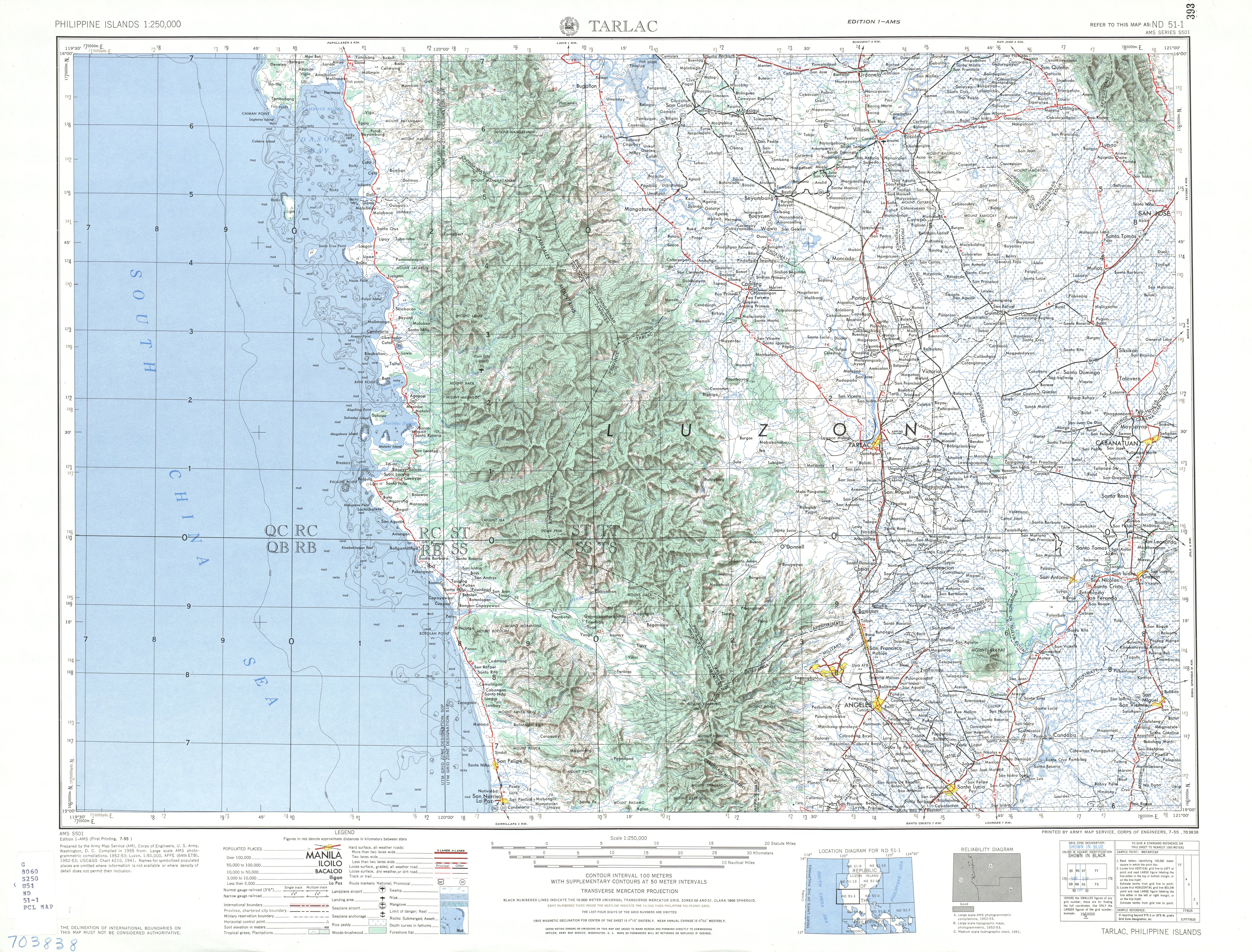
Zambales, officially the Province of Zambales, is a province in the Philippines located in the Central Luzon region. Its capital is Iba, which is located in the middle of the province. Zambales borders Pangasinan to the north and northeast, Tarlac to the east, Pampanga to the southeast, Bataan to the south and the South China Sea to the west. With a total land area of 3,830.83 square kilometres (1,479.09 sq mi), Zambales is the second largest among the seven provinces of Central Luzon after Nueva Ecija. The province is noted for its mangoes, which are abundant from January to April.

<span class="mw-page-title-main">Lanao del Norte</span> Province in Northern Mindanao, Philippines

Lanao del Norte, officially the Province of Lanao del Norte, is a province in the Philippines located in the Northern Mindanao region. Its capital is Tubod.

<span class="mw-page-title-main">Occidental Mindoro</span> Province in Mimaropa, Philippines

Occidental Mindoro, officially the Province of Occidental Mindoro, is a province in the Philippines located in the Mimaropa region. The province occupies the western half of the island of Mindoro. Its capital is Mamburao, but the largest municipality is San Jose occupying almost half of the entire province. As of 2020, Occidental Mindoro has 525,354 inhabitants.

<span class="mw-page-title-main">Negros Oriental</span> Province in Central Visayas, Philippines

Negros Oriental, officially the Province of Negros Oriental, is a province in the Philippines located in the Central Visayas region. Its capital is the city of Dumaguete. It occupies the southeastern half of the large island of Negros, and borders Negros Occidental, which comprises the northwestern half. It also includes Apo Island, a popular dive site for both local and foreign tourists.

<span class="mw-page-title-main">Lanao del Sur</span> Province in Bangsamoro, Philippines

Lanao del Sur, officially the Province of Lanao del Sur, is a province in the Philippines located in the Bangsamoro Autonomous Region in Muslim Mindanao (BARMM). The capital is the city of Marawi, and it borders Lanao del Norte to the north, Bukidnon to the east, and Maguindanao del Norte and Cotabato to the south. To the southwest lies Illana Bay, an arm of the Moro Gulf.

<span class="mw-page-title-main">Mount Pinatubo</span> Active stratovolcano in the Philippines

Mount Pinatubo is an active stratovolcano in the Zambales Mountains, located on the tripoint boundary of the Philippine provinces of Zambales, Tarlac and Pampanga, all in Central Luzon on the northern island of Luzon. Its eruptive history was unknown to most before the pre-eruption volcanic activity of early 1991. Pinatubo was heavily eroded and obscured from view by dense forests which supported a population of several thousand indigenous Aetas.

<span class="mw-page-title-main">Taal Lake</span> Freshwater lake in the province of Batangas, Philippines

Taal Lake, formerly known as Bombón Lake, is a freshwater caldera lake in the province of Batangas, on the island of Luzon in the Philippines. The lake fills Taal Volcano, a large volcanic caldera formed by very large eruptions between 500,000 and 100,000 years ago.

<span class="mw-page-title-main">Mamburao</span> Capital of Occidental Mindoro, Philippines

Mamburao, officially the Municipality of Mamburao, is a 2nd class municipality and capital of the province of Occidental Mindoro, Philippines. According to the 2020 census, it has a population of 47,705 people.

<span class="mw-page-title-main">Sablayan</span> Municipality in Occidental Mindoro, Philippines

Sablayan, officially the Municipality of Sablayan, is a 1st class municipality in the province of Occidental Mindoro, Philippines. According to the 2020 census, it has a population of 92,598 people.

<span class="mw-page-title-main">Outline of the Philippines</span> Overview of and topical guide to the Philippines

The following outline is provided as an overview of and topical guide to the Philippines:

<span class="mw-page-title-main">Polytechnic University of the Philippines Sablayan</span>

Polytechnic University of the Philippines, Sablayan Campus or PUP Sablayan is the 21st PUP campus located in Sitio Macambang, Brgy. Buenavista, municipality of Sablayan, Occidental Mindoro, Philippines. Tt is an LGU-funded campus.

<span class="mw-page-title-main">Davao Occidental</span> Province in Davao Region, Philippines

Davao Occidental, officially the Province of Davao Occidental, is a province in the Philippines located in the Davao Region in Mindanao. Its capital is the municipality of Malita. To the east lies Davao Gulf. It also shares a maritime border with the Indonesian province of North Sulawesi to the south.

<span class="mw-page-title-main">Eduardo Gadiano</span> Filipino politician

Eduardo Baltazar Gadiano is a Filipino politician who has served as Governor of Occidental Mindoro since 2019. He is a member of the Partido Federal ng Pilipinas. He previously served as mayor of Sablayan from 2010 to 2019.

References

  1. Pratt, Wallace E. (1916). "Philippine Lakes" (PDF). Philippine Journal of Science. 11A (5): 223.
  2. 1 2 "Lake Types". U.S. Environmental Protection Agency. Archived from the original on January 13, 2001. Retrieved June 12, 2011.
  3. "Philippines > Lakes". Index Mundi. Archived from the original on May 22, 2011. Retrieved June 12, 2011.
  4. "Philippines > Lakes > Balukbaluk Lake to Lake Baranibud". Index Mundi. Archived from the original on May 22, 2011. Retrieved June 10, 2011.
  5. Paguican, E. M. R.; van Wyk de Vries, B.; Lagmay, A. M. F. (2012). "Volcano-Tectonic Controls and Emplacement Kinematics of the Iriga Debris Avalanches (Philippines)". Bulletin of Volcanology. 74 (9): 2067–2081. doi:10.1007/s00445-012-0652-7.
  6. 1 2 "Paco – Synonym and Subfeatures" Archived October 12, 2012, at the Wayback Machine . Global Volcanism Program. Retrieved on July 1, 2011.
  7. Lhars5 (August 14, 2011). "Fish Trap at Salt Lake Catol (Candelaria, Zambales)". Panoramio. Archived from the original on May 18, 2015. Retrieved May 19, 2012.{{cite web}}: CS1 maint: numeric names: authors list (link)
  8. "Mt. Malindang Range Natural Park". UNESCO World Heritage Tentative List. Archived from the original on October 16, 2011. Retrieved August 28, 2011.
  9. heinzkieh (August 20, 2008). "Lake Kabalin-an". Tampisaw sa Ulan. Archived from the original on March 27, 2012. Retrieved July 18, 2011.
  10. "Tourist Spots". Dumaguete Directory. Archived from the original on April 15, 2011. Retrieved July 18, 2011.
  11. "A Visit to Cabilao Island". Bohol Philippines "God's Little Paradise". March 18, 2006. Archived from the original on August 31, 2011. Retrieved July 13, 2011.
  12. simelguwapo (November 29, 2007). "Sablayan - About the Town". Sablayan, Occidental Mindoro. Archived from the original on March 28, 2012. Retrieved July 28, 2011.
  13. 1 2 "Tourism" Archived March 5, 2016, at the Wayback Machine . Occidental Mindoro Website. Retrieved on July 28, 2011.
  14. 1 2 3 (2009-06-05). "Mt. Talinis/Bediao-Apolong Traverse to Casaroro Falls" Archived September 3, 2011, at the Wayback Machine . Pinoy Mountaineer. Retrieved on July 18, 2011.
  15. "Protected areas in Region 3" Archived March 21, 2012, at the Wayback Machine . Protected Areas and Wildlife Bureau. Retrieved on May 19, 2012.
  16. Collar, Nigel J.; Mallari, Neil Aldrin D.; Tabaranza, Blas R. Jr. (1999). Threatened Birds of the Philippines: The Haribon Foundation/BirdLife International Red Data Book. Makati City: Bookmark. p. 490. ISBN   978-971-569-334-9.
  17. Visit Legazpi (2012–0419). "Nag-aso Boiling Lake, Manito" Archived April 27, 2012, at the Wayback Machine . Wow Legazpi. Retrieved on May 19, 2012.
  18. U.S. Corps of Engineers. "Tarlac map" Archived March 13, 2014, at the Wayback Machine . University of Texas in Austin Library. Retrieved on June 11, 2011.
  19. "Sungculan Lake". Google Maps. Retrieved on May 19, 2012.
  20. Arnell (May 7, 2006). "Uacon, Candelaria, Zambales, Philippines" Archived November 21, 2015, at the Wayback Machine . Virtual Tourist. Retrieved on 2011-07-13.