Fumarole

Last updated

Fumarole at Sol de Manana, Bolivia Sol de Manana 2018.jpg
Fumarole at Sol de Mañana, Bolivia

A fumarole (or fumerole) [1] is a vent in the surface of the Earth or other rocky planet from which hot volcanic gases and vapors are emitted, without any accompanying liquids or solids. Fumaroles are characteristic of the late stages of volcanic activity, but fumarole activity can also precede a volcanic eruption and has been used for eruption prediction. Most fumaroles die down within a few days or weeks of the end of an eruption, but a few are persistent, lasting for decades or longer. An area containing fumaroles is known as a fumarole field.

Contents

The predominant vapor emitted by fumaroles is steam, formed by the circulation of groundwater through heated rock. This is typically accompanied by volcanic gases given off by magma cooling deep below the surface. These volcanic gases include sulfur compounds, such as various sulfur oxides and hydrogen sulfide, and sometimes hydrogen chloride, hydrogen fluoride, and other gases. A fumarole that emits significant sulfur compounds is sometimes called a solfatara.

Fumarole activity can break down rock around the vent, while simultaneously depositing sulfur and other minerals. Valuable hydrothermal mineral deposits can form beneath fumaroles. However, active fumaroles can be a hazard due to their emission of hot, poisonous gases.

Description

Sampling gases at a fumarole on Mount Baker in Washington, United States Baker Fumarole.jpg
Sampling gases at a fumarole on Mount Baker in Washington, United States
Fumaroles at Vulcano, Sicily Fumarola, Vulcano, Sicilia, Italia, 2015.gif
Fumaroles at Vulcano, Sicily

A fumarole (or fumerole; from French fumerolle, a domed structure with lateral openings, built over a kitchen to permit the escape of smoke [2] ) is an opening in a planet's crust which emits steam and gases, but no liquid or solid material. [3] The temperature of the gases leaving the vent ranges from about 100 to 1,000 °C (210 to 1,800 °F). [4] The steam forms when groundwater is superheated by hot rock, then flashes (boils due to depressurization) as it approaches the surface. [5]

In addition to steam, gases released by fumaroles include carbon dioxide, sulfur oxides, hydrogen sulfide, hydrogen chloride, and hydrogen fluoride. These have their origin in magma cooling underground. Not all these gases are present in all fumaroles; for example, fumaroles of Kilauea in Hawaii, US, contain almost no hydrogen chloride or hydrogen fluoride. [3] The gases may also include traces of carbonyl sulfide, carbon disulfide, hydrogen, methane, or carbon monoxide. [6] A fumarole that emits sulfurous gases can be referred to as a solfatara (from old Italian solfo, "sulfur" [7] [8] ). Acid-sulfate hot springs can be formed by fumaroles when some of the steam condenses at the surface. Rising acidic vapors from below, such as CO2 and H2S, will then dissolve, creating steam-heated low-pH hot springs. [9]

Fumaroles are normally associated with the late stages of volcanic activity, [10] although they may also precede volcanic activity [4] and have been used to predict volcanic eruptions. [5] In particular, changes in the composition and temperature of fumarole gases may point to an imminent eruption. [3] An increase in sulfur oxide emissions is a particularly robust indication that new magma is rising from the depths, and may be detectable months to years before the eruption. Continued sulfur oxide emissions after an eruption is an indication that magma is continuing to rise towards the surface. [6]

Fumaroles may occur along tiny cracks, along long fissures, or in chaotic clusters or fields. They also occur on the surface of lava flows and pyroclastic flows. [11] A fumarole field is an area of thermal springs and gas vents where shallow magma or hot igneous rocks release gases or interact with groundwater. [12] When they occur in freezing environments, fumaroles may cause fumarolic ice towers.

Fumaroles may persist for decades or centuries if located above a persistent heat source; or they may disappear within weeks to months if they occur atop a fresh volcanic deposit that quickly cools. [11] The Valley of Ten Thousand Smokes, for example, was formed during the 1912 eruption of Novarupta in Alaska. Initially, thousands of fumaroles occurred in the cooling ash from the eruption, but over time most of them have become extinct. [13] Persistent fumaroles are found at Sulfur Bank on the northern edge of the Kilauea caldera, but most fumaroles in Hawaii last no more than a few months. [3] There are still numerous active fumaroles at Yellowstone National Park, US, [14] some 70,000 years after the most recent eruption. [15]

Economic resources and hazards

Traditional sulfur mining at Kawah Ijen. Bergelut dengan asap nan beracun.jpg
Traditional sulfur mining at Kawah Ijen.

The acidic fumes from fumaroles can break down the rock around the vents, producing brightly colored alteration haloes. [5] At Sulfur Bank near Kilauea, mild alteration reduces the rock to gray to white opal and kaolinite with the original texture of the rock still discernible. Alteration begins along joints in the rock and works inwards until the entire joint block is altered. More extreme alteration (at lower pH) reduces the material to clay minerals and iron oxides to produce red to reddish-brown clay. [16] The same process can produce valuable hydrothermal ore deposits at depth. [5]

Fumaroles emitting sulfurous vapors form surface deposits of sulfur-rich minerals and of fumarole minerals. Sulfur crystals at Sulfur Banks near Kilauea can grow to 2 centimeters (0.8 in) in length, and considerable sulfur has been deposited at Sulfur Cone within Mauna Loa caldera. [3] Places in which these deposits have been mined include:

Sulfur mining in Indonesia is sometimes done for low pay, by hand, without respirators or other protective equipment. [17]

In April 2006 fumarole emissions killed three ski-patrol workers east of Chair 3 at Mammoth Mountain Ski Area in California. The workers were overpowered by an accumulation of toxic fumes (a mazuku ) in a crevasse they had fallen into. [25] [26]

Occurrences

Fumaroles are found around the world in areas of volcanic activity. A few notable examples include:

On Mars

The formation known as Home Plate at Gusev Crater on Mars, which was examined by the Mars Exploration Rover (MER) Spirit, is suspected to be the eroded remains of an ancient and extinct fumarole. [35]

See also

Related Research Articles

A caldera is a large cauldron-like hollow that forms shortly after the emptying of a magma chamber in a volcano eruption. When large volumes of magma are erupted over a short time, structural support for the rock above the magma chamber is gone. The ground surface then collapses into the emptied or partially emptied magma chamber, leaving a large depression at the surface. Although sometimes described as a crater, the feature is actually a type of sinkhole, as it is formed through subsidence and collapse rather than an explosion or impact. Compared to the thousands of volcanic eruptions that occur each century, the formation of a caldera is a rare event, occurring only a few times per century. Only seven caldera-forming collapses are known to have occurred between 1911 and 2016. More recently, a caldera collapse occurred at Kīlauea, Hawaii in 2018.

<span class="mw-page-title-main">Volcano</span> Rupture in the crust of a planet that allows lava, ash, and gases to escape from below the surface

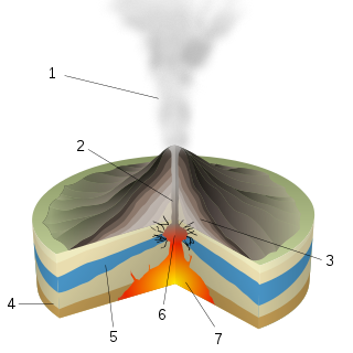
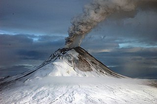
A volcano is a rupture in the crust of a planetary-mass object, such as Earth, that allows hot lava, volcanic ash, and gases to escape from a magma chamber below the surface.

<span class="mw-page-title-main">Long Valley Caldera</span> Geologic depression near Mammoth Mountain, California, United States

Long Valley Caldera is a depression in eastern California that is adjacent to Mammoth Mountain. The valley is one of the Earth's largest calderas, measuring about 20 mi (32 km) long (east-west), 11 mi (18 km) wide (north-south), and up to 3,000 ft (910 m) deep.

<span class="mw-page-title-main">Geothermal areas of Yellowstone</span> Geyser basins and other geothermal features in Yellowstone National Park

The geothermal areas of Yellowstone include several geyser basins in Yellowstone National Park as well as other geothermal features such as hot springs, mud pots, and fumaroles. The number of thermal features in Yellowstone is estimated at 10,000. A study that was completed in 2011 found that a total of 1,283 geysers have erupted in Yellowstone, 465 of which are active during an average year. These are distributed among nine geyser basins, with a few geysers found in smaller thermal areas throughout the Park. The number of geysers in each geyser basin are as follows: Upper Geyser Basin (410), Midway Geyser Basin (59), Lower Geyser Basin (283), Norris Geyser Basin (193), West Thumb Geyser Basin (84), Gibbon Geyser Basin (24), Lone Star Geyser Basin (21), Shoshone Geyser Basin (107), Heart Lake Geyser Basin (69), other areas (33). Although famous large geysers like Old Faithful are part of the total, most of Yellowstone's geysers are small, erupting to only a foot or two. The hydrothermal system that supplies the geysers with hot water sits within an ancient active caldera. Many of the thermal features in Yellowstone build up sinter, geyserite, or travertine deposits around and within them.

<span class="mw-page-title-main">Geothermal areas in Lassen Volcanic National Park</span>

The geothermal areas in Lassen Volcanic National Park include several groups of hot springs and fumaroles, as remnants of former volcanic activity, exist in Lassen Volcanic National Park in northeastern California. Most of these lie in or are closely adjacent to Mount Tehama's caldera. Bumpass Hell is the most spectacular of these, but others of importance are Sulphur Works, Little Hot Springs Valley, Boiling Springs Lake and Devil's Kitchen. In each thermal area, the highest temperature of water generally is close to the boiling temperature at the altitude of the particular spring or fumarole — 198 °F (92 °C) at Bumpass Hell and 191 °F (88 °C) on the northwest flanks of Lassen Peak. Temperatures as high as 230 °F (110 °C) have been recorded in the park.

<span class="mw-page-title-main">Yellowstone Caldera</span> Volcanic caldera in Yellowstone National Park in the United states

The Yellowstone Caldera, sometimes referred to as the Yellowstone Supervolcano, is a volcanic caldera and supervolcano in Yellowstone National Park in the Western United States. The caldera and most of the park are located in the northwest corner of Wyoming. The caldera measures 43 by 28 miles, and postcaldera lavas spill out a significant distance beyond the caldera proper.

<span class="mw-page-title-main">Phreatic eruption</span> Volcanic eruption caused by an explosion of steam

A phreatic eruption, also called a phreatic explosion, ultravulcanian eruption or steam-blast eruption, occurs when magma heats ground water or surface water. The extreme temperature of the magma causes near-instantaneous evaporation of water to steam, resulting in an explosion of steam, water, ash, rock, and volcanic bombs. At Mount St. Helens in Washington state, hundreds of steam explosions preceded the 1980 Plinian eruption of the volcano. A less intense geothermal event may result in a mud volcano.

<span class="mw-page-title-main">Mud volcano</span> Landform created by the eruption of mud or slurries, water and gases

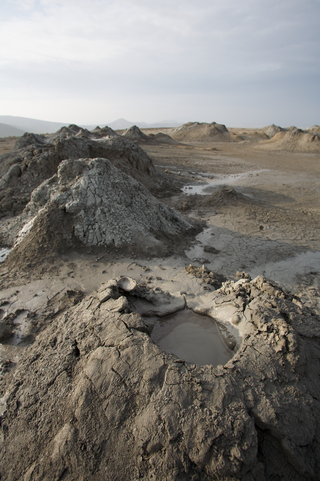
A mud volcano or mud dome is a landform created by the eruption of mud or slurries, water and gases. Several geological processes may cause the formation of mud volcanoes. Mud volcanoes are not true igneous volcanoes as they do not produce lava and are not necessarily driven by magmatic activity. Mud volcanoes may range in size from merely 1 or 2 meters high and 1 or 2 meters wide, to 700 meters high and 10 kilometers wide. Smaller mud exudations are sometimes referred to as mud-pots.

<span class="mw-page-title-main">Volcanic gas</span> Gases given off by active volcanoes

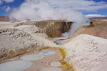
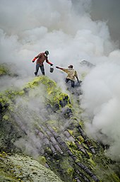
Volcanic gases are gases given off by active volcanoes. These include gases trapped in cavities (vesicles) in volcanic rocks, dissolved or dissociated gases in magma and lava, or gases emanating from lava, from volcanic craters or vents. Volcanic gases can also be emitted through groundwater heated by volcanic action.

<span class="mw-page-title-main">Taftan (volcano)</span> Volcano mountain in Iran

Taftan is an active stratovolcano in south-eastern Iran in the Sistan and Baluchestan province. With variable heights reported, all around 4,000 metres (13,000 ft) above sea level, it is the highest mountain in south-eastern Iran. The nearest city is Khash.

<span class="mw-page-title-main">Tacora</span> Stratovolcano in Parinacota Province, Chile

Tacora is a stratovolcano located in the Andes of the Arica y Parinacota Region of Chile. Near the border with Peru, it is one of the northernmost volcanoes of Chile. It is part of the Central Volcanic Zone in Chile, one of the four volcanic belts of the Andes. The Central Volcanic Zone has several of the highest volcanoes in the world. Tacora itself is a stratovolcano with a caldera and a crater. The youngest radiometric age is 50,000 years ago and it is heavily eroded by glacial activity.

<span class="mw-page-title-main">Volcán Putana</span> Mountain in Chile

Volcán Putana, sometimes referred to as Jorqencal or Machuca, is a stratovolcano located In the Central Volcanic Zone (CVZ) of the Andes on the border between Bolivia and Chile and close to the Sairecabur volcanic complex. Its summit is 5,884 metres (19,304 ft) above sea level and contains a summit crater with two smaller craters nested within it. Beneath the summit, the volcano features a number of lava domes and lava flows, some of which originated in flank vents.

<span class="mw-page-title-main">Halemaʻumaʻu</span> Pit crater located within the summit caldera of Kīlauea in Hawaii

Halemaʻumaʻu is a pit crater within the much larger Kīlauea Caldera at the summit of Kīlauea volcano on island of Hawaiʻi. The roughly circular crater was 770 meters (2,530 ft) x 900 m (2,950 ft) before collapses that roughly doubled the size of the crater after May 3, 2018. Following the collapses of 2018, the bottom of Halemaʻumaʻu was roughly 600 m (2,000 ft) below the caldera floor. Halemaʻumaʻu is home to Pele, goddess of fire and volcanoes, according to the traditions of Hawaiian religion. Halemaʻumaʻu means "house of the ʻāmaʻu fern".

<span class="mw-page-title-main">Lava</span> Molten rock expelled by a volcano during an eruption

Lava is molten or partially molten rock (magma) that has been expelled from the interior of a terrestrial planet or a moon onto its surface. Lava may be erupted at a volcano or through a fracture in the crust, on land or underwater, usually at temperatures from 800 to 1,200 °C. The volcanic rock resulting from subsequent cooling is also often called lava.

<span class="mw-page-title-main">Lastarria</span> Stratovolcano on the border between Chile and Argentina

Lastarria is a 5,697 metres (18,691 ft) high stratovolcano that lies on the border between Chile and Argentina. It is remote, and the surroundings are uninhabited but can be reached through an unpaved road. The volcano is part of the Central Volcanic Zone, one of the four segments of the volcanic arc of the Andes. Over a thousand volcanoes—of which about 50 are active—lie in this over 1,500 kilometres (930 mi) long chain of volcanoes, which is generated by subduction of the Nazca Plate beneath the South American Plate.

<span class="mw-page-title-main">Ubinas</span> Volcano in southern Peru

Ubinas is an active stratovolcano in the Moquegua Region of southern Peru, approximately 60 kilometres (37 mi) east of the city of Arequipa. Part of the Central Volcanic Zone of the Andes, it rises 5,672 metres (18,609 ft) above sea level. The volcano's summit is cut by a 1.4-kilometre-wide (0.87 mi) and 150-metre-deep (490 ft) caldera, which itself contains a smaller crater. Below the summit, Ubinas has the shape of an upwards-steepening cone with a prominent notch on the southern side. The gently sloping lower part of the volcano is also known as Ubinas I and the steeper upper part as Ubinas II; they represent different stages in the volcano's geological history.

<span class="mw-page-title-main">Dallol (hydrothermal system)</span> Terrestrial hydrothermal system of Danakil Depression in northeastern Ethiopia

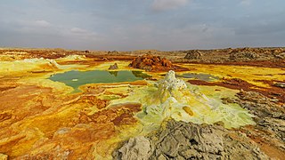
Dallol is a unique, terrestrial hydrothermal system around a cinder cone volcano in the Danakil Depression, northeast of the Erta Ale Range in Ethiopia. It is known for its unearthly colors and mineral patterns, and the very acidic fluids that discharge from its hydrothermal springs.

<span class="mw-page-title-main">Seltún Hot Springs</span> Geothermal hot spring area in Iceland

Seltún Hot Springs, Icelandic pronunciation:[ˈsɛlˌtʰuːn], is a geothermal hot spring system in Krýsuvík volcanic area, in southwest Iceland on the Mid-Atlantic Ridge of the Reykjanes peninsula.

<span class="mw-page-title-main">Guallatiri</span> Mountain in Parinacota Province Chile

Guallatiri is a 6,071-metre (19,918 ft) high volcano in Chile. It is located southwest of the Nevados de Quimsachata volcanic group and is sometimes considered to be part of that group. It is a stratovolcano with numerous fumaroles around the summit. The summit may be composed of either a lava dome or a pyroclastic cone, while the lower flanks of the volcano are covered by lava flows and lava domes. The volcano's eruptions have produced mostly dacite along with andesite and rhyolite.

<span class="mw-page-title-main">Geothermal activity</span> Activity resulting from underground heat

Geothermal activity is a group of natural heat transfer processes, occurring on Earth's surface, caused by the presence of excess heat in the subsurface of the affected area. Geothermal activity can manifest itself in a variety of different phenomena, including, among others, elevated surface temperatures, various forms of hydrothermal activity, and the presence of fumaroles that emit hot volcanic gases.

References

  1. "fumerole – Definition and meaning". Merriam-Webster.com Dictionary. Merriam-Webster . Retrieved 4 June 2023.
  2. "fumarole" . Oxford English Dictionary (Online ed.). Oxford University Press.(Subscription or participating institution membership required.)
  3. 1 2 3 4 5 Macdonald, Gordon A.; Abbott, Agatin T.; Peterson, Frank L. (1983). Volcanoes in the sea : the geology of Hawaii (2nd ed.). Honolulu: University of Hawaii Press. pp. 53–55. ISBN   0824808320.
  4. 1 2 Allaby, Michael (2013). A dictionary of geology and earth sciences (Fourth ed.). Oxford: Oxford University Press. ISBN   9780199653065.
  5. 1 2 3 4 Philpotts, Anthony R.; Ague, Jay J. (2009). Principles of igneous and metamorphic petrology (2nd ed.). Cambridge, UK: Cambridge University Press. p. 70. ISBN   9780521880060.
  6. 1 2 Schmincke, Hans-Ulrich (2004). Volcanism. Springer Science & Business Media. p. 47. ISBN   9783540436508.
  7. "solfatara" . Oxford English Dictionary (Online ed.). Oxford University Press.(Subscription or participating institution membership required.)
  8. "Solfatara". Merriam-Webster.com Dictionary. Merriam-Webster. Retrieved 20 February 2020.
  9. White, D.E.; Muffler, L.J.P.; Truesdell, A.H. (1971). "Vapor-dominated hydrothermal systems compared with hot-water systems". Economic Geology. 66 (1): 75–97. Bibcode:1971EcGeo..66...75W. doi:10.2113/gsecongeo.66.1.75.
  10. Jackson, Julia A., ed. (1997). "fumarole". Glossary of geology (Fourth ed.). Alexandria, Virginia: American Geological Institute. ISBN   0922152349.
  11. 1 2 PD-icon.svg This article incorporates public domain material from "Fumarole". USGS Photo Glossary. United States Geological Survey . Retrieved 6 February 2019.
  12. Neuendorf, Klaus K. E. (2005). Jackson, Julia A.; Mehl, James P.; Neuendorf, Klaus K. E. (eds.). Glossary of Geology. Springer Science & Business Media. p. 257. ISBN   9780922152766 . Retrieved 6 June 2015. fumarole field[:] A group of cool fumaroles.
  13. Hildreth, W.; Fierstein, J. (2012). The Novarupta-Katmai eruption of 1912– largest eruption of the twentieth century; centennial perspectives. Reston: USGS Professional Paper 1791. p. 135.
  14. "Fumaroles". Volcanic Features and Landforms. National Park Service. Retrieved 1 March 2022.
  15. "Summary of Eruption History". Yellowstone Geology and History. U.S. Geological Survey. Retrieved 1 March 2022.
  16. Macdonald, Abbott & Peterson 1983, p. 134.
  17. 1 2 "Kawah Ijen: Between potential & threat". The Jakarta Post. 19 December 2011.
  18. Dukehart, Coburn (17 November 2015). "The Struggle and Strain of Mining "Devil's Gold"". National Geographic. Retrieved 1 March 2022.
  19. Pfeiffer, Tom (2006). "Welirang volcano photos". Volcano Discovery. Retrieved 1 March 2022.
  20. Global Volcanism Program, National Museum of Natural History, Smithsonian Institution
  21. Simpson, Mark P.; Bignall, Greg (January 2016). "Undeveloped high-enthalpy geothermal fields of the Taupo Volcanic Zone, New Zealand". Geothermics. 59: 325–346. Bibcode:2016Geoth..59..325S. doi:10.1016/j.geothermics.2015.08.006.
  22. "Eruption on Whakaari White Island kills 10 people". nzhistory.govt.nz. Retrieved 26 October 2021.
  23. "Disaster at White Island". New Zealand Geographic. Retrieved 26 October 2021.
  24. Ferrara, Vincenzo (2016). "The Sulphur Mining Industry in Sicily". Essays on the History of Mechanical Engineering. History of Mechanism and Machine Science. Vol. 31. pp. 111–130. doi:10.1007/978-3-319-22680-4_8. ISBN   978-3-319-22679-8.
  25. Hymon, Steve; Covarrubias, Amanda (9 April 2006). "How Routine Turned to Tragedy at Mammoth". Los Angeles Times. Retrieved 9 May 2011.
  26. Cantrell, Lee; Young, Michael (March 2009). "Fatal Fall into a Volcanic Fumarole". Wilderness & Environmental Medicine. 20 (1): 77–79. doi: 10.1580/08-WEME-CR-199.1 . PMID   19364170. S2CID   207182190.
  27. Carrabba, Paola (2010). "The Gate of Hades: The Phlegraean Fields". Natural Heritage from East to West. pp. 193–200. doi:10.1007/978-3-642-01577-9_24. ISBN   978-3-642-01576-2.
  28. Troiano, A.; Isaia, R.; Tramparulo, F. D. A.; Di Giuseppe, M. G. (December 2021). "The Pisciarelli main fumarole mechanisms reconstructed by electrical resistivity and induced polarization imaging". Scientific Reports. 11 (1): 18639. Bibcode:2021NatSR..1118639T. doi:10.1038/s41598-021-97413-1. PMC   8452721 . PMID   34545113.
  29. Tamburello, G.; Hansteen, T. H.; Bredemeyer, S.; Aiuppa, A.; Tassi, F. (28 July 2014). "Gas emissions from five volcanoes in northern Chile and implications for the volatiles budget of the Central Volcanic Zone: Volatiles budget of the CVZ, Chile". Geophysical Research Letters. 41 (14): 4961–4969. doi:10.1002/2014GL060653. hdl: 10447/99158 . S2CID   55877335.
  30. Paola, G. M. (June 1971). "Geology of the Corbetti Caldera area (Main Ethiopian Rift Valley)". Bulletin Volcanologique. 35 (2): 497–506. Bibcode:1971BVol...35..497D. doi:10.1007/BF02596970. S2CID   130428510.
  31. "Fumaroles". Manaaki Whenua Landcare Research. Retrieved 1 March 2022.
  32. Symonds, R.B.; Mizutani, Y.; Briggs, Paul H. (1996). "Long-term geochemical surveillance of fumaroles at Showa-Shinzan dome, Usu volcano, Japan". Journal of Volcanology and Geothermal Research. 73 (3–4): 177–211. Bibcode:1996JVGR...73..177S. doi:10.1016/0377-0273(96)00029-7.
  33. "Morne Trois Pitons National Park". UNESCO . 1997. Retrieved 28 July 2020.
  34. "Hydrothermal Features". Yellowstone National Park. U.S. National Park Service. Retrieved 1 March 2022.
  35. R.V.Morris, S.W.Squyres, et al. "The Hydrothermal System at Home Plate in Gusev Crater, Mars". Lunar & Planetary Science XXXIX(2008)