Morne Trois Pitons National Park

Last updated

Morne Trois Pitons National Park
Dominica Hiking Path.JPG
Hiking trail in the Morne Trois Pitons National Park
Location Dominica
Coordinates 15°19′30″N61°19′00″W / 15.32500°N 61.31667°W / 15.32500; -61.31667
Area68.57 km²
Established1975
TypeNatural
Criteriaviii, x
Designated1997 (21st session)
Reference no. 814
Region Latin America and the Caribbean

Morne Trois Pitons National Park is a national park in Dominica established in July 1975, the first to be legally established in the country. It became a World Heritage Site in 1997. [1] The park is named after its highest mountain, Morne Trois Pitons, meaning mountain of three peaks. The park is an area of significant volcanic activity. Features within the park include the Valley of Desolation, a region of boiling mud ponds and small geysers; the Boiling Lake; Titou Gorge; and Emerald Pool. The mountain is the second-highest peak in Dominica, being exceeded only by Morne Diablotins (1,447 m (4,747 ft)). [2]

Contents

Background

The park was established in 1975 and was designated a UNESCO World Heritage Site in 1997. Its area is about 7,000 hectares (17,000 acres), and it is dominated by the Morne Trois Pitons volcanoes (1,342 m (4,403 ft)), from which it gets its name. The three major types of geological formations found in the park are volcanic cones, glacis slopes, and soufrières (sulphur deposits). The landscape consists of steep-sided volcanic hills separated by deep canyons. All the major waterways of the southern half of the island emanate from here, and there are spectacular waterfalls, creeks, rivers, pools, and natural lakes. Ongoing volcanic activity is demonstrated by the fumaroles and hot springs, geysers, mud pools, and streams of various colours. [3] The Boiling Lake is a water-filled fumarole with a temperature of 180 to 197 °F (82–92 °C) near the edge and a hotter centre, where boiling water churns up from the depths. [4]

The park is managed by the Division of Forestry, Wildlife and National Parks, under the auspices of the Ministry of Agriculture and Fisheries. The steep and rugged terrain has discouraged development, and there are no human settlements within the park. However, there is a small quarry and some limited farming in the southern portion; the government's electric utility company has certain rights, but these are being used for hydropower and the extraction of geothermal energy. There is some risk to wildlife from the incursion of feral cats, pigs, and rats, and there is a risk from invasive alien species. The island is occasionally devastated by hurricanes, with serious damage being done to the park by Hurricane David (1979) and Hurricane Allen (1980). A proposal to encourage tourism by the construction of a cable car overhead was defeated, but a fine balance needs to be struck between human aspirations and the maintenance of biodiversity and the unique landscape. [3]

Flora

Most of the area of the park retains its natural habitat and there are a number of different vegetation zones, tropical rainforest, secondary forest, deciduous forest, montane rainforest, and dwarf forest. The large trees in the rainforest tower up to 30 and 40 m (100 and 130 ft) and have large buttress roots. The dominant tree is Amanoa caribaea , but Sloanea dengata , Sloanea caribaea , and Sloanea berteroana are also plentiful; Symphonia globulifera and Cecropia peltata have both massive buttresses and prop roots. The trees are interspersed with tree ferns and are swathed in epiphytes including orchids and bromeliads. At higher altitudes, the trees become smaller, and there are mountain palms, ferns, and hibiscus, while near the summits there is dwarf forest with low, branching shrubs, mosses, and lichens. In the Valley of Desolation, the sulphurous gases limits the vegetation, and there are Clusia mangle , grasses, and bromeliads. [5]

Fauna

Mammals found in the park include agoutis, wild pigs, common opossums, numerous small rodents, and bats. There are large numbers of birds in the forest, but they are often heard rather than seen. There are four species of hummingbird, the rufous-throated solitaire, and two endemic parrots, the imperial amazon, and the red-necked amazon. The endemic Dominican anole Anolis oculatus can be found here as well as numerous species of tree frog. [5]

See also

Related Research Articles

<span class="mw-page-title-main">Geography of Dominica</span> Geography of the island country of Dominica

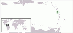
Dominica is an island in the Caribbean Sea, located about halfway between the French islands of Guadeloupe and Martinique. Its coordinates are 15 25 N, 61 20 W. It is known as "The Nature Island of the Caribbean" due to its spectacular, lush, and varied flora and fauna, which is protected by an extensive natural park system. It is the fourth largest island in the Eastern Caribbean with a population of people mainly of African descent.

<span class="mw-page-title-main">Fumarole</span> Volcanic opening that emits hot gases

A fumarole is a vent in the surface of the Earth or other rocky planets from which hot volcanic gases and vapors are emitted, without any accompanying liquids or solids. Fumaroles are characteristic of the late stages of volcanic activity, but fumarole activity can also precede a volcanic eruption and has been used for eruption prediction. Most fumaroles die down within a few days or weeks of the end of an eruption, but a few are persistent, lasting for decades or longer. An area containing fumaroles is known as a fumarole field.

<span class="mw-page-title-main">Boiling Lake</span> Lake in Morne Trois Pitons National Park, Dominica

The Boiling Lake is a flooded fumarole located in Morne Trois Pitons National Park, a World Heritage Site on the island of Dominica. The lake, located 6.5 miles (10.5 km) east of Dominica's capital Roseau, is filled with bubbling greyish-blue water that is usually enveloped in a cloud of vapour. The Boiling Lake is approximately 200 to 250 feet across and is the second-largest hot lake in the world after Frying Pan Lake, located in Waimangu Valley near Rotorua, New Zealand.

<span class="mw-page-title-main">Pitons (Saint Lucia)</span> Mountainous volcanic plug in Saint Lucia

The Pitons are two mountainous volcanic plugs, volcanic spires, located in Saint Lucia. Petit Piton is 743 m (2,438 ft) high and Gros Piton is 798.25 m (2,618.9 ft) high; they are linked by the Piton Mitan ridge. The Pitons are a World Heritage Site, 2,909 ha in size, and located near the town of Soufrière.

<span class="mw-page-title-main">Carbet Mountains</span>

The Carbet Mountains are a massif of volcanic origin on the Caribbean island of Martinique.

<span class="mw-page-title-main">Emerald Pool</span>

Emerald Pool is the name of several locations.

<span class="mw-page-title-main">Imperial amazon</span> Species of rare bird in the Caribbean

The imperial amazon or Dominican amazon, also known as the sisserou or sisserou parrot, is a parrot found only on the Caribbean island of Dominica. It has been designated as the national bird of Dominica. The species is critically endangered. In 2019, it was estimated there were only about 50 mature individuals left in the wild.

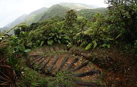
Morne Watt or Watt Mountain is a mountain consisting of one or more stratovolcanoes at the south end of Dominica in the eastern Caribbean Sea. With an elevation of 1,224 m (4,016 ft), it is the third highest mountain in Dominica after Morne Diablotins and Morne Trois Pitons. The mountain is home to the Boiling Lake and Valley of Desolation thermal areas, both of which are the best-known volcanic features in Dominica and major tourist attractions in Morne Trois Pitons National Park.

<span class="mw-page-title-main">Laudat</span> Village in Saint George, Dominica

Laudat is a small village in the interior of Dominica, located between 3 mountains: Morne Watt, Morne Micotrine, and Morne Trois Pitons. With a population of just above 300 people, Laudat is referred to as a "gateway" because it is the sole entry point to many of the islands sights, including the Boiling Lake, Fresh Water Lake, and Titou Gorge. Perched about 1200 feet above sea level Laudat has a cool climate and views of the Caribbean Sea. It is located approximately 20 minutes from the capital, Roseau and is at the end of the road. The road to Laudat used to be a hair-raising ride up the mountains, around blind hairpin turns with sharp drop-offs into the jungle canopy; however, the road has been improved and may be completed by the time of this writing. Laudat has seen many changes over the past years, including the aerial tram taking visitors from the village up into the high mountains--making possible what was previously a journey by foot. Titou Gorge was also altered over the last decade, and is now smaller and more developed. It is still a swimming place, and small waterfalls of hot and cold water stream into the gorge. There are some overnight accommodations available in the village. Laudat receives some of the highest rainfalls in the Caribbean, about 900 cm a year. The air is often misty and cool - a change from the heat of lower-lying areas.

<span class="mw-page-title-main">Dominica</span> Island country in the Caribbean

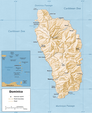
Dominica officially the Commonwealth of Dominica, is an island country in the Caribbean. The capital, Roseau, is located on the western side of the island. It is geographically situated as part of the Windward Islands chain in the Lesser Antilles archipelago in the Caribbean Sea. Dominica's closest neighbours are two constituent territories of the European Union, the overseas departments of France, Guadeloupe to the northwest and Martinique to the south-southeast. Dominica comprises a land area of 750 km2 (290 sq mi), and the highest point is Morne Diablotins, at 1,447 m (4,747 ft) in elevation. Its population was 71,293 at the 2011 census.

<span class="mw-page-title-main">Outline of Dominica</span> Overview of and topical guide to Dominica

The following outline is provided as an overview of and topical guide to Dominica:

<span class="mw-page-title-main">Index of Dominica-related articles</span>

The following is an alphabetical list of topics related to the nation of Dominica.

Tourism in Dominica consists mostly of hiking in the rain forest and visiting cruise ships.

<span class="mw-page-title-main">Soufrière, Saint Lucia</span> Town in Soufrière Quarter, Saint Lucia

Soufrière is a town on the West Coast of Saint Lucia, in the eastern Caribbean Sea. The town and the surrounding district has a population of 7,935. It was colonized by the French and was the original capital of the island.

Morne is an Old-French word for a small mountain. It may refer to:

Morne Nicholls is a mountain in Dominica named after Dominican Sir Henry Alfred Alford Nicholls. The mountain is located on a hiking trail leading to the Valley of Desolation and Boiling Lake.

<span class="mw-page-title-main">Windward Islands moist forests</span>

The Windward Islands moist forests ecoregion covers forested, high-precipitation areas of the volcanic Windward Islands. The forested areas are mostly at higher elevations in the interior of the islands, surrounded by dry forests, dry shrubland, or mangroves on the flat coastal lowlands. Closed forest of this ecoregion cover the majority of the islands. Species diversity is very high.

<span class="mw-page-title-main">Syndicate Nature Trail</span>

The Syndicate Nature Trail is a hiking trail in Dominica. It is one of two nature trails in Morne Diablotin National Park. It is located in the foothills of Morne Diablotin, Dominica's tallest mountain, near the edge of the Picard River Gorge.

References

  1. Hailey, Adrian (2011). Conservation of Caribbean Island Herpetofaunas Volume 2: Regional Accounts of the West Indies. BRILL. p. 162. ISBN   978-9004194083 via Google Books.
  2. "Morne Diablotins, Dominica". Peakbagger.com. Retrieved 29 July 2020.
  3. 1 2 "Morne Trois Pitons National Park". UNESCO . 1997. Retrieved 28 July 2020.
  4. Fournier, N.; Witham, F.; Moreau-Fournier, M.; Bardou, L. (2009). "Boiling Lake of Dominica, West Indies: High-temperature volcanic crater lake dynamics". Journal of Geophysical Research . 114 (B2). doi:10.1029/2008JB005773.
  5. 1 2 Crask, Paul (2008). Dominica. Bradt Travel Guides. pp. 121–122. ISBN   978-1-84162-217-0 via Google Books.