Caddo Lake Drawbridge

Last updated
Caddo Lake Bridge
Mooringsport LA Bridges.jpg
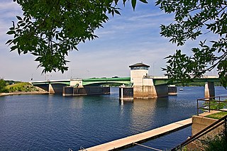
Caddo Lake Drawbridge in 2007
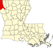
USA Louisiana location map.svg
Red pog.svg
LocationAcross Caddo Lake, next modern LA 538 bridge,
Mooringsport, Louisiana
Coordinates 32°41′47″N93°57′28″W / 32.69628°N 93.95785°W / 32.69628; -93.95785 Coordinates: 32°41′47″N93°57′28″W / 32.69628°N 93.95785°W / 32.69628; -93.95785
Arealess than one acre
Built1914
Architect Waddell & Harrington;
Midland Bridge Co.
NRHP reference No. 96001166 [1]
Added to NRHPOctober 18, 1996

The Historic Caddo Lake Drawbridge, also known as the Mooringsport Bridge, is a vertical-lift bridge that is listed on the U.S. National Register of Historic Places. It was built in 1914, to replace a ferry, by the Midland Bridge Company of Kansas City, Missouri, under authority of the Caddo Parish Police Jury. The lift span has been inoperable since the 1940s. [2]

This vehicular bridge illustrates the "Vertical-Lift" design of John Alexander Low Waddell of the firm of Waddell & Harrington. This design allowed the entire center span to lift in a vertical direction to allow tall oil equipment to pass through, especially Gulf Oil Company's pile driver. This design was invented in 1893 and was successfully introduced in Chicago with the South Halsted Street Bridge. The Caddo Lake Drawbridge is a direct descendant of this structure. [2]

In the summer of 1941, just prior to World War II, the United States Army held maneuvers in and around Mooringsport as a means of preparing the soldiers for war. During the maneuvers, Generals Dwight D. Eisenhower and George S. Patton came to Mooringsport and led the Red and Blue armies in the "capture" of the bridge. They also bombed the bridge with sacks of flour. [2]

In the mid-1940s, ownership of the bridge was transferred away from Caddo Parish to the Louisiana Department of Highways (LA Department of Transportation & Development, abbreviated as DOTD). Shortly after the transfer, the Department of Highways realized that there was no longer a need for the bridge to open. Consequently, the concrete counterweights were removed from the bridge's tower and dropped in the lake. [2]

In the late 1970s, due to the narrow width of the bridge, the flow of vehicular traffic was changed to one alternating lane. At this time, the DOTD determined that the useful life of the bridge had been exhausted and it was time to consider its replacement. In 1989, the DOTD received funds from the Federal Highway Administration for a bridge replacement project. The project called for the construction of a new two lane bridge approximately fifty feet to the east of the old bridge. The construction proposal also called for the old bridge to be destroyed when the new one was completed. A citizen's campaign was launched with involvement of Local, State and Federal officials and political leaders. The objective was to save the Historic Caddo Lake Drawbridge and convert its use into a pedestrian walkway, landmark, and tourist attraction. After two years of negotiations, the DOTD and the Federal Highway Administration agreed to use the funds appropriated for removing the structure to refurbish the bridge instead. This agreement was made with the stipulation that Caddo Parish agrees to assume ownership and liability. On June 26, 1991, the Caddo Parish Commissioners voted to accept the bridge into the Caddo Parish Department of Parks and Recreation. [2]

On July 24, 1991, The Historic American Engineering Record (U.S. Dept. of the Interior/National Park Service) rendered their evaluation of the bridge. The evaluation indicated that the bridge is nationally significant due to its designer, its unique design, and the fact that it is the sole surviving example of this bridge type in the State of Louisiana. With this determination, the bridge was eligible to be presented for listing on the National Register of Historic Places. Due to a unique state law that forbade the application process, this was delayed until ownership changed. [2]

After the bridge was cleaned, painted and barricaded to vehicular traffic, ownership of the bridge was transferred back to the Parish of Caddo on October 3, 1995. A rededication ceremony was held in Mooringsport later that month to mark the saving of the town's chief landmark and to honor those who had contributed to the endeavor. On June 4, 1996, a public hearing was held in Baton Rouge by the State's Review Committee regarding nomination of the bridge to the National Register of Historic Places. On October 18, 1996, the Historic Caddo Lake Drawbridge was officially entered into the National Register of Historic Places under the provisions of the National Historic Preservation Act of 1966. [1]

See also

Related Research Articles

<span class="mw-page-title-main">Mooringsport, Louisiana</span> Town in Louisiana, United States

Mooringsport is an incorporated municipality in the U.S. state of Louisiana, located in Caddo Parish. Part of the Shreveport–Bossier City metropolitan area and located approximately 18 miles (29 km) outside of the principal city of Shreveport, the town of Mooringsport had a population of 748 at the 2020 U.S. census.

<span class="mw-page-title-main">John Alexander Low Waddell</span> American civil engineer (1854–1938)

Dr. John Alexander Low Waddell was a Canadian-American civil engineer and prolific bridge designer, with more than a thousand structures to his credit in the United States, Canada, as well as Mexico, Russia, China, Japan, and New Zealand. Waddell’s work set standards for elevated railroad systems and helped develop materials suitable for large span bridges. His most important contribution was the development of the steam-powered high-lift bridge. Waddell was a widely respected writer on bridge design and engineering theory, as well as an advocate for quality in higher education engineering programs. The company he founded in 1887, 'J.A.L. Waddell, Consulting Engineer,' would eventually become the modern day Hardesty & Hanover, a leading moveable bridge engineering firm. Many of Waddell's surviving bridges are now considered historic landmarks.

<span class="mw-page-title-main">Stillwater Bridge (St. Croix River)</span> Bridge in Stillwater, Minnesota

The Stillwater Bridge is a vertical-lift bridge crossing the St. Croix River between Stillwater, Minnesota, and Houlton, Wisconsin. It formerly connected Minnesota State Highway 36 and Wisconsin Highway 64. Around 18,000 vehicles crossed the bridge daily. The new St. Croix Crossing bridge crossing the St. Croix river valley to the south of Stillwater replaced its purpose, having opened to highway traffic on August 2, 2017, leaving the Stillwater Lift Bridge to be preserved and to be converted to bicycle/pedestrian use.

<span class="mw-page-title-main">Huey P. Long Bridge (Jefferson Parish)</span> Road and railroad bridge in Louisiana, U.S.

The Huey P. Long Bridge, located in Jefferson Parish, Louisiana, is a cantilevered steel through-truss bridge that carries a two-track railroad line over the Mississippi River at mile 106.1, with three lanes of US 90 on each side of the central tracks. It is several kilometers upriver from the city of New Orleans. The East Bank entrance is at Elmwood, Louisiana, and the West Bank at Bridge City.

<span class="mw-page-title-main">Prescott Drawbridge</span> Bridge in Wisconsin and Denmark Township, Minnesota

The Prescott Drawbridge, also called the Point Douglas Drawbridge, is a steel girder bridge with a double-leaf bascule drawbridge section. The roadbed of the drawbridge span is a steel grate. The bridge carries U.S. 10 across the St. Croix River and connects Prescott, Wisconsin, with the Point Douglas park area of Denmark Township, Minnesota. This is the only highway drawbridge in the Minneapolis-St.Paul area with active traffic. It was completed in 1990 and replaced a rare regional example of a Waddell & Harrington vertical-lift bridge completed in 1922 that operated as a toll bridge from 1923 to 1946. The environmental impact statement, published in 1979, considered a higher level fixed bridge at this location.

<span class="mw-page-title-main">Louisiana Highway 23</span>

Louisiana Highway 23 is a north–south state highway in Louisiana that serves Plaquemines and Jefferson Parishes. It spans 74.0 miles (119.1 km) in roughly a southeast to northwest direction. It is known locally as Belle Chasse Highway, Lafayette Street, the West Bank Expressway, and Franklin Avenue.

<span class="mw-page-title-main">ASB Bridge</span> Bridge in and North Kansas City, Missouri

The Armour-Swift-Burlington (ASB) Bridge, also known as the North Kansas City Bridge and the LRC Bridge, is a rail crossing over the Missouri River in Kansas City, Missouri, that formerly handled automobile traffic.

<span class="mw-page-title-main">Louisiana Highway 14</span> Highway in Louisiana

Louisiana Highway 14 (LA 14) is a state highway located in southern Louisiana. It runs 100.10 miles (161.10 km) in an east–west direction from the junction of U.S. Highways 90 and 171 in Lake Charles to LA 182 in New Iberia.

<span class="mw-page-title-main">Louisiana Highway 24</span>

Louisiana Highway 24 (LA 24) is a state highway located in southeastern Louisiana. It runs 35.65 miles (57.37 km) in a general east–west direction from LA 20 in Schriever to LA 3235 in Larose.

<span class="mw-page-title-main">Kansas City Southern Railroad Bridge, Cross Bayou</span> Bridge in Shreveport, LA

The Kansas City Southern Railroad Bridge , in downtown Shreveport, Louisiana, is an "A" Truss bridge erected in its current location in 1926 and abandoned in the 1980s. Due to its national significance to the progress of American bridge design, and its rarity as one of only two known surviving examples, the structure was designated a National Historic Place in 1995.

<span class="mw-page-title-main">Midland Bridge Company</span>

The Midland Bridge Company is a firm based in Kansas City, Missouri, United States, that has built numerous bridges. Several of its works are listed on the U.S. National Register of Historic Places (NRHP).

<span class="mw-page-title-main">Louisiana Highway 87</span>

Louisiana Highway 87 (LA 87) is a state highway located in southern Louisiana. It runs 42.04 miles (67.66 km) in a northwest to southeast direction from LA 86 in New Iberia to the junction of two local roads north of Centerville.

<span class="mw-page-title-main">Waddell & Harrington</span>

Waddell & Harrington was an American engineering company that designed bridges from 1907 to 1915. It was formed in 1907 as a partnership of John Alexander Low Waddell (1854–1938) and John Lyle Harrington (1868–1942) and was based in Kansas City, Missouri, but had offices in Portland, Oregon, and Vancouver, British Columbia. The company designed more than 30 vertical-lift bridges for highways and railroads.

<span class="mw-page-title-main">Deweyville Swing Bridge</span> United States historic place

The Deweyville Swing Bridge, also known as Deweyville-Starks Swing Bridge and Sabine River Bridge, is a swing bridge which carries Texas State Highway 12 and Louisiana Highway 12 across the Sabine River at the Texas-Louisiana border. The bridge connects Deweyville, Texas to rural Calcasieu Parish, Louisiana, near the community of Starks. The Texas Highway Department and Louisiana Highway Commission built the bridge as a joint effort in 1936–38; the two highway departments used federal funding from Depression-era relief programs to complete the project. The bridge was one of four federally funded bridges between Texas and Louisiana built during the Great Depression. The swing bridge design, in which the center section of the bridge can rotate, allowed a variety of boats to pass by on the swift river. The bridge is the oldest surviving swing bridge of its design in Texas and one of three such bridges in the state.

Hardesty & Hanover is an American infrastructure engineering company specializing in the design and management of bridges and other transportation and architecture projects. The firm was founded in 1887 by John Alexander Low Waddell, a structural engineer who pioneered the design of large-scale moveable bridge. Originally incorporated in Kansas City, Missouri as J.A.L. Waddell, Consulting Engineer, the company was renamed throughout the early 20th century as Waddell added junior partners to the organization. In 1920, the firm moved its headquarters to New York City, where it would go on to design many important bridges int the area, such as Newark Bay Bridge (rail), the original Goethals Bridge, and Marine Parkway Bridge.

References

  1. 1 2 "National Register Information System". National Register of Historic Places . National Park Service. July 9, 2010.
  2. 1 2 3 4 5 6 National Register Staff (May 1996). "National Register of Historic Places Registration Form:Caddo Lake Bridge". National Park Service. Retrieved April 11, 2018. With seven photos from 1996.