National Register of Historic Places listings in Iberville Parish, Louisiana

Last updated

Location of Iberville Parish in Louisiana Map of Louisiana highlighting Iberville Parish.svg
Location of Iberville Parish in Louisiana

This is a list of the National Register of Historic Places listings in Iberville Parish, Louisiana.

Contents

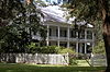
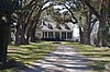
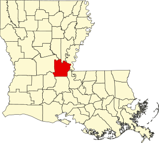
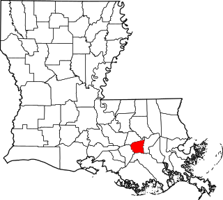
This is intended to be a complete list of the properties and districts on the National Register of Historic Places in Iberville Parish, Louisiana, United States. The locations of National Register properties and districts for which the latitude and longitude coordinates are included below, may be seen in a map. [1]

There are 24 properties and districts listed on the National Register in the parish.


    This National Park Service list is complete through NPS recent listings posted January 26, 2024. [2]

Map all coordinates using: OpenStreetMap

Current listings

[3] Name on the Register [4] ImageDate listed [5] Location City or townDescription
1 Bagatelle Plantation House
Bagatelle Plantation House Bagatelle Plantation, East River Road (moved to Iberville Parish), Donaldsonville vicinity (St. James Parish, Louisiana).jpg
Bagatelle Plantation House
May 9, 2007
(#07000424)
695 River Road (LA 991)
30°18′34″N91°11′08″W / 30.30957°N 91.18551°W / 30.30957; -91.18551 (Bagatelle Plantation House)
Sunshine House relocated from St. James Parish to just outside St. Gabriel.
2 Bayou Paul Colored School
Bayou Paul Colored School Bayou Paul School 2.JPG
Bayou Paul Colored School
January 26, 2016
(#15001000)
915 Bayou Paul Road
30°18′12″N91°06′46″W / 30.30344°N 91.11281°W / 30.30344; -91.11281 (Bayou Paul Colored School)
St. Gabriel Building was moved in Amanda Grace Memorial Park in 2006 and is currently used as the Bayou Paul Colored School

Museum. [6]

3 Bayou Plaquemine Lock
Bayou Plaquemine Lock Plaquemine Lock 2.JPG
Bayou Plaquemine Lock
May 19, 1972
(#72000554)
U.S. Government Reservation at the confluence of Bayou Plaquemine and the Mississippi River
30°17′33″N91°14′05″W / 30.29249°N 91.23471°W / 30.29249; -91.23471 (Bayou Plaquemine Lock)
Plaquemine Lock building is also part of Plaquemine Historic District since its creation on October 30, 1989. [7]
4 Carville Historic District
Carville Historic District CarvilleDistWM.JPG
Carville Historic District
November 18, 1992
(#92001529)
5445 Point Clair Road
30°11′52″N91°07′37″W / 30.19785°N 91.12694°W / 30.19785; -91.12694 (Carville Historic District)
St. Gabriel 
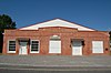
Federal and formerly state hospital addressing leprosy built mostly during 1939-1941 in the Carville neighborhood. Also includes Indian Camp Plantation House (1859) designed by Henry Howard.
5 Church of the Nativity
Church of the Nativity ChurchRosedale1.JPG
Church of the Nativity
August 11, 1982
(#82002775)
15615 Laurel Street
30°26′42″N91°27′08″W / 30.44493°N 91.45223°W / 30.44493; -91.45223 (Church of the Nativity)
Rosedale
6 Desobry Building
Desobry Building Desobry Building.jpg
Desobry Building
November 6, 1986
(#86003128)
58415 Court Street
30°17′04″N91°14′35″W / 30.28458°N 91.24309°W / 30.28458; -91.24309 (Desobry Building)
Plaquemine
7 Andrew H. Gay House
Andrew H. Gay House GayHouse11.JPG
Andrew H. Gay House
July 18, 1985
(#85001582)
1010 McDuffie Street
30°18′09″N91°14′25″W / 30.30254°N 91.24041°W / 30.30254; -91.24041 (Andrew H. Gay House)
Plaquemine
8 Homestead Plantation Complex
Homestead Plantation Complex HomesteadPlantation11.JPG
Homestead Plantation Complex
November 6, 1986
(#86003129)
Along Bayou Road (LA 3066), about 2.9 miles (4.7 km) southwest of Plaquemine
30°15′31″N91°16′01″W / 30.25857°N 91.26686°W / 30.25857; -91.26686 (Homestead Plantation Complex)
Plaquemine vicinityAlso known as Variety Plantation.
9 Iberville Parish Courthouse
Iberville Parish Courthouse OldPlaquCourtWM.JPG
Iberville Parish Courthouse
May 31, 1980
(#80001732)
57735 Main Street
30°17′30″N91°14′02″W / 30.29174°N 91.23393°W / 30.29174; -91.23393 (Iberville Parish Courthouse)
Plaquemine Greek Revival 1848 former parish courthouse serves today as the Iberville Museum. Also part of Plaquemine Historic District since its creation on October 30, 1989. [7]
10 Live Oaks Plantation
Live Oaks Plantation LiveOakPlantation11.JPG
Live Oaks Plantation
November 20, 1974
(#74000924)
Along LA 77, about 435 yards (398 m) northwest of intersection with LA 76
30°26′36″N91°27′23″W / 30.4433°N 91.45648°W / 30.4433; -91.45648 (Live Oaks Plantation)
Rosedale
11 Louis S. Lozano House April 21, 2021
(#100006452)
23730 Eden St.
30°17′15″N91°14′00″W / 30.2875°N 91.2333°W / 30.2875; -91.2333 (Louis S. Lozano House)
Plaquemine
12 Lucky Plantation House
Lucky Plantation House LuckyPlantation11.JPG
Lucky Plantation House
December 27, 2002
(#02001603)
1295 River Road (LA 75)
30°17′12″N91°11′52″W / 30.2867°N 91.19782°W / 30.2867; -91.19782 (Lucky Plantation House)
Sunshine Located just outside St. Gabriel.
13 Nottoway Plantation House
Nottoway Plantation House Nottoway plantation wc.jpg
Nottoway Plantation House
June 6, 1980
(#80001733)
31025 LA 1
30°11′11″N91°10′01″W / 30.18629°N 91.16691°W / 30.18629; -91.16691 (Nottoway Plantation House)
White Castle vicinity
14 Plaquemine High School
Plaquemine High School PlaqueHS12.JPG
Plaquemine High School
February 13, 1992
(#92000041)
58060 Plaquemine Street
30°17′20″N91°14′16″W / 30.28898°N 91.23784°W / 30.28898; -91.23784 (Plaquemine High School)
Plaquemine
15 Plaquemine Historic District
Plaquemine Historic District Old Square Plaquemine.jpg
Plaquemine Historic District
October 30, 1989
(#89001791)
Railroad Avenue, Main Street, Eden Street, Church Street, Plaquemine Street and Court Street
30°17′24″N91°14′11″W / 30.28993°N 91.23639°W / 30.28993; -91.23639 (Plaquemine Historic District)
Plaquemine Boundaries were increased on June 3, 2005.
16 Pierre Ernest Rivet House
Pierre Ernest Rivet House RivetHouse11.JPG
Pierre Ernest Rivet House
November 17, 2001
(#01001235)
58159 Plaquemine Street
30°17′16″N91°14′20″W / 30.28778°N 91.2389°W / 30.28778; -91.2389 (Pierre Ernest Rivet House)
Plaquemine
17 St. Basil's Academy
St. Basil's Academy St. Basil's Academy.jpg
St. Basil's Academy
October 5, 1982
(#82000439)
23515 Church Street
30°17′25″N91°14′00″W / 30.29026°N 91.23323°W / 30.29026; -91.23323 (St. Basil's Academy)
Plaquemine Also part of Plaquemine Historic District since its creation on October 30, 1989. [7]
18 St. Gabriel Roman Catholic Church
St. Gabriel Roman Catholic Church StGabeChurch1.JPG
St. Gabriel Roman Catholic Church
November 27, 1972
(#72000555)
3625 LA 75
30°15′16″N91°06′07″W / 30.25458°N 91.10204°W / 30.25458; -91.10204 (St. Gabriel Roman Catholic Church)
St. Gabriel
19 St. John Baptist Church
St. John Baptist Church St. John Dorseyville.JPG
St. John Baptist Church
January 21, 1994
(#93001549)
31925 Lacroix Road
30°10′38″N91°09′38″W / 30.17712°N 91.16065°W / 30.17712; -91.16065 (St. John Baptist Church)
Dorseyville
20 St. Louis Plantation
St. Louis Plantation St.LouisPlantation111.JPG
St. Louis Plantation
December 3, 1975
(#75000849)
Along St. Louis Road, about 325 yards (297 m) southwest of River Road (LA 405)
30°16′25″N91°12′44″W / 30.27371°N 91.21218°W / 30.27371; -91.21218 (St. Louis Plantation)
Plaquemine vicinity Antebellum home of Italianate and Greek Revival style, located on a working sugar cane plantation.
21 Schexnayder House
Schexnayder House Broussard Home (2).jpg
Schexnayder House
January 19, 1989
(#88003224)
610 Pecan Drive
30°18′43″N91°05′56″W / 30.31208°N 91.09879°W / 30.31208; -91.09879 (Schexnayder House)
St. Gabriel vicinity
22 J. Supple's Sons Mercantile Company, Ltd.
J. Supple's Sons Mercantile Company, Ltd. Supple Store.JPG
J. Supple's Sons Mercantile Company, Ltd.
May 10, 2005
(#05000406)
29801-29899 River Road (LA 405)
30°12′29″N91°10′12″W / 30.20792°N 91.1701°W / 30.20792; -91.1701 (J. Supple's Sons Mercantile Company, Ltd.)
Bayou Goula
23 Tally-Ho Plantation House
Tally-Ho Plantation House Tally Ho.JPG
Tally-Ho Plantation House
January 20, 1980
(#80001731)
Along River Road (LA 405)
30°12′11″N91°10′14″W / 30.20313°N 91.17042°W / 30.20313; -91.17042 (Tally-Ho Plantation House)
Bayou Goula
24 Trinity
Trinity Trinity Plantation.JPG
Trinity
January 7, 1994
(#93001493)
Along LA 77, about 0.3 miles (0.48 km) southeast of its junction with LA 76
30°26′13″N91°27′05″W / 30.43694°N 91.45133°W / 30.43694; -91.45133 (Trinity)
Rosedale

See also

Related Research Articles

<span class="mw-page-title-main">National Register of Historic Places listings in Caddo Parish, Louisiana</span>

This is a list of the National Register of Historic Places listings in Caddo Parish, Louisiana.

<span class="mw-page-title-main">National Register of Historic Places listings in East Baton Rouge Parish, Louisiana</span>

This is a list of the National Register of Historic Places listings in East Baton Rouge Parish, Louisiana.

<span class="mw-page-title-main">National Register of Historic Places listings in Natchitoches Parish, Louisiana</span>

This is a list of the National Register of Historic Places listings in Natchitoches Parish, Louisiana.

<span class="mw-page-title-main">National Register of Historic Places listings in Iberia Parish, Louisiana</span>

This is a list of the National Register of Historic Places listings in Iberia Parish, Louisiana.

<span class="mw-page-title-main">National Register of Historic Places listings in DeSoto Parish, Louisiana</span>

This is a list of the National Register of Historic Places listings in DeSoto Parish, Louisiana.

<span class="mw-page-title-main">National Register of Historic Places listings in Lafayette Parish, Louisiana</span>

This is a list of the National Register of Historic Places listings in Lafayette Parish, Louisiana.

<span class="mw-page-title-main">National Register of Historic Places listings in Avoyelles Parish, Louisiana</span>

This is a list of the National Register of Historic Places listings in Avoyelles Parish, Louisiana.

<span class="mw-page-title-main">National Register of Historic Places listings in St. James Parish, Louisiana</span>

This is a list of the National Register of Historic Places listings in St. James Parish, Louisiana.

<span class="mw-page-title-main">National Register of Historic Places listings in St. Martin Parish, Louisiana</span>

This is a list of the National Register of Historic Places listings in St. Martin Parish, Louisiana.

<span class="mw-page-title-main">National Register of Historic Places listings in St. Mary Parish, Louisiana</span>

This is a list of the National Register of Historic Places listings in St. Mary Parish, Louisiana.

<span class="mw-page-title-main">National Register of Historic Places listings in Calcasieu Parish, Louisiana</span>

This is a list of the National Register of Historic Places listings in Calcasieu Parish, Louisiana.

<span class="mw-page-title-main">National Register of Historic Places listings in Jefferson Parish, Louisiana</span>

This is a list of the National Register of Historic Places listings in Jefferson Parish, Louisiana.

<span class="mw-page-title-main">National Register of Historic Places listings in Jefferson Davis Parish, Louisiana</span>

This is a list of the National Register of Historic Places listings in Jefferson Davis Parish, Louisiana.

<span class="mw-page-title-main">National Register of Historic Places listings in St. John the Baptist Parish, Louisiana</span>

This is a list of the National Register of Historic Places listings in St. John the Baptist Parish, Louisiana.

<span class="mw-page-title-main">National Register of Historic Places listings in Vermilion Parish, Louisiana</span>

This is a list of the National Register of Historic Places listings in Vermilion Parish, Louisiana.

<span class="mw-page-title-main">National Register of Historic Places listings in Franklin Parish, Louisiana</span>

This is a list of the National Register of Historic Places listings in Franklin Parish, Louisiana.

<span class="mw-page-title-main">National Register of Historic Places listings in East Carroll Parish, Louisiana</span>

This is a list of the National Register of Historic Places listings in East Carroll Parish, Louisiana.

<span class="mw-page-title-main">National Register of Historic Places listings in Claiborne Parish, Louisiana</span>

This is a list of the National Register of Historic Places listings in Claiborne Parish, Louisiana.

<span class="mw-page-title-main">National Register of Historic Places listings in St. Charles Parish, Louisiana</span>

This is a list of the National Register of Historic Places listings in St. Charles Parish, Louisiana.

<span class="mw-page-title-main">National Register of Historic Places listings in Caldwell Parish, Louisiana</span>

This is a list of the National Register of Historic Places listings in Caldwell Parish, Louisiana.

References

  1. The latitude and longitude information provided in this table was derived originally from the National Register Information System, which has been found to be fairly accurate for about 99% of listings. Some locations in this table may have been corrected to current GPS standards.
  2. National Park Service, United States Department of the Interior, "National Register of Historic Places: Weekly List Actions", retrieved January 26, 2024.
  3. Numbers represent an alphabetical ordering by significant words. Various colorings, defined here, differentiate National Historic Landmarks and historic districts from other NRHP buildings, structures, sites or objects.
  4. "National Register Information System". National Register of Historic Places . National Park Service. March 13, 2009.
  5. The eight-digit number below each date is the number assigned to each location in the National Register Information System database, which can be viewed by clicking the number.
  6. "Bayou Paul Colored School" (PDF). State of Louisiana's Division of Historic Preservation. Retrieved June 19, 2018. with 12 photo and two maps
  7. 1 2 3 "Plaquemine Historic District" (PDF). State of Louisiana's Division of Historic Preservation. Retrieved June 20, 2018.