Plaquemine, Louisiana

Last updated

Plaquemine, Louisiana
Old Square Plaquemine.jpg
Old Square
Nickname: 
"City of Hospitality" [1]
Iberville Parish Louisiana Incorporated and Unincorporated areas Plaquemine Highlighted.svg
Location of Plaquemine in Iberville Parish, Louisiana
Louisiana in United States (US48).svg
Location of Louisiana in the United States
Coordinates: 30°17′03″N91°14′26″W / 30.28417°N 91.24056°W / 30.28417; -91.24056
Country United States
State Louisiana
Parish Iberville
Settled1775
Incorporated1838
Government
  MayorEdwin M. "Ed" Reeves Jr. (D) [2]
Area
[3]
  Total3.01 sq mi (7.78 km2)
  Land2.92 sq mi (7.57 km2)
  Water0.08 sq mi (0.21 km2)
Elevation
23 ft (7 m)
Population
 (2020)
  Total6,269
  Density2,144.71/sq mi (828.08/km2)
Time zone UTC-6 (CST)
  Summer (DST) UTC-5 (CDT)
ZIP code
70764
Area code 225
FIPS code 22-60880
Website www.plaquemine.org

Plaquemine is a city in and the parish seat of Iberville Parish, Louisiana, United States. [4] It is part of the Baton Rouge metropolitan statistical area. At the 2010 United States census, the population was 7,119; [5] the 2020 census determined its population was 6,269. [6]

Contents

History

Abandoned house in Plaquemine Plaquemine, Louisiana.jpg
Abandoned house in Plaquemine

Early inhabitants of the area were the Chitimacha people. Pierre Le Moyne d'Iberville claimed all of Louisiana in 1699 for King Louis XIV of France. [1] Plaquemine was settled by 1775 and named for the Native word Plakemine, which means persimmon. [7]

Due to its location at the juncture of the Bayou Plaquemine and the Mississippi River, the village soon began to prosper and grow, beginning a long history of prosperity. By 1838, the town was incorporated, [8] electing Zénon Labauve, for whom a street in New Orleans' Garden District is named, as its first mayor. [9]

Plaquemine continued to grow in the Antebellum era. Massive plantations were established in nearby regions, including St. Louis, Nottoway, and Belle Grove. The town has been the seat of Iberville Parish government since its incorporation. The second parish courthouse (c. 1906) on Railroad Avenue has been serving as City Hall since 1985. Plaquemine did not have a hospital until 1923. [10]

Plaquemine has been a Louisiana-designated Main Street City since 1993. [11] There are ten properties listed for Plaquemine on the National Register of Historic Places in Iberville Parish, Louisiana.

Geography

The city of Plaquemine is located at 30°17′3″N91°14′26″W / 30.28417°N 91.24056°W / 30.28417; -91.24056 (30.284044, −91.240485) [12] and has an elevation of 23 feet (7.0 m) above sea level. [13] Plaquemine is located at the junction of Bayou Plaquemine and the Mississippi River. The city itself is surrounded by farmland; beyond the farmland to the west lies nearly uninhabited swampland.

According to the United States Census Bureau, the city has a total area of 3.0 square miles (7.8 km2), of which 2.9 square miles (7.6 km2) are land and 0.1 square miles (0.2 km2), or 2.75%, are water. [5] It lies within the Baton Rouge metropolitan area.

Demographics

Historical population
CensusPop.Note
1860 1,663
1870 1,460−12.2%
1880 2,06141.2%
1890 3,22256.3%
1900 3,59011.4%
1910 4,95538.0%
1920 4,632−6.5%
1930 5,12410.6%
1940 5,049−1.5%
1950 5,74713.8%
1960 7,68933.8%
1970 7,7390.7%
1980 7,521−2.8%
1990 7,186−4.5%
2000 7,064−1.7%
2010 7,1190.8%
2020 6,269−11.9%
U.S. Decennial Census [14]

2020

Plaquemine, Louisiana – Racial and ethnic composition
Note: the US Census treats Hispanic/Latino as an ethnic category. This table excludes Latinos from the racial categories and assigns them to a separate category. Hispanics/Latinos may be of any race.
Race / Ethnicity (NH = Non-Hispanic)Pop 2000 [15] Pop 2010 [16] Pop 2020 [17] % 2000% 2010% 2020
White alone (NH)3,4433,2492,87448.74%45.64%45.84%
Black or African American alone (NH)3,4713,6152,95249.14%50.78%47.09%
Native American or Alaska Native alone (NH)1213140.17%0.18%0.22%
Asian alone (NH)1926330.27%0.37%0.53%
Pacific Islander alone (NH)2150.03%0.01%0.08%
Some Other Race alone (NH)00120.00%0.00%0.19%
Mixed race or Multiracial (NH)36441700.51%0.62%2.71%
Hispanic or Latino (any race)811712091.15%2.40%3.33%
Total7,0647,1196,269100.00%100.00%100.00%

The 2020 census determined 6,269 people lived in the city. [6] At the 2000 United States census, [18] there were 7,064 people, 2,593 households, and 1,846 families residing in the city.

At the 2019 American Community Survey, the racial and ethnic makeup was 54.9% Black and African American, 38.6% non-Hispanic white, 0.1% two or more races, and 6.4% Hispanic and Latin American of any race. [19] In 2000, the racial and ethnic makeup of the city was 49.26% White, 49.60% African American, 0.17% American Indian and Alaska Native, 0.27% Asian, 0.03% Pacific Islander, 0.08% from other races, and 0.58% from two or more races. Hispanic and Latin Americans of any race were 1.15% of the population.

In 2000, there were 2,593 households, out of which 29.7% had children under the age of 18 living with them, 44.0% were married couples living together, 22.7% had a female householder with no husband present, and 28.8% were non-families. 26.5% of all households were made up of individuals, and 10.5% had someone living alone who was 65 years of age or older. The average household size was 2.64 and the average family size was 3.21. In 2019, there were 2,578 households and an average of 2.54 people per household. [20]

From 2015 to 2019, the median household income was $44,457, and the per capita income was $24,871. [20] Males had a median income of $61,418 versus $27,875 for females. [21] Approximately 27.0% of the population lived at or below the poverty line. In 2000, the median income for a household in the city was $28,364, and the median income for a family was $32,971. Males had a median income of $34,868 versus $21,016 for females. The per capita income for the city was $14,066. About 23.6% of families and 24.4% of the population were below the poverty line, including 35.8% of those under age 18 and 17.5% of those age 65 or over.

Culture

Annual cultural events

Plaquemine's annual International Acadian Festival draws visitors from all over the world. [22] Local Mardi Gras celebrations also attract tourists. [23]

Tourism

Plaquemine is noted for a number of antebellum structures that survive within the city limits and along Bayou Road. One of the most noteworthy homes is St. Basil's, a riverfront mansion built by socialite physician Dr. John Scratchley in the 1850s. Now a private residence, the home retains the name St. Basil's from when it was a fashionable convent school. [24]

The Iberville Museum was built in 1949 as the Iberville Parish Courthouse. The building served as Plaquemine's first city hall, and was the city seat of government until 1985. It now serves as a parish museum, and the building is on the National Register of Historic Places. [25] [26]

The Plaquemine Lock, constructed from 1895 to 1909, was an important link between the Mississippi River and the Intracoastal Canal, of which Bayou Plaquemine served as its northern terminus. [27] Its design served as the prototype for the Panama Canal locks; the Plaquemine Lock was shut down in 1961. In 1974, the U.S. Army Corps of Engineers supervised the construction of the levee that runs across the mouth of Bayou Plaquemine at the Mississippi River. The Plaquemine Lock was placed on the National Register of Historic Places in 1972. The area now operates as a state park. [28] [29]

Education

Iberville Parish School Board operates public schools.

Plaquemine High School is outside the city limits, in an unincorporated area. [30] Mathematics, Science, and Arts Academy - West is outside the city limits, in an unincorporated area. [31]

Infrastructure

Transportation

Plaquemine is accessed by four highways: LA 3066, LA 75, LA 77, and the scenic LA 1. Other highways include LA 992 (Tenant Road) and LA 405. LA 3066 continues from Court Street to "Down the Bayou" neighborhoods. LA 75 accesses east over the Mississippi River via toll ferry to Saint Gabriel and leads southwest from Plaquemine, eventually reaching Bayou Pigeon. LA 77 starts around the Island Country Club and continues northwest to Maringouin. LA 1 runs north to Interstate 10/Baton Rouge and south to Donaldsonville. Plaquemine lacks public transportation and its residents rely completely on the use of the automobile.

National Guard

Plaquemine is the home of the 256th Brigade Special Troops Battalion, formerly known as the 1088th Engineer Battalion, [32] a unit made up of combat engineer, military intelligence, signal, military police and other supporting units. The 256th BSTB is part of the 256th Infantry Brigade of the Louisiana Army National Guard that served in Iraq from 2004 to 2005.

Notable people

Related Research Articles

<span class="mw-page-title-main">West Baton Rouge Parish, Louisiana</span> Parish in Louisiana, United States

West Baton Rouge Parish is one of the sixty-four parishes in the U.S. state of Louisiana. Established in 1807, its parish seat is Port Allen. With a 2020 census population of 27,199 residents, West Baton Rouge Parish is part of the Baton Rouge metropolitan statistical area.

<span class="mw-page-title-main">St. Mary Parish, Louisiana</span> Parish in Louisiana, United States

St. Mary Parish is a parish located in the U.S. state of Louisiana. As of the 2020 census, the population was 49,406. The parish seat is Franklin. The parish was created in 1811.

<span class="mw-page-title-main">Pointe Coupee Parish, Louisiana</span> Parish in Louisiana, United States

Pointe Coupee Parish is a parish located in the U.S. state of Louisiana. As of the 2020 census, the population was 20,758. The parish seat is New Roads.

<span class="mw-page-title-main">Plaquemines Parish, Louisiana</span> Parish in Louisiana, United States

Plaquemines Parish is a parish located in the U.S. state of Louisiana. With a population of 23,515 at the 2020 census, the parish seat is Pointe à la Hache and the largest community is Belle Chasse. The parish was formed in 1807.

<span class="mw-page-title-main">Jackson Parish, Louisiana</span> Parish in Louisiana, United States

Jackson Parish is a parish in the northern part of the U.S. state of Louisiana. As of the 2020 census, the population was 15,031. The parish seat is Jonesboro. The parish was formed in 1845 from parts of Claiborne, Ouachita, and Union Parishes. In the twentieth century, this part of the state had several small industrial mill towns, such as Jonesboro.

<span class="mw-page-title-main">Iberville Parish, Louisiana</span> Parish in Louisiana, United States

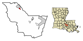
Iberville Parish is a parish located south of Baton Rouge in the U.S. state of Louisiana, formed in 1807. The parish seat is Plaquemine. The population was 30,241 at the 2020 census.

<span class="mw-page-title-main">East Baton Rouge Parish, Louisiana</span> Parish in Louisiana, United States

East Baton Rouge Parish is the most populous parish in the U.S. state of Louisiana. Its population was 456,781 at the 2020 census. The parish seat is Baton Rouge, Louisiana's state capital. East Baton Rouge Parish is located within the Greater Baton Rouge area.

<span class="mw-page-title-main">Ascension Parish, Louisiana</span> Parish in Louisiana, United States

Ascension Parish is a parish located in the U.S. state of Louisiana. As of the 2020 census, the population was 126,500. Its parish seat is Donaldsonville. The parish was created in 1807. Ascension Parish is part of the Baton Rouge metropolitan statistical area.

<span class="mw-page-title-main">Donaldsonville, Louisiana</span> City in Louisiana, United States

Donaldsonville is a city in, and the parish seat of Ascension Parish in the U.S. state of Louisiana. Located along the River Road of the west bank of the Mississippi River, it is a part of the Baton Rouge metropolitan statistical area. At the 2020 U.S. census, it had a population of 6,695.

<span class="mw-page-title-main">Grosse Tête, Louisiana</span> Village in Louisiana, United States

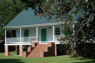
Grosse Tête is a village in Iberville Parish, Louisiana, United States. The population was 647 at the 2010 census, and 731 at the 2019 American Community Survey. The village name is French for "Big Head". Grosse Tête is part of the Baton Rouge metropolitan statistical area.

<span class="mw-page-title-main">Maringouin, Louisiana</span> Town in Louisiana, United States

Maringouin is a town in Iberville Parish, Louisiana, United States. The population was 1,098 at the 2010 census, down from 1,262 at the 2000 census. At the 2020 population estimates program, its population was 966. It is part of the Baton Rouge metropolitan statistical area.

<span class="mw-page-title-main">Rosedale, Louisiana</span> Village in Louisiana, United States

Rosedale is a village in Iberville Parish, Louisiana, United States. The population was 664 in 2020. It is part of the Baton Rouge metropolitan statistical area.

<span class="mw-page-title-main">St. Gabriel, Louisiana</span> City in Louisiana, United States

St. Gabriel is a city in Iberville Parish, Louisiana, United States. The city of St. Gabriel includes the Carville neighborhood and portions of Sunchine. Part of the Baton Rouge metropolitan statistical area, it had a population of 6,677 at the 2010 U.S. census, and 6,433 at the 2020 census.

<span class="mw-page-title-main">White Castle, Louisiana</span> Town in Louisiana, United States

White Castle is a town in Iberville Parish, Louisiana, United States. At the 2010 U.S. census the town population was 1,883, and 1,640 at the 2020 population estimates program. It is part of the Baton Rouge metropolitan area.

<span class="mw-page-title-main">Harvey, Louisiana</span> Census-designated place in Louisiana, United States

Harvey is a census-designated place (CDP) in Jefferson Parish, Louisiana, United States. Harvey is on the south side of the Mississippi River, within the New Orleans–Metairie–Kenner metropolitan statistical area. The majority-minority population was 20,348 at the 2010 census, down from 22,226 at the 2000 census. The 2020 census determined 22,236 people lived in the CDP.

<span class="mw-page-title-main">Terrytown, Louisiana</span> Census-designated place in Louisiana, United States

Terrytown is an unincorporated community and census-designated place (CDP) in Jefferson Parish, Louisiana, United States. It is on the "Westbank" of the Mississippi River. It is a suburb within the New Orleans–Metairie–Kenner metropolitan statistical area. The population was 23,319 at the 2010 census, and 25,278 in 2020.

<span class="mw-page-title-main">Baton Rouge metropolitan area</span> Metropolitan Statistical Area in Louisiana, United States

The Baton Rouge metropolitan statistical area, as defined by the United States Office of Management and Budget, or simply the Baton Rouge metropolitan area or Greater Baton Rouge, is a sprawling metropolitan statistical area surrounding the city of Baton Rouge. Including the western edge of the Florida Parishes regions, it is known as "Plantation Country", the "Capital Region", and "The 225". At the 2010 U.S. census, the metropolitan area had a population of 802,484, up from 705,973 in 2000. At the 2020 census, its population increased to 870,569, up from 2020 estimates at 858,571.

<span class="mw-page-title-main">New Orleans–Metairie–Slidell combined statistical area</span> Metropolitan area in Louisiana and Mississippi

The New Orleans–Metairie–Slidell combined statistical area is made up of nine parishes in southeastern Louisiana and one county in Mississippi. The statistical area consists of the New Orleans metropolitan statistical area (MSA), Slidell–Mandeville–Covington, LA MSA, Picayune micropolitan statistical area (μSA), and the Bogalusa μSA. As of the 2020 census estimates, the CSA had a population of 1,510,672. In 2023, the Office of Management and Budget updated the Core Based Statistical Areas, removing St. Tammany Parish from the New Orleans–Metairie MSA to create the Slidell–Mandeville–Covington MSA.

Bayou Goula is an unincorporated community and census-designated place (CDP) in Iberville Parish, Louisiana, United States. Its population was 514 in 2020.

Crescent is an unincorporated community and census-designated place in Iberville Parish, Louisiana, United States. It was first listed as a CDP in the 2010 Census with a population of 959. In 2020, its population was 811.

References

  1. 1 2 "Things to Do". City of Plaquemine. Archived from the original on December 2, 2013. Retrieved December 2, 2013.
  2. "City of Plaquemine Mayor". City of Plaquemine. Retrieved July 11, 2018.
  3. "2020 U.S. Gazetteer Files". United States Census Bureau. Retrieved March 20, 2022.
  4. "Find a County". National Association of Counties. Retrieved June 7, 2011.
  5. 1 2 "Geographic Identifiers: 2010 Census Summary File 1 (G001): Plaquemine city, Louisiana". American Factfinder. U.S. Census Bureau. Archived from the original on February 13, 2020. Retrieved April 3, 2018.
  6. 1 2 "QuickFacts: Plaquemine city, Louisiana". U.S. Census Bureau.
  7. "A bayou runs through it - Plaquemine, LA". National Geographic. Retrieved December 2, 2013.
  8. "CITY OF PLAQUEMINE". Iberville Parish. Archived from the original on October 22, 2013. Retrieved December 2, 2013.
  9. "The Bicentennial of the Louisiana Supreme Court". Louisiana Supreme Court. Retrieved December 2, 2013.
  10. Fama, Anthony (2004). "Part Five: The Plaquemine Sanitarium". Plaquemine: A Long, Long Time Ago. p. 25.
  11. "A bayou runs through it - Plaquemine, LA". National Geographic. Retrieved December 2, 2013.
  12. "US Gazetteer files: 2010, 2000, and 1990". United States Census Bureau. February 12, 2011. Retrieved April 23, 2011.
  13. "US Board on Geographic Names". United States Geological Survey. October 25, 2007. Retrieved January 31, 2008.
  14. "Census of Population and Housing". Census.gov. Retrieved June 4, 2015.
  15. "P004 Hispanic or Latino, and Not Hispanic or Latino by Race – 2000: DEC Summary File 1 – Old Plaquemine city, Louisiana". United States Census Bureau.
  16. "P2: Hispanic or Latino, and Not Hispanic or Latino by Race – 2010: DEC Redistricting Data (PL 94-171) – Plaquemine city, Louisiana". United States Census Bureau.
  17. "P2: Hispanic or Latino, and Not Hispanic or Latino by Race – 2020: DEC Redistricting Data (PL 94-171) – Plaquemine city, Louisiana". United States Census Bureau.
  18. "U.S. Census website". United States Census Bureau . Retrieved January 31, 2008.
  19. "2019 Demographic and Housing Estimates". data.census.gov. Retrieved August 5, 2021.
  20. 1 2 "QuickFacts Table". United States Census Bureau.
  21. "Geography Profile: Plaquemine city, Louisiana". data.census.gov. Retrieved August 5, 2021.
  22. "International Acadian Festival". Knights of Columbus Council 970. Retrieved December 2, 2013.
  23. "Mardi Gras Annual Parade". City of Plaquemine. Archived from the original on December 2, 2013. Retrieved December 2, 2013.
  24. "Plaquemine Lock State Historic Site". Louisiana State Parks. Archived from the original on December 3, 2013. Retrieved December 2, 2013.
  25. "Iberville Museum". The Museum Building. Archived from the original on July 7, 2010. Retrieved December 2, 2013.
  26. "Attractions". Iberville Parish. Retrieved December 2, 2013.
  27. "Plaquemine Lock State Historic Site". LOUISIANA DEPARTMENT OF CULTURE RECREATION AND TOURISM. Archived from the original on December 3, 2013. Retrieved December 2, 2013.
  28. "Plaquemine Lock State Historic Site". American Park Network. Retrieved December 2, 2013.
  29. "Plaquemine Lock State Historic Site". Word Press. Retrieved December 2, 2013.
  30. "Home". Plaquemine High School . Retrieved September 9, 2019. 59595 Belleview Drive, Plaquemine, LA 70764
  31. "Home". Mathematics, Science, and Arts Academy - West . Retrieved September 9, 2019. MSA-West Academy 57955 St Louis Rd, Plaquemine, LA 70764
  32. "256TH GUARDSMEN CONTINUE TO ASSIST WITH FLOOD RESPONSE". Louisiana National Guard. Retrieved December 2, 2013.
  33. "Bill Lee World Series Stats". Baseball Almanac. Retrieved December 2, 2013.
  34. "Brian Mitchell". databaseFootball.com. Retrieved December 2, 2013.
  35. "Clarence Williams". RedHotJazz. Archived from the original on January 7, 2010. Retrieved December 2, 2013.