Donaldsonville, Louisiana | |
---|---|
Coordinates: 30°6′0″N90°59′39″W / 30.10000°N 90.99417°W | |
Country | United States |
State | Louisiana |
Parish | Ascension |
Government | |
• Mayor | Leroy Sullivan, Sr. (elected 2012) |
Area | |
• Total | 3.80 sq mi (9.84 km2) |
• Land | 3.78 sq mi (9.78 km2) |
• Water | 0.02 sq mi (0.06 km2) |
Elevation | 26 ft (8 m) |
Population (2020) | |
• Total | 6,695 |
• Density | 1,772.10/sq mi (684.23/km2) |
Time zone | UTC-6 (CST) |
• Summer (DST) | UTC-5 (CDT) |
ZIP Code | 70346 |
Area code | 225 |
FIPS code | 22-21240 |
Website | http://www.donaldsonville-la.gov/ |
Donaldsonville (historically French : Lafourche-des-Chitimachas) [2] is a city in, and the parish seat of Ascension Parish in the U.S. state of Louisiana. [3] Located along the River Road of the west bank of the Mississippi River, it is a part of the Baton Rouge metropolitan statistical area. At the 2020 U.S. census, it had a population of 6,695. [4]
Donaldsonville's historic district has what has been described as the finest collection of buildings from the antebellum era to 1933, of any of the Louisiana river towns above New Orleans. [5] Union forces attacked the city, occupying it and several of the river parishes beginning in 1862. Fort Butler was built on the west bank of the Mississippi River. The fort was successfully defended on June 28, 1863, against a Confederate attack. This battle was one of the first occasions when free blacks and fugitive slaves fought as soldiers on behalf of the Union. The fort is listed on the National Register of Historic Places.
After the war, in 1868 Donaldsonville residents elected as mayor Pierre Caliste Landry, an attorney and Methodist minister; he was the first African American to be elected as mayor in the United States. [6]
The French were the first Europeans to colonize the area. They named the site Lafourche-des-Chitimachas, after the regional indigenous people and the local bayou, which they gave the same name. [7] They developed agriculture in the parish, mainly as sugar cane plantations worked by African slave labor.
Acadians, expelled by the British from Acadia in 1755, began to settle in the area from 1756 to 1785, where they developed small subsistence farms. Spanish Isleños also settled here. In 1772 when the territory was under Spanish rule, the militia constructed La Iglesia de la Ascensión de Nuestro Señor Jesucristo de Lafourche de los Chetimaches (the Ascension of Our Lord Catholic Church of Lafourche of the Chitimaches) to serve the area. The region returned later to French control for a time. [8] [9]
This area was included in the Louisiana Purchase in 1803 and became part of the United States. [8] Americans began to move into the area. Landowner and planter William Donaldson in 1806 commissioned the architect and planner, Barthelemy Lafon, to plan a new town at this site. It was renamed Donaldsonville after him. [10]
Donaldsonville was designated as the Louisiana capital (1829–1831), [11] as the result of conflict between the increasing number of Anglo-Americans, who deemed New Orleans "too noisy" and wanted to move the capital closer to their centers of population farther north in the state, and French Creoles, who wanted to keep the capital in a historically-French area.
As a result of the wealth planters gained from sugar and cotton commodity crops, they built fine mansions and other buildings in town during the antebellum years.
In the summer of 1862, Donaldsonville was bombarded by Union forces during the American Civil War as part of the Union's effort to gain control of the Mississippi River. The Union sent gunboats to the town and warned that if shots were fired, the Union Navy would strike the area for six miles to the south and nine miles to the north and destroy every building on every plantation. Admiral David G. Farragut destroyed much of the former capital city and put Ascension Parish under martial law, extending that to other River parishes.
Historian John D. Winters, in his The Civil War in Louisiana (1963), describes the scene:
The irate naval commander, Admiral Farragut, ordered the bombardment of Donaldsonville as soon as it could be evacuated. All of the citizens of Donaldsonville . . . "left their homes and went to the bayou . . . a detachment of Yankees went to shore with fire torches in hand." The hotels, warehouses, dwellings, and some of the most valuable buildings of the town were destroyed, Plantations . . . were bombarded and set afire. . . . A citizens' committee met and decided to ask Governor Moore to keep the [Confederate] Rangers from firing on Federal boats. These attacks did no real good and brought only crude reprisals against the innocent and helped to keep the Negroes stirred up. [12]
A citizen complained that the Rangers were useless and lawless, unable or unwilling to protect Confederate property. The citizen added that the Confederate people "could not fare worse were we surrounded by a band of Lincoln's mercenary hirelings. Our homes are entered and pillaged of everything that they [Rangers] see fit to appropriate to themselves." [13]
Union forces established a base at Donaldsonville for their occupation of river parishes. They took over some plantations, running them as U.S. government plantations to supply the forces and produce cotton. [14]
Many escaping slaves entered the Union lines to gain freedom. General Benjamin Butler had declared them "contrabands" of war and would not return them to slaveholders. They stayed and worked with Union forces, helping build the star-shaped Fort Butler in the town. A work of earth and wood, it was 381 feet long on the side by the Mississippi River, the other was protected by Bayou Lafourche, and the land sides by a deep moat. [14] A stockade surrounded the fort, which contained a high and thick earth parapet. There was further security from a strong log. The fort was built to accommodate 600 men, but in 1863 there were a small garrison of 180 Union men, commanded by Major Joseph Bullen of the 28th Maine; the forces were also made up of the 1st Louisiana Volunteers, a few Louisiana Native Guard convalescents, and some fugitive slaves. [14]
In June 1863, Confederate forces attacked Fort Butler at night. Led by General Tom Green, more than 1,000 Texas Rangers attacked the fort. Free blacks and fugitive slaves joined in the successful defense of the fort, in one of the first times they fought as soldiers on behalf of the Union. The New York Tribune wrote; "When action took place the negroes were stimulated to daring deeds." [14] Historian Don Frazier, wrote; "Not only did black hands build this citadel of freedom, they defended it to the death." [14] The Union kept control of the fort and ultimately won the war. It has been listed on the National Register of Historic Places.
After the war, Donaldsonville became the third-largest black community in the state, as more freedmen moved there to join those who had settled near Union forces for safety during the war. In 1868 the city elected the first African-American mayor in the United States, Pierre Caliste Landry, [6] a former slave who been educated in schools on a plantation owned by the Bringier family. After the war, he had advanced to become an attorney and state politician, serving in both houses of the legislature. He also became a Methodist Episcopal minister. [15]
Donaldsonville is the home of one of the oldest synagogue buildings still standing in the United States. [16] The wooden structure was built in 1872 by Congregation Bikur Cholim, which disbanded in the 1940s. It is now used as an Ace Hardware store. [17] The Jewish Cemetery dates to 1800s and is located on the corner of St. Patrick Street and Marchand Drive.
Mechanization of agriculture and other changes resulted in a major loss of population in Ascension Parish from 1900 to 1930, particularly from 1920 to 1930. This was the period of the Great Migration, when tens of thousands of African Americans left the rural South to go for opportunities in northern and midwestern cities. Such changes also drew off business from the parish seat. Ascension Parish lost more than 16% of its population in that decade. In the Great Depression, the area struggled economically.[ citation needed ]
Historian Sidney A. Marchand, who was also an attorney, was elected as mayor of the city and state legislator during that period. He served as a state Senator and contemporary of Governor Huey Long. During the mayoral administrations of Sidney A. Marchand and his son Sidney Marchand, Jr., they directed the construction of significant infrastructure in Donaldsonville (including about 12 miles of paving, and the still-extant sewerage system). Today the Donaldsonville Historic District has what is described as the "finest collection of buildings from the pre-Civil War to 1933 period" of rivertowns above New Orleans. [5] It is listed on the National Register of Historic Places.
In the 21st century, Donaldsonville is a small city with numerous historic sites. Since 2008, the River Road African American Museum, located in the city, has been included on the Louisiana African American Heritage Trail. [18] It also has parks, Civil War grounds, and shopping centers.
The official newspaper of the city is the Donaldsonville Chief , which has been published since 1871. [19]
According to the United States Census Bureau, the city has a total area of 2.5 square miles (6.5 km2), all land. Coming upriver on the Mississippi, Donaldsonville is the point of the first expanse of land beyond the narrow natural levee. The city sits approximately 25 feet above sea level. Donaldsonville is located where Bayou Lafourche, a distributary of the Mississippi River, formerly branched off until the entrance was dammed in 1905. [20]
Climate data for Donaldsonville, Louisiana (1991–2020 normals, extremes 1893–present) | |||||||||||||
---|---|---|---|---|---|---|---|---|---|---|---|---|---|
Month | Jan | Feb | Mar | Apr | May | Jun | Jul | Aug | Sep | Oct | Nov | Dec | Year |
Record high °F (°C) | 92 (33) | 88 (31) | 94 (34) | 97 (36) | 100 (38) | 102 (39) | 102 (39) | 104 (40) | 103 (39) | 100 (38) | 92 (33) | 90 (32) | 104 (40) |
Average high °F (°C) | 62.1 (16.7) | 66.1 (18.9) | 72.4 (22.4) | 78.4 (25.8) | 84.9 (29.4) | 89.2 (31.8) | 90.6 (32.6) | 90.8 (32.7) | 87.6 (30.9) | 80.3 (26.8) | 70.9 (21.6) | 64.4 (18.0) | 78.1 (25.6) |
Daily mean °F (°C) | 51.9 (11.1) | 55.6 (13.1) | 61.7 (16.5) | 67.8 (19.9) | 75.0 (23.9) | 80.4 (26.9) | 82.1 (27.8) | 81.9 (27.7) | 78.3 (25.7) | 69.4 (20.8) | 59.8 (15.4) | 54.1 (12.3) | 68.2 (20.1) |
Average low °F (°C) | 41.7 (5.4) | 45.2 (7.3) | 51.0 (10.6) | 57.1 (13.9) | 65.1 (18.4) | 71.6 (22.0) | 73.5 (23.1) | 73.1 (22.8) | 69.1 (20.6) | 58.6 (14.8) | 48.6 (9.2) | 43.7 (6.5) | 58.2 (14.6) |
Record low °F (°C) | 10 (−12) | 3 (−16) | 24 (−4) | 32 (0) | 41 (5) | 54 (12) | 59 (15) | 60 (16) | 43 (6) | 26 (−3) | 21 (−6) | 9 (−13) | 3 (−16) |
Average precipitation inches (mm) | 5.78 (147) | 4.11 (104) | 4.03 (102) | 4.88 (124) | 5.64 (143) | 6.97 (177) | 6.51 (165) | 6.37 (162) | 5.39 (137) | 4.65 (118) | 4.21 (107) | 4.86 (123) | 63.40 (1,610) |
Average snowfall inches (cm) | 0.0 (0.0) | 0.0 (0.0) | 0.0 (0.0) | 0.0 (0.0) | 0.0 (0.0) | 0.0 (0.0) | 0.0 (0.0) | 0.0 (0.0) | 0.0 (0.0) | 0.0 (0.0) | 0.0 (0.0) | 0.1 (0.25) | 0.1 (0.25) |
Average precipitation days (≥ 0.01 in) | 10.6 | 8.9 | 8.0 | 7.4 | 8.0 | 12.3 | 13.4 | 12.9 | 8.9 | 6.7 | 7.3 | 9.0 | 113.4 |
Average snowy days (≥ 0.1 in) | 0.0 | 0.0 | 0.0 | 0.0 | 0.0 | 0.0 | 0.0 | 0.0 | 0.0 | 0.0 | 0.0 | 0.2 | 0.2 |
Source: NOAA [21] [22] |
Census | Pop. | Note | %± |
---|---|---|---|
1860 | 1,475 | — | |
1870 | 1,573 | 6.6% | |
1880 | 2,600 | 65.3% | |
1890 | 3,121 | 20.0% | |
1900 | 4,105 | 31.5% | |
1910 | 4,090 | −0.4% | |
1920 | 3,745 | −8.4% | |
1930 | 3,788 | 1.1% | |
1940 | 3,889 | 2.7% | |
1950 | 4,150 | 6.7% | |
1960 | 6,082 | 46.6% | |
1970 | 7,367 | 21.1% | |
1980 | 7,901 | 7.2% | |
1990 | 7,949 | 0.6% | |
2000 | 7,605 | −4.3% | |
2010 | 7,436 | −2.2% | |
2020 | 6,695 | −10.0% | |
U.S. Decennial Census [23] |
Race | Number | Percentage |
---|---|---|
White (non-Hispanic) | 1,208 | 18.04% |
Black or African American (non-Hispanic) | 5,176 | 77.31% |
Native American | 1 | 0.01% |
Asian | 13 | 0.19% |
Other/Mixed | 136 | 2.03% |
Hispanic or Latino | 161 | 2.4% |
At the census of 2000, [25] there were 7,605 people, 2,656 households, and 1,946 families residing in the city. The population density was 2,986.9 inhabitants per square mile (1,153.2/km2). There were 2,948 housing units at an average density of 1,157.8 per square mile (447.0/km2). In 2020, the U.S. Census Bureau determined 6,695 people lived in the city, down from 7,436 in 2010. [4] There were 3,031 households and 1,846 families in the city at the 2020 census.
In 2000, the racial and ethnic makeup of the city was 29.82% White, 69.13% Black or African American, 0.12% Native American, 0.12% Asian, 0.37% from other races, and 0.45% from two or more races. Hispanic and Latino Americans of any race were 1.10% of the population. By 2020, the racial and ethnic makeup was 18.04% non-Hispanic white, 77.31% African American, 0.01% Native American, 0.19% Asian, 2.03% from two or more races, and 2.4% Hispanic or Latino of any race. [24]
In 2000, median income for a household in the city was $24,084, and the median income for a family was $29,408. Males had a median income of $31,849 versus $17,528 for females. The per capita income for the city was $12,009. About 32.8% of families and 34.8% of the population were below the poverty line, including 49.0% of those under age 18 and 22.2% of those age 65 or over. From 2014 to 2019, its median household income increased to $25,551 and $36,667 for families. [26] At the 2021 American Community Survey, the median income was $20,052, while families had a median income of $26,061, down from the 2000 census. [27]
St. John the Baptist Parish is a parish located in the U.S. state of Louisiana. At the 2020 census, the population was 42,477. The parish seat is Edgard, an unincorporated area, and the largest city is LaPlace, which is also unincorporated.
Lafourche Parish is a parish located in the south of the U.S. state of Louisiana. The parish seat is Thibodaux. The parish was formed in 1807. It was originally the northern part of Lafourche Interior Parish, which consisted of the present parishes of Lafourche and Terrebonne. Lafourche Parish was named after the Bayou Lafourche. City buildings have been featured in television and movies, such as in Fletch Lives, due to its architecture and rich history. At the 2020 census, its population was 97,557.
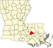
Ascension Parish is a parish located in the U.S. state of Louisiana. As of the 2020 census, the population was 126,500. Its parish seat is Donaldsonville. The parish was created in 1807. Ascension Parish is part of the Baton Rouge metropolitan statistical area.
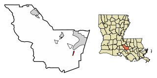
Labadieville is a census-designated place (CDP) in Assumption Parish, Louisiana, United States. The population was 1,854 at the 2010 census. It is part of the Pierre Part Micropolitan Statistical Area.
Plaquemine is a city in and the parish seat of Iberville Parish, Louisiana, United States. It is part of the Baton Rouge metropolitan statistical area. At the 2010 United States census, the population was 7,119; the 2020 census determined its population was 6,269.
White Castle is a town in Iberville Parish, Louisiana, United States. At the 2010 U.S. census the town population was 1,883, and 1,640 at the 2020 population estimates program. It is part of the Baton Rouge metropolitan area.
Thibodaux is a city in, and the parish seat of, Lafourche Parish, Louisiana, United States, along the banks of Bayou Lafourche in the northwestern part of the parish. The population was 15,948 at the 2020 census. Thibodaux is a principal city of the Houma–Bayou Cane–Thibodaux metropolitan statistical area.
Bayou Lafourche, originally called Chetimachas River or La Fourche des Chetimaches,, is a 106-mile-long (171 km) bayou in southeastern Louisiana, United States, that flows into the Gulf of Mexico. The bayou is flanked by Louisiana Highway 1 on the west and Louisiana Highway 308 on the east, and is known as "the longest Main Street in the world." It flows through parts of Ascension, Assumption, and Lafourche parishes. Today, approximately 300,000 Louisiana residents drink water drawn from the bayou.
Duncan Farrar Kenner was an American politician who served as a Deputy from Louisiana to the Provisional Congress of the Confederate States from 1861 to 1862. In 1864, he served as the chief diplomat from the Confederate States of America to Europe.
Henry S. Johnson was an American attorney and politician who served as the fifth Governor of Louisiana (1824–1828). He also served as a United States representative and as a United States senator.
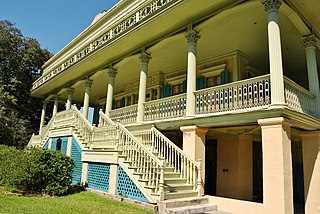
River Road African American Museum is a museum of culture and history in Donaldsonville, Louisiana, United States. Founded in 1994, it was among the first Louisiana museums to tell the story of Africans and African Americans, both slave and free. The museum notes their contributions to the River Road region, both before and after the American Civil War. Because of its significance, the museum was identified as one of the first 26 sites included by the state in 2008 on the Louisiana African American Heritage Trail.
Louisiana was a dominant population center in the southwest of the Confederate States of America, controlling the wealthy trade center of New Orleans, and contributing the French Creole and Cajun populations to the demographic composition of a predominantly Anglo-American country. In the antebellum period, Louisiana was a slave state, where enslaved African Americans had comprised the majority of the population during the eighteenth-century French and Spanish dominations. By the time the United States acquired the territory (1803) and Louisiana became a state (1812), the institution of slavery was entrenched. By 1860, 47% of the state's population were enslaved, though the state also had one of the largest free black populations in the United States. Much of the white population, particularly in the cities, supported slavery, while pockets of support for the U.S. and its government existed in the more rural areas.
The Battle of LaFourche Crossing was a battle in Lafourche Parish, Louisiana, United States and fought on June 20–21, 1863, during the American Civil War as part of a campaign known as Taylor's Operations in West Louisiana.
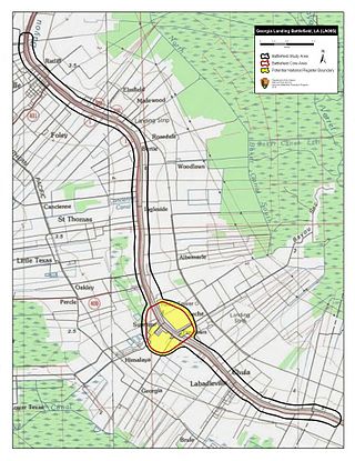
The Battle of Georgia Landing or Battle of Labadieville was fought between a Union Army force led by Brigadier General Godfrey Weitzel and a Confederate States Army force commanded by Brigadier General Alfred Mouton near Labadieville, Assumption Parish, Louisiana, during the American Civil War. After a sharp clash, the Union troops compelled Mouton's outnumbered force to retreat.
The Battle of Kock’s Plantation was a battle fought July 12–13, 1863, in Ascension Parish, Louisiana, during the American Civil War. It was part of a campaign entitled "Taylor's Operations in West Louisiana (1863)." The Confederate States Army victory left them in control of much of the interior of the Acadiana region.
The Second Battle of Donaldsonville was an American Civil War battle took place on June 28, 1863 in Ascension Parish, Louisiana.
Pierre Caliste Landry was born into slavery and went on to become an attorney, Methodist Episcopal minister, mayor, newspaper editor, and state legislator in Louisiana. He was elected in 1868 as mayor of Donaldsonville, making him the first African American to be elected mayor in the United States.
Trasimond Landry was an American politician. Between 1846 and 1850 he served as Lieutenant Governor of Louisiana.
The 2nd Louisiana Cavalry Regiment was a unit of mounted volunteers recruited in Louisiana that fought in the Confederate States Army during the American Civil War. Breazeale's Cavalry Battalion was formed in July 1862 and was augmented by five additional companies in September 1862 to form a regiment. It served for the entire war west of the Mississippi River in the Trans-Mississippi Department. The regiment fought at Georgia Landing, Fort Bisland, Irish Bend, and Brashear City in 1863 and Henderson's Hill and Mansfield in 1864. Afterward, the regiment fought in minor skirmishes before the Trans-Mississippi's final surrender on 26 May 1865.
The 5th Louisiana Field Battery was an artillery unit recruited from volunteers in Louisiana that fought in the Confederate States Army during the American Civil War. The Pelican Artillery organized on 31 October 1862, recruiting men mostly from St. James Parish, Louisiana. The battery first saw action in November 1862 against Union gunboats on Bayou Teche. In April 1863, the unit distinguished itself at Fort Bisland and it fought a skirmish at Vermillion Bayou a few days later. In July 1863, the battery fired on Federal shipping at Gaudet's Plantation near Donaldsonville, Louisiana, and fought at Kock's Plantation. In April 1864, it served during the Red River campaign and was present, but not engaged at the battles of Mansfield and Pleasant Hill. In May 1864, the unit was engaged at Mansura and Yellow Bayou. The battery surrendered in early June 1865 while at Tyler, Texas. A total of 183 men enlisted in the battery during the war; 2 were killed in action, 5 died from disease, and 1 drowned.