Jennings, Louisiana

Last updated

Jennings, Louisiana
City of Jennings
Jennings LA W. H. Tupper General Merchandise Museum2008.jpg
The front facade of the W. H. Tupper General Merchandise Museum, circa 2008
Motto: 
"Cradle of Louisiana Oil" [1]
Jefferson Davis Parish Louisiana Incorporated and Unincorporated areas Jennings Highlighted.svg
Location of Jennings in Jefferson Davis Parish, Louisiana.
Louisiana in United States (US48).svg
Location of Louisiana in the United States
Coordinates: 30°13′20″N92°39′25″W / 30.22222°N 92.65694°W / 30.22222; -92.65694
CountryUnited States
StateLouisiana
Parish Jefferson Davis
FoundedMay 2, 1888
Area
[2]
  Total10.58 sq mi (27.40 km2)
  Land10.56 sq mi (27.35 km2)
  Water0.02 sq mi (0.05 km2)
Elevation
26 ft (8 m)
Population
 (2020)
  Total9,837
  Density931.53/sq mi (359.67/km2)
Time zone UTC-6 (CST)
  Summer (DST) UTC-5 (CDT)
ZIP code
70546
Area code 337
FIPS code 22-38355
Website City of Jennings, Louisiana

Jennings is a city in, and the parish seat of, Jefferson Davis Parish, Louisiana, United States, [3] near Lake Charles. The population was 10,383 at the 2010 census, a small decline from the 2000 tabulation. [4]

Contents

Jennings is the principal city of the Jennings Micropolitan Statistical Area, which includes all of Jefferson Davis Parish. It is also part of the larger Lake Charles-Jennings Combined Statistical Area. It is also part of the large, 22-parish Acadiana region of the state, with a large Francophone population, many descended from early Acadian settlers.

History

For whom the town was named, Jennings McComb was an Irish contractor for the Southern Pacific Railroad. He built the Jennings depot on a divide peculiar to the southwest Louisiana. This became the center of new development based on the railroad. The first settler was recorded as A. D. McFarlain, who came in 1881 from St. Mary Parish and opened a store. McFarlain also became the first rice grower, postmaster, brickmaker, and builder in the community. Prospering with Jennings’ growth, McFarlain was considered one of the town's prominent businessmen and civic leaders.

The Jennings area attracted numerous wheat farmers from Iowa, Kansas, Nebraska, and other Midwestern states. The new settlers of southwest Louisiana were referred to as "Yankees" by the natives, who were of Acadian French and African-American descent. They had settled along the waterways in the parish, which they had relied on for transportation before the railroad. They fished in the bayous. The Cajuns gave appreciable aid to the settlers in homesteading and homemaking. The people grew rice, cotton, sweet potatoes, and corn. [5]

Sylvester L. Cary reached this area on February 7, 1883, from Iowa. He became known as the town's "father," as he persuaded other Iowans to relocate there. He said he was "seeking a home where there was neither winter nor mortgages." [5] So impressed was Cary by the fertile country around the Jennings depot that he shared his findings with others. He attracted fellow Midwesterners to southwest Louisiana by writing to friends in Iowa, extolling the area. When he returned to Iowa to pack up his family for the move to Jennings, he persuaded several neighbors preparing to migrate west, to follow him to Jennings and southwest Louisiana. [5]

Much of southwest Louisiana was developed by the North American Land and Timber Co., which owned large portions of land. Seaman A. Knapp, president of the Iowa State College of Agriculture, was engaged in 1885 to demonstrate the region's suitability for rice production. Knapp attracted a number of Iowans to settle the area. [6] The land company placed advertisements in newspapers published in the Midwestern states.

On May 2, 1888, the settlement of Jennings was incorporated as a village. In 1901, a fire destroyed a large portion of the wooden structures in Jennings. [5]

That same year, Jennings was the site of the first oil well to produce in Louisiana, revealing its first oil field. Oil brought a boom to the town for a period. When oil production declined, the basic agricultural economy of the parish supported the town. [5]

Geography

Jennings is located at 30°13′20″N92°39′25″W / 30.22222°N 92.65694°W / 30.22222; -92.65694 (30.222207, -92.656880) [7] and has an elevation of 26 feet (7.9 m). [8]

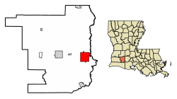
According to the United States Census Bureau, the city has a total area of 10.3 square miles (27 km2), of which 10.2 square miles (26 km2) is land and 0.04 square miles (0.10 km2) (0.19%) is water.

Climate

The climate in this area is characterized by hot, humid summers and generally mild to cool winters. According to the Köppen Climate Classification system, Jennings has a humid subtropical climate, abbreviated "Cfa" on climate maps. [9]

Climate data for Jennings, Louisiana (1991–2020 normals, extremes 1897–present)
MonthJanFebMarAprMayJunJulAugSepOctNovDecYear
Record high °F (°C)83
(28)
87
(31)
92
(33)
97
(36)
100
(38)
104
(40)
105
(41)
105
(41)
107
(42)
98
(37)
95
(35)
89
(32)
107
(42)
Mean daily maximum °F (°C)60.1
(15.6)
63.9
(17.7)
70.7
(21.5)
77.1
(25.1)
83.7
(28.7)
88.5
(31.4)
90.2
(32.3)
91.0
(32.8)
87.7
(30.9)
80.4
(26.9)
70.2
(21.2)
62.5
(16.9)
77.2
(25.1)
Daily mean °F (°C)50.9
(10.5)
54.5
(12.5)
61.1
(16.2)
67.5
(19.7)
74.8
(23.8)
80.3
(26.8)
81.9
(27.7)
82.1
(27.8)
78.3
(25.7)
69.5
(20.8)
59.7
(15.4)
53.1
(11.7)
67.8
(19.9)
Mean daily minimum °F (°C)41.6
(5.3)
45.1
(7.3)
51.5
(10.8)
57.8
(14.3)
65.9
(18.8)
72.0
(22.2)
73.7
(23.2)
73.2
(22.9)
69.0
(20.6)
58.7
(14.8)
49.2
(9.6)
43.6
(6.4)
58.4
(14.7)
Record low °F (°C)10
(−12)
9
(−13)
20
(−7)
32
(0)
39
(4)
46
(8)
59
(15)
59
(15)
43
(6)
27
(−3)
22
(−6)
10
(−12)
9
(−13)
Average precipitation inches (mm)6.29
(160)
4.25
(108)
3.77
(96)
4.79
(122)
5.52
(140)
6.61
(168)
5.36
(136)
6.80
(173)
5.80
(147)
4.73
(120)
4.85
(123)
4.74
(120)
63.51
(1,613)
Average snowfall inches (cm)0.0
(0.0)
0.0
(0.0)
0.0
(0.0)
0.0
(0.0)
0.0
(0.0)
0.0
(0.0)
0.0
(0.0)
0.0
(0.0)
0.0
(0.0)
0.0
(0.0)
0.0
(0.0)
0.1
(0.25)
0.1
(0.25)
Average precipitation days (≥ 0.01 in)11.610.28.97.88.012.214.212.89.87.88.911.3123.5
Average snowy days (≥ 0.1 in)0.00.00.00.00.00.00.00.00.00.00.00.10.1
Source: NOAA [10] [11]

Demographics

Historical population
CensusPop.Note
1890 412
1900 1,539273.5%
1910 3,925155.0%
1920 3,824−2.6%
1930 4,0365.5%
1940 7,34381.9%
1950 9,66331.6%
1960 11,88723.0%
1970 11,783−0.9%
1980 12,4015.2%
1990 11,305−8.8%
2000 10,986−2.8%
2010 10,383−5.5%
2020 9,837−5.3%
U.S. Decennial Census [12]
Jennings racial composition as of 2020 [13]
RaceNumberPercentage
White (non-Hispanic)6,36464.69%
Black or African American (non-Hispanic)2,78228.28%
Native American 310.32%
Asian 300.3%
Pacific Islander 30.03%
Other/Mixed 3873.93%
Hispanic or Latino 2402.44%

As of the 2020 United States census, there were 9,837 people, 3,862 households, and 2,390 families residing in the city.

Notable people

Education

Jefferson Davis Parish Public Schools operates public schools serving Jennings. The schools serving Jennings, all within the city, include Jennings Elementary School (pk-6), and Jennings High School (7-12) .

Bethel Christian School is a PreK-12 Christian school located in unincorporated Jefferson Davis Parish, near Jennings. [16]

Jefferson Davis Parish Library operates the Headquarters Branch at 118 West Plaquemine Street in Jennings. In addition the City of Jennings operates the Jennings Carnegie Public Library at 303 North Cary Avenue. [17]

Our Lady Immaculate (OLI) is a Catholic school serving grades PREK-8.

Related Research Articles

<span class="mw-page-title-main">Jefferson Davis Parish, Louisiana</span> Parish in Louisiana, United States

Jefferson Davis Parish is a parish located in the U.S. state of Louisiana. As of the 2020 census, the population was 32,250. The parish seat is Jennings. Jefferson Davis Parish is named after the president of the Confederacy during the American Civil War, Jefferson Davis. It is located in southwestern Louisiana and forms a part of the Acadiana region.

<span class="mw-page-title-main">Cameron Parish, Louisiana</span> Parish in Louisiana, United States

Cameron Parish is a parish in the southwest corner of the U.S. state of Louisiana. As of the 2020 census, the population was 5,617. The parish seat is Cameron. Although it is the largest parish by area in Louisiana, it has the second-smallest population in the state, ahead of only Tensas. Cameron Parish is part of the Lake Charles metropolitan statistical area.

<span class="mw-page-title-main">Calcasieu Parish, Louisiana</span> Parish in Louisiana, United States

Calcasieu Parish is a parish located on the southwestern border of the U.S. state of Louisiana. As of the 2020 census, the population was 216,785. The parish seat is Lake Charles.

<span class="mw-page-title-main">Crowley, Louisiana</span> City in Louisiana, United States

Crowley is a city in, and the parish seat of, Acadia Parish in the U.S. state of Louisiana. At the 2020 United States census, Crowley had a population of 11,710. Crowley is the principal city of the Crowley micropolitan statistical area, which includes all of Acadia Parish. It is also part of the larger Lafayette–Acadiana combined statistical area.

<span class="mw-page-title-main">Iowa, Louisiana</span> Town in Louisiana, United States

Iowa is a town in Calcasieu Parish, Louisiana, United States. The population was 3,436 in 2020. It is part of the Lake Charles metropolitan statistical area.

<span class="mw-page-title-main">Sulphur, Louisiana</span> City in Louisiana, United States

Sulphur is a city in Calcasieu Parish, Louisiana, United States. The population was 21,809 in 2020. Sulphur is part of the Lake Charles metropolitan statistical area.

<span class="mw-page-title-main">Vinton, Louisiana</span> Town in Louisiana, United States

Vinton is a town in Calcasieu Parish, Louisiana, United States. The population was 3,400 in 2020. It is part of the Lake Charles metropolitan statistical area.

<span class="mw-page-title-main">Homer, Louisiana</span> Town in Louisiana, United States

Homer is a town in and the parish seat of Claiborne Parish in northern Louisiana, United States. Named for the Greek poet Homer, the town was laid out around the Courthouse Square in 1850 by Frank Vaughn. The present-day brick courthouse, built in the Greek Revival style of architecture, is one of only four pre-Civil War courthouses in Louisiana still in use. The building, completed in 1860, was accepted by the Claiborne Parish Police Jury on July 20, 1861, at a cost of $12,304.36, and is on the National Register of Historic Places. The other courthouses are in St. Francisville, St. Martinville and Thibodaux.

<span class="mw-page-title-main">New Iberia, Louisiana</span> City in Louisiana, United States

New Iberia is the largest city in and parish seat of Iberia Parish in the U.S. state of Louisiana. The city of New Iberia is located approximately 21 miles southeast of Lafayette, and forms part of the Lafayette metropolitan statistical area in the region of Acadiana. The 2020 United States census tabulated a population of 28,555. New Iberia is served by Amtrak’s Sunset Limited, operating between Los Angeles and New Orleans. New Iberia has a major four lane highway, being U.S. 90, and has its own general aviation airfield, Acadiana Regional Airport. Scheduled passenger and cargo airline service is available via the nearby Lafayette Regional Airport located adjacent to U.S. 90 in Lafayette.

<span class="mw-page-title-main">Elton, Louisiana</span> Town in Louisiana, United States

Elton is a town in Jefferson Davis Parish, Louisiana, United States. The population was 992 at the 2020 census, down from 1,128 at the 2010 census. It is part of the Jennings Micropolitan Statistical Area.

<span class="mw-page-title-main">Fenton, Louisiana</span> Village in Louisiana, United States

Fenton is a village in Jefferson Davis Parish, Louisiana, United States. The population was 226 at the 2020 census. It is notable for being a speed trap along U.S. Route 165.

<span class="mw-page-title-main">Lake Arthur, Louisiana</span> Town in Louisiana, United States

Lake Arthur is a town in Jefferson Davis Parish, Louisiana, United States. The population was 2,738 at the 2010 census, down from 3,007 at the 2000 census. It is part of the Jennings Micropolitan Statistical Area. The current mayor is Sampson “poncho” Lejeune.

<span class="mw-page-title-main">Welsh, Louisiana</span> Town in Louisiana, United States

Welsh is a town in Jefferson Davis Parish, Louisiana. The population was 3,226 at the time of the 2010 census. It is part of the Jennings Micropolitan Statistical Area.

<span class="mw-page-title-main">Kenner, Louisiana</span> City in Louisiana, United States

Kenner is a city in the U.S. state of Louisiana. It is the most populous city in Jefferson Parish, and is the largest incorporated suburban city of New Orleans. The population was 66,448 at the 2020 census, making it the sixth-most populous city in Louisiana.

<span class="mw-page-title-main">Scott, Louisiana</span> City in Louisiana, United States

Scott is the fourth largest municipality in Lafayette Parish, Louisiana, United States. The population was 8,614 as of the 2010 U.S. census, and 8,119 at the 2020 census, up from 7,870 at the 2000 census. Scott is a suburban community of Lafayette and is part of the Lafayette metropolitan statistical area in Acadiana.

<span class="mw-page-title-main">St. Charles Parish, Louisiana</span> Parish in Louisiana, United States

St. Charles Parish is a parish located in the U.S. state of Louisiana. At the 2020 census, its population was 52,549. The parish seat is Hahnville and the most populous community is Luling.

<span class="mw-page-title-main">Lake Charles metropolitan area</span> Metropolitan Statistical Area in Louisiana, United States

The Lake Charles metropolitan statistical area is a metropolitan area in the Acadiana region of southwest Louisiana that covers three parishes—Calcasieu, Cameron, and Jefferson Davis. According to a 2019 census estimate, the MSA had a population of 210,409. It is also part of the larger Lake Charles–DeRidder combined statistical area which had a population of 241,777 in 2019. The Lake Charles MSA also shares borders with the Beaumont–Port Arthur metropolitan area to the west. Metropolitan Lake Charles, the principal city, is commonly referred to as the Lake Area.

<span class="mw-page-title-main">Lake Charles–DeRidder CSA</span> Combined Statistical Area in Louisiana, United States

The Lake Charles–DeRidder combined statistical area is made up of four parishes in southwestern Louisiana. The statistical area consists of the Lake Charles Metropolitan Statistical Area and the DeRidder Micropolitan Statistical Area. The largest principal city is Lake Charles, and the smaller principal city is Jennings. As of the 2010 census, the CSA had a population of 231,201. A July 1, 2019 estimate placed the population at 241,777.

Lacassine is an unincorporated community and census-designated place (CDP) in Jefferson Davis Parish in the U.S. state of Louisiana. As of the 2010 census the population was 480.

References

  1. "City of Jennings, Louisiana". City of Jennings, Louisiana. Retrieved August 26, 2012.
  2. "2020 U.S. Gazetteer Files". United States Census Bureau. Retrieved March 20, 2022.
  3. "Find a County". National Association of Counties. Archived from the original on May 9, 2015. Retrieved June 7, 2011.
  4. "Jennings (city), Louisiana". quickfacts.census.gov. Archived from the original on December 4, 2012. Retrieved November 26, 2012.
  5. 1 2 3 4 5 library.mcneese.edu "THE HISTORY OF JENNINGS, LOUISIANA"
  6. Letter of Nancy B. Vezinet, archivist for the State of Louisiana, 24 March 1982. She excerpted the relevant passages from Cities and Towns of Louisiana by Clare D'Artois Leeper. Cf. also A. A. Wentz, "The Vinton-Lake Charles Colony," Vinton (Ia.) Eagle, 14 April 1896.
  7. "US Gazetteer files: 2010, 2000, and 1990". United States Census Bureau. February 12, 2011. Archived from the original on May 27, 2002. Retrieved April 23, 2011.
  8. "US Board on Geographic Names". United States Geological Survey. October 25, 2007. Retrieved January 31, 2008.
  9. Climate Summary for Jennings, Louisiana
  10. "NowData - NOAA Online Weather Data". National Oceanic and Atmospheric Administration. Retrieved August 27, 2021.
  11. "Station: Jennings, LA". U.S. Climate Normals 2020: U.S. Monthly Climate Normals (1991-2020). National Oceanic and Atmospheric Administration. Retrieved August 27, 2021.
  12. "Census of Population and Housing". Census.gov. Archived from the original on April 26, 2015. Retrieved June 4, 2015.
  13. "Explore Census Data". data.census.gov. Retrieved December 29, 2021.
  14. "Pat Rapp Stats". Baseball Almanac. Retrieved November 26, 2012.
  15. "Guy Sockrider". obits.dignitymemorial.com. February 27, 2011. Retrieved November 1, 2014.
  16. "Contact Information." Bethel Christian School. Retrieved on November 26, 2012. "15147 Hwy 102 Jennings, LA 70546"
  17. "Carnegie Public Library: Archived 2008-09-29 at the Wayback Machine ." City of Jennings. Accessed September 22, 2008.