Elton, Louisiana | |
|---|---|
Town | |
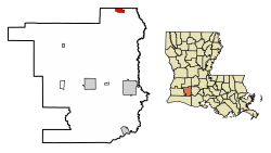 Location of Elton in Jefferson Davis Parish, Louisiana | |
 Location of Louisiana in the United States | |
| Coordinates: 30°28′51″N92°41′47″W / 30.48083°N 92.69639°W | |
| Country | United States |
| State | Louisiana |
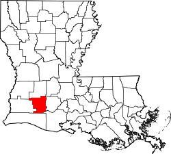
| Parish | Jefferson Davis |
| Government | |
| • Mayor | Mike Pierrotti (R) |
| Area | |
• Total | 1.66 sq mi (4.30 km2) |
| • Land | 1.66 sq mi (4.30 km2) |
| • Water | 0.00 sq mi (0.00 km2) |
| Elevation | 49 ft (15 m) |
| Population (2020) | |
• Total | 992 |
| • Density | 597.23/sq mi (230.60/km2) |
| Time zone | UTC-6 (CST) |
| • Summer (DST) | UTC-5 (CDT) |
| ZIP code | 70532 [2] |
| Area code | 337 |
| FIPS code | 22-23620 |
| Website | townofelton |
Elton is a town in Jefferson Davis Parish, Louisiana, United States. The population was 992 at the 2020 census, [3] down from 1,128 at the 2010 census. [4] It is part of the Jennings Micropolitan Statistical Area.