White Castle, Louisiana

Last updated

White Castle, Louisiana
Town
Iberville Parish Louisiana Incorporated and Unincorporated areas White Castle Highlighted.svg
Location of White Castle in Iberville Parish, Louisiana
Louisiana in United States (US48).svg
Location of Louisiana in the United States
Coordinates: 30°10′07″N91°08′48″W / 30.16861°N 91.14667°W / 30.16861; -91.14667
CountryUnited States
StateLouisiana
Parish Iberville
Government
  MayorJohn Morris (D)
Area
[1]
  Total0.74 sq mi (1.91 km2)
  Land0.73 sq mi (1.90 km2)
  Water0.00 sq mi (0.01 km2)
Elevation
23 ft (7 m)
Population
 (2020)
  Total1,722
  Density2,349.25/sq mi (907.21/km2)
Time zone UTC-6 (CST)
  Summer (DST) UTC-5 (CDT)
ZIP code
70788 [2]
Area code 225
FIPS code 22-81375
Website towcla.com

White Castle is a town in Iberville Parish, Louisiana, United States. At the 2010 U.S. census the town population was 1,883, [3] and 1,640 at the 2020 population estimates program. [4] It is part of the Baton Rouge metropolitan area.

Contents

History

The town of White Castle was carved out of the George Wailes plantation "White Castle". The 1883 Charles H. Dickinson Survey of several parishes of Louisiana shows the White Castle Plantation property. Nearby is the antebellum mansion Nottoway Plantation.

White Castle was established as a town in the 1880s with the influx of people and business brought by the logging industry in the cypress swamps of the area. When the cypress wood was depleted, the main economic activity reverted to the sugar cane industry which had been established in the latter part of the 18th century.

Individual plantation sugar mills gave way to larger mills servicing many plantations. By 1970, White Castle had three major sugar mills, Cora Texas, Cedar Grove, and Catherine/Supples. Only one, Cora Texas located just south of White Castle on LA 1, is still in operation. Antebellum plantation homes in the area are Nottoway, Tally-ho, among others.

People living in the unincorporated areas of Samstown, Lone Star, Belle Grove, Dorseyville, and as far away as Bayou Goula helped support White Castle businesses through the years. At one time, there were three car dealerships, Dufour Chevrolet, White Castle Motor company (Ford), and Dixie Sales and Service(Chrysler/Plymouth); three drug stores, Hebert's, Viallon's, and Bajon's; Weils and Shaheens clothing stores; Agosta Shoe Store; Eskine's Jewelry; and two lumber yards, Baudoin's and Tassin's. Engolio's Maggio's, Chiaramonte, Dominic Sciortino, Tina's, Forte's, and Landry's were used for grocery shopping. Big-screen entertainment was provided by Castle Theater until 1959, when it was closed.

During the 1950s, the chemical industry entered the area, congregating around the Mississippi River between Baton Rouge and New Orleans. This industry brought economic growth which took White Castle into the 1980s. Companies establishing chemical plants in the area near White Castle were Dow Chemical north of Plaquemine, Georgia-Gulf and Hercules north of White Castle, and Ciba-Geigy on the east bank of the Mississippi.

Population levels have remained between 1,900 and 2,200 for the last forty years, within the White Castle town limits. The surrounding unincorporated areas have seen an increase in population.

Geography

White Castle is located in southeastern Iberville Parish at 30°10′7″N91°8′48″W / 30.16861°N 91.14667°W / 30.16861; -91.14667 (30.168503, −91.146708), [5] on the south bank of the Mississippi River. Louisiana Highway 1 passes through the town, leading northwest 10 miles (16 km) to Plaquemine, the Iberville Parish seat and southeast the same distance to Donaldsonville, the seat of Ascension Parish.

According to the United States Census Bureau, the town of White Castle has a total area of 0.73 square miles (1.9 km2), of which 1.9 acres (7,876 m2), or 0.41%, are water. [3]

Demographics

Historical population
CensusPop.Note
1890 603
1900 1,850206.8%
1910 2,28923.7%
1920 1,566−31.6%
1930 1,499−4.3%
1940 1,69212.9%
1950 1,8398.7%
1960 2,25322.5%
1970 2,206−2.1%
1980 2,160−2.1%
1990 2,102−2.7%
2000 1,946−7.4%
2010 1,883−3.2%
2020 1,722−8.6%
U.S. Decennial Census [6]
White Castle racial composition as of 2020 [7]
RaceNumberPercentage
White (non-Hispanic)1257.26%
Black or African American (non-Hispanic)1,55390.19%
Native American 20.12%
Other/Mixed 291.68%
Hispanic or Latino 130.75%

As of the 2020 United States census, there were 1,722 people, 672 households, and 421 families residing in the town. The racial and ethnic makeup of the town was 83.4% Black and African American, 14.2% non-Hispanic white, and 2.3% two or more races at the 2019 American Community Survey. [8] The median household income was $30,729 and 27.3% of the population lived at or below the poverty line.

At the 2000 United States census, [9] there were 1,946 people, 699 households, and 513 families residing in the town. The population density was 2,592.0 inhabitants per square mile (1,000.8/km2). There were 762 housing units at an average density of 1,014.9 per square mile (391.9/km2). The racial makeup of the town was 76.82% African American, 22.56% White, 0.21% Asian, 0.10% from other races, and 0.31% from two or more races. Hispanic or Latino of any race were 1.44% of the population.

There were 699 households, out of which 38.3% had children under the age of 18 living with them, 36.6% were married couples living together, 30.8% had a female householder with no husband present, and 26.6% were non-families. 24.7% of all households were made up of individuals, and 12.4% had someone living alone who was 65 years of age or older. The average household size was 2.78 and the average family size was 3.34.

In the town, the population was spread out, with 31.7% under the age of 18, 10.2% from 18 to 24, 26.0% from 25 to 44, 18.2% from 45 to 64, and 13.9% who were 65 years of age or older. The median age was 32 years. For every 100 females, there were 82.2 males. For every 100 females age 18 and over, there were 75.3 males.

The median income for a household in the town was $19,435, and the median income for a family was $24,236. Males had a median income of $25,170 versus $15,885 for females. The per capita income for the town was $12,246. About 25.4% of families and 31.3% of the population were below the poverty line, including 43.0% of those under age 18 and 18.8% of those age 65 or over.

Economy

White Castle has no White Castle restaurants. White Castle is home to Cora Texas Sugar Mill, one of the largest in the United States. The Nottoway Plantation and Resort just outside of town is another part of the local economy.

Notable people

See also

Related Research Articles

<span class="mw-page-title-main">West Baton Rouge Parish, Louisiana</span> Parish in Louisiana, United States

West Baton Rouge Parish is one of the sixty-four parishes in the U.S. state of Louisiana. Established in 1807, its parish seat is Port Allen. With a 2020 census population of 27,199 residents, West Baton Rouge Parish is part of the Baton Rouge metropolitan statistical area.

<span class="mw-page-title-main">Plaquemines Parish, Louisiana</span> Parish in Louisiana, United States

Plaquemines Parish is a parish located in the U.S. state of Louisiana. With a population of 23,515 at the 2020 census, the parish seat is Pointe à la Hache and the largest community is Belle Chasse. The parish was formed in 1807.

<span class="mw-page-title-main">Iberville Parish, Louisiana</span> Parish in Louisiana, United States

Iberville Parish is a parish located south of Baton Rouge in the U.S. state of Louisiana, formed in 1807. The parish seat is Plaquemine. The population was 30,241 at the 2020 census.

<span class="mw-page-title-main">Iberia Parish, Louisiana</span> Parish in Louisiana, United States

Iberia Parish is a parish located in the U.S. state of Louisiana. At the 2020 census, it had a population of 69,929; the parish seat is New Iberia.

<span class="mw-page-title-main">Catahoula Parish, Louisiana</span> Parish in Louisiana, United States

Catahoula Parish is a parish in the U.S. state of Louisiana. As of the 2020 census, the population was 8,906. Its seat is Harrisonburg, on the Ouachita River. The parish was formed in 1808, shortly after the United States acquired this territory in the Louisiana Purchase of 1803.

<span class="mw-page-title-main">Blanchard, Louisiana</span> Town in Louisiana, United States

Blanchard is the suburban town in, and the second-largest municipality by population of Caddo Parish in the U.S. state of Louisiana. With a population of 3,538 at the 2020 U.S. census, it is part of the Shreveport–Bossier City metropolitan statistical area.

<span class="mw-page-title-main">Jeanerette, Louisiana</span> City in Louisiana, United States

Jeanerette is a city in Iberia Parish, Louisiana, United States. Known as "Sugar City", it had a population of 5,530 at the 2010 census, a decrease of 467 from the 2000 tabulation of 5,997. It is two thirds African American, many of them Creoles of color. Jeanerette is the part of the Lafayette metropolitan statistical area; its parish is also one of the 22 included in the Acadiana region, which has had a high proportion of Francophones.

<span class="mw-page-title-main">Grosse Tête, Louisiana</span> Village in Louisiana, United States

Grosse Tête is a village in Iberville Parish, Louisiana, United States. The population was 647 at the 2010 census, and 731 at the 2019 American Community Survey. The village name is French for "Big Head". Grosse Tête is part of the Baton Rouge metropolitan statistical area.

<span class="mw-page-title-main">Maringouin, Louisiana</span> Town in Louisiana, United States

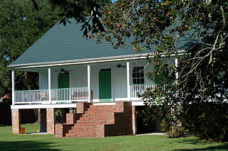
Maringouin is a town in Iberville Parish, Louisiana, United States. The population was 1,098 at the 2010 census, down from 1,262 at the 2000 census. At the 2020 population estimates program, its population was 966. It is part of the Baton Rouge metropolitan statistical area.

<span class="mw-page-title-main">Plaquemine, Louisiana</span> City in Louisiana, United States

Plaquemine is a city in and the parish seat of Iberville Parish, Louisiana, United States. It is part of the Baton Rouge metropolitan statistical area. At the 2010 United States census, the population was 7,119; the 2020 census determined its population was 6,269.

<span class="mw-page-title-main">St. Gabriel, Louisiana</span> City in Louisiana, United States

St. Gabriel is a city in Iberville Parish, Louisiana, United States. The city of St. Gabriel includes the Carville neighborhood and portions of Sunchine. Part of the Baton Rouge metropolitan statistical area, it had a population of 6,677 at the 2010 U.S. census, and 6,433 at the 2020 census.

<span class="mw-page-title-main">Belle Chasse, Louisiana</span> Census-designated place in Louisiana, United States

Belle Chasse is a census-designated place (CDP) in Plaquemines Parish, Louisiana, United States, on the west bank of the Mississippi River. Belle Chasse is part of the Greater New Orleans metropolitan area. The population was 10,579 at the 2020 United States census. Belle Chasse is the largest community in Plaquemines Parish. It is home to Naval Air Station Joint Reserve Base New Orleans, a Naval Air Station for the U.S. Navy Reserve.

Boothville-Venice is a former census-designated place (CDP) in Plaquemines Parish, Louisiana, United States, which includes the unincorporated communities of Boothville, Venice, and Orchard. The population was 2,220 at the 2000 census. For the 2010 census, Boothville-Venice was split into the CDPs of Boothville and Venice.

<span class="mw-page-title-main">Buras-Triumph, Louisiana</span> Former Census-designated place in Louisiana, United States

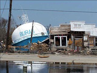
Buras-Triumph is a former census-designated place in Plaquemines Parish, Louisiana, United States. The population was 3,358 at the 2000 census. For the 2010 census, Buras-Triumph was split into the CDPs of Buras and Triumph. On the peninsula, Buras has been located higher, with Triumph located southeast of Buras.

<span class="mw-page-title-main">Gramercy, Louisiana</span> Town in Louisiana, United States

Gramercy is a town in the U.S. state of Louisiana, in St. James Parish. It is part of the New Orleans Metropolitan Area. The population was 3,613 at the time of the 2010 U.S. census and 3,188 according to the 2020 population estimates program.

<span class="mw-page-title-main">Lutcher, Louisiana</span> Town in Louisiana, United States

Lutcher is a town in St. James Parish, Louisiana, United States, on the east bank of the Mississippi River. It is part of the New Orleans Metropolitan Area. The population was 3,559 at the 2010 U.S. census, and 3,127 at the 2020 population estimates program.

<span class="mw-page-title-main">Edgard, Louisiana</span> CDP in Louisiana, United States

Edgard is a census-designated place (CDP) in, and the parish seat of, St. John the Baptist Parish, Louisiana, United States. The population was 2,637 at the 2000 census and 1,948 in 2020. It is part of the New Orleans–Metairie–Kenner Metropolitan Statistical Area. Edgard is part of the German Coast of Louisiana.

<span class="mw-page-title-main">Fort Johnson North, Louisiana</span> Census-designated place in Louisiana, United States

Fort Johnson North is a census-designated place (CDP) in Vernon Parish, Louisiana, United States. The population was 3,279 at the 2000 census. It is part of the Fort Johnson South Micropolitan Statistical Area.

<span class="mw-page-title-main">Port Allen, Louisiana</span> City in Louisiana, United States

Port Allen is a city in, and the parish seat of, West Baton Rouge Parish, Louisiana, United States. Located on the west bank of the Mississippi River, it is bordered by Interstate 10 and US Highway 190. The population was 4,939 in 2020. It is part of the Baton Rouge metropolitan statistical area.

<span class="mw-page-title-main">Baton Rouge metropolitan area</span> Metropolitan Statistical Area in Louisiana, United States

The Baton Rouge metropolitan statistical area, as defined by the United States Office of Management and Budget, or simply the Baton Rouge metropolitan area or Greater Baton Rouge, is a sprawling metropolitan statistical area surrounding the city of Baton Rouge. Including the western edge of the Florida Parishes regions, it is known as "Plantation Country", the "Capital Region", and "The 225". At the 2010 U.S. census, the metropolitan area had a population of 802,484, up from 705,973 in 2000. At the 2020 census, its population increased to 870,569, up from 2020 estimates at 858,571.

References

  1. "2020 U.S. Gazetteer Files". United States Census Bureau. Retrieved March 20, 2022.
  2. "White Castle LA ZIP Code". zipdatamaps.com. 2023. Retrieved June 16, 2023.
  3. 1 2 "Geographic Identifiers: 2010 Census Summary File 1 (G001): White Castle town, Louisiana". American Factfinder. U.S. Census Bureau. Archived from the original on February 13, 2020. Retrieved April 4, 2018.
  4. "City and Town Population Totals: 2010-2020". United States Census Bureau. Retrieved August 5, 2021.
  5. "US Gazetteer files: 2010, 2000, and 1990". United States Census Bureau. February 1, 2011. Retrieved April 23, 2011.
  6. "Census of Population and Housing". Census.gov. Retrieved June 4, 2015.
  7. "Explore Census Data". data.census.gov. Retrieved December 29, 2021.
  8. "Geography Profile: White Castle town, Louisiana". data.census.gov. Retrieved August 5, 2021.
  9. "U.S. Census website". United States Census Bureau . Retrieved January 31, 2008.
  10. Doucet, Jacques. "LSU's Martin Carries Flag For White Castle & Tigers". wafb.com. Retrieved March 24, 2020.