Saunderton is a village and former civil parish, now in the parish of Bledlow-cum-Saunderton, Buckinghamshire, England. It is in the Saunderton Valley in the Chiltern Hills. It is 2 miles (3 km) southwest of Princes Risborough, Saunderton Lee, about 2 miles (3 km) further south and a residential area on the A4010 road around Saunderton railway station, it is 5 miles (8 km) northwest of High Wycombe.

Asgarby is a village in the civil parish of Asgarby and Howell, in the North Kesteven district of Lincolnshire, England. It is situated on the A17 Boston to Newark road, 3 miles (5 km) east from Sleaford and 2 miles (3 km) north-west from Heckington. In 1921 the parish had a population of 63. On 1 April 1931 the parish was abolished to form "Asgarby and Howell".

Blyton is a village and civil parish within the West Lindsey district of Lincolnshire, England. It is situated approximately 4 miles (6 km) north-east from Gainsborough. From Blyton the village of Laughton lies to the north, and Pilham to the south-east, while the course of the River Trent runs nearby to the west.

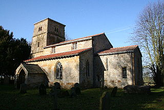
Braceby is a village in the civil parish of Braceby and Sapperton, in the South Kesteven district of Lincolnshire, England. The village includes a roadside nature reserve sheltering 250 species of plant life.

Cadney is a village and civil parish in the North Lincolnshire district, in the county of Lincolnshire, England. The population of the parish at the 2011 census was 459. It is situated 3 miles (5 km) south from the town of Brigg.
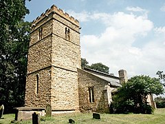
Gunby is a village and former civil parish, now in the parish of Gunby and Stainby, in the South Kesteven district of Lincolnshire, England. It is situated close to the borders with Leicestershire and Rutland, and 9 miles (14 km) south from Grantham, and 2 miles (3 km) west from the A1 road. In 1921 the parish had a population of 119. On 1 April 1931 the parish was abolished and merged with Stainby to form "Gunby and Stainby".

Sapperton is a village in the civil parish of Braceby and Sapperton, in the South Kesteven district of Lincolnshire, England. The nearest town is Grantham, 6 miles (9.7 km) to the west. Adjacent villages include Braceby, Pickworth and Ropsley. In 1921 the parish had a population of 46. On 1 April 1931 the parish was abolished and merged with Braceby to form "Braceby and Sapperton".

Saltby is a village and former civil parish, now in the parish of Sproxton, in the Melton borough of Leicestershire, England. It lies close to the River Eye and the border with Lincolnshire. There are approximately 65 properties (2021) within the village. In 1931 the parish had a population of 170. On 1 April 1936 the parish was abolished and merged with Sproxton.

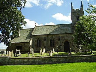
Pointon is a village in the civil parish of Pointon and Sempringham, in the South Kesteven district of Lincolnshire, England. In 2021 the parish of "Pointon and Sempringham" has a population of 533. The majority of the parish's population live in Pointon. It is situated 7 miles (11.3 km) north of Bourne.

Cuxwold is a village and former civil parish, now in the parish of Swallow, in the West Lindsey district of Lincolnshire, England. It lies in the Lincolnshire Wolds, 4 miles (6 km) east from Caistor and 10 miles (16 km) south-west from Grimsby. In 1931 the parish had a population of 98. On 1 April 1936 the parish was abolished and merged with Swallow.

Ruckland is a village in the civil parish of Maidenwell, and about 6 miles (10 km) south from the town of Louth, in the East Lindsey district, in the county of Lincolnshire, England. It lies in the Lincolnshire Wolds, a designated Area of Outstanding Natural Beauty. In 1931 the parish had a population of 21. On 1 April 1936 the parish was abolished to form Maidenwell.

Scrafield is a hamlet and a deserted medieval village (DMV) in the civil parish of Mareham on the Hill, in the East Lindsey district, in the county of Lincolnshire, England. It is approximately 4 miles (6.4 km) south-east of the town of Horncastle. In 1931 the parish had a population of 24. On 1 April 1936 the parish was abolished to form Mareham on the Hill.

Doddington is a village in the civil parish of Doddington and Whisby, in the North Kesteven district of Lincolnshire, England. The population of the civil parish of "Doddington and Whisby" at the 2011 census was 319. The parish of Doddington and Whisby lies 5 miles (8 km) west of Lincoln, to the north of the A46 road, and is bounded to its west by Nottinghamshire. It includes the hamlet of Whisby, and parts of the Whisby Moor Nature Reserve.

Croxby is a hamlet and former civil parish, now in the parish of Thoresway, in the West Lindsey district of Lincolnshire, England. It is situated approximately 5 miles (8.0 km) east from the town of Caistor. In 1931 the parish had a population of 77. On 1 April 1936 the parish was abolished and merged with Thoresway.

Evedon is a village in the civil parish of Ewerby and Evedon, in the North Kesteven district of Lincolnshire, England. It is situated 2 miles (3.2 km) north-east from the town of Sleaford.

Farforth or Farforth-cum-Maidenwell is a hamlet in the East Lindsey district of Lincolnshire, England. It is in the civil parish of Maidenwell, and approximately 6 miles (10 km) south of the town of Louth.
Kingerby is a village and former civil parish, now in the parish of Osgodby, in the West Lindsey district of Lincolnshire, England. It is situated 5 miles (8.0 km) north west from the town of Market Rasen. The hamlet of Bishop Bridge lies about 1.5 miles (2.4 km) to the south-west. In 1931 the parish had a population of 75. On 1 April 1936 the parish was abolished to form Osgodby.

Usselby is a hamlet in civil parish of Osgodby, in the West Lindsey district of Lincolnshire, England. It is approximately 3 miles (5 km) north-west from the town of Market Rasen. In 1931 the parish had a population of 54. On 1 April 1936 the parish was abolished to form Osgodby.

Kirkby cum Osgodby, sometimes called Kirkby, is hamlet and former civil parish, now in the parish of Osgodby, in the West Lindsey district of Lincolnshire, England. It lies 3.5 miles (5.6 km) north-west from Market Rasen and less than 1 mile (1.6 km) west from the village of Osgodby.

Thornton le Moor is a village in the civil parish of Owersby, in the West Lindsey district of Lincolnshire, England, situated approximately 5 miles (8 km) south-west from the town of Caistor. In 1931 the parish had a population of 70. On 1 April 1936 the parish was abolished and merged with Owersby.