
Queen Square is a 2.4 hectares Georgian square in the centre of Bristol, England. Following the 1831 riot, Queen Square declined through the latter part of the 19th century, was threatened with a main line railway station, but then bisected by a dual carriageway in the 1930s. By 1991 20,000 vehicles including scheduled buses were crossing the square every day, and over 30% of the buildings around it were vacant.
Richard Shackleton Pope was a British architect working mainly in Bristol. His father was a clerk of works for Sir Robert Smirke, and Pope succeeded him, also working for C.R. Cockerell. He moved to Bristol to work on one of Cockerell's projects and decided to settle in the city, where he became District Surveyor from 1831 to 1874, with considerable influence over building works.

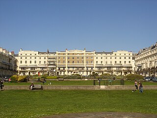
Brunswick Town is an area in Hove, in the city of Brighton and Hove, England. It is best known for the Regency architecture of the Brunswick estate.

Portland Square is a Grade I listed square in the St Paul's area of Bristol.

There are 100 Grade I listed buildings in Bristol, England according to Bristol City Council. The register includes many structures which for convenience are grouped together in the list below.
There are 212 Grade II* listed buildings in Bristol, England.
There are many Grade II listed buildings in Bristol, United Kingdom.

Berkeley Square is an area close to Park Street in the Clifton area of Bristol that includes buildings and a central area of greenery.

Royal York Crescent is a major residential street in Clifton, Bristol. It overlooks much of the docks, and much of the city can be seen from it. It also joins Clifton Village at one end. It is one of the most expensive streets in the city.

There are 24 Grade I listed buildings in the city of Brighton and Hove, England. The city, on the English Channel coast approximately 52 miles (84 km) south of London, was formed as a unitary authority in 1997 by the merger of the neighbouring towns of Brighton and Hove. Queen Elizabeth II granted city status in 2000.

Amon Henry Wilds was an English architect. He was part of a team of three architects and builders who—working together or independently at different times—were almost solely responsible for a surge in residential construction and development in early 19th-century Brighton, which until then had been a small but increasingly fashionable seaside resort on the East Sussex coast. In the 1820s, when Wilds, his father Amon Wilds and Charles Busby were at their most active, nearly 4,000 new houses were built, along with many hotels, churches and venues for socialising; most of these still survive, giving Brighton a distinctive Regency-era character, and many are listed buildings.

Norfolk Crescent in Bath, Somerset, England was built between c.1793 and c.1822 and has been designated as a Grade II* listed building. The original design was by John Palmer, but minor alterations were later made by John Pinch.

As of February 2001, there were 1,124 listed buildings with Grade II status in the English city of Brighton and Hove. The total at 2009 was similar. The city, on the English Channel coast approximately 52 miles (84 km) south of London, was formed as a unitary authority in 1997 by the merger of the neighbouring towns of Brighton and Hove. Queen Elizabeth II granted city status in 2000.
Regency Square is a large early 19th-century residential development on the seafront in Brighton, part of the British city of Brighton and Hove. Conceived by speculative developer Joshua Hanson as Brighton underwent its rapid transformation into a fashionable resort, the three-sided "set piece" of 69 houses and associated structures was built between 1818 and 1832. Most of the houses overlooking the central garden were complete by 1824. The site was previously known, briefly and unofficially, as Belle Vue Field.
Montpelier Crescent is a mid 19th-century crescent of 38 houses in the Montpelier suburb of the English coastal city of Brighton and Hove. Built in five parts as a set-piece residential development in the rapidly growing seaside resort, the main part of the crescent was designed between 1843 and 1847 by prominent local architect Amon Henry Wilds and is one of his most distinctive compositions. Extra houses were added at both ends of the crescent in the mid-1850s. Unlike most other squares, terraces and crescents in Brighton, it does not face the sea—and the view it originally had towards the South Downs was blocked within a few years by a tall terrace of houses opposite. Montpelier was an exclusive and "salubrious" area of Brighton, and Montpelier Crescent has been called its "great showpiece". Wilds's central section has been protected as Grade II* listed, with the later additions listed separately at the lower Grade II. The crescent is in one of the city's 34 conservation areas, and forms one of several "outstanding examples of late Regency architecture" within it.
As of February 2001, there were 1,124 listed buildings with Grade II status in the English city of Brighton and Hove. The total at 2009 was similar. The city, on the English Channel coast approximately 52 miles (84 km) south of London, was formed as a unitary authority in 1997 by the merger of the neighbouring towns of Brighton and Hove. Queen Elizabeth II granted city status in 2000.

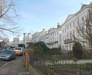
Cornwallis Crescent is a late 18th-century crescent of 24 Georgian town houses, located between York Gardens and Cornwallis Avenue in the Clifton area of Bristol. The postcode is within the Hotwells and Harbourside ward and electoral division, which is in the constituency of Bristol West.

Lloyd Square, a garden square in Clerkenwell, central London, It consists of Grade II Listed houses making up a square of unique and noted character in central London. Its nearest tube stations are Kings Cross, Russell Square, Farringdon, Angel and Chancery Lane. The square has mature trees, flowers, beds and shrubs and is lined by neat hedges and formal railings, which are listed.

As of February 2001, there were 1,124 listed buildings with Grade II status in the English city of Brighton and Hove. The total at 2009 was similar. The city, on the English Channel coast approximately 52 miles (84 km) south of London, was formed as a unitary authority in 1997 by the merger of the neighbouring towns of Brighton and Hove. Queen Elizabeth II granted city status in 2000.
As of February 2001, there were 1,124 listed buildings with Grade II status in the English city of Brighton and Hove. The total at 2009 was similar. The city, on the English Channel coast approximately 52 miles (84 km) south of London, was formed as a unitary authority in 1997 by the merger of the neighbouring towns of Brighton and Hove. Queen Elizabeth II granted city status in 2000.


