Calhoun, Tennessee

Last updated

Calhoun, Tennessee
Calhoun-townhall-po-tn1.jpg
McMinn County Tennessee Incorporated and Unincorporated areas Calhoun Highlighted 4710440.svg
Location of Calhoun in McMinn County, Tennessee.
Coordinates: 35°17′45″N84°44′53″W / 35.29583°N 84.74806°W / 35.29583; -84.74806
Country United States
State Tennessee
County McMinn
Founded1820
Incorporated1961 [1]
Named for John C. Calhoun
Area
[2]
  Total1.25 sq mi (3.23 km2)
  Land1.19 sq mi (3.08 km2)
  Water0.06 sq mi (0.15 km2)
Elevation
712 ft (217 m)
Population
 (2020) [3]
  Total536
  Density451.56/sq mi (174.29/km2)
Time zone UTC-5 (Eastern (EST))
  Summer (DST) UTC-4 (EDT)
ZIP code
37309
Area code 423
FIPS code 47-10440 [4]
GNIS feature ID1279325 [5]

Calhoun is a town in McMinn County, Tennessee, United States. It is part of the Athens Micropolitan Statistical Area . The population was estimated at 536 in 2020. [6]

Contents

History

The area where Calhoun is located was settled by John Walker (c. 1770-1834), a part-Cherokee grandson of Nancy Ward and a prominent figure in the formation of McMinn County. Walker helped contract the Cherokee Turnpike Company in 1808 to maintain a road between Knoxville and Georgia. What is now Cahoun began around 1808, when Walker established a ferry across the Hiwassee River between the present locations of Calhoun and Charleston. [7] In 1819, Walker helped negotiate the Calhoun Treaty, where the Cherokee ceded the remaining lands between the Hiwassee River and the Little Tennessee River to the U.S. government. That same year McMinn County was organized at Walker's home in Calhoun. [8] In 1820, Walker laid out the town of Calhoun, which he named for John C. Calhoun, the Calhoun Treaty's chief U.S. negotiator. [9] Walker's son, John "Jack" Walker Jr., would eventually be assassinated by two anti-removal Cherokees, who felt he had betrayed the Cherokee Nation. [10]

Calhoun in 1939 View of town - NARA - 281015.jpg
Calhoun in 1939

Joseph McMinn, governor of Tennessee from 1815 to 1821, spent the last few years of his life in Calhoun, and is buried in the Shiloh Presbyterian Cemetery, which is located in Calhoun.

In 1954, the pulp and paper giant Bowater (now Resolute Forest Products) established a plant in Calhoun that soon grew to become one of the largest newsprint mills in North America. The mill, which dominates the western half of Calhoun, produces 750,000 metric tons of newsprint and specialty paper per year. [11]

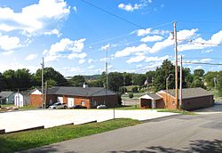
There is one government building in the city which functions as the town's library, courthouse, police station, and fire station. Directly across the road from this building is a baseball field where Little League games are held.

Calhoun had its own high school that shut down in 1980. They had some very successful baseball teams. They also had basketball teams. Their cross river rivals were the Charleston panthers who also later closed their high school in 2001.

On December 11, 1990, a heavy fog led to a crash involving 99 vehicles along Interstate 75 near Calhoun, killing 12 and injuring 42. As a result, electronic speed limit signs equipped with fog sensors have been installed along the Calhoun section of the interstate. [12] [13]

Geography

Calhoun is situated along the north bank of the Hiwassee River, which flows from the Appalachian Mountains to the east and empties into the Chickamauga Lake impoundment of the Tennessee River a few miles to the west. The river forms the boundary between McMinn County and Bradley County. The town of Charleston is located across the river to the south, on the Bradley County side.

Calhoun is situated around the junction of U.S. Route 11, which connects the town to Athens to the north and Charleston and Cleveland to the south, and State Route 163 (Bowater Road), which connects Calhoun to U.S. Route 411 in Delano to the east and Interstate 75 (Exit 36) to the west.

According to the United States Census Bureau, the town has a total area of 1.1 square miles (2.8 km2), of which 1.0 square mile (2.6 km2) is land and 0.1 square miles (0.26 km2) (4.67%) is water.

Demographics

Historical population
CensusPop.Note
1870 232
1880 203−12.5%
1890 2229.4%
1970 624
1980 590−5.4%
1990 552−6.4%
2000 496−10.1%
2010 490−1.2%
2020 5369.4%
Sources: [14] [15] [3]

2020 census

Calhoun racial composition [16]
RaceNumberPercentage
White (non-Hispanic)47688.81%
Black or African American (non-Hispanic)122.24%
Other/Mixed 346.34%
Hispanic or Latino 142.61%

As of the 2020 United States census, there were 536 people, 230 households, and 144 families residing in the town.

2000 census

As of the census [4] of 2000, there were 496 people, 205 households, and 148 families residing in the town. The population density was 486.4 inhabitants per square mile (187.8/km2). There were 225 housing units at an average density of 220.6 per square mile (85.2/km2). The racial makeup of the town was 97.78% White, 0.81% African American, 1.01% Asian, and 0.40% from two or more races. Hispanic or Latino of any race were 3.43% of the population.

There were 205 households, out of which 28.3% had children under the age of 18 living with them, 60.0% were married couples living together, 7.8% had a female householder with no husband present, and 27.8% were non-families. 25.9% of all households were made up of individuals, and 10.7% had someone living alone who was 65 years of age or older. The average household size was 2.42 and the average family size was 2.86.

In the town, the population was spread out, with 22.6% under the age of 18, 6.0% from 18 to 24, 25.2% from 25 to 44, 29.2% from 45 to 64, and 16.9% who were 65 years of age or older. The median age was 41 years. For every 100 females, there were 101.6 males. For every 100 females age 18 and over, there were 93.9 males.

The median income for a household in the town was $38,438, and the median income for a family was $44,688. Males had a median income of $36,563 versus $20,333 for females. The per capita income for the town was $19,984. About 5.3% of families and 10.2% of the population were below the poverty line, including 3.5% of those under age 18 and 9.5% of those age 65 or over.


Education

McMinn County Schools operates public schools, including Calhoun Elementary School. [17] Calhoun had its own high school that shut down in 1980

Related Research Articles

<span class="mw-page-title-main">Cherokee County, Alabama</span> County in Alabama, United States

Cherokee County, Alabama is a county located in the northeastern part of the U.S. state of Alabama. As of the 2020 census, the population was 24,971. Its county seat is Centre. The county is named for the Cherokee tribe.

<span class="mw-page-title-main">Polk County, Tennessee</span> County in Tennessee, United States

Polk County is a county located in the southeastern corner of the U.S. state of Tennessee. As of the 2020 United States census, its population was 17,544. Its county seat is Benton. The county was created on November 28, 1839, from parts of Bradley and McMinn counties, after final removal of most Cherokee from the region that year. The county was named after then-governor James K. Polk. Polk County is included in the Cleveland, Tennessee Metropolitan Area Statistical Area, which is also included in the Chattanooga–Cleveland–Dalton, TN–GA–AL Combined Statistical Area.

<span class="mw-page-title-main">Monroe County, Tennessee</span> County in Tennessee, United States

Monroe County is a county located on the eastern border of the U.S. state of Tennessee. As of the 2020 census, the population was 46,250. Its county seat is Madisonville, and its largest city is Sweetwater.

<span class="mw-page-title-main">Meigs County, Tennessee</span> County in Tennessee, United States

Meigs County is a county located in the U.S. state of Tennessee. As of the 2020 census, the population was 12,758. Its county seat is Decatur.

<span class="mw-page-title-main">McMinn County, Tennessee</span> County in Tennessee, United States

McMinn County is a county in the U.S. state of Tennessee. It is located in East Tennessee. As of the 2020 census, the population was 53,794. The county has a total area of 432 square miles (1,120 km2). Most of the county is within the Ridge and Valley area of the Appalachian Mountains. Its county seat is Athens. McMinn County, along with Meigs County comprises the Athens, TN Micropolitan Statistical Area.

<span class="mw-page-title-main">Loudon County, Tennessee</span> County in Tennessee, United States

Loudon County is a county in the U.S. state of Tennessee. It is located in the central part of East Tennessee. As of the 2020 census, the population was 54,886. Its county seat is Loudon. Loudon County is included in the Knoxville, TN Metropolitan Statistical Area.

<span class="mw-page-title-main">Bradley County, Tennessee</span> County in Tennessee, United States

Bradley County is a county located in the southeastern portion of the U.S. state of Tennessee. As of the 2020 census, the population was 108,620, making it the thirteenth most populous county in Tennessee. Its county seat is Cleveland. It is named for Colonel Edward Bradley of Shelby County, Tennessee, who was colonel of Hale's Regiment in the American Revolution and the 15th Regiment of the Tennessee Volunteers in the War of 1812. Bradley County is included in the Cleveland, Tennessee Metropolitan Statistical Area, which is also included in the Chattanooga-Cleveland-Dalton, TN-GA-AL Combined Statistical Area.

<span class="mw-page-title-main">Cherokee County, North Carolina</span> County in North Carolina, United States

Cherokee County is the westernmost county in the U.S. state of North Carolina. It borders Tennessee to its west and Georgia to its south. As of the 2020 census, the population was 28,774. The county seat is Murphy.

<span class="mw-page-title-main">Walker County, Georgia</span> County in Georgia, United States

Walker County is a county located in the northwestern part of the U.S. state of Georgia. As of the 2020 census, the population was 67,654, down from 68,756 in 2010. The county seat is LaFayette. The county was created on December 18, 1833, from land formerly belonging to the Cherokee Indian Nation.

<span class="mw-page-title-main">Gordon County, Georgia</span> County in Georgia, United States

Gordon County is a county located in the northwestern part of the U.S. state of Georgia. As of the 2020 census, the population was 57,544. The county seat is Calhoun. Gordon County comprises the Calhoun, GA Micropolitan Statistical Area, which is included in the Chattanooga-Cleveland-Dalton Combined Statistical Area.

<span class="mw-page-title-main">Fannin County, Georgia</span> County in Georgia, United States

Fannin County is a county located in the north central portion of the U.S. state of Georgia. As of the 2020 census, the population was 25,319. It is one of the most rural counties in Georgia due its location in the Appalachian Mountain Range, with about 90% of the population of Fannin County living in unincorporated lands. The county seat and largest city is Blue Ridge. The county was created on January 21, 1854, and is named after James Fannin, a veteran who fought in the Texas Revolution.

<span class="mw-page-title-main">Catoosa County, Georgia</span> County in Georgia, United States

Catoosa County is a county located in the northwestern part of the U.S. state of Georgia. As of the 2020 census, the population was 67,872. The county seat is Ringgold. The county was created on December 5, 1853. The meaning of the Cherokee language name "Catoosa" is obscure: "Catoosa" may come from the Cherokee words gatusi or gatu'gitse.

<span class="mw-page-title-main">Hiawassee, Georgia</span> City in Georgia, United States

Hiawassee is the county seat of Towns County, Georgia, United States. The community's population was 880 at the 2010 census. Its name is derived from the Cherokee—or perhaps Creek—word Ayuhwasi, which means meadow, Hiawassee is also known in the novel "Restart" by Gordon Korman.

<span class="mw-page-title-main">Pendleton, South Carolina</span> Town in South Carolina, United States

Pendleton is a town in Anderson County, South Carolina, United States. The population was 3,489 at the 2020 census. It is a sister city of Stornoway in the Outer Hebrides of Scotland.

<span class="mw-page-title-main">Charleston, Tennessee</span> City in Tennessee, United States

Charleston is a city in Bradley County, Tennessee, United States. The population was 664 at the 2020 census. It is included in the Cleveland Metropolitan Statistical Area.

<span class="mw-page-title-main">Athens, Tennessee</span> City in Tennessee, United States

Athens is the county seat of McMinn County, Tennessee, United States and the principal city of the Athens Micropolitan Statistical Area has a population of 53,569. The city is located almost equidistantly between the major cities of Knoxville and Chattanooga. The population was 14,084 at the 2020 census. The population of the zipcode area is at 23,726

<span class="mw-page-title-main">Englewood, Tennessee</span> Town in Tennessee, United States

Englewood is a town in McMinn County, Tennessee, United States. The population was 1,550 in 2020.

<span class="mw-page-title-main">Madisonville, Tennessee</span> City in Tennessee, United States

Madisonville is the county seat of Monroe County, Tennessee, United States. It is located in East Tennessee on the eastern border of the state. As of the 2020 census, the city's population was 5,132.

<span class="mw-page-title-main">Benton, Tennessee</span> Town in Tennessee, United States

Benton is a town in Polk County, Tennessee, United States. The population was 1,532 at the 2020 census. It is the county seat.

<span class="mw-page-title-main">Hiwassee River</span> River in Georgia, North Carolina and Tennessee

The Hiwassee River originates from a spring on the north slope of Rocky Mountain in Towns County in the northern area of the State of Georgia. It flows northward into North Carolina before turning westward into Tennessee, flowing into the Tennessee River a few miles west of what is now State Route 58 in Meigs County, Tennessee. The river is about 147 miles (237 km) long.

References

  1. Tennessee Blue Book , 2005-2006, pp. 618-625.
  2. "ArcGIS REST Services Directory". United States Census Bureau. Retrieved October 15, 2022.
  3. 1 2 "Census Population API". United States Census Bureau. Retrieved October 15, 2022.
  4. 1 2 "U.S. Census website". United States Census Bureau . Retrieved January 31, 2008.
  5. "US Board on Geographic Names". United States Geological Survey. October 25, 2007. Retrieved January 31, 2008.
  6. Tennessee Department of Economic and Community Development, Certified Population of Tennessee Incorporated Municipalities and Counties Archived June 30, 2014, at the Wayback Machine , State of Tennessee official website, July 14, 2011. Retrieved: December 6, 2013.
  7. Lillard, Roy G. (June 8, 1986). "Charleston is One of Oldest Places in Southeast Tennessee". Cleveland Daily Banner.
  8. C. Stephen Byrum, McMinn County (Memphis, Tenn.: Memphis State University Press, 1984), 9-20.
  9. "Goodspeed's History of McMinn County, Tennessee," 1887. Transcribed for web content by Harold Mitchell. Retrieved: December 31, 2007.
  10. Denton, Colby (May 5, 2019). "Calhoun celebrates 200th year". Cleveland Daily Banner. Retrieved November 2, 2020.
  11. "Bowater Calhoun, Tennessee Operations," 2007. Retrieved: December 31, 2007.
  12. The National Transportation Safety Board, "Highway Accident Report HAR-92/02." Adopted: September 28, 1992. Retrieved: December 31, 2007.
  13. Matthew Wald, "War on Road Fog Lacks Easy Solution." The New York Times, June 18, 2003. Retrieved: December 31, 2007.
  14. "Census of Population and Housing: Decennial Censuses". United States Census Bureau . Retrieved March 4, 2012.
  15. "Incorporated Places and Minor Civil Divisions Datasets: Subcounty Resident Population Estimates: April 1, 2010 to July 1, 2012". Population Estimates. U.S. Census Bureau. Archived from the original on June 11, 2013. Retrieved December 11, 2013.
  16. "Explore Census Data". data.census.gov. Retrieved December 27, 2021.
  17. "Home". Calhoun Elementary School. Retrieved January 28, 2022.

35°17′45″N84°44′53″W / 35.295712°N 84.748027°W / 35.295712; -84.748027