
Roxbury is a neighborhood within the City of Boston, Massachusetts, United States.
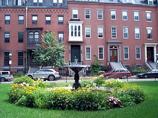
The South End is a neighborhood in Boston, Massachusetts, United States which is bordered by Back Bay, Chinatown, and Roxbury. It is distinguished from other neighborhoods by its Victorian-style houses and the parks in and around the area. The South End is the largest intact Victorian row-house district in the country, covering over 300 acres (120 ha). It has eleven residential parks. In 1973, the South End was listed on the National Register of Historic Places. Much of the neighborhood was originally marshlands in Boston's South Bay. After it was filled in, construction began on January 7, 1849.
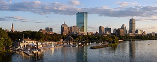
Back Bay is an officially recognized neighborhood of Boston, Massachusetts, built on reclaimed land in the Charles River basin. Construction began in 1859, as the demand for luxury housing exceeded the availability in the city at the time, and the area was fully built by around 1900. It is most famous for its rows of Victorian brownstone homes—considered one of the best preserved examples of 19th-century urban design in the United States—as well as numerous architecturally significant individual buildings, and cultural institutions such as the Boston Public Library, and Boston Architectural College. Initially conceived as a residential-only area, commercial buildings were permitted from around 1890, and Back Bay now features many office buildings, including the John Hancock Tower, Boston's tallest skyscraper. It is also considered a fashionable shopping destination and home to several major hotels.

Beacon Hill is a historic neighborhood in Boston, Massachusetts, United States. It is also the location of the Massachusetts State House. The term "Beacon Hill" is used locally as a metonym to refer to the state government or the legislature itself, much like Washington, D.C.'s Capitol Hill does at the federal level.

The Danvers State Hospital, also known as the State Lunatic Hospital at Danvers, The Danvers Lunatic Asylum, and The Danvers State Insane Asylum, was a psychiatric hospital located in Danvers, Massachusetts. It was built in 1874, and opened in 1878, under the supervision of prominent Boston architect Nathaniel Jeremiah Bradlee, on an isolated site in rural Massachusetts. It was a multi-acre, self-contained psychiatric hospital designed and built according to the Kirkbride Plan.

John Frederick Collins was an American lawyer who served as the mayor of Boston from 1960 to 1968. Collins was a lawyer who served in the Massachusetts Legislature from 1947 to 1955. He and his children caught polio during a 1955 outbreak. He was reliant on a wheelchair and crutches the rest of his life. After partially recovering, he ran for mayor in 1959 as an underdog. He successfully portrayed himself as outside corrupt "machine politics" and was elected.

Mission Hill is a 3⁄4 square mile, primarily residential neighborhood of Boston, bordered by Roxbury, Jamaica Plain and Fenway-Kenmore and the town of Brookline. The neighborhood has two main streets, namely Tremont Street and Huntington Avenue. It is served by several stations on the MBTA's Green Line E branch, as well as Roxbury Crossing station on the Orange Line.
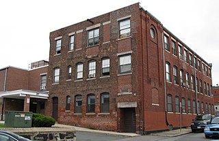
The Berger Factory is a historic factory building at 37 Williams Street in Boston, Massachusetts. Built in 1902, it was home to one of the nation's first manufacturers of precision engineering and surveying instruments, and a surviving example of Roxbury's late 19th-century industrial development. It was listed on the National Register of Historic Places in 1980, and now houses residences.

The Sarah J. Baker School is an historic school building in Boston, Massachusetts. Built in 1905 by a prominent local architect, it is a well-preserved example of early 20th-century Romanesque Revival school architecture. The building was listed on the National Register of Historic Places in 1983, and was included in the Moreland Street Historic District in 1984. It has been converted to elderly housing.

The Lower Roxbury Historic District is a historic district encompassing an isolated pocket of 1890s mixed residential-commercial property in the lower Roxbury neighborhood of Boston, Massachusetts. Bounded by Tremont, Columbus, and Burke Streets and St. Cyprian's Place, the area contains a well-kept collection of architect designed buildings that survived late 20th-century urban redevelopment. The district was added to the National Register of Historic Places in 1994.

Mount Pleasant Historic District is a historic district encompassing a cluster of well-preserved 19th-century residential buildings on Forest Street and Mount Pleasant Avenue in the Roxbury neighborhood of Boston, Massachusetts. First developed in 1833, it was one Roxbury's first speculative residential subdivision developments. The district features Greek Revival, Italianate, and Romanesque architecture, and was added to the National Register of Historic Places in 1989.

The Sumner Hill Historic District encompasses a predominantly residential area of high-quality late 19th-century residences in the Jamaica Plain neighborhood of Boston, Massachusetts. It is roughly bounded by Seaverns Avenue, Everett Street, Carolina Avenue, and Newbern Street just east of the neighborhoods commercial Centre Street area. The district features Second Empire, Italianate, and Queen Anne style architecture, and was listed on the National Register of Historic Places in 1987.
The Boston Housing Authority (BHA) is a public agency within the city of Boston, Massachusetts that provides subsidized public housing to low- and moderate-income families and individuals. The BHA is not a municipal agency, but a separate local entity.

The Sarah Davidson Apartment Block is a historic commercial and multifamily residential building at 3 Gaylord Street in the Dorchester neighborhood of Boston, Massachusetts. The three-story brick, sandstone and copper Classical Revival building was constructed in 1901 to a design by A. B. Pinkham. The building, located at the corner of Gaylord and Washington Streets, has three commercial storefronts facing Washington Street, which are separated by sandstone piers. The residential entrance lies on Gaylord Street recessed in a rounded sandstone archway. The exterior of the upper floors consists of protruding sections finished in pressed copper, including a rounded corner section, and sections of brick. A heavy denticulated copper cornice overhangs both street-facing facades.

Fort Hill is a 0.4 square mile neighborhood and historic district of Roxbury, in Boston, Massachusetts. The approximate boundaries of Fort Hill are Malcolm X Boulevard on the north, Washington Street on the southeast, and Columbus Avenue on the southwest.

The Governor Shirley Square Historic District encompasses a cluster of civic, residential, and religious buildings at the junction of Dudley, Hampden, and Dunmore Streets in the Roxbury neighborhood of Boston, Massachusetts. Named for colonial governor William Shirley in 1913, the square was developed in the 1870s and 1880s as a major locus of civic development after the city of Roxbury was annexed to Boston in 1868. The district was listed on the National Register of Historic Places in 2016.
The Ascension-Caproni Historic District encompasses a mixed collection of late 19th and early 20th century architecture along Washington, Newcomb, and Thorndike Streets in the Roxbury neighborhood of Boston, Massachusetts. Including religious, residential, commercial, and industrial buildings, it encapsulates the area's transition from industrial to residential uses between about 1850 and 1930. The district was listed on the National Register of Historic Places in 2019.

The Lawrence Avenue Historic District is a historic district encompassing a small residential area in the Dorchester neighborhood of Boston, Massachusetts. Centered on Lawrence Avenue, the area was developed in the late 19th and early 20th century during a major Jewish migration, and includes a fine sample of Colonial Revival and Queen Anne architecture. The district was listed on the National Register of Historic Places in 2021.

The Greenville Street Historic District is a historic district encompassing a primarily residential property in the Roxbury neighborhood of Boston, Massachusetts. Extending along Greenville Street, the district includes a diversity of architecture, and is prominent for significant urban renewal efforts conducted in the city in the 1960s and 1970s. The district was added to the National Register of Historic Places in 2021.

The Walnut Park Historic District is a historic district encompassing a cluster of multifamily brick buildings in the Roxbury neighborhood of Boston, Massachusetts. Roughly centered on the junction of Walnut Park and Waldren Road, the area was developed in the early 20th century during a major Jewish migration, and includes a fine sample of Colonial Revival architecture. The district was listed on the National Register of Historic Places in 2022.


