
Cripple Creek is a statutory city that is the county seat of Teller County, Colorado, United States. The city population was 1,155 at the 2020 United States Census. Cripple Creek is a former gold mining camp located 20 miles (32 km) southwest of Colorado Springs near the base of Pikes Peak. The Cripple Creek Historic District, which received National Historic Landmark status in 1961, includes part or all of the city and the surrounding area. The city is now a part of the Colorado Springs, CO Metropolitan Statistical Area and the Front Range Urban Corridor.

Lillooet is a district municipality in the Squamish-Lillooet region of southwestern British Columbia. The town is on the west shore of the Fraser River immediately north of the Seton River mouth. On BC Highway 99, the locality is by road about 100 kilometres (62 mi) northeast of Pemberton, 64 kilometres (40 mi) northwest of Lytton, and 172 kilometres (107 mi) west of Kamloops.

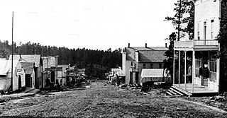
Rhyolite is a ghost town in Nye County, in the U.S. state of Nevada. It is in the Bullfrog Hills, about 120 miles (190 km) northwest of Las Vegas, near the eastern boundary of Death Valley National Park.
British Columbia gold rushes were important episodes in the history and settlement of European, Canadian and Chinese peoples in western Canada.

The Fraser Canyon Gold Rush, began in 1858 after gold was discovered on the Thompson River in British Columbia at its confluence with the Nicoamen River a few miles upstream from the Thompson's confluence with the Fraser River at present-day Lytton. The rush overtook the region around the discovery and was centered on the Fraser Canyon from around Hope and Yale to Pavilion and Fountain, just north of Lillooet.

Baldy Mountain, Baldy Peak, Mount Baldy, or Old Baldy is the highest peak in the Cimarron Range, a subrange of the Sangre de Cristo Mountains of New Mexico. It is located in Colfax County, about 6 miles (10 km) northeast of Eagle Nest. It rises abruptly, with 3,640 feet (1,110 m) of vertical relief, from the Moreno Valley to the west and has a total elevation of 12,441 feet (3,792 m).

Delamar, Nevada, nicknamed The Widowmaker, is a ghost town in central eastern Nevada, USA along the east side of the Delamar Valley. During its heyday, primarily between 1895 and 1900, it produced $13.5 million in gold.

Greenwood is a city in south central British Columbia. It was incorporated in 1897 and was formerly one of the principal cities of the Boundary Country smelting and mining district. It was incorporated as a city originally and has retained that title despite the population decline following the closure of the area's industries.
The Boundary Country is a historical designation for a district in southern British Columbia lying, as its name suggests, along the boundary between Canada and the United States. It lies to the east of the southern Okanagan Valley and to the west of the West Kootenay. It is often included in descriptions of both of those regions but historically has been considered a separate region. Originally inclusive of the South Okanagan towns of Osoyoos and Oliver, today the term continues in use to refer to the valleys of the Kettle, West Kettle, and Granby Rivers and of Boundary and Rock Creeks and that of Christina Lake and of their various tributaries, all draining the south slope of the Monashee Mountains. The term Boundary District as well as the term Boundary Country can both refer to the local mining division of the British Columbia Ministry of Mines, Energy and Petroleum Resources.

Phoenix is a ghost town in the Boundary Country of British Columbia, Canada, 11 km east of Greenwood. Once called the "highest city in Canada" by its citizens it was a booming copper mining community from the late 1890s until 1919. In its heyday it was home to 1,000 citizens and had an opera house, twenty hotels, a brewery and its own city hall. Phoenix's magistrate, Judge Willie Williams, who served there from 1897 until 1913, became famous for his booming declaration, "I am the highest judge, in the highest court, in the highest city in Canada." In 1911, Phoenix's hockey team won the provincial championship and asked for the right to compete for the Stanley Cup, but it was too late to qualify. The Granby Consolidated Mining, Smelting and Power Company operated the Phoenix Mine, a copper mine that produced 13,678,901 tons of ore before operations ceased on June 14, 1919.

Rock Creek is a settlement in the Boundary Country region of south central British Columbia. The unincorporated settlement is mostly on the southwest side of the Kettle River at the confluence with Rock Creek. The place lies at the junction of BC Highway 33, and BC Highway 3.

Williams Creek is an important historical gold mining creek in the Cariboo goldfields of the Central Interior of British Columbia, entering the Willow River between Barkerville and the town of Wells, which is at the headwaters of the Willow River.
Granby Consolidated Mining, Smelting and Power Co. was established by charter to operate in the Boundary region of southern British Columbia. Primarily involved in the mining and smelting of copper, the conglomerate became a publicly traded company. The various corporate operating names within the former group mostly specified the Granby identity.
Mulwarrie is an abandoned town in the North Coolgardie Goldfield of the Goldfields-Esperance region of Western Australia, 125 km northwest of Kalgoorlie, between Davyhurst and Mulline.
Gold Trails and Ghost Towns is a Canadian historical documentary show, created and produced by television station CHBC-TV in Kelowna, British Columbia for Canadian syndication and hosted by Mike Roberts with historian/storyteller Bill Barlee. The show was filmed in a studio which resembled an old trapper's cabin. Mike and Bill discussed prospectors and the history of British Columbia around 1900.
Carbonate, also known as Carbonate Camp, West Virginia, Virginia, and Carbonate City (1881-1939), is a ghost town located in Lawrence County, South Dakota, United States.
The Cripple Creek Gold Rush was a period of gold production in the Cripple Creek area from the late 1800s until the early 1900s. Mining exchanges were in Cripple Creek, Colorado Springs, Pueblo and Victor. Smelting was in Gillett, Florence, and (Old) Colorado City. Mining communities sprang up quickly, but most lasted only as long as gold continued to be produced. Settlements included:

Cortez is a ghost town in Lander County, in the U.S. state of Nevada. The GNIS classifies it as a populated place.
Johntown is a ghost town in Lyon County, Nevada United States. It was originally an important mining camp in Gold Canyon, midway between Dayton, Nevada and Silver City. In the late 1850s, Johntown was the largest mining camp in the western Utah Territory.

Baldy Town, New Mexico is a former mining town in the Baldy Mining District in Colfax County, New Mexico. Baldy Town was established in 1868, to service mining prospects on the East side of Baldy Mountain, notably the Aztec Mine. After Baldy Town's initial high profit boom from 1868-1870, Baldy Town suffered a series of booms and busts as investors and prospectors searched for profitable lodes. The town was originally a conglomerate of miner's homes and services in Ute Meadow. Then in 1886, Baldy Town's core was moved to a strip of services just above the Aztec Mill. The new town grew to accommodate hundreds of residents with a store, stables, saloons, boarding houses, a church, small school, and post office. In 1895, at the height of its population, Baldy Town was home to around 1,000 residents. Multiple ambitious and extensive expeditions were made from 1870-1936 to discover additional gold veins, but only a select few found substantial lodes. By 1941, Baldy Town had been deserted and a majority of its infrastructure sold. In 1963, the eastern half of Baldy Mountain, including former Baldy Town, was donated to the Boy Scouts of America by Norton Clapp. Today, Baldy Town operates as a staffed camp at Philmont Scout Ranch providing a living history program regarding mining as well as logistical support like food resupply for hikers
