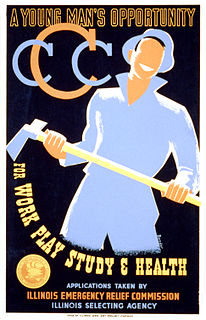
The Civilian Conservation Corps (CCC) was a voluntary government work relief program that ran from 1933 to 1942 in the United States for unemployed, unmarried men ages 18–25 and eventually expanded to ages 17–28. Robert Fechner was the first director of this agency, succeeded by James McEntee following Fechner's death. The CCC was a major part of President Franklin D. Roosevelt's New Deal that supplied manual labor jobs related to the conservation and development of natural resources in rural lands owned by federal, state, and local governments. The CCC was designed to supply jobs for young men and to relieve families who had difficulty finding jobs during the Great Depression in the United States. The largest enrollment at any one time was 300,000. Through the course of its nine years in operation, three million young men took part in the CCC, which provided them with shelter, clothing, and food, together with a wage of $30 per month.

The Presidio of San Francisco is a park and former U.S. Army post on the northern tip of the San Francisco Peninsula in San Francisco, California, and is part of the Golden Gate National Recreation Area.

Marine Corps Base Camp Pendleton is the major West Coast base of the United States Marine Corps and is one of the largest Marine Corps bases in the US. It is on the Southern California coast in San Diego County and is bordered by Oceanside to the south, San Clemente and Orange County to the north, Riverside County to the northeast, and Fallbrook to the east.

Cuesta College is a public community college in San Luis Obispo County, California.
Fort Hunter Liggett is a United States Army fort in Jolon, California, in southern Monterey County, California. The fort, named in 1941 after General Hunter Liggett, is primarily used as a training facility, where activities such as field maneuvers and live fire exercises are performed. It is roughly 25 miles northwest of Camp Roberts, California.

The California Military Academy is a military academy of the California Army National Guard located at Camp San Luis Obispo.
The California Army National Guard is one of three components of the California National Guard, a reserve of the United States Army, and part of the National Guard of the United States. The California Army National Guard is composed of 18,450 soldiers. Nationwide, the Army National Guard comprises approximately one half of the US Army's available combat forces and approximately one third of its support organization. National coordination of various state National Guard units are maintained through the National Guard Bureau.

Camp Kearny was a U.S. military base in San Diego County, California, on the site of the current Marine Corps Air Station Miramar. It operated from 1917 to 1946. The base was named in honor of Brigadier General Stephen W. Kearny.
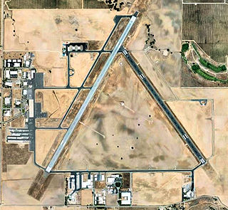
Paso Robles Municipal Airport is four miles (6 km) northeast of downtown Paso Robles, in San Luis Obispo County, California, United States.

Camp Bullis Military Training Reservation is a U.S. Army training camp comprising 27,990 acres (113.3 km2) in Bexar County, Texas, USA, just northwest of San Antonio. Camp Bullis provides Base Operations Support and Training Support to Joint Base San Antonio. The camp is named for Brigadier General John L. Bullis.

Camp Roberts is a California National Guard post in central California, located on both sides of the Salinas River in Monterey and San Luis Obispo counties, now run by the California Army National Guard. It was opened in 1941 and is named after Corporal Harold W. Roberts, a World War I Medal of Honor recipient. Nearby communities include San Miguel, Heritage Ranch, Oak Shores, and Bradley, all unincorporated. The nearest incorporated city is Paso Robles. Camp Roberts is roughly 25 miles southeast of Fort Hunter Liggett.

Camp Tulelake was a federal work facility and War Relocation Authority isolation center located in Siskiyou County, five miles west of Tulelake, California. It was established by the United States government in 1935 during the Great Depression for vocational training and work relief for young men, in a program known as the Civilian Conservation Corps. The camp was established initially for CCC enrollees to work on the Klamath Reclamation Project.

The Land Conservancy of San Luis Obispo County (LCSLO) is a local nonprofit organization in California that has served San Luis Obispo (SLO) County since 1984. Through voluntary and collaborative efforts the LCSLO works to protect and enhance lands having important scenic, agricultural, habitat and cultural values for the benefit of people and wildlife.
Rancho San Luisito was a 4,389-acre (17.76 km2) Mexican land grant in present day San Luis Obispo County, California given in 1841 by Governor Juan B. Alvarado to José de Guadalupe Cantúa. The grant between Morro Bay and San Luis Obispo, extended along San Luisito Creek and Chorro Creek and encompassed Hollister Peak.
Camp McQuaide is a former United States Army camp located near the city of Watsonville in Santa Cruz County, California, USA. After it was closed, it redeveloped into the Monterey Bay Academy and the airfield was reopened as the Monterey Bay Academy Airport.

Camp Kohler was located in the northeast corner of unincorporated Sacramento County, California, United States, until it was destroyed by a fire in 1947. Initially a camp for migrant farm workers, it became the Sacramento Assembly Center a temporary detention center for interned Japanese Americans in 1942. The site is one of 12 California assembly centers that share designation as California Historical Landmark No. 934. From 1943 to 1945 the camp was a training center for US World War II forces.

The Salinas Dam is a dam built on the Salinas River in San Luis Obispo County, California. Designed by Raymond A. Hill, the gravity dam features an arched design with an open spillway. The War Department began construction on the dam in mid-1941, as World War II began to reach the Pacific. The original intent of the dam was to supply water to Camp San Luis Obispo, which the Army was considering expanding to meet military needs. However, the camp’s wells ultimately provided sufficient water to the camp, and the reservoir water was never required or used by the military. Today, the dam operations are leased by the city of San Luis Obispo, to supply water to the city and surrounding agricultural areas. The reservoir created by the dam is known as the Santa Margarita Lake, or Santa Margarita Reservoir.

California during World War II was a major contributor to the World War II effort. California's long Pacific Ocean coastline provided the support needed for the Pacific War. California also supported the war in Europe. After the Japanese attack on Pearl Harbor, Hawaii, on December 7, 1941, most of California's manufacturing was shifted to the war effort. California became a major ship builder and aircraft manufacturer. Existing military installations were enlarged and many new ones were built. California trained many of the troops before their oversea deployment. Over 800,000 Californians served in the United States Armed Forces. California agriculture, ranches and farms were used to feed the troops around the world. California's long coastline also put the state in fear, as an attack on California seemed likely. California was used for the temporary and permanent internment camps for Japanese Americans. The population of California grew significantly, largely due to servicemen who were stationed at the new military bases/training facilities and mass influx of workers from around the U.S. in the growing defense industries. With all the new economy activity, California was lifted out of the great depression. Over 500,000 people moved to California from other states to work in the growing economy. California expanded its oil and mineral production to keep up with the war demand.

Amphibious Training Base Morro Bay also called Camp Morro Bay and Morro Bay Section Base was a US Navy training base for amphibious beach assault during World War II. The base opened in 1941 to train troops for the Pacific theater of operations' island leapfrogging using landing craft and LCVP. The base was located in Morro Bay, California in San Luis Obispo County. The base was on 250 acres (100 ha) of leased land. Ships for the base were based at the Avila's Port San Luis in San Luis Bay. Which was also leased with the yacht club and its warehouse. Added to the leased land was: two piers, mess hall, gallon water storage tanks, roads, buildings, garages, and ammo storage area. The Navy also extended the bay's breakwater. A wooden trestle bridge was built to get to the nearby sandspit, the bridge was removed in 1946 and some pillars still remain. The near Estero Bay was the site of training assault also, by the Navy, US Army, US Marine Corps and United States Coast Guard also taking over the unused vacation hotel there. Nearby United States Army Air Corps fields had fighter aircraft fire flour shot to make the training more real. Up to 175 landing craft were at the base and 16,000 troops a day trained. In the base and in nearby Los Osos and Baywood live fire bombing, machine gun, bazookas, and flamethrowers were used for training. The training ended on 31 October 1945 and the site is now a Duke Energy power plant built in 1955, site of three large smoke stacks. North of the former base in the notable Morro Rock. Avila Beach was also a Union Oil plant with many oil storage tanks, use for Navy ships.

Borrego Valley Maneuver Area also called the Borrego Springs Naval Maneuver Area was a US Army Anti-Aircraft Training Center (AARTC) and a subcamp of Camp Callan. Located near Borrego Springs, California in San Diego County in the Imperial Valley. Opened in March 1942 and in use until August 1944, it was operated by the Western Defense Command. Marine Corps also used the site to train troops in driving army vehicles. The site was picked as it was 400 square miles, 255,840 acres, of barren desert, barren mountains, and badlands. When closed the land returned to the State of California. Built at the site were bombing stations, strafing stations, and rocket targets. Also installed was Anti-Aircraft Artillery for training. First week troop did dry run training and the second week live-fire training. Ammo fired was from .33 to 90mmm. The US Navy trained in the bombing, gunnery, and rocketry. California Institute of Technology help with the rocket training. The air support the base was Naval Outlying Landing Field Clark's Dry Lake, Naval Outlying Field, Ocotillo Dry Lake and Borrego Hotel Naval Outlying Landing Field.


