Nellis Air Force Base is a United States Air Force installation in southern Nevada. Nellis hosts air combat exercises such as Exercise Red Flag and close air support exercises such as Green Flag-West flown in "Military Operations Area (MOA) airspace", associated with the nearby Nevada Test and Training Range (NTTR). The base also has the Combined Air and Space Operations Center-Nellis.

The Northrop GrummanEA-6B Prowler is a twin-engine, four-seat, mid-wing electronic-warfare aircraft derived from the A-6 Intruder airframe. The EA-6A was the initial electronic warfare version of the A-6 used by the United States Marine Corps and United States Navy; it was used during the Vietnam War. Development on the more advanced EA-6B began in 1966. An EA-6B aircrew consisted of one pilot and three Electronic Countermeasures Officers, though it was not uncommon for only two ECMOs to be used on missions. It was capable of carrying and firing anti-radiation missiles (ARMs), such as the AGM-88 HARM.

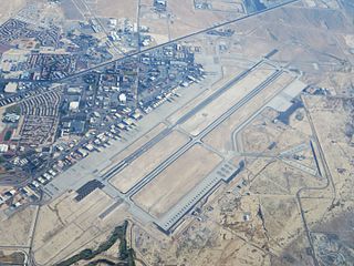
Marine Corps Air Station Yuma or MCAS Yuma is a United States Marine Corps air station in Arizona. It is the home of multiple squadrons of F-35B Lightning IIs of the 3rd Marine Aircraft Wing, Marine Aviation Weapons and Tactics Squadron 1 (MAWTS-1), Marine Operational Test and Evaluation Squadron 1 (VMX-1) and Marine Fighter Training Squadron 401 (VMFT-401), an air combat adversary squadron of the 4th Marine Aircraft Wing of the Marine Corps Reserve. It is a designated Superfund site due to a number of soil and groundwater contaminants, including asbestos.

The Grumman A-6 Intruder is an American twinjet all-weather attack aircraft developed and manufactured by American aircraft company Grumman Aerospace and formerly operated by the U.S. Navy and U.S. Marine Corps.

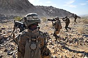
In military tactics, close air support (CAS) is defined as aerial warfare actions—often air-to-ground actions such as strafes or airstrikes—by military aircraft against hostile targets in close proximity to friendly forces. A form of fire support, CAS requires detailed integration of each air mission with fire and movement of all forces involved. CAS may be conducted using aerial bombs, glide bombs, missiles, rockets, autocannons, machine guns, and even directed-energy weapons such as lasers.
The United States Navy Strike Fighter Tactics Instructor program, more popularly known as Top Gun, is a United States Navy training program that teaches air combat maneuvering tactics and techniques to selected naval aviators and naval flight officers, who return to their operating units as surrogate instructors.

Pacific Missile Test Center (PMTC) is the former name of the current Naval Air Warfare Center, Weapons Division. The name of the center was the Naval Air Missile Test Center prior to PMTC. It is located at Naval Base Ventura County/Naval Air Station Point Mugu in Ventura County, California. The nearest city to the installation is Oxnard.

The Naval Aviation Warfighting Development Center was formerly known as the Naval Strike and Air Warfare Center at Naval Air Station Fallon located in the city of Fallon in western Nevada. It is the center of excellence for naval aviation training and tactics development. NAWDC provides service to aircrews, squadrons and air wings throughout the United States Navy through flight training, academic instructional classes, and direct operational and intelligence support. The name was changed from NSAWC to NAWDC in June 2015 to align with the naming convention of the Navy's other Warfighting Development Centers (including Naval Surface and Mine Warfighting Development Center, Naval Information Warfighting Development Center, and the Undersea Warfighting Development Center.

Marine Fighter Attack Squadron 542 (VMFA-542) is a United States Marine Corps Aviation fighter attack squadron flying the F-35B Lightning II. VMFA-542 is based at Marine Corps Air Station Cherry Point, North Carolina and falls under the command of Marine Aircraft Group 14 (MAG-14) and the 2nd Marine Aircraft Wing.
148 (Meiktila) Commando Forward Observation Battery is a specialist Naval Gunfire Support Forward Observation (NGSFO) unit within 29 Commando Regiment Royal Artillery of UK Commando Force Royal Marines.
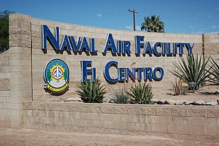
Naval Air Facility El Centro or NAF El Centro is a United States Navy Naval Air Facility located approximately six miles (10 km) northwest of El Centro, in Imperial County, California. NAF El Centro is under the jurisdiction of Navy Region Southwest and serves both as temporary homeport to military units conducting air-to-air and bombing training, and as the winter training home of the Blue Angels aerobatics display team.

Marine Air Control Squadron 1 (MACS-1) is a United States Marine Corps aviation command and control squadron. The squadron provides aerial surveillance, air traffic control, ground-controlled intercept, and aviation data-link connectivity for the I Marine Expeditionary Force. It was the first air warning squadron commissioned as part of the Marine Corps' new air warning program and is the second oldest aviation command and control unit in the Marine Corps. The squadron is based at Marine Corps Air Station Yuma and falls under Marine Air Control Group 38 and the 3rd Marine Aircraft Wing.

Naval Auxiliary Landing Field (NALF) San Clemente Island, also known as Frederick Sherman Field, is a military airport located on San Clemente Island, in Los Angeles County, California, United States. It has been owned by the United States Navy since 1937.
The Nevada Test and Training Range (NTTR) is one of two military training areas at the Nellis Air Force Base Complex in Nevada and used by the United States Air Force Warfare Center at Nellis Air Force Base. The NTTR land area includes a "simulated Integrated Air Defense System", several individual ranges with 1200 targets, and 4 remote communication sites. The current NTTR area and the range's former areas have been used for aerial gunnery and bombing, for nuclear tests, as a proving ground and flight test area, for aircraft control and warning, and for Blue Flag, Green Flag, and Red Flag exercises.
List of abbreviations, acronyms and initials related to military subjects such as modern armour, artillery, infantry, and weapons, along with their definitions.

The AGM-176 Griffin is a lightweight, precision-guided munition developed by Raytheon. It can be launched from the ground or air as a rocket-powered missile or dropped from the air as a guided bomb. It carries a relatively small warhead, and was designed to be a precision low-collateral damage weapon for irregular warfare. It has been used in combat by the United States military during the War in Afghanistan.

The Operational Test and Evaluation Force (OPTEVFOR) is an independent and objective agency within the United States Navy for the operational testing and evaluation (OT&E) of naval aviation, surface warfare, submarine warfare, C4I, cryptologic, and space systems in support Navy and Department of Defense acquisition programs.
The Fallon Range Training Complex (FRTC) is a United States Navy military area with four separate training ranges [plus] an integrated air defense system consisting of thirty-seven real or simulated radars throughout the Dixie Valley area of Nevada. The entire FRTC is also instrumented with a Tactical Aircrew Combat Training System (TACTS).

Lovelock Aerial Gunnery Range was a World War II facility in two Nevada areas used for "aerial gunnery, strafing, dive bombing [and] rocket fire". By 21 November 1944, the Lovelock Range had been approved by the Secretary of the Navy to be developed for Naval Air Station Fallon, and on 13 January 1945, "Lovelock Air to Air" began when "leased under the Second War Powers Act". By February 1945, land was being acquired for the North Range in the Black Rock Desert which was 1,122 sq mi (2,910 km2) that included 64.4 sq mi (167 km2) of "Patented" land. The South Range in the Granite Springs Valley was 2,436 sq mi (6,310 km2), and in March 1945 "1920 Acres more" were added.

Borrego Valley Maneuver Area also called the Borrego Springs Naval Maneuver Area was a US Army Anti-Aircraft Training Center (AARTC) and a subcamp of Camp Callan. Located near Borrego Springs, California in San Diego County in the Imperial Valley. Opened in March 1942 and in use until August 1944, it was operated by the Western Defense Command. Marine Corps also used the site to train troops in driving army vehicles. The site was picked as it was 400 square miles, 255,840 acres, of barren desert, barren mountains, and badlands. When closed the land returned to the State of California. Built at the site were bombing stations, strafing stations, and rocket targets. Also installed was Anti-Aircraft Artillery for training. First week troop did dry run training and the second week live-fire training. Ammo fired was from .33cal to 90mm. The US Navy trained in the bombing, gunnery, and rocketry ranges. California Institute of Technology help with the rocket training. The air support for the base was Naval Outlying Landing Field Clark's Dry Lake, Naval Outlying Field, Ocotillo Dry Lake and Borrego Hotel Naval Outlying Landing Field.