Camporotondo di Fiastrone

Last updated
Camporotondo di Fiastrone
Comune
Comune di Camporotondo di Fiastrone
Camporotondo di Fiastrone-Stemma.png
Coat of arms
Italy provincial location map 2015.svg
Red pog.svg
Camporotondo di Fiastrone
Location of Camporotondo di Fiastrone in Italy
Coordinates: 43°8′N13°16′E / 43.133°N 13.267°E / 43.133; 13.267
Country Italy
Region Marche
Province Macerata (MC)
Government
  Mayor Giorgio Diletti
Area
  Total 8.83 km2 (3.41 sq mi)
Elevation 335 m (1,099 ft)
Population (28 February 2009 [1] )
  Total 613
  Density 69/km2 (180/sq mi)
Time zone CET (UTC+1)
  Summer (DST) CEST (UTC+2)
Postal code62020
Dialing code 0733

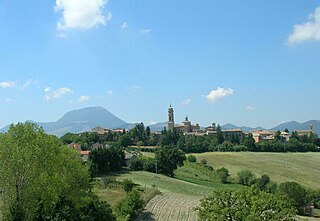
Camporotondo di Fiastrone is a comune (municipality) of about 580 inhabitants in the Province of Macerata in the Italian region Marche, located about 60 kilometres (37 mi) southwest of Ancona and about 25 kilometres (16 mi) southwest of Macerata.

<i>Comune</i> third-level administrative divisions of the Italian Republic

The comune is a basic administrative division in Italy, roughly equivalent to a township or municipality.

Province of Macerata Province of Italy

The province of Macerata is a province in the Marche region of Italy. Its capital is the city of Macerata. The province includes 55 comunes in the province, see Comunes of the Province of Macerata. Located between the rivers Potenza (Flosis) and Chienti, both of which originate in the province, the city of Macerata is located on a hill.

Italy republic in Southern Europe

Italy, officially the Italian Republic, is a country in Southern and Western Europe. Located in the middle of the Mediterranean Sea, Italy shares open land borders with France, Switzerland, Austria, Slovenia and the enclaved microstates San Marino and Vatican City. Italy covers an area of 301,340 km2 (116,350 sq mi) and has a largely temperate seasonal and Mediterranean climate. With around 61 million inhabitants, it is the fourth-most populous EU member state and the most populous country in Southern Europe.

Camporotondo di Fiastrone borders the following municipalities: Belforte del Chienti, Caldarola, Cessapalombo, San Ginesio, Tolentino.

Belforte del Chienti Comune in Marche, Italy

Belforte del Chienti is a comune (municipality) in the province of Macerata in the Italian region Marche, located about 80 kilometres (50 mi) south of Ancona and about 50 kilometres (31 mi) southeast of Macerata.

Caldarola Comune in Marche, Italy

Caldarola is a comune (municipality) in the Province of Macerata in the Italian region Marche, located about 60 kilometres (37 mi) southwest of Ancona and about 25 kilometres (16 mi) southwest of Macerata.

Cessapalombo Comune in Marche, Italy

Cessapalombo is a comune (municipality) in the Province of Macerata in the Italian region Marche, located about 60 kilometres (37 mi) southwest of Ancona and about 25 kilometres (16 mi) southwest of Macerata.

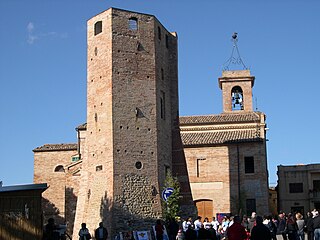
Just east of the town is the Franciscan Convent of Colfano.

The Convento di Colfano of Convento di San Francesco di Colfano is a Franciscan order, Roman Catholic convent and church located in a rural site just off National road 502 outside of the town of Camporotondo di Fiastrone, province of Macerata, region of Marche, Italy.

Related Research Articles

Apiro Comune in Marche, Italy

Apiro is a comune (municipality) in the Province of Macerata in the Italian region Marche, located about 40 kilometres (25 mi) southwest of Ancona and about 25 kilometres (16 mi) northwest of Macerata.

Appignano Comune in Marche, Italy

Appignano is a comune (municipality) in the Province of Macerata in the Italian region Marche, located about 35 kilometres (22 mi) southwest of Ancona and about 20 kilometres (12 mi) northwest of Macerata.

Bolognola Comune in Marche, Italy

Bolognola is a comune (municipality) in the Province of Macerata in the Italian region Marche, located about 70 kilometres (43 mi) southwest of Ancona and about 40 kilometres (25 mi) southwest of Macerata.

Castelraimondo Comune in Marche, Italy

Castelraimondo is a comune (municipality) in the Province of Macerata in the Italian region Marche, located about 60 kilometres (37 mi) southwest of Ancona and about 35 kilometres (22 mi) southwest of Macerata.

Castelsantangelo sul Nera Comune in Marche, Italy

Castelsantangelo sul Nera is a comune (municipality) in the Province of Macerata in the Italian region of Marche, located about 90 kilometres (56 mi) southwest of Ancona and about 50 kilometres (31 mi) southwest of Macerata. The source of the Nera River is located in the communal territory.

Colmurano Comune in Marche, Italy

Colmurano is a comune (municipality) in the Province of Macerata in the Italian region of Marche, located about 50 kilometres (31 mi) southwest of Ancona and about 15 kilometres (9 mi) southwest of Macerata.

Fiastra Comune in Marche, Italy

Fiastra is a comune (municipality) in the Province of Macerata in the Italian region Marche, located about 70 kilometres (43 mi) southwest of Ancona and about 40 kilometres (25 mi) southwest of Macerata.

Gagliole Comune in Marche, Italy

Gagliole is a comune (municipality) in the Province of Macerata in the Italian region Marche, located about 60 kilometres (37 mi) southwest of Ancona and about 30 kilometres (19 mi) west of Macerata.

Monte Cavallo Comune in Marche, Italy

Monte Cavallo is a comune (municipality) in the Province of Macerata in the Italian region Marche, located about 80 kilometres (50 mi) southwest of Ancona and about 45 kilometres (28 mi) southwest of Macerata.

Muccia Comune in Marche, Italy

Muccia is a comune (municipality) in the Province of Macerata in the Italian region Marche, located about 70 kilometres (43 mi) southwest of Ancona and about 40 kilometres (25 mi) southwest of Macerata. As of 31 December 2004, it had a population of 925 and an area of 25.6 square kilometres (9.9 sq mi).

Pieve Torina Comune in Marche, Italy

Pieve Torina is a comune (municipality) in the Province of Macerata in the Italian region Marche, located about 70 kilometres (43 mi) southwest of Ancona and about 45 kilometres (28 mi) southwest of Macerata.

Pollenza Comune in Marche, Italy

Pollenza is a comune (municipality) in the Province of Macerata in the Italian region Marche, located about 40 kilometres (25 mi) southwest of Ancona and about 9 kilometres (6 mi) southwest of Macerata. As of 31 December 2004, it had a population of 6,086 and an area of 39.5 square kilometres (15.3 sq mi).

Ripe San Ginesio Comune in Marche, Italy

Ripe San Ginesio is a comune (municipality) in the Province of Macerata in the Italian region Marche, located about 50 kilometres (31 mi) south of Ancona and about 20 kilometres (12 mi) southwest of Macerata.

San Ginesio Comune in Marche, Italy

San Ginesio is a comune (municipality) in the Province of Macerata in the Italian region Marche, located about 60 kilometres (37 mi) southwest of Ancona and about 25 kilometres (16 mi) southwest of Macerata. As of 31 December 2004, it had a population of 3,872 and an area of 77.7 square kilometres (30.0 sq mi).

Sarnano Comune in Marche, Italy

Sarnano is a comune (municipality) in the Province of Macerata in the Italian region Marche, located about 70 kilometres (43 mi) southwest of Ancona and about 30 kilometres (19 mi) southwest of Macerata.

Sefro Comune in Marche, Italy

Sefro is a comune (municipality) in the Province of Macerata in the Italian region Marche, located about 70 kilometres (43 mi) southwest of Ancona and about 45 kilometres (28 mi) southwest of Macerata. As of 31 December 2004, it had a population of 453 and an area of 42.5 square kilometres (16.4 sq mi).

Serrapetrona Comune in Marche, Italy

Serrapetrona is a comune (municipality) in the province of Macerata in the Italian region Marche, located about 60 kilometres (37 mi) southwest of Ancona and about 25 kilometres (16 mi) southwest of Macerata.

References

  1. All demographics and other statistics: Italian statistical institute Istat.