Campos Novos

Last updated
Campos Novos, SC
CamposNovos CamaraMunicipal.jpg
Bandeiracn.jpg
Brasao CampoNovos SantaCatarina Brasil.jpg
Nickname: 
Granary of Santa Catarina
SantaCatarina Municip CamposNovos.svg
Location of Campos Novos
Brazil location map.svg
Red pog.svg
Campos Novos, SC
Coordinates: 27°24′07″S51°13′30″W / 27.40194°S 51.22500°W / -27.40194; -51.22500
Country Flag of Brazil.svg  Brazil
Region South
State Bandeira de Santa Catarina.svg Santa Catarina
FoundedMarch 30, 1881
Government
  Mayor Vilibaldo Erich Schmid (PMDB)
  Vice MayorJairo Luft (PMDB)
Area
  Total1,659.625 km2 (640.785 sq mi)
Elevation
946.7 m (3,106.0 ft)
Population
 (2020 [1] )
  Total36,556
  Density17.14/km2 (44.4/sq mi)
Time zone UTC-3 (UTC-3)
  Summer (DST) UTC-2 (UTC-2)
HDI (2000)0.794 – high
Website www.camposnovos.sc.gov.br

Campos Novos is a city in Santa Catarina, in the Southern Region of Brazil. Campos Novos is a pioneer in production of pollen and the biggest grain and oat producer of Santa Catarina. The municipality invests also into fat stock and poultry farming.

Contents

Main ethnic origins are Italian, German, Portuguese, Polonese and Drovers.

History

The Kaingang, an Indigenous people of southern Brazil, were the first inhabitants of the region.

The construction of the railway São Paulo - Rio Grande do Sul and the passages of the cattle drovers in the region mobilized many immigrants. Those migrations caused the creation of many villages at the Rio de Peixe river, like Bom Retiro, Capinzal and Videira. The arrival of the Italian and German settlers induced commercial and industrial activities in the 19th and 20th centuries.

Therefore, the city has a rich cultural diversity. It has even a community of descendants of African slaves.

19th century

Casa da Cultura, Campos Novos cultural foundation CamposNovos CasaDaCultura.jpg
Casa da Cultura, Campos Novos cultural foundation

As many of the municipalities in the region, Campos Novos populated from the first attempts of colonialisation in southern Brazil, which began between 1825 and 1830, as the farmer João Gonçalves de Araújo coming from Curitibanos settled down in the region. Shortly afterwards came the gaúchos evading the Ragamuffin War. Many farmers originating from Lages settled down as well, attracted by the huge quantity of terra and grassland. Then, the locality welcomed inhabitants coming from the states São Paulo and Paraná on the search of territory for cattle breeding.

In 1854, Campos Novos became a district of the municipality of Nossa Senhora dos prazeres de Lages, today Lages, with a total area of more than 5 000 km², according to provincial law nº 377, of June 16, 1854. Despite the many partitionings, Campos Novos is still one of the biggest municipality of Santa Catarina regarding the surface area.

From 1869 until 1881, Campos Novos was under control of Curitibanos. Then it became an independent municipality, according to provincial law nº 923, of March 30, 1881. Between 1850 and 1895, the province of Santa Catarina had only 11 municipalities.

20th century

In the beginning of the 20th century, Campos Novos was embossed by the construction of the railway São Paulo - Rio Grande do Sul and by the Contestado War. From 1908 until 1910 many immigrants of various nationions arrived in Campos Novos: Poland, Russia, Lebanon as well as other settlers from other Brazilian states, especially descendants from Germany and Italy after the Contestado War (1912–1916).

Geography

Central bus station CamposNovos Rodoviaria.jpg
Central bus station
Lauro Muller square CamposNovos PcaLauroMuller.jpg
Lauro Müller square

Campos Novos is 370 km west of Florianópolis, the capital of Santa Catarina.

It is at the crosspoint of the federal highways BR-470 and BR-282 and the state highways SC-455 and SC-458.

Campos Novos has a central bus station with connections to Curitiba, Joinville, Chapecó and many other cities.

The next airports are in Chapecó (XAP) 155 km, Lages (LAJ) 145 km, Concórdia (SSCK) 95 km, Videira (SSVI) 55 km, Joaçaba (SSJA) 40 km. [2]

The municipality is divided into following 7 districts since 2007:

Climate

Campos Novos has an oceanic climate (Köppen: Cfb) with warm summers, mild winters, and heavy rainfall throughout the year.

Climate data for Campos Novos (1991–2020)
MonthJanFebMarAprMayJunJulAugSepOctNovDecYear
Mean daily maximum °C (°F)26.6
(79.9)
26.4
(79.5)
25.5
(77.9)
23.1
(73.6)
19.2
(66.6)
18.1
(64.6)
18.1
(64.6)
20.4
(68.7)
20.7
(69.3)
22.9
(73.2)
25.0
(77.0)
26.5
(79.7)
22.7
(72.9)
Daily mean °C (°F)20.8
(69.4)
20.6
(69.1)
19.4
(66.9)
17.1
(62.8)
13.6
(56.5)
12.5
(54.5)
12.1
(53.8)
13.8
(56.8)
14.6
(58.3)
17.0
(62.6)
18.7
(65.7)
20.4
(68.7)
16.7
(62.1)
Mean daily minimum °C (°F)16.5
(61.7)
16.6
(61.9)
15.4
(59.7)
13.0
(55.4)
9.8
(49.6)
8.7
(47.7)
8.1
(46.6)
9.2
(48.6)
10.3
(50.5)
12.7
(54.9)
13.9
(57.0)
15.8
(60.4)
12.5
(54.5)
Average precipitation mm (inches)211.0
(8.31)
177.5
(6.99)
156.9
(6.18)
164.1
(6.46)
166.5
(6.56)
167.9
(6.61)
172.4
(6.79)
141.1
(5.56)
208.9
(8.22)
250.9
(9.88)
148.5
(5.85)
180.5
(7.11)
2,146.2
(84.50)
Average precipitation days (≥ 1.0 mm)1313119899811121011124
Average relative humidity (%)76.078.377.977.780.580.977.472.675.676.370.772.076.3
Average dew point °C (°F)16.9
(62.4)
17.2
(63.0)
16.1
(61.0)
13.9
(57.0)
10.9
(51.6)
9.8
(49.6)
8.8
(47.8)
9.5
(49.1)
10.8
(51.4)
13.2
(55.8)
13.7
(56.7)
15.6
(60.1)
13.0
(55.4)
Mean monthly sunshine hours 215.3185.9204.8188.2167.1152.5177.0192.0168.2175.2213.0218.52,257.7
Source 1: NOAA [3]
Source 2: Instituto Nacional de Meteorologia (precipitation days 1981–2010) [4]

Economy/industry

Campos Novos Dam CamposNovos DamFilledUp.jpg
Campos Novos Dam

Campos Novos is the biggest grain producer of Santa Catarina. Many farmers are joined in cooperatives. There are also livestock and poultry farming.

The Occident's highest dam of that type with a height of 202 m (663 ft) is 30 km (20 mi) from the city center. It was built from August 2001 to July 2006 by Enercan. [5] The 3 installed Francis Turbines have a power of 880 megawatts. The Campos Novos Dam produces 3,310,404 MWh per year.

Tourism

Sao Joao Batista church CamposNovos SaoJoaoBatista.jpg
São João Batista church
stained glass CamposNovos SaoJoaoBatistaVitral.jpg
stained glass

The museum Fundação Cultural Camponovense (Campos Novos cultural foundation) better known as Casa da Cultura (house of the culture) exposes the historic archive of Dr. Waldemar Rupp and the Testament from 1877, related to the history of the community in the 19th century.

The church São João Batista on the Lauro Müller square is decorated by wooden sculptures and beautiful stained glass.

22 km from the city center is the Ibicui district, better known as Corredeira, where descendants of African slaves live. There is also the cemetery Invernada dos Negros.

Related Research Articles

<span class="mw-page-title-main">Paraná (state)</span> State of Brazil

Paraná is one of the 26 states of Brazil, in the south of the country. It is bordered in the north by São Paulo state, in the east by the Atlantic Ocean, in the south by Santa Catarina state and the province of Misiones, Argentina, and in the west by Mato Grosso do Sul and Paraguay, with the Paraná River as its western boundary. It is subdivided into 399 municipalities, and its capital is the city of Curitiba. Other major cities are Londrina, Maringá, Ponta Grossa, Cascavel, São José dos Pinhais and Foz do Iguaçu. The state is home to 5.4% of the Brazilian population and generates 6.2% of the Brazilian GDP.

<span class="mw-page-title-main">Santa Catarina (state)</span> State of Brazil

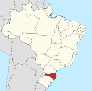
Santa Catarina is one of the 27 federative units of Brazil. It is located in the centre of the country's Southern region. It is bordered to the north by the state of Paraná, to the south by the state of Rio Grande do Sul, to the east by the Atlantic Ocean, and to the west by the Argentine province of Misiones.

<span class="mw-page-title-main">Chapecó</span> Municipality in Santa Catarina, Brazil

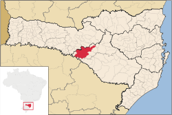
Chapecó is a municipality in the state of Santa Catarina, in the Southern Region of Brazil. Being a major industrial, financial and educational center, it is a major producer of industrialized food products. Considered a medium city, with a population estimated at 224,013 inhabitants, it is among the four most important cities in the state. It belongs to the Meso-region of Western Santa Catarina and to the Microregion of Chapecó.

<span class="mw-page-title-main">Brazilian Highway System</span> Highway system of Brazil

The Brazilian Highway System is a network of trunk roads administered by the Ministry of Transport of Brazil. It is constructed, managed and maintained by the National Department of Transport Infrastructure (DNIT), federal agency linked to the Ministry of Infrastructure, and the public works departments of state governments.

<span class="mw-page-title-main">Lages</span> Municipality in South, Brazil

Lages is a Brazilian municipality located in the central part of the state of Santa Catarina, in the region known in Portuguese as "Planalto Serrano".

<span class="mw-page-title-main">Contestado War</span> Guerrilla war for land between settlers and landowners, in Brazil

The Contestado War, broadly speaking, was a guerrilla war for land between settlers and landowners, the latter supported by the Brazilian state's police and military forces, that lasted from October 1912 to August 1916.

<span class="mw-page-title-main">José Maria de Santo Agostinho</span>

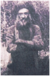
José Maria de Santo Agostinho, born Miguel Boaventura Lucena, was a Brazilian religious leader from the state of Santa Catarina. He was the third of three monks named João Maria who appeared in turn in southern Brazil, preaching and healing with herbs. He was the original leader of the peasants in the unsuccessful Contestado War (1912–16), and was killed in one of the first encounters with government troops.

<span class="mw-page-title-main">Tourism in Brazil</span> Overview of tourism in Brazil

Tourism is a growing sector and key to the economy of several regions of Brazil. The country had 6.589 million visitors in 2018, ranking in terms of the international tourist arrivals as the second main destination in South America after Argentina and third in Latin America after Mexico and Argentina. Revenues from international tourists reached US$5.8 billion in 2015, continuing a recovery trend from the 2008–2009 economic crisis.

<span class="mw-page-title-main">Roman Catholic Archdiocese of Florianópolis</span> Catholic ecclesiastical territory

The Roman Catholic Archdiocese of Florianópolis is an archdiocese located in the city of Florianópolis in Brazil.

<span class="mw-page-title-main">Russian Brazilians</span> Ethnic group

Russian Brazilians are Brazilian citizens of full or partial Russian ethnic background or Russian-born people residing in Brazil. The term can also refer to someone with a Brazilian mother and Russian father, or vice versa.

<span class="mw-page-title-main">Demographics of Brazil</span>

Brazil had an official resident population of 203 million in 2022, according to IBGE. Brazil is the seventh most populous country in the world, and the second most populous in the Americas and Western Hemisphere.

<span class="mw-page-title-main">São Joaquim</span> Municipality in South, Brazil

São Joaquim is a municipality in the state of Santa Catarina, situated in southern Brazil. Its population in 2020 was 27,139 inhabitants. Located in the Planalto Serrano, it lies 136 km from Tubarão, 81 km from Lages and 227 km from Florianópolis. The town is home to a variety of ethnic groups, including Italian, German, Portuguese, Japanese and Afro-Brazilians. There are also many people from other states in Brazil, especially from Rio Grande do Sul.

<span class="mw-page-title-main">Caçador</span> Municipality in South, Brazil

Caçador is a municipality in the state of Santa Catarina in the South region of Brazil.

São Mateus do Sul is a municipality of the Brazilian state of Paraná, located in the southern region of the country.

<span class="mw-page-title-main">Tietê Bus Terminal</span>

The Tietê Bus Terminal is the largest bus terminal in Latin America, and the second largest in the world, after the Port Authority Bus Terminal in New York City. The terminal is located in the Santana district in the city of São Paulo, Brazil. The official name in Portuguese is Terminal Rodoviário Governador Carvalho Pinto, named after Carlos Alberto Alves de Carvalho Pinto, a former Governor of the State of São Paulo.

<span class="mw-page-title-main">BR-116 (Brazil highway)</span> Highway in Brazil

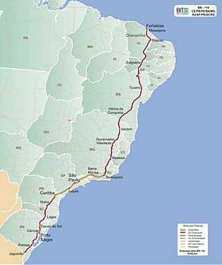
BR-116 is a federal route of highways of Brazil and the longest highway in the country, with 4,542 km (2,822 mi) of extension. The road connect Fortaleza, Ceará, one of the largest Northeast Brazil metropolises, to the southern city of Jaguarão, Rio Grande do Sul, in the border with Uruguay. It is also the longest highway in the country to be completely paved. It is considered one of the most important highways in the country, along with BR-101.

The Brazilian municipal elections of 2012 took place on October 7 and on October 28. Over 138 million voters chose mayors, deputy mayors and city councillors for the 5,568 municipalities of Brazil. These were the first elections in which the recently registered parties Partido Pátria Livre (PPL) and Partido Social Democrático (PSD) participated; they were both recognized by the Superior Electoral Court in 2011. Political parties whose candidates wished to run for the 2012 elections had to be registered at the TSE for at least one year before the election date, while candidates also had to be affiliated to a party for the same period of time. Conventions for the selection of candidates within the parties occurred between 10 and 30 June, while the registry of candidates and alliances with the Regional Electoral Courts took place until July 5. Electoral campaign was authorized from the moment a candidacy had been registered. The free electoral program – two daily slots on free-to-air TV and radio for political advertising paid by the Electoral Justice fund – ran weekdays from 21 August until 4 October. According to the current Brazilian electoral law, the two-round system – should the leading candidate receive less than 50% +1 of the votes – is only available for cities with more than 200,000 voters. This includes all state capitals, with the exception of Boa Vista, Roraima and Palmas, Tocantins, plus 59 other municipalities. The free electoral program for the second round ran from 13 October until 26 October.

<span class="mw-page-title-main">Captaincy of Santa Catarina</span> Former Portuguese captaincy in Brazil

The Captaincy of Santa Catarina was an administrative division of colonial Brazil created on August 11, 1738, in the southernmost territories of the Captaincy of São Paulo. The government was officially installed on March 7, 1739, with the first governor being José da Silva Pais.

<span class="mw-page-title-main">NSC TV Centro-Oeste</span> Television station in Santa Catarina, Brazil

NSC TV Centro-Oeste is a television station in Joaçaba, Santa Catarina, Brazil, affiliated with TV Globo, member of NSC TV and owned by NSC Comunicação. NSC TV Centro-Oeste's studios are located in the Cruzeiro do Sul district and its transmitter is located in the Boa Vista district.

References

  1. IBGE 2020
  2. "Airports in Santa Catarina". Archived from the original on 2018-05-08. Retrieved 2008-11-29.
  3. "World Meteorological Organization Climate Normals for 1991-2020 — Campos Novos". National Oceanic and Atmospheric Administration. Retrieved January 30, 2024.
  4. "Normais Climatológicas Do Brasil 1981–2010" (in Portuguese). Instituto Nacional de Meteorologia. Retrieved 21 May 2024.
  5. Enercan