
Trinity County is a county located in the northwestern portion of the U.S. state of California. Trinity County is rugged, mountainous, heavily forested, and lies along the Trinity River within the Salmon, Klamath Mountains, as well as a portion of the Scott, Trinity, and North Yolla Bolly Mountains. It is also one of three counties in California with no incorporated cities.
Fremont County is a county located in the U.S. state of Colorado. As of the 2020 census, the population was 48,939. The county seat is Cañon City. The county is named for 19th-century explorer and presidential candidate John C. Frémont.

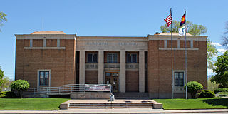
Cañon City is a home rule municipality that is the county seat and the most populous municipality of Fremont County, Colorado, United States. The city population was 17,141 at the 2020 United States Census. Cañon City is the principal city of the Cañon City, CO Micropolitan Statistical Area and is a part of the Front Range Urban Corridor. Cañon City straddles the easterly flowing Arkansas River and is a popular tourist destination for sightseeing, whitewater rafting, and rock climbing. The city is known for its many public parks, fossil discoveries, Skyline Drive, The Royal Gorge railroad, the Royal Gorge, and extensive natural hiking paths. In 1994, the United States Board on Geographic Names approved adding the tilde to the official name of Cañon City, a change from Canon City as the official name in its decisions of 1906 and 1975. It is one of the few U.S. cities to have the Spanish Ñ in its name, others being La Cañada Flintridge, California; Española, New Mexico; Peñasco, New Mexico; and Peñitas, Texas.

Klamath County was a county of California from 1851 to 1874. During its existence, the county seat moved twice and ultimately portions of the territory it once had were carved up and added to nearby counties. It was formed from the northwestern portion of Trinity County, and originally included all of the northwestern part of the state, from the Mad River in the south to Oregon in the north, from the Pacific Ocean in the west to the middle of what is now Siskiyou County in the east. It is the only county in California to be disestablished.
Canyon City, Cañon City, or Canon City may refer to:

The Diocese of El Camino Real is a diocese of the Episcopal Church in the United States of America, located in northern and central California. The diocese includes the cities of San Jose, Monterey, Santa Cruz, and San Luis Obispo. The diocese includes all Episcopal congregations in the counties of Santa Clara, Santa Cruz, San Benito, Monterey, and San Luis Obispo.

New Idria was an unincorporated town in San Benito County, California. It was named after the New Idria Mercury Mine, which closed in 1972, resulting in a ghost town.
Bidwell's Bar was a gold mining camp in Butte County, California, United States, which lay at the end of the California Trail. It was located 6.5 miles (10.5 km) east-northeast of Oroville, at an elevation of 902 feet.

Shasta is a census-designated place (CDP) in Shasta County, California, United States. Shasta sits at an elevation of 843 feet (257 m). Its population is 1,043 as of the 2020 census, down from 1,771 from the 2010 census.
Chloride City is a ghost town in Inyo County, California, United States. It is located 8.5 miles (14 km) north-northeast of Beatty Junction, at an elevation of 4,770 ft (1,450 m). The former settlement is in Death Valley National Park.

The South Central Colorado Urban Area comprises the Colorado Springs Metropolitan Statistical Area, the Pueblo Metropolitan Statistical Area, and the Cañon City Micropolitan Statistical Area in the central and south central region of the State of Colorado. With the exception of northern Teller County and small portions of northern El Paso County, the entire South Central Colorado Urban Area is drained by the Arkansas River and its tributaries. The South Central Colorado Urban Area is the southernmost of the three primary subregions of the Front Range Urban Corridor.
Kerby is an unincorporated community and census-designated place (CDP) in Josephine County, Oregon, United States, north of Cave Junction on U.S. Route 199. As of the 2010 census the population was 595. Despite its population and numerous businesses, it is often listed in tourist guides as a ghost town, because of the number of historic buildings left from its days as a gold-mining town. Kerby came into existence between 1854 and 1857.
North Bloomfield is a small unincorporated community located in Nevada County, California.
Rancho El Rincón was a 4,431-acre (17.93 km2) Mexican land grant in present-day San Bernardino County and Riverside County, California given in 1839 to Juan Bandini by Governor Juan Alvarado. El rincón means "the corner" in Spanish. The grant, located south of present-day Chino, was bounded on the east by Rancho Jurupa, on the south by the Santa Ana River, on the west by Rancho Cañón de Santa Ana, and extending northerly from the river one league. The rancho lands include Prado Regional Park.
Helena is a ghost town in unincorporated Trinity County, California, United States. It is located on the North Fork of the Trinity River, 10 miles (16 km) west-northwest of Weaverville. State Route 299 runs right past the former town to the south; East Fork Road connects the highway to Helena.
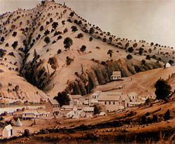
Minersville is a ghost town in Trinity County, California. The town was flooded by the creation of Trinity Lake.
Deadwood is a ghost town in Trinity County, California.
Dedrick is a ghost town in Trinity County, California.
Oreana is a ghost town in Pershing County, Nevada, United States.
