Related Research Articles
Northeast Glacier is a steep, heavily crevassed glacier, 13 nautical miles long and 5 nautical miles wide at its mouth, which flows from McLeod Hill westward and then south-westwards into Marguerite Bay between the Debenham Islands and Roman Four Promontory, on the west coast of Graham Land, Antarctica.
The Scott Mountains are a large number of isolated peaks lying south of Amundsen Bay in Enderby Land of East Antarctica, Antarctica. Discovered on 13 January 1930 by the British Australian New Zealand Antarctic Research Expedition (BANZARE) under Sir Douglas Mawson. He named the feature Scott Range after Captain Robert Falcon Scott, Royal Navy. The term mountains is considered more appropriate because of the isolation of its individual features.

Enderby Land is a projecting landmass of Antarctica. Its shore extends from Shinnan Glacier at about 67°55′S44°38′E to William Scoresby Bay at 67°24′S59°34′E, approximately 1⁄24 of the earth's longitude. It was first documented in western and eastern literature in February 1831 by John Biscoe aboard the whaling brig Tula, and named after the Enderby Brothers of London, the ship's owners who encouraged their captains to combine exploration with sealing.

Arrowsmith Peninsula is a cape about 40 miles (64 km) long on the west coast of Graham Land, west of Forel Glacier, Sharp Glacier and Lallemand Fjord, and northwest of Bourgeois Fjord, with Hanusse Bay lying to the northwest. It was surveyed by the Falkland Islands Dependencies Survey (FIDS) in 1955-58 and named for Edwin Porter Arrowsmith, Governor of the Falkland Islands.

Hut Point Peninsula is a long, narrow peninsula from 2 to 3 nautical miles wide and 15 nautical miles long, projecting south-west from the slopes of Mount Erebus on Ross Island, Antarctica. McMurdo Station (US) and Scott Base (NZ) are Antarctic research stations located on the Hut Point Peninsula.
Mount Bird is a 1,765 metres (5,791 ft) high shield volcano standing about 7 nautical miles south of Cape Bird, the northern extremity of Ross Island. It was mapped by the British National Antarctic Expedition, 1901–04, under Robert Falcon Scott, and apparently named by them after Cape Bird.

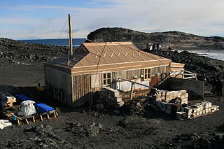
Cape Evans is a rocky cape on the west side of Ross Island, Antarctica, forming the north side of the entrance to Erebus Bay.
Cape Royds is a dark rock cape forming the western extremity of Ross Island, facing on McMurdo Sound, Antarctica. It was discovered by the British National Antarctic Expedition (BrNAE) (1901–1904) and named for Lieutenant Charles Royds, Royal Navy, who acted as meteorologist on the expedition. Royds subsequently rose to become an Admiral and was later Commissioner of the Metropolitan Police, London. The cape is the site of Shackleton's Hut, the expedition camp of the British Antarctic Expedition, 1907–09.
The Mariner Glacier is a major glacier over 60 nautical miles long, descending southeast from the plateau of Victoria Land, Antarctica, between Mountaineer Range and Malta Plateau, and terminating at Lady Newnes Bay, Ross Sea, where it forms the floating Mariner Glacier Tongue.
Surveyors Range is a 30 miles (48 km) long mountain range in the Churchill Mountains of Antarctica.
The Worcester Range is a high coastal range, about 30 nautical miles long, in Antarctica. It stands between Skelton Glacier and Mulock Glacier on the western side of the Ross Ice Shelf. It is southwest of the Royal Society Range and north of the Conway Range of the Cook Mountains.
The Boree Islands are two small islands 4 kilometres (2 nmi) west of Point Widdows, Enderby Land. They were plotted from air photos taken from Australian National Antarctic Research Expeditions aircraft in 1956, and named by the Antarctic Names Committee of Australia after "boree", a vernacular name for some species of acacia found in Australia.

Nicholson Peninsula is a broad ice-covered peninsula about 15 nautical miles (28 km) long, between Couzens Bay and Matterson Inlet on the Shackleton Coast on the west side of the Ross Ice Shelf, Antarctica.
Krasheninnikov Peak is a peak, 2,525 metres (8,280 ft) high, on the south side of the Svarthausane Crags in the Südliche Petermann Range of the Wohlthat Mountains, Antarctica. It was discovered and plotted from air photos by the Third German Antarctic Expedition, 1938–39, and was mapped from air photos and surveys by the Sixth Norwegian Antarctic Expedition, 1956–60. It was remapped by the Soviet Antarctic Expedition, 1960–61, and named after Russian geographer S.P. Krasheninnikov.
Cape Fletcher is a minor projection of the ice-covered Antarctic coastline south of Martin Reef, midway between Strahan Glacier and Scullin Monolith. It was discovered by the British Australian New Zealand Antarctic Research Expedition, 1929–31, under Mawson, and named by him for H.O. Fletcher, assistant biologist with the expedition.
McClary Glacier is a glacier 10 nautical miles (19 km) long and 2 nautical miles (4 km) wide on the west coast of Graham Land, Antarctica. It flows southwest along the north side of Butson Ridge into Marguerite Bay between Cape Calmette and the Debenham Islands. The glacier was first roughly surveyed by the British Graham Land Expedition, 1936–37, and resurveyed by the Falkland Islands Dependencies Survey, 1946–50. It was named by the UK Antarctic Place-Names Committee for George B. McClary, father of Nelson McClary, mate on the Port of Beaumont during the Ronne Antarctic Research Expedition, 1947–48.
Madigan Nunatak is an isolated nunatak that rises above the continental ice 18 nautical miles (33 km) south of Cape Gray, Antarctica. It was discovered by the Australasian Antarctic Expedition (1911–14) under Douglas Mawson, who named it for Cecil T. Madigan, the meteorologist with the expedition.
Rennick Bay is an embayment of the coastline of Antarctica at the terminus of Rennick Glacier. It is bounded on the west and east by Belousov Point and Stuhlinger Ice Piedmont.
Lainez Point is a point which forms the north side of the entrance to Dalgliesh Bay on the west side of Pourquoi Pas Island, off the west coast of Graham Land, Antarctica. It was discovered by the French Antarctic Expedition, 1908–10, under Jean-Baptiste Charcot, and named by him for Manuel Lainez, a senator of the Argentine Republic and founder of the newspaper El Diario.
References
- ↑ "Cape Monakov". Geographic Names Information System . United States Geological Survey, United States Department of the Interior . Retrieved 2013-10-31.
![]() This article incorporates public domain material from "Cape Monakov". Geographic Names Information System . United States Geological Survey.
This article incorporates public domain material from "Cape Monakov". Geographic Names Information System . United States Geological Survey.
| | This Enderby Land location article is a stub. You can help Wikipedia by expanding it. |