Cape San Blas Light

Last updated
Cape San Blas Light
Cape San Blas Light.jpg
Cape San Blas Light in its original location
Cape San Blas Light
Location Cape San Blas
southwest of Port St. Joe
Florida
United States
Coordinates 29°48′48″N85°18′23″W / 29.813199°N 85.306499°W / 29.813199; -85.306499 Coordinates: 29°48′48″N85°18′23″W / 29.813199°N 85.306499°W / 29.813199; -85.306499
Tower
Constructed1848 (first)
1859 (second)
1882 (third)
Foundationiron piling
Constructioncast iron skeletal tower
Height98 feet (30 m)
Shapesquare pyramidal skeleton tower with central cylinder, balcony and lantern
Markingswhite tower, black lantern
OperatorSt. Joseph Historical Society (Cape San Blas Lighthouse) [1] [2] [3]
HeritageNational Register of Historic Places listed place  OOjs UI icon edit-ltr-progressive.svg
Light
First lit1885 (current)
Automated1981
Deactivated1996
Focal height101 feet (31 m)
LensThird order Fresnel lens (1859)
Third order bivalve Fresnel lens (1906)
Range14 nautical miles; 26 kilometres (16 mi)
Characteristic Fl W 20s.
Cape San Blas Light and Keeper's Quarters
Nearest city Port St. Joe, Florida
NRHP reference No. 81000723 [4]
Added to NRHPJanuary 15, 1981

The Cape San Blas Light is a lighthouse in the state of Florida in the United States. There were four built between 1849 and 1885. It was located at Cape San Blas in the northwestern part of the state. Due to beach erosion and weather damage over the decades, it was moved in 2014 to Port St. Joe. The lighthouse was listed on the National Register of Historic Places in 2015.

Contents

History

The first Cape San Blas Light was completed in 1849 with an appropriation of $8,000 made 2 years earlier. The shoals running out from the cape extended 3.5 or 4.3 nautical miles; 6.4 or 8.0 kilometres (4 or 5 mi) and made it dangerous for all vessels nearing the coast. If the light had been high enough it could have been seen for 17 nautical miles; 32 kilometres (20 mi) and afforded protection to vessels going to and from Tortugas to New Orleans, but the light from the 85-or-90-foot (26 or 27 m) tower was visible only half that distance. The site was "deemed to be entirely secure from overflow or inundation" by the collector of customs at Apalachicola, Florida, who selected it, with the assistance of "two of our most experienced pilots."

The lighthouse erected in 1849 then "fell down during a gale in the autumn of 1851" and on August 31, 1852, Congress appropriated $12,000 for rebuilding it. The new structure was completed in 1856. It had been completed only a few months when during the severe storm of August 30, 1856, it was destroyed. "The sea rose so high," the United States Lighthouse Board reported, "that the waves struck the floor of the keeper’s dwelling, elevated 8 feet [2.4 m] above the ground, and about 14 feet [4.3 m] above the ordinary tides. A lagoon now occupies the site of the lighthouse." On March 3, 1857, Congress, for the third time, appropriated money for a lighthouse at Cape San Blas. This appropriation was for $20,000 and the new lighthouse was first lighted with a third-order lens on May 1, 1858.

The light station sustained serious damage at the hands of Union troops aboard the USS Kingfisher that landed in 1862 during the Civil War. The keeper's dwelling was completely destroyed and the door frames and sashes of the tower were torn or burnt out. Repairs were made, a new illuminating apparatus was provided, and the light was re-exhibited on July 23, 1865. In 1869 the beach in front of the lighthouse was reported to be washing away and would need protection against encroachments of the sea during heavy storms. In 1877 Congress appropriated $2,000 for protecting the site after the Lighthouse Board had reported 2 years earlier "The base of the tower is very nearly at the same level as the sea, which is but little more than 150 feet distant, the shore being of shifting sand. In a violent hurricane, it is feared, the tower may be undermined." The Board had asked for $5,000 to protect the site and reported in 1879 that, as it was found "impracticable to build a jetty for $2,000 that can protect the site from the encroachment of the sea, no further action has been taken in the matter."

The third Cape San Blas lighthouse (built in 1859) was destroyed by a storm in 1882 CapeSanBlasLighthouse, 1859.JPG
The third Cape San Blas lighthouse (built in 1859) was destroyed by a storm in 1882

Finally in 1881 the Board reported "The sea has been encroaching on this tower until its base is in the water. Brush mattresses were made, pinned down to the sand with small iron screw piles, covered with sand and occasionally blocks of concrete, to further check such encroachment, but the almost constant surf, beating against the mattresses, tore them to pieces. An appropriation for a new tower, further inland is badly needed. It is recommended that a skeleton iron tower be erected; then if the sea again encroaches, it could be taken down and re erected. The new tower will cost $25,000." The following year the Board noted "No appropriation was made; the site remained unprotected and on July 3, 1882, the tower was overthrown and completely destroyed." The Board strongly recommended that the tower be replaced on a safe site at an early date, there being no intervening light between San Blas and Pensacola, Florida, 120 miles (190 km or 220 km) distant.

An appropriation for a fourth tower was made available in 1883. The remains of the third tower were then 400 feet (120 m) distant from the shore, and the sea continued to erode the beach. By 1885 a fourth tower, a skeleton tower of iron, and two dwellings for keepers had been erected and the light was first displayed on June 30, 1885. The light had a third-order lens, showing alternate red and white flashes with 30 seconds intervals. The focal plane, 98 feet (30 m) above sea level, lit the entire horizon.

In 1887 the sea was reported again gradually cutting away the shore and during the year had washed away about one-third the distance to where the new tower had been built (300 feet or 100 m). Two years later only 200 feet (61 m) of beach remained and the Board reported "It is more than probable that this will be mostly washed away in the next 4 months." It was, therefore, recommended "that the tower and dwellings be taken down and removed to a point on the inside of the peninsula a little less than 1+12 miles [2.4 km], about northwest from its present position where there is a good site and 8+12 feet [2.6 m] of water, in St. Joseph Bay, within 400 or 500 yards (370 or 460 m) of it. This location is such that the bearing of the San Blas Shoals will be the same as now, and the increase of 1½ miles in the distance from the shore will be of little importance so far as its value as a coast light is concerned. It is estimated that to make the change will cost $20,000. The present site cannot be saved except at great cost."

Nothing had been done, however, by Congress and by early 1890 the tower was only 144 feet (44 m) from the sea at high-water mark. Later that year, however, an appropriation of $20,000 was made to remove the tower and dwellings to the point inside the peninsula. Condemnation proceedings to obtain title to the new site, however, dragged on until 1894 when on October 8 and October 9 a gale badly damaged the lighthouse extinguishing the light and wrecking the keeper's dwelling. So much of the cape was washed away that the tower now stood in the water.

Before the tower could be removed to the new site, it was decided in 1895 to remove the station to Black's Island, in St. Joseph Bay, which the President ordered reserved for lighthouse purposes. The work of dismantling the skeleton iron tower was begun in February 1896 and carried on until April 30 of that year when it was stopped because the appropriation was exhausted. The two keeper's houses had been relocated on Black's Island, the foundation for the tower was in place and three-fourths of the concrete work had been done, when it was estimated that $4,500 more would be required to finish the work. This was appropriated in June 1897.

Four months later, however, the light had been reestablished in the old tower, now in the water at the south point of Cape San Blas. In 1899 the Board reported "after careful consideration of all the conditions affecting the choice of a proper site, the Board has concluded that the light should be reconstructed on the shell ridge about 13 miles (21 km) N. by W. from its present location. It is estimated that this can be done at a cost not exceeding $15,000." This sum was appropriated on June 6, 1900, at which time the Board reported: "that the property and material stored at Black’s Island was being cared for by a watchman appointed for the purpose."

By 1901 nothing had been done about moving the tower and the Board reported "the advisability of removing the station to a new site is being considered, or of building a permanent keeper’s dwelling in place of the present temporary buildings, repairing the present light tower and permitting it to remain in the old location. The point of land on which the tower stands has made out until the beach at the nearest point is 100 or more feet distant from the tower. As this movement is increasing, it may become necessary to move the structure of the station to a new site." In 1903 the Board sought and obtained authority from Congress to use $7,000 of the $15,000 appropriated for moving the tower, to erect two keeper's dwellings at the old site. These were completed in 1905.

The light remained in the old tower until 1919. In 1916 it was reported "The sea is again making inroads on the station and a project for its removal has been tentatively approved." The new site was one-fourth mile (400 m) north of the old tower on the peninsula and on land heretofore reserved for military purposes, which the President forthwith reserved for lighthouse purposes. The tower was moved to this site in 1919. In 1923 the Black's Island reservation was sold. There were no buildings on the island at the time.

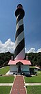
The light is now in a white, square skeleton tower, enclosing a stair cylinder, with the lantern 96 feet (29 m) above ground and 101 feet (31 m) above water. The 800,000 candela 3-foot 2-order electric light flashes white every 20 seconds and is visible 16 miles (26 km or 30 km). A radiobeacon was established at the station in 1939.

As of June 2012, the light has been added to the lighthouse Doomsday List.[ citation needed ]

Head keepers

Relocation

In July 2014, the lighthouse and two keepers' quarters were moved from Cape San Blas to George Core Park in Port St. Joe. 29°48′48″N85°18′23″W / 29.813217°N 85.306517°W / 29.813217; -85.306517 [6] [7]

Related Research Articles

Cape Hatteras Lighthouse Lighthouse in North Carolina, United States

Cape Hatteras Light is a lighthouse located on Hatteras Island in the Outer Banks in the town of Buxton, North Carolina and is part of the Cape Hatteras National Seashore. The lighthouse’s semi-unique pattern makes it easy to recognize and famous. It is often ranked high on lists of most beautiful, and famous lighthouses in the US.

Portland Head Light Historic lighthouse in the United States

Portland Head Light is a historic lighthouse in Cape Elizabeth, Maine. The light station sits on a head of land at the entrance of the primary shipping channel into Portland Harbor, which is within Casco Bay in the Gulf of Maine. Completed in 1791, it is the oldest lighthouse in Maine. The light station is automated, and the tower, beacon, and foghorn are maintained by the United States Coast Guard, while the former lighthouse keepers' house is a maritime museum within Fort Williams Park.

Point Iroquois Light Lighthouse in Michigan, United States

Point Iroquois Light is a lighthouse on a Chippewa County bluff in the U.S. state of Michigan. Point Iroquois and its light mark the division line between Whitefish Bay and the western end of the St. Marys River, the connection between Lake Superior and other Great Lakes.

Bald Head Light Lighthouse in North Carolina, US

Bald Head Lighthouse, known as Old Baldy, is the oldest lighthouse still standing in North Carolina. It is the second of three lighthouses that have been built on Bald Head Island since the 19th century to help guide ships past the dangerous shoals at the mouth of the Cape Fear river.

Race Rock Light Lighthouse

Race Rock Light is a lighthouse on Race Rock Reef, a dangerous set of rocks on Long Island Sound southwest of Fishers Island, New York and the site of many shipwrecks. It is currently owned and maintained by the New London Maritime Society as part of the National Historic Lighthouse Preservation Act program.

Hillsboro Inlet Light Lighthouse in Florida, United States

Hillsboro Inlet Lighthouse is a lighthouse located on the north side of Hillsboro Inlet, midway between Fort Lauderdale and Boca Raton, in Hillsboro Beach, Florida. The light marks the northern limit of the Florida Reef, an underwater coral formation on the lower east coast of the state.

Cape St. George Light Lighthouse in Florida, US

The Cape St. George Light is a 72-foot (22 m) high brick lighthouse which had originally stood for 153 years on St. George Island, Florida, until toppling into the Gulf of Mexico October 22, 2005. The pieces of the lighthouse were retrieved, and in April 2008, the light's restoration was completed.

Cape Canaveral Light Lighthouse in Florida, USA

The Cape Canaveral Light is a historic lighthouse on the east coast of the U.S. state of Florida. The light was established in 1848 to warn ships of the dangerous shoals that lie off its coast. It is located inside the Cape Canaveral Space Force Station and managed by the Space Launch Delta 45 of the U.S. Space Force with the assistance of the Cape Canaveral Lighthouse Foundation. It is the only fully operational lighthouse that is owned by the United States Space Force.

Old Presque Isle Light Lighthouse in Michigan, United States

The Old Presque Isle Light was the first lighthouse in the Presque Isle, Michigan area, built in 1840, supported physically by two-thirds stone and one-third brick, and supported financially by funds appropriated by Congress two years earlier of $5,000. The tower and dwelling did not last long in the harsh weather, however, and by 1867 they were deteriorated enough for Congress to find need for a newer station. It presently is not operational and is a museum.

Boon Island Light Lighthouse in Maine, United States

Boon Island Light is located on the 300-by-700-foot Boon Island off the southern coast of Maine, United States, near Cape Neddick. Boon Island Light has the distinction of being the tallest lighthouse in both Maine and New England at 133 feet (41 m). The lighthouse has a focal plane at 137 feet (42 m) above mean high water. The light's beacon flashes white every 5 seconds.

Alcatraz Island Lighthouse Lighthouse in the San Francisco Bay, California

Alcatraz Island Lighthouse is a lighthouse—the first one built on the U.S. West Coast—located on Alcatraz Island in California's San Francisco Bay. It is located at the southern end of the island near the entrance to the prison. The first light house on the island was completed in 1854, and served the bay during its time as a Citadel and military prison. It was replaced by a taller concrete tower built in 1909 to the south of the original one which was demolished after it was damaged due to earthquake in 1906. The automation of the lighthouse with a modern beacon took place in 1963, the year Alcatraz closed as the Alcatraz Federal Penitentiary. It is the oldest light station on the island with a modern beacon and is part of the museum on the island. Although when viewed from afar it easily looks the tallest structure on Alcatraz, it is actually shorter than the Alcatraz Water Tower, but as it lies on higher ground it looks much taller.

Five Mile Point Light Lighthouse in Connecticut, United States

Five Mile Point Light, also known as Five Mile Point Lighthouse or Old New Haven Harbor Lighthouse, is a U.S. lighthouse in Long Island Sound on the coast of New Haven, Connecticut. Located at the entrance to New Haven Harbor, the beacon's name derives from its proximity to Downtown New Haven, about five miles (8 km) away. The original lighthouse consisted of a 30-foot (9.1 m) octagonal wooden tower built in 1805 by Abisha Woodward. In 1847, a new 80-foot (24 m) octagonal tower was constructed by Marcus Bassett with East Haven brownstone. This new beacon was illuminated by 12 lamps with reflectors which were positioned 97 feet (30 m) above sea level. Also constructed at this time was a two-and-one-half story brick house which supplanted the previous, deteriorating keeper's dwelling. A fourth-order Fresnel lens replaced the lamps in 1855 and a fog bell was added in the 1860s. The Five Mile Point Light was deactivated in 1877 when the nearby Southwest Ledge Light was completed. Currently, the lighthouse is contained within Lighthouse Point Park and, along with the keeper's house, was listed on the National Register of Historic Places in 1990.

Cape Sarichef Light Lighthouse

Cape Sarichef Light is a lighthouse located on the northwest tip of Unimak Island, approximately 630 miles (1,010 km) southwest of Anchorage, Alaska. The most westerly and most isolated lighthouse in North America, Cape Sarichef Light marks the northwest end of Unimak Pass, the main passage through the Aleutian Islands between the Bering Sea and the Pacific Ocean. When it was first lit on July 1, 1904, it was Alaska's second coastal lighthouse, and the only staffed U.S. lighthouse on the Bering Sea. Today, the lighthouse is automated, and the beacon is mounted on a skeleton tower.

Point Sur Lighthouse Lighthouse in California, United States

Point Sur Lighthouse is a lightstation at Point Sur 24.6 miles (39.6 km) south of Monterey, California on top the 361-foot (110 m)-tall rock at the head of the point. It was established in 1889 and is part of Point Sur State Historic Park. The light house is 40 feet (12 m) tall and 270 feet (82 m) above sea level. As of 2016, and for the foreseeable future the light is still in operation as an essential aid to navigation. Point Sur is the only complete turn-of-the-20th-century lightstation open to the public in California. Three-hour walking tours guided by volunteers are available on Wednesdays and weekends throughout the year.

Pointe aux Barques Light Lighthouse in Michigan, United States

Pointe aux Barques Lighthouse is an active lighthouse located in Huron County in the U.S. state of Michigan. It is located along the shores of Lake Huron on the northeastern tip of the Thumb. Originally constructed in 1848, it is one of the oldest active lighthouses in the state. The name is translated as "point of little boats" from the French language, which refers to the shallow coastline that poses a threat to larger boats.

Hog Island Light Lighthouse in Virginia, United States

The Hog Island Light was a lighthouse roughly marking its eponymous island, and thus the north side of the Great Machipongo Inlet on the Virginia coast. Originally, no light existed between Cape Henlopen, Delaware and Cape Charles, Virginia. In 1830 the United States Congress appropriated money for a coastal beacon in the general vicinity of Chincoteague Island. The following year, the Collector of Customs in Norfolk selected Assateague Island.

Fuller Rock Light Lighthouse

The Fuller Rock Light was a lighthouse in Providence, Rhode Island. Destroyed in an explosion, it was replaced by a skeleton tower on the same foundation.

Ship Shoal Light Lighthouse in Louisiana, US

The Ship Shoal Light is a screw-pile lighthouse located in the Gulf of Mexico southwest of the Isles Dernieres off the coast of Louisiana. It is currently abandoned.

South Pass Light Lighthouse in Louisiana, US

The South Pass Light, also known as the Port Eads LighthouseSouth Point Light, or Gordon's Island Light, are a pair of lighthouses located on Gordon's Island at South Pass, in Plaquemines Parish, Louisiana (USA), one of the primary entrances to the Mississippi River Delta from the Gulf of Mexico. The light station was established in 1831 and is still active.

Pass A LOutre Light Lighthouse in Louisiana, US

The Pass A L'Outre Light is a defunct lighthouse in the Birdfoot Delta in Louisiana, United States, located near the mouth of the Mississippi River. Erected to mark the then-active entrance to the river, it was abandoned as that channel silted up. It has been in the path of several noteworthy hurricanes, and was heavily damaged. It is on the Lighthouse Digest Doomsday List, and is critically in danger. The lighthouse is at the center of a nature preserve.

References

  1. Cape San Blas Light Lighthouse Explorer. Retrieved 30 June 2016
  2. Rowlett, Russ (August 1, 2017). "Lighthouses of the United States: Western Florida". The Lighthouse Directory. University of North Carolina at Chapel Hill . Retrieved April 1, 2017.
  3. "Historic Light Station Information & Photography". U.S. Coast Guard History. December 21, 2016. Archived from the original on May 19, 2017. Retrieved April 1, 2019.
  4. "National Register Information System". National Register of Historic Places . National Park Service. July 9, 2010.
  5. Cape San Blas, FL Archived January 6, 2006, at the Wayback Machine Lighthouse Friends. Retrieved 30 June 2016
  6. 'Cape San Blas Lighthouse's Big Move' Archived March 4, 2016, at the Wayback Machine , by Jamie Hale, WJHG, July 15, 2014
  7. ‘This is history’ Archived February 15, 2015, at the Wayback Machine , by Tim Croft, Port St. Joe Star, July 31, 2014