
The Arctic Archipelago, also known as the Canadian Arctic Archipelago, is an archipelago lying to the north of the Canadian continental mainland, excluding Greenland.

Potosí is a department in southwestern Bolivia. It comprises 118,218 km2 with 823,517 inhabitants. The capital is the city of Potosí. It is mostly a barren, mountainous region with one large plateau to the west, where the largest salt flat in the world, Salar de Uyuni, is located.
The team dressage event, part of the equestrian program at the 2004 Summer Olympics, used the results of the first round of the individual dressage to award rankings. That round was held on 20 August and 21 August 2004 at the Olympic Equestrian Centre on the outskirts of Markópoulo, in the Attica region of Greece. Like all other equestrian events, the dressage competition was mixed gender, with both male and female athletes competing in the same division. 10 teams, each consisting of four horse and rider pairs, entered the contest.

Arque is a rural province in Cochabamba Department in the eastern cordillera of the South American state of Bolivia.

Ayopaya is a province in the Cochabamba Department, Bolivia. Its capital is Ayopaya.
Gualberto Villarroel is a province in the La Paz Department, Bolivia. Its capital is San Pedro de Curahuara de Carangas.

Gran Chaco is a province in the eastern parts of the Bolivian department Tarija. The province voted to become an autonomous region on 6 December 2009.

Capinota is a small town in the Bolivian Department of Cochabamba and capital of the Capinota Province.

The Cordillera Oriental or Eastern Cordillera is a set of parallel mountain ranges of the Bolivian Andes, emplaced on the eastern and north eastern margin of the Andes. Large parts of Cordillera Oriental are forested and humid areas rich in agricultural and livestock products. Geologically, the Cordillera Oriental is formed by the Central Andean fold and thrust belt.
Arque River is one of the headwaters of Río Grande and Mamoré River in Bolivia. Arque River has its source in the Kimsa Cruz mountain range on the western slope of the mountain Waylluma at 17°41′0″S66°43′30″W, 50 km northeast of the mining city Oruro and 65 km southwest of Cochabamba.
Santiváñez is a locality in the Cochabamba Department in central Bolivia. It is the capital of Santiváñez Municipality, the second municipal section of the Capinota Province. At the time of census 2001 it had a population of 1,046.
Sicaya or Silaya is a locality in the Cochabamba Department in central Bolivia. It is the seat of the Sicaya Municipality, the third municipal section of the Capinota Province.

The Yukon Flats are a vast area of wetlands, forest, bog, and low-lying ground centered on the confluence of the Yukon River, Porcupine River, and Chandalar River in the central portion of the U.S. state of Alaska. The Yukon Flats are bordered in the north by the Brooks Range, in the south by the White Mountains, and cover an area of approximately 11,000 square miles (28,490 km2). The Yukon Flats are a critical waterfowl breeding ground due to the large area of wetland provided by the estimated 40,000 small lakes and streams in the area. In recognition of this fact, the area is protected under the Yukon Flats National Wildlife Refuge.
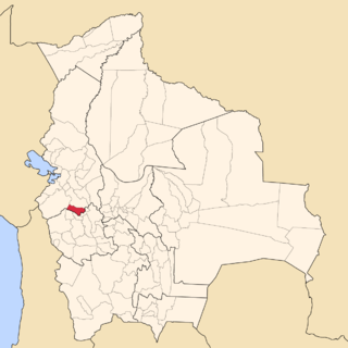
Capinota Municipality is the first municipal section of the Capinota Province in the Cochabamba Department, Bolivia. Its seat is Capinota.
Santiváñez Municipality is the second municipal section of the Capinota Province in the Cochabamba Department, Bolivia. Its seat is Santiváñez.
Sicaya Municipality is the third municipal section of the Capinota Province in the Cochabamba Department in Bolivia. Its seat is Sicaya.
The Land Glacier is a broad, heavily crevassed glacier, about 35 nautical miles (60 km) long, descending into Land Bay in Marie Byrd Land, Antarctica. It was discovered by the U.S. Antarctic Service (1939–41) and named for Rear Admiral Emory S. Land, Chairman of the U.S. Maritime Commission.
Erskine Glacier is a glacier 16 nautical miles (30 km) long on the west coast of Graham Land, flowing west into Darbel Bay to the north of Hopkins Glacier. It was first surveyed by the Falkland Islands Dependencies Survey (FIDS) in 1946–47, and named "West Gould Glacier". With East Gould Glacier it was reported to fill a transverse depression across Graham Land, but further survey in 1957 showed no close topographical alignment between the two. The name Gould has been limited to the east glacier and an entirely new name, for Angus B. Erskine, leader of the first FIDS party to travel down the glacier and to survey it in detail, has been approved for the west glacier.

Lewis Glacier is the northerly of two glaciers flowing from Hemimont Plateau east into Seligman Inlet, on the east coast of Graham Land, Antarctica. The glacier was photographed from the air by the United States Antarctic Service in 1940. It was charted in 1947 by the Falkland Islands Dependencies Survey, who named it for British glaciologist William Vaughan Lewis, a lecturer at the Department of Geography, Cambridge University.

