Caples Lake

Last updated
Caples Lake
Caples Lake, California State Route 88, Kirkwood, California.jpg
View from Caples Lake with Elephants Back to left and Round Top centered.
Relief map of California.png
Red pog.svg
Caples Lake
Location Alpine County, California
Coordinates 38°41′55″N120°02′44″W / 38.69861°N 120.04556°W / 38.69861; -120.04556 [1]
Primary inflows Woods Creek
Primary outflows Caples Creek
Basin  countriesUnited States
Max. length2 miles (3.2 km)
Surface area600 acres (2.4 km2)
Max. depth62 feet (19 m)
Surface elevation7,802 ft (2,378 m)

Caples Lake is a reservoir that is located near Kirkwood, California along California State Route 88 (also known as the Carson Pass Highway). [2] The lake was used as a halting place for wagon travelers who were trekking the historic Mormon Trail during the California Gold Rush. The lake has been used by many different groups of people including Native Americans, 49ers, and resort owners, so it has been known by different names. The variant names are Clear Lake, Summit Lake, and Twin Lakes. [1] Currently, Caples Lake is a reservoir used for water and recreation. Woods Creek and Emigrant Creek both flow into Caples Lake, which drains into Caples Creek. [3] Caples Creek meets up with the South Fork of the American River. It is operated by the El Dorado Irrigation District (EID), who is using it as part of the Hydroelectric Project 184 system.

Contents

El Dorado Irrigation District Management

The EID obtained the license for Project 184 (the El Dorado Hydroelectric Project) in 2006, and it had requirements that the EID monitor flows, recreation, and environmental conditions within their system. [4] The EID also manages the recreational facilities at Caples Lake, such as the boat launch, day use areas, and bathrooms with the help of the Eldorado National Forest as part of the license agreement. [5] The Project 184 system has four reservoirs, including Caples Lake, a diversion dam along the South Fork of the American River, and a hydropower facility located at Forbay Reservoir. The water that gets diverted goes through the El Dorado Canal which brings water to Forbay Reservoir. That water is used to generate power at the El Dorado Powerhouse for Pacific Gas and Electric (PG&E) and provides some consumptive water for the El Dorado Irrigation District. [4]

History

The Washoe people occupied the area before the gold rush attracted many new settlers. The Washoe people referred to Caples Lake as Twin Lakes because the area was historically an open meadow with two shallow lakes that they were able to fish, hunt, and forage around. [6] The next person to occupy the area was Dr. James Caples, who passed by the lake in 1849 on his trek to the gold country. He later returned and bought the area that is now Caples Lake to raise cattle and set up a trading post for travelers that was around for thirty years. The way-station could only be opened up during the summer months due to its high elevation but it still served as a very important stop for 49ers, which is why the lake was named after Dr. Caples. Caples Dam was originally constructed in 1922 by damming up Caples Creek. After the gold rush ended, the way-station transitioned into a resort for travelers. A man named Ray Koenig was the first to construct a resort in 1948, however, he owned it before California State Route 88 was built, so he had to ski all the way from California State Route 50 to set up the resort each year. [6] Since Koenig, there have been several owners of the resort who made improvements to the lodging and dam and tried to keep it running during the winter. The opening of Kirkwood Ski Resort in 1972 allowed California State Route 88 to remain open as a winter travel route, making it easier for the resort to remain open year-round. The Caples Lake resort is currently owned by the Voss family, who keep it open during the winter months. [6]

Recreation

Caples Lake is located in the Eldorado National Forest, meaning that there are a variety of different recreational opportunities such as hiking, fishing, and skiing within close proximity. The California Department of Fish and Wildlife (CDFW) has reports of stocking Caples Lake with fish for recreational fishing dating back to 1930. Currently, the regulations for Caples Lake state that fishermen are only allowed to take home five trout that are a minimum of ten inches each. [3] Both the CDFW and the EID stock Caples lake with rainbow trout and brown trout. Caples Lake also supports a few non-stocked species such as the Lahontan redsides, the tui chub, and the lake trout. [3] There is year-round fishing at Caples Lake, boat access in the summer and ice fishing in the winter. There are also many trailheads located near Caples Lake that enter into Mokelumne Wilderness. The names of the trailheads are Lake Margaret Trailhead, Meiss Lake Trailhead, Thunder Mountain Trailhead, Frog Lake Trailhead (also called Roundtop Trailhead), and Shealor Lake Trailhead. [5] The access for these trailheads are also along California State Route 88.

Climate

Caples Lake has a humid continental climate (Dsb according to the Köppen climate classification), with warm, dry summers and cold, snowy winters due to the high elevation.

Climate data for Caples Lake, California, 1981–2010 normals, extremes 1924–2000
MonthJanFebMarAprMayJunJulAugSepOctNovDecYear
Record high °F (°C)64
(18)
66
(19)
70
(21)
78
(26)
82
(28)
92
(33)
95
(35)
91
(33)
88
(31)
83
(28)
72
(22)
70
(21)
95
(35)
Average high °F (°C)40.0
(4.4)
39.7
(4.3)
43.9
(6.6)
48.6
(9.2)
57.3
(14.1)
65.7
(18.7)
73.8
(23.2)
72.7
(22.6)
67.1
(19.5)
56.6
(13.7)
45.9
(7.7)
40.1
(4.5)
54.3
(12.4)
Daily mean °F (°C)28.7
(−1.8)
28.0
(−2.2)
31.2
(−0.4)
35.3
(1.8)
43.2
(6.2)
51.3
(10.7)
58.0
(14.4)
57.3
(14.1)
51.8
(11.0)
42.6
(5.9)
33.8
(1.0)
28.4
(−2.0)
40.8
(4.9)
Average low °F (°C)17.4
(−8.1)
16.4
(−8.7)
18.5
(−7.5)
22.3
(−5.4)
29.0
(−1.7)
37.0
(2.8)
42.3
(5.7)
42.0
(5.6)
36.6
(2.6)
28.6
(−1.9)
21.7
(−5.7)
16.7
(−8.5)
27.4
(−2.6)
Record low °F (°C)−26
(−32)
−24
(−31)
−18
(−28)
−14
(−26)
−4
(−20)
7
(−14)
20
(−7)
20
(−7)
10
(−12)
1
(−17)
−9
(−23)
−19
(−28)
−26
(−32)
Average precipitation inches (mm)7.08
(180)
7.84
(199)
6.32
(161)
3.41
(87)
2.72
(69)
0.97
(25)
0.44
(11)
0.62
(16)
1.16
(29)
2.93
(74)
6.04
(153)
7.48
(190)
47.01
(1,194)
Average snowfall inches (cm)73.5
(187)
61.8
(157)
72.4
(184)
32.5
(83)
7.0
(18)
1.8
(4.6)
0.0
(0.0)
0.0
(0.0)
2.4
(6.1)
10.8
(27)
47.1
(120)
65.7
(167)
375.0
(953)
Average precipitation days (≥ 0.01 in)10.79.99.77.17.24.52.42.35.25.29.510.183.8
Average snowy days (≥ 0.1 in)10.29.08.75.52.40.80.00.00.92.17.59.456.5
Source 1: NOAA [7]
Source 2: XMACIS2 [8]

Related Research Articles

<span class="mw-page-title-main">Deschutes River</span> River in Oregon, United States

The Deschutes River in central Oregon is a major tributary of the Columbia River. The river provides much of the drainage on the eastern side of the Cascade Range in Oregon, gathering many of the tributaries that descend from the drier, eastern flank of the mountains. The Deschutes provided an important route to and from the Columbia for Native Americans for thousands of years, and then in the 19th century for pioneers on the Oregon Trail. The river flows mostly through rugged and arid country, and its valley provides a cultural heart for central Oregon. Today the river supplies water for irrigation and is popular in the summer for whitewater rafting and fishing.

<span class="mw-page-title-main">Truckee River</span> River in Nevada and California, United States

The Truckee River is a river in the U.S. states of California and Nevada. The river flows northeasterly and is 121 miles (195 km) long. The Truckee is the sole outlet of Lake Tahoe and drains part of the high Sierra Nevada, emptying into Pyramid Lake in the Great Basin. Its waters are an important source of irrigation along its valley and adjacent valleys.

<span class="mw-page-title-main">Curecanti National Recreation Area</span> National Park Service in Colorado, US

Curecanti National Recreation Area is a National Park Service unit located on the Gunnison River in western Colorado. Established in 1965, Curecanti National Recreation Area is responsible for developing and managing recreational facilities on three reservoirs, Blue Mesa Reservoir, Morrow Point Reservoir and Crystal Reservoir, constructed on the upper Gunnison River in the 1960s by the U.S. Bureau of Reclamation to better utilize the vital waters of the Colorado River and its major tributaries. A popular destination for boating and fishing, Curecanti offers visitors two marinas, traditional and group campgrounds, hiking trails, boat launches, and boat-in campsites. The state's premiere lake trout and Kokanee salmon fisheries, Curecanti is a popular destination for boating and fishing, and is also a popular area for ice-fishing in the winter months.

<span class="mw-page-title-main">Lake Berryessa</span> Reservoir in California, United States

Lake Berryessa is the largest lake in Napa County, California. This reservoir in the Vaca Mountains was formed following the construction of the Monticello Dam on Putah Creek in the 1950s. Since the early 1960s, this reservoir has provided water and hydroelectricity to the North Bay region of the San Francisco Bay Area.

<span class="mw-page-title-main">Stevens Creek Reservoir</span> Reservoir in Santa Clara County, California

Stevens Creek Reservoir is an artificial lake located in the foothills of the Santa Cruz Mountains near Cupertino, California. A 1,063-acre (430 ha) county park surrounds the reservoir and provides limited fishing, picnicking, hiking, and horseback riding activities. Although swimming is not allowed, non-power boating is allowed for certain parts of the year. No powered boats or jet skis are allowed. All vessels must be inspected for invasive Quagga mussels prior to launch.

<span class="mw-page-title-main">Foster Reservoir</span> Reservoir in Oregon, United States

Foster Reservoir is a reservoir created by Foster Dam on the South Santiam River in the city of Foster, Oregon, United States. The reservoir is approximately 5.6 km (3.5 mi) long and covers approximately 494 ha when full. Primary use of the reservoir is recreation in the summer and flood control in the winter and spring.

<span class="mw-page-title-main">Huntington Lake</span> Reservoir in California, US

Huntington Lake is a reservoir in Fresno County, California on Big Creek, located in the Sierra Nevada at an elevation of 6,955 feet (2,120 m). The lake receives water from Southern California Edison's Big Creek Hydroelectric Project, as well as the many streams that flow into the lake. Some water leaving the lake flows to Big Creek, while some is diverted to nearby Shaver Lake. The lake is home to a variety of recreational activities, including camping, horse-back riding, skiing, sailing, fishing and more. It is drained and refilled through the Big Creek dam system each year, with winter water levels often dipping below 50 percent of the lake's capacity.

<span class="mw-page-title-main">Fallen Leaf Lake</span> Lake in the state of California, United States

Fallen Leaf Lake is a mountain lake located in El Dorado County, California, near the California–Nevada state border, about one mile south west of the much larger Lake Tahoe. It is approximately aligned north-to-south and oval in shape, measuring approximately 2.9 miles (4.6 km) on the long axis and 0.9 miles (1.4 km) on the short axis. The lake was created by at least two glaciers that traveled northward down the Glen Alpine Valley. If the glacier had continued instead of stopping, Fallen Leaf Lake would be a bay of Lake Tahoe, similar to nearby Emerald Bay. A terminal moraine is visible at the north end of the lake on the northeast edge.

<span class="mw-page-title-main">Folsom Lake</span> Reservoir on the American River in the Sacramento metropolitan area

Folsom Lake is a reservoir on the American River in the Sierra Nevada foothills of California, United States.

<span class="mw-page-title-main">Whiskeytown Lake</span> Man-made reservoir in California, United States

Whiskeytown Lake is a reservoir in Shasta County in northwestern California, United States, about 8 miles (13 km) west of Redding. The lake is in the Whiskeytown Unit of the Whiskeytown-Shasta-Trinity National Recreation Area.

<span class="mw-page-title-main">Loon Lake (California)</span> Reservoir in El Dorado County, California

Loon Lake is a reservoir in the Eldorado National Forest of El Dorado County, California, United States. The 76,200 acre⋅ft (94,000,000 m3) lake is formed by Loon Lake Dam, completed in 1963 as part of the Upper American River Project by Sacramento Municipal Utility District to conserve spring snow melt runoff for use during the summer and autumn for hydroelectric power production. Loon Lake Dam impounds water at the headwaters of Gerle Creek which, prior to the dam, flowed intermittently through (natural) Loon and Pleasant Lakes. But most of the water now stored in Loon Lake arrives from Buck Island Reservoir in the adjacent Rubicon River watershed by way of the Buck-Loon Tunnel. Nearby is Loon Lake Chalet, a popular winter recreation destination. In summer, a boat ramp for water sports and camping are available, but the area is less popular than nearby Union Valley Reservoir and Rubicon Trail.

<span class="mw-page-title-main">Crooked River (Oregon)</span> River in Oregon, United States

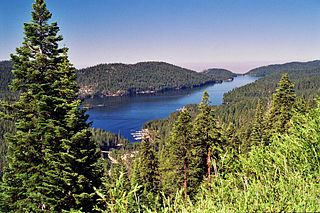
The Crooked River is a tributary, 125 miles (201 km) long, of the Deschutes River in the U.S. state of Oregon. The river begins at the confluence of the South Fork Crooked River and Beaver Creek. Of the two tributaries, the South Fork Crooked River is the larger and is sometimes considered part of the Crooked River proper. A variant name of the South Fork Crooked River is simply "Crooked River". The Deschutes River flows north into the Columbia River.

<span class="mw-page-title-main">Puddingstone Reservoir</span> Reservoir in Los Angeles County, California

Puddingstone Reservoir is a 250-acre (1 km²) artificial lake northeast of the interchange between the Orange Freeway and the San Bernardino Freeway in Los Angeles County, California, United States. Activities include fishing, swimming, sailing, windsurfing, and camping. It is fed by Live Oak Wash and drains into Walnut Creek.

<span class="mw-page-title-main">Hyatt Reservoir</span> Reservoir, eutrophic in Jackson County, Oregon

Hyatt Reservoir is a reservoir in Jackson County, Oregon, United States, 14 miles (23 km) east of Ashland. Impounded by Hyatt Dam, the water is used for irrigation and recreation. A local irrigation district built the dam in 1923.

<span class="mw-page-title-main">American River</span> River in California, United States

The American River is a 30-mile (50 km)-long river in California that runs from the Sierra Nevada mountain range to its confluence with the Sacramento River in downtown Sacramento. Via the Sacramento River, it is part of the San Francisco Bay watershed. This river is fed by the melting snowpack of the Sierra Nevada and its many headwaters and tributaries, including the North Fork American River, the Middle Fork American River, and the South Fork American River.

<span class="mw-page-title-main">Sly Park Dam</span> Dam in El Dorado County, California

Sly Park Dam is located near Pollock Pines, California in the United States. The dam impounds Sly Park Creek and Hazel Creek, natural tributaries of the North Fork Cosumnes River, to form a 41,000 acre-foot (51,000 dam3), 650-acre (260 ha) reservoir called Jenkinson Lake. It was constructed as part of the American River Division of the Central Valley Project to provide irrigation water to a portion of El Dorado County, California. The dam was begun in May 1953, with clearing operations, and was completed in mid 1955.

<span class="mw-page-title-main">Upper Stillwater Reservoir</span> Reservoir in the state of Utah, United States

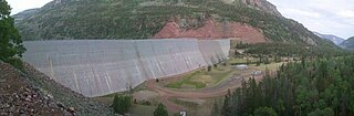
Upper Stillwater Reservoir is a large high mountain reservoir on the south slope of the High Uintas in Duchesne County, Utah. The reservoir is part of the Central Utah Project.

<span class="mw-page-title-main">Prosser Creek Dam</span> Dam in Nevada County, California, United States of America

Prosser Creek Dam is a dam in Nevada County, California.

<span class="mw-page-title-main">Lake Thomas A Edison</span> Reservoir in Fresno County, California

Lake Thomas A Edison is a reservoir in the Sierra National Forest and in Fresno County, California. It is in the Sierra Nevada, and near the Pacific Crest Trail.

<span class="mw-page-title-main">Silver Lake (Amador County, California)</span> Reservoir in Northern California

Silver Lake is a reservoir in the Sierra Nevada mountains of California.

References

  1. 1 2 "Caples Lake". Geographic Names Information System . United States Geological Survey, United States Department of the Interior.
  2. Ruppenstein, Andrew (2016). "Caples Lake Historical Marker". www.hmdb.org. Retrieved 2019-04-22.
  3. 1 2 3 Ewing, Ben (2016). "State of California, California Department of Fish and Wildlife North Central Region Caples Lake, Alpine County 2015 Angler Survey Box Analysis". California Department of Fish and Wildlife.
  4. 1 2 El Dorado Irrigation District. "Project 184" . Retrieved 2019-04-22.
  5. 1 2 "Caples Lake | El Dorado Irrigation District". www.eid.org. Retrieved 2019-04-22.
  6. 1 2 3 "The History of Caples Lake Resort". 2013. Retrieved 2019-04-22.
  7. "U.S. Climate Normals Quick Access – Station: Twin Lakes, CA". National Oceanic and Atmospheric Administration. Retrieved February 19, 2023.
  8. "xmACIS2". National Oceanic and Atmospheric Administration. Retrieved February 19, 2023.