
Hurlstone Park is a suburb in the Inner West of Sydney, New South Wales, Australia. Hurlstone Park is located nine kilometres south-west of the Sydney central business district and is mostly in the local government area of the City of Canterbury-Bankstown, and partly in the Inner West Council. The suburb is bounded by: the Cooks River to the south, Garnet Street to the east, New Canterbury Road to the north, Canterbury Road to the north-west, and Church Street to the west.

The Town of Victoria Park is a local government area of Western Australia. It covers an area of 17.62 km² in metropolitan Perth, the capital of Western Australia. It had a population of approximately 35,000 as at the 2016 census.

Armadale railway station is a commuter railway station in Armadale, a suburb of Melbourne, Victoria, Australia. The station is listed on the Victorian Heritage Register and was opened on 7 May 1879. The station consists of an island platform and two side platforms, all accessed by a pedestrian bridge. There are two principal station buildings located on the central platform and on platform 4, consisting of a small two and one-story brick buildings. These buildings were provided in 1914 as ticketing and staff offices. The station is only partially accessible due to a multiple steep access ramps.

Padstow, a suburb of local government area City of Canterbury-Bankstown, is located 21 kilometres south-west of the Sydney central business district, in the state of New South Wales, Australia, and is a part of the South-western Sydney region. Padstow is a mostly residential suburb bounded on the north by Bankstown and on the east by Salt Pan Creek, which is a stream feeding into the Georges River. The M5 South Western Motorway traverses the northern end of the suburb, which is also the location of a number of light industrial facilities.
Cloverdale is a suburb of Perth, the capital city of Western Australia, 10 kilometres (6 mi) east of Perth's CBD in the City of Belmont.

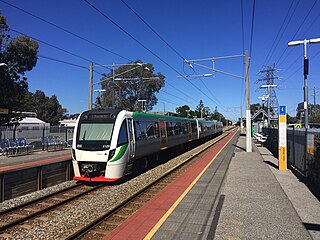
The Armadale line is a suburban railway service in Perth, Western Australia, operated by the Public Transport Authority as part of the Transperth system. The Armadale line is 30.4 kilometres (18.9 mi) long, and starts at Perth station, heading south-east of there to serve Perth's south-eastern suburbs, terminating at Armadale station.
Armadale railway station is located on the South Western Railway, 30 kilometres from Perth station serving the suburb of Armadale, Brookdale and Haynes. It is the terminating point for Transperth Armadale line services and a calling point for Transwa Australind services.

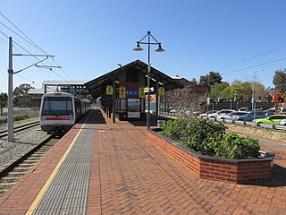
Sherwood railway station is a suburban railway station in Armadale, a suburb of Perth, Western Australia. It is on the Armadale line which is part of the Transperth network, and is 28.6 kilometres (17.8 mi) southwest of Perth station and 1.8 kilometres (1.1 mi) north of Armadale station. The station opened in 1973 as Kingsley, but was renamed to Sherwood in 1993. It consists of two side platforms with a pedestrian level crossing. It is not fully accessible due to steep ramps, wide gaps at the pedestrian level crossing, and wide gaps between the platform and train. Services are operated by Transperth Train Operations, a division of the state government's Public Transport Authority. Peak services reach seven trains per hour in each direction, whilst off-peak services are four trains per hour.

Kelmscott railway station is located on the South Western Railway, 25.9 kilometres from Perth Station in the suburb of Kelmscott. It is served by Armadale Line services which are part of the Transperth network.
Cannington is a temporarily closed railway station on the Armadale and Thornlie lines, serving the suburb of Cannington south of Perth, Western Australia. It is located 12.2 kilometres (7.6 mi) from Perth Station, and is part of the Transperth commuter rail network. It temporarily closed on 20 November 2023 as part of the Victoria Park-Canning Level Crossing Removal Project.
Oats Street railway station is a temporarily-closed Transperth suburban railway station in Western Australia, located in the Perth suburbs of Carlisle and East Victoria Park. The station was served by the Armadale and Thornlie lines prior to its closure in November 2023.

Carlisle railway station is a temporarily-closed suburban railway station on the Transperth network in Western Australia. It is in the Perth suburbs of Carlisle and East Victoria Park, and was predominantly served by Thornlie line services prior to its closure in November 2023.

Lathlain railway station was a suburban railway station on the Transperth network in Western Australia. It was on the Armadale line in the Perth suburbs of Lathlain and Victoria Park. The station opened on 2 May 1958 to serve Lathlain Park, the home ground of the Perth Football Club. The station closed on 2 February 2003 due to low patronage, its close distance to the adjacent Carlisle and Victoria Park stations, and the need to lower the railway line to build the Miller Street/Roberts Road bridge.

Victoria Park railway station is a suburban railway station on the Transperth network in Western Australia. The station is in the Perth suburbs of Lathlain and Victoria Park. Since November 2023, the station has been the terminus of the Armadale and Thornlie lines due to the Victoria Park-Canning Level Crossing Removal Project. The whole of each line is expected to reopen in mid-2025.

Kewdale is a suburb of Perth, Western Australia within the City of Belmont. Kew Street was one of the first roads in this district, hence the naming of the suburb.

Bentley is a southern suburb of Perth, the capital city of Western Australia, 8 kilometres (5.0 mi) southeast of Perth's central business district. Its local government areas are the City of Canning and the Town of Victoria Park. Bentley is home to the main campus of Curtin University and Technology Park.
Lathlain is an inner south eastern suburb of Perth, Western Australia. Its local government area is the Town of Victoria Park.

William Street is a suburban distributor and one of two major cross-streets in the central business district of Perth, Western Australia. Commencing in western Mount Lawley, its route takes it through the Northbridge café and nightclub district as well as the CBD.

The Victoria Park-Canning Level Crossing Removal Project is a project by the Government of Western Australia to elevate part of the Armadale line, thereby removing six level crossings and rebuilding five stations to modern standards. The project is a part of the wider Metronet initiative undertaken by the state government. The stations to be rebuilt as part of the project are, from north to south, Carlisle, Oats Street, Queens Park, Cannington, and Beckenham. Welshpool station will be closed due to low patronage and technical constraints. The level crossings to be removed as part of the project are Mint Street, Oats Street, Welshpool Road, Hamilton Street, Wharf Street, and William Street.

