East Victoria Park, Western Australia

Last updated

East Victoria Park
Perth,  Western Australia
Albany Hwy 026 S EVP Balmoral Hotel.jpg
Albany Highway running through the centre of East Victoria Park
East Victoria Park, Western Australia
Coordinates 31°59′17″S115°54′14″E / 31.988°S 115.904°E / -31.988; 115.904
Population10,569 (SAL 2021) [1]
Established1890s
Postcode(s) 6101
Area4 km2 (1.5 sq mi)
Location6 km (4 mi) from Perth
LGA(s) Town of Victoria Park
State electorate(s) Victoria Park and South Perth
Federal division(s) Swan
Suburbs around East Victoria Park:
Victoria Park
Kensington
Victoria Park
Lathlain
Carlisle
Kensington East Victoria Park Carlisle
Welshpool
Bentley Bentley
St James
St James

East Victoria Park (nicknamed East Vic Park) is an inner south-eastern suburb of Perth, Western Australia, located within the Town of Victoria Park.

Contents

East Victoria Park is located south-east of the suburb of Victoria Park, approximately 5 kilometres (3.1 mi) from the Perth central business district. It is primarily residential but includes a continuation of the Albany Highway commercial strip. It is bounded by the Armadale-Thornlie railway line to the north-east and shares Carlisle and Oats Street railway stations with the neighbouring suburb of Carlisle.

Landmarks

East Victoria Park includes the Edward Millen Home (originally the Rotunda Hospital), a complex of buildings in the Federation Queen Anne architectural style. The precinct is listed on the State Register of Heritage Places. [2]

In 1911, the Australian Aborigines Mission established the Dulhi Gunyah home for Noongar children on the corner of Kent Street and Jarrah Road. The home was closed in 1916 and the children were moved to the Carrolup Native Settlement. The facility was later purchased by the Methodist Church and was used as a children's home for wards of the state. It was renamed Mofflyn in 1959 and became part of the Uniting Church. It was eventually demolished and cleared, with the Victoria Heights residential estate constructed on the site in the late 1990s. [3]

History

East Victoria Park was opened for residential subdivision in the early 1900s, with early housing estates including Bickford Estate, Brixton Township, Canterbury Park, Canning Park, Hillcrest Estate and Balmoral Estate. Development was spurred by the extension of the Perth tramways in 1905, with the line running down what is now Albany Highway. It was extended to a terminus at Patricia Street in 1934, and during World War II was further extended to a munitions factory on Welshpool Road. The tramways were closed in 1950 and replaced with bus services. [4]

A railway station on the South Western Railway was opened at Mint Street in 1912 – originally named East Victoria Park station but renamed Carlisle station in 1919. This was joined by Oats Street station further to the east in 1954. [5]

After World War II, bushland to the west of Berwick Street adjoining the Collier Pine Plantation was opened for residential subdivision. This area was originally known as the Millen Estate and included a number of war service homes. Many residents found work in the Welshpool industrial area. New schools were built in the 1950s, including Millen Primary School and St. Francis Xavier College (now part of Ursula Frayne Catholic College), while East Victoria Park Primary School was relocated to its present site in 1977. [6]

Transport

Bus

Bus routes serving Albany Highway, Basinghall Street and Berwick Street:

Bus routes serving Shepperton Road:

Rail

Related Research Articles

<span class="mw-page-title-main">Armadale, Western Australia</span> Suburb of Perth, Western Australia

Armadale is a suburb of Perth within the City of Armadale, located on the south-eastern edge of the Perth metropolitan region. The major junction of the South Western and Albany Highways, which connect Perth with the South West and Great Southern regions of Western Australia respectively, is located within the suburb. It is also the terminus of the Armadale railway line, one of five major railway lines to service Perth.

<span class="mw-page-title-main">Como, Western Australia</span> Suburb of Perth, Western Australia

Como is a suburb of Perth, Western Australia. Its local government area is the City of South Perth. The suburb has a population of 12,423. Canning Highway divides the suburb.

<span class="mw-page-title-main">Kensington, Western Australia</span> Suburb of Perth, Western Australia

Kensington is a residential suburb 3 km from Perth's central business district. Kensington is located within the City of South Perth and Town of Victoria Park local government areas.

<span class="mw-page-title-main">Cannington railway station</span> Railway station in Perth, Western Australia

Cannington is a temporarily closed railway station on the Armadale and Thornlie lines, serving the suburb of Cannington south of Perth, Western Australia. It is located 12.2 kilometres (7.6 mi) from Perth Station, and is part of the Transperth commuter rail network. It temporarily closed on 20 November 2023 as part of the Victoria Park-Canning Level Crossing Removal Project.

<span class="mw-page-title-main">Oats Street railway station</span> Railway station in Perth, Western Australia

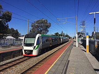
Oats Street railway station is a temporarily-closed Transperth suburban railway station in Western Australia, located in the Perth suburbs of Carlisle and East Victoria Park. The station was served by the Armadale and Thornlie lines prior to its closure in November 2023.

<span class="mw-page-title-main">Thornlie, Western Australia</span> Suburb of Perth, Western Australia

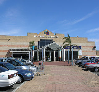
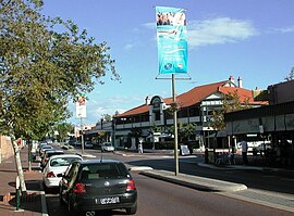
Thornlie is a large residential suburb of Perth, the capital city of Western Australia, located 15 kilometres (9.3 mi) south-east of the city's central business district. It is a part of the City of Gosnells local government area. The Canning River runs through the northern side of the suburb. Since the 1950s the suburb has developed in approximately five stages; north-east Thornlie (1950s–60s), south Thornlie (1970s–80s), Crestwood (1970s), Castle Glen (1980s) and Forest Lakes.

<span class="mw-page-title-main">Burswood, Western Australia</span> Suburb of Perth, Western Australia

Burswood is an inner southeastern suburb of Perth, Western Australia, located immediately across the Swan River from Perth's central business district (CBD). Its local government area is the Town of Victoria Park. Burswood is the location of the State Tennis Centre, Perth Stadium, Belmont Park Racecourse, and the Crown Perth casino and hotel complex.

<span class="mw-page-title-main">Welshpool, Western Australia</span> Suburb of Perth, Western Australia

Welshpool is an inner southeastern suburb of Perth, Western Australia, located mostly within the City of Canning and partially within the Town of Victoria Park.

<span class="mw-page-title-main">Canning Vale, Western Australia</span> Suburb of Perth, Western Australia

Canning Vale is a southern suburb of Perth, 22 km (13.7 mi) from the central business district. Its local government areas are the City of Canning and the City of Gosnells.

<span class="mw-page-title-main">Bentley, Western Australia</span> Suburb of Perth, Western Australia

Bentley is a southern suburb of Perth, the capital city of Western Australia, 8 kilometres (5.0 mi) southeast of Perth's central business district. Its local government areas are the City of Canning and the Town of Victoria Park. Bentley is home to the main campus of Curtin University and Technology Park.

<span class="mw-page-title-main">Cannington, Western Australia</span> Suburb of Perth, Western Australia

Cannington is a southern suburb of Perth, Western Australia. Its local government area is the City of Canning.

East Cannington is a southeastern suburb of Perth, Western Australia. Its local government area is the City of Canning.

<span class="mw-page-title-main">Queens Park, Western Australia</span> Suburb of Perth, Western Australia

Queens Park is a suburb of Perth, Western Australia, located within the City of Canning. Its postcode is 6107.

St James is a suburb shared between the Town of Victoria Park and the City of Canning in the Perth metropolitan area.

<span class="mw-page-title-main">Willetton, Western Australia</span> Suburb of Perth, Western Australia

Willetton is a large southern suburb of Perth, Western Australia. Its local government area is the City of Canning.

<span class="mw-page-title-main">Beckenham, Western Australia</span> Suburb of Perth, Western Australia

Beckenham is a suburb of Perth, Western Australia, located within the City of Gosnells.

<span class="mw-page-title-main">Kenwick, Western Australia</span> Suburb of Perth, Western Australia

Kenwick, Western Australia is a mixed residential, light industrial and semi-rural suburb located in the south-east of Perth, Western Australia, located within the City of Gosnells. A large portion of the suburb is composed of remnant agricultural land organised as smallholdings of several acres, as well as relatively pristine native wetlands, including the Brixton Street Wetlands which are of significant conservation value. It also contains several sites of historical significance relating to its status as one of the early farming communities of the Swan River Colony.

Maddington is a suburb 20 kilometres (12 mi) southeast of the central business district of Perth, the capital of Western Australia, within the City of Gosnells local government area. Maddington is a mixed-use suburb containing major residential, retail and industrial sections as well as some semi-rural areas.

<span class="mw-page-title-main">Gosnells, Western Australia</span> Suburb of Perth, Western Australia

Gosnells is a suburb located within the City of Gosnells. Gosnells is approximately 20 kilometres (12 mi) south-east of the Perth central business district. It contains the Gosnells town centre which includes the Council offices, library and the Gosnells Railway Station.

<span class="mw-page-title-main">Perth (suburb)</span> Suburb of Perth, Western Australia

Perth is a suburb in the Perth metropolitan region, Western Australia that includes both the central business district of the city, and a suburban area spreading north to the northern side of Hyde Park. It does not include the separate suburbs of Northbridge or Highgate. Perth is split between the City of Perth and the City of Vincent local authorities, and was named after the city of the same name in Scotland.

References

  1. Australian Bureau of Statistics (28 June 2022). "East Victoria Park (suburb and locality)". Australian Census 2021 QuickStats. Retrieved 28 June 2022.  OOjs UI icon edit-ltr-progressive.svg
  2. "Edward Millen Home (fmr)". Heritage Council of Western Australia. Retrieved 21 December 2023.
  3. Victoria Park Local Heritage Survey, p. 33
  4. https://www.victoriaparklibrary.wa.gov.au/Profiles/library/Assets/ClientData/Documents/Local_History/History/Geoff-Gallop-Know-Your-Suburb_Victoria-Park-and-East-Victoria-Park.pdf
  5. https://www.victoriaparklibrary.wa.gov.au/Profiles/library/Assets/ClientData/Documents/Local_History/History/Geoff-Gallop-Know-Your-Suburb_Victoria-Park-and-East-Victoria-Park.pdf
  6. https://www.victoriaparklibrary.wa.gov.au/Profiles/library/Assets/ClientData/Documents/Local_History/History/Geoff-Gallop-Know-Your-Suburb_Victoria-Park-and-East-Victoria-Park.pdf
  7. "Route 37". Bus Timetable 90 (PDF). Transperth. 28 August 2023 [effective from 20 November 2023].
  8. Error: timetable not found
  9. "Route 72". Bus Timetable 15 (PDF). Transperth. 25 August 2023 [effective from 20 November 2023].
  10. "Route 75". Bus Timetable 15 (PDF). Transperth. 25 August 2023 [effective from 20 November 2023].
  11. "Route 201". Bus Timetable 14 (PDF). Transperth. 28 August 2023 [effective from 20 November 2023].
  12. "Route 220". Bus Timetable 3 (PDF). Transperth. 5 January 2024 [effective from 28 January 2024].
  13. "Route 282". Bus Timetable 94 (PDF). Transperth. 4 April 2024 [effective from 21 April 2024].
  14. "Route 283". Bus Timetable 94 (PDF). Transperth. 4 April 2024 [effective from 21 April 2024].
  15. "Route 284". Bus Timetable 89 (PDF). Transperth. 25 August 2022 [effective from 20 November 2022].
  16. "Route 285". Bus Timetable 89 (PDF). Transperth. 25 August 2022 [effective from 20 November 2022].
  17. "Route 960". Bus Timetable 210 (PDF). Transperth. 28 August 2023 [effective from 20 November 2023].
  18. "Route 998". CircleRoute Timetable 200 (PDF). Transperth. 29 August 2023 [effective from 20 November 2023].
  19. "Route 999". CircleRoute Timetable 200 (PDF). Transperth. 29 August 2023 [effective from 20 November 2023].
  20. "Route 177". Bus Timetable 9 (PDF). Transperth. 5 September 2023 [effective from 20 November 2023].
  21. "Route 178". Bus Timetable 9 (PDF). Transperth. 5 September 2023 [effective from 20 November 2023].
  22. "Route 179". Bus Timetable 13 (PDF). Transperth. 24 August 2023 [effective from 20 November 2023].
  23. "Route 221". Bus Timetable 3 (PDF). Transperth. 5 January 2024 [effective from 28 January 2024].
  24. "Route 230". Bus Timetable 3 (PDF). Transperth. 5 January 2024 [effective from 28 January 2024].
  25. "Route 907". Bus Timetable 216 (PDF). Transperth. 11 January 2024 [effective from 28 January 2024].
  26. "Route 908". Bus Timetable 217 (PDF). Transperth. 11 January 2024 [effective from 28 January 2024].
  27. "Route 930". Bus Timetable 208 (PDF). Transperth. 11 January 2024 [effective from 28 January 2024].