
The San Luis Valley is a region in south-central Colorado with a small portion overlapping into New Mexico. The valley is approximately 122 miles (196 km) long and 74 miles (119 km) wide, extending from the Continental Divide on the northwest rim into New Mexico on the south. It contains 6 counties and portions of 3 others. It is an extensive high-elevation depositional basin of approximately 8,000 square miles (21,000 km2) with an average elevation of 7,664 feet (2,336 m) above sea level. The valley is a section of the Rio Grande Rift and is drained to the south by the Rio Grande, which rises in the San Juan Mountains to the west of the valley and flows south into New Mexico. The San Luis Valley has a cold desert climate but has substantial water resources from the Rio Grande and groundwater.

The South Platte River is one of the two principal tributaries of the Platte River. Flowing through the U.S. states of Colorado and Nebraska, it is itself a major river of the American Midwest and the American Southwest/Mountain West. Its drainage basin includes much of the eastern flank of the Rocky Mountains in Colorado, much of the populated region known as the Colorado Front Range and Eastern Plains, and a portion of southeastern Wyoming in the vicinity of the city of Cheyenne. It joins the North Platte River in western Nebraska to form the Platte, which then flows across Nebraska to the Missouri. The river serves as the principal source of water for eastern Colorado. In its valley along the foothills in Colorado, it has permitted agriculture in an area of the Colorado Piedmont and Great Plains that is otherwise arid.

Del Norte is a Statutory Town that is the county seat of Rio Grande County, Colorado, United States. The town's name is most commonly pronounced /ˈdɛl nɔɹt/. The town population was 1,458 at the 2020 United States Census.

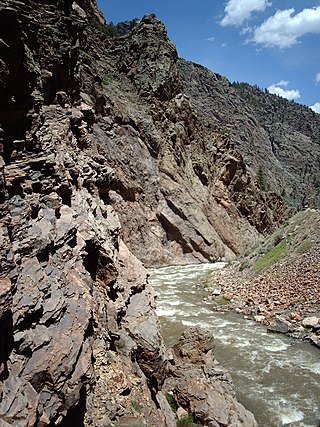
South Fork is a statutory town in Rio Grande County, Colorado, United States. It lies at the confluence of the South Fork and Rio Grande rivers. The population was 510 at the 2020 census.

The Little Colorado River is a tributary of the Colorado River in the U.S. state of Arizona, providing the principal drainage from the Painted Desert region. Together with its major tributary, the Puerco River, it drains an area of about 26,500 square miles (69,000 km2) in eastern Arizona and western New Mexico. Although it stretches almost 340 miles (550 km), only the headwaters and the lowermost reaches flow year-round. Between St. Johns and Cameron, most of the river is a wide, braided wash, only containing water after heavy snowmelt or flash flooding.

Marys River is a 40-mile (64 km) tributary of the Willamette River in the U.S. state of Oregon. From its source at the confluence of its east and west forks near Summit, it flows generally southeast from the Central Oregon Coast Range to Corvallis.

The Feather River is the principal tributary of the Sacramento River, in the Sacramento Valley of Northern California. The river's main stem is about 73 miles (117 km) long. Its length to its most distant headwater tributary is just over 210 miles (340 km). The main stem Feather River begins in Lake Oroville, where its four long tributary forks join—the South Fork, Middle Fork, North Fork, and West Branch Feather Rivers. These and other tributaries drain part of the northern Sierra Nevada, and the extreme southern Cascades, as well as a small portion of the Sacramento Valley. The total drainage basin is about 6,200 square miles (16,000 km2), with approximately 3,604 square miles (9,330 km2) above Lake Oroville.

St. Vrain Creek is a tributary of the South Platte River, approximately 32.2 miles (51.8 km) long, in north central Colorado in the United States. It drains part of the foothills north of Boulder and the Colorado Piedmont area in the vicinity of Longmont.

The Tule River, also called Rio de San Pedro or Rio San Pedro, is a 71.4-mile (114.9 km) river in Tulare County in the U.S. state of California. The river originates in the Sierra Nevada east of Porterville and consists of three forks, North, Middle and South. The North Fork and Middle Fork meet above Springville. The South Fork meets the others at Lake Success. Downstream of Success Dam, the river flows west through Porterville. The river used to empty into Tulare Lake, but its waters have been diverted for irrigation. However, the river does reach Tulare Lake during floods. Tulare Lake is the terminal sink of an endorheic basin that historically also received the Kaweah and Kern Rivers as well as southern distributaries of the Kings.

The Rio Chama, a major tributary river of the Rio Grande, is located in the U.S. states of Colorado and New Mexico. The river is about 130 miles (210 km) long altogether. From its source to El Vado Dam its length is about 50 miles (80 km), from El Vado Dam to Abiquiu Dam is about 51 miles (82 km), and from Abiquiu Dam to its confluence with the Rio Grande is about 34 miles (55 km).
The Cimarron River is a 22.0-mile-long (35.4 km) tributary that joins the Gunnison River in Curecanti National Recreation Area near Cimarron, Colorado. The river's source is the confluence of two forks near Silver Jack Reservoir in the Uncompahgre National Forest.

Catherine Creek is a 32.4-mile-long (52.1 km) creek in northeastern Oregon, United States. A tributary of the Grande Ronde River, it is the second-longest stream in the Grande Ronde Valley. Originating in the foothills of the Wallowa Mountains, it flows generally northwest through Catherine Creek State Park and the city of Union before joining the river.

The Piedra River is a river in the U.S. state of Colorado. It drains parts of Archuleta, Hinsdale, and Mineral counties along a mainstem length of about 40 miles (64 km). The river flows through a series of isolated box canyons, emptying into the San Juan River at Navajo Lake. Its name stems from the Spanish word, piedra, meaning rock.

The Wenaha River is a tributary of the Grande Ronde River, about 22 miles (35 km) long, in the U.S. state of Oregon. The river begins at the confluence of its north and south forks in the Blue Mountains and flows east through the Wenaha–Tucannon Wilderness to meet the larger river at the small settlement of Troy. A designated Wild and Scenic River for its entire length, the stream flows wholly within Wallowa County.

The Middle Fork Eel River is a major tributary of the Eel River of northwestern California in the United States. It drains a rugged and sparsely populated region of the Yolla Bolly Mountains, part of the California Coast Range, in Trinity and Mendocino Counties. Its watershed comprises roughly 745 square miles (1,930 km2) of land, or 20% of the entire Eel River basin. The river provides groundwater recharge and is used for recreation and for industrial, agricultural and municipal water supply by residents.

The Jemez River is a tributary of the Rio Grande in eastern Sandoval County, New Mexico, United States.

Carneros Creek is a westward flowing stream and is the primary source of freshwater flowing into Elkhorn Slough. The Carneros Creek official mainstem is 9.8 miles (15.8 km) long. Its source is in the northern Gabilan Range along Highway 101/156. After it waters transit Elkhorn Slough, the historic mouth of the Salinas River, Carneros Creek empties into Monterey Bay at Moss Landing, California.

Quitaque Creek is an intermittent stream about 40 mi (64 km) long, originating as a shallow draw on the high plains of the Llano Estacado in Floyd County, Texas, and flowing eastward to join the North Pease River in Motley County, Texas.

Costilla Creek is a tributary of the Rio Grande in Colorado and New Mexico.

