Carrizo Hill, Texas

Last updated

Carrizo Hill, Texas
CDP
Dimmit County CarrizoHill.svg
Coordinates: 28°30′12″N99°49′40″W / 28.50333°N 99.82778°W / 28.50333; -99.82778
Country United States
State Texas
County Dimmit
Area
  Total0.5 sq mi (1.3 km2)
  Land0.5 sq mi (1.3 km2)
  Water0.0 sq mi (0.0 km2)
Elevation
[1]
630 ft (190 m)
Population
 (2020)
  Total550
  Density1,100/sq mi (420/km2)
Time zone UTC-6 (Central (CST))
  Summer (DST) UTC-5 (CDT)
FIPS code 48-12982 [2]
GNIS feature ID1852691 [1]

Carrizo Hill is a census-designated place (CDP) in Dimmit County, in the U.S. state of Texas, United States. The population was 550 at the 2020 census.

Contents

History

The town was established in 2000. [3]

Geography

Carrizo Hill is located at 28°30′12″N99°49′40″W / 28.50333°N 99.82778°W / 28.50333; -99.82778 (28.503386, -99.827670). [4]

According to the United States Census Bureau, the CDP has a total area of 0.5 square miles (1.3 km2), all land.

The community is located on US Route 83 and is adjacent to the Dimmit County Airport.

Demographics

Historical population
CensusPop.Note
2000 548
2010 5826.2%
2020 550−5.5%
US Decennial Census [4]
2020 Census [5]

As of the census [2] of 2000, there were 548 people, 154 households, and 135 families residing in the CDP. The population density was 1,131.1 inhabitants per square mile (436.7/km2). There were 185 housing units at an average density of 381.9 per square mile (147.5/km2). The racial makeup of the CDP was 82.30% White, 0.55% African American, 0.73% Native American, 0.36% Asian, 14.23% from other races, and 1.82% from two or more races. Hispanic or Latino of any race were 93.25% of the population.

There were 154 households, out of which 57.1% had children under the age of 18 living with them, 71.4% were married couples living together, 11.0% had a female householder with no husband present, and 11.7% were non-families. 9.7% of all households were made up of individuals, and 5.2% had someone living alone who was 65 years of age or older. The average household size was 3.56 and the average family size was 3.82.

In the CDP, the population was spread out, with 39.4% under the age of 18, 10.2% from 18 to 24, 25.0% from 25 to 44, 20.3% from 45 to 64, and 5.1% who were 65 years of age or older. The median age was 26 years. For every 100 females, there were 106.0 males. For every 100 females age 18 and over, there were 93.0 males.

The median income for a household in the CDP was $14,167, and the median income for a family was $17,273. Males had a median income of $23,750 versus $14,861 for females. The per capita income for the CDP was $22,860. About 50.8% of families and 42.6% of the population were below the poverty line, including 29.1% of those under age 18 and 66.7% of those age 65 or over.

Education

Carrizo Hill is served by the Carrizo Springs Independent School District.

Related Research Articles

<span class="mw-page-title-main">Dimmit County, Texas</span> County in Texas, United States

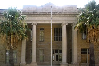
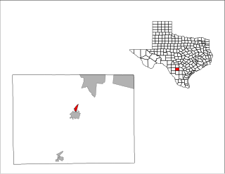
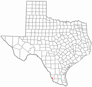
Dimmit County is a county located in the U.S. state of Texas. As of the 2020 census, its population was 8,615. The county seat is Carrizo Springs. The county was founded in 1858 and later organized in 1880. It is named after Philip Dimmitt, a major figure in the Texas Revolution. The spelling of the county name and the individual's name differ because of a spelling error in the bill creating the county name.

<span class="mw-page-title-main">Jeddito, Arizona</span> CDP in Navajo County, Arizona

Jeddito is a census-designated place (CDP) in Navajo County, Arizona, United States. The population was 293 at the 2010 census.

<span class="mw-page-title-main">Humboldt Hill, California</span> Census-designated place in Humboldt County, California, U.S.

Humboldt Hill is a census-designated place (CDP) in Humboldt County, California, United States. Humboldt Hill rises to an elevation of 636 feet (194 m). The population was 3,414 at the 2010 census, up from 3,246 at the 2000 census. The area is in the 95503 zip code and part of unincorporated Eureka.

<span class="mw-page-title-main">Dade City North, Florida</span> CDP in Florida, United States

Dade City North is a census-designated place (CDP) in eastern Pasco County, Florida, United States. The population was 3,319 at the 2000 census.

<span class="mw-page-title-main">Marshfield Hills, Massachusetts</span> Census-designated place in Massachusetts, United States

Marshfield Hills is a census-designated place (CDP) in the town of Marshfield in Plymouth County, Massachusetts, United States. The population was 2,356 at the 2010 census. The historic center of the village has been designated a historic district and listed on the National Register of Historic Places.

<span class="mw-page-title-main">Lyman, Mississippi</span> Census-designated place in Mississippi, United States

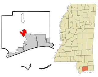
Lyman is a census-designated place (CDP) in Harrison County, Mississippi, United States. It is part of the Gulfport–Biloxi Metropolitan Statistical Area. The population was 1,277 at the 2010 census.

<span class="mw-page-title-main">El Camino Angosto, Texas</span> Census-designated place in Texas, United States

El Camino Angosto is a census-designated place (CDP) in Cameron County, Texas, United States. The population was 186 at the 2020 census. It is part of the Brownsville–Harlingen Metropolitan Statistical Area.

<span class="mw-page-title-main">Lago, Texas</span> Census-designated place in Texas, United States

Lago is a census-designated place (CDP) in Cameron County, Texas, United States. The population was 204 at the 2010 census. It is part of the Brownsville–Harlingen Metropolitan Statistical Area.

<span class="mw-page-title-main">Lasana, Texas</span> Census-designated place in Texas, United States

Lasana is a census-designated place (CDP) in Cameron County, Texas, United States. The population was 84 at the 2010 census, down from 135 at the 2000 census. It is part of the Brownsville–Harlingen Metropolitan Statistical Area.

<span class="mw-page-title-main">Asherton, Texas</span> City in Texas, United States

Asherton is a city in Dimmit County, Texas, United States. The population was 722 at the 2020 census, down from 1,084 at the 2010 census. U.S. Highway 83 passes through Asherton.

Big Wells is a city in Dimmit County, Texas, United States. The population was 483 at the 2020 census, down from 697 at the 2010 census.

<span class="mw-page-title-main">Brundage, Texas</span> Census-designated place in Texas, United States

Brundage is an unincorporated community and census-designated place (CDP) in Dimmit County, Texas, United States. The population was 12 at the 2020 census.

<span class="mw-page-title-main">Carrizo Springs, Texas</span> City in Texas, United States

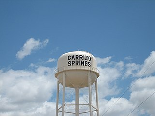
Carrizo Springs is the largest city in and the county seat of Dimmit County, Texas, United States. The population was 4,892 at the 2020 census, down from 5,368 at the 2010 census.

<span class="mw-page-title-main">Catarina, Texas</span> CDP in Texas, United States

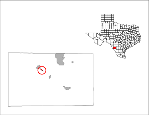
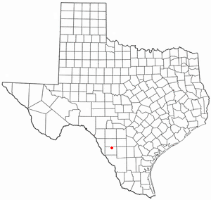
Catarina is a census-designated place (CDP) in Dimmit County, Texas, United States. The population was 70 at the 2020 census. The community has no U.S. Post Office.

<span class="mw-page-title-main">North Pearsall, Texas</span> Census-designated place in Frio County, Texas, United States

North Pearsall is a census-designated place (CDP) in Frio County, Texas, United States. The population was 739 at the 2020 census.

<span class="mw-page-title-main">McQueeney, Texas</span> Census-designated place in Texas, United States

McQueeney is an unincorporated community and census-designated place (CDP) in Guadalupe County, Texas, United States. The population was 2,397 at the 2020 census. It is part of the San Antonio Metropolitan Statistical Area.

<span class="mw-page-title-main">La Victoria, Texas</span> CDP in Texas, United States

La Victoria is a census-designated place (CDP) in Starr County, Texas, United States. La Victoria underwent some changes prior to the 2010 census. It gained area, had portions taken to form new CDPs, and lost additional area. Only a small part of 2010 La Victoria CDP was within the 2000 La Victoria CDP. The population was only 171 at the 2010 census, a decline from the figure of 1,683 tabulated at the 2000 census.

<span class="mw-page-title-main">Knippa, Texas</span> Census-designated place in Texas, United States

Knippa is a census-designated place (CDP) in Uvalde County, Texas, United States. The population was 606 at the 2020 census.

<span class="mw-page-title-main">La Presa, Texas</span> CDP in Texas, United States

La Presa is a census-designated place (CDP) in Webb County, Texas, United States. The population was 241 at the 2020 census.

<span class="mw-page-title-main">Falcon Mesa, Texas</span> CDP in Texas, United States

Falcon Mesa is a census-designated place (CDP) in Zapata County, Texas, United States. The population was 523 at the 2020 census.

References

  1. 1 2 U.S. Geological Survey Geographic Names Information System: Carrizo Hill, Texas
  2. 1 2 "U.S. Census website". United States Census Bureau . Retrieved January 31, 2008.
  3. "Carrizo Hill, Texas". Texas State Historical Association. Retrieved February 6, 2012.
  4. 1 2 "US Gazetteer files: 2010, 2000, and 1990". United States Census Bureau. February 12, 2011. Retrieved April 23, 2011.
  5. "Census Bureau profile: Carrizo Hill, Texas". United States Census Bureau. May 2023. Retrieved June 9, 2024.