Cass, West Virginia

Last updated

Cass
Cass WV - Main Street.jpg
Main Street in Cass
USA West Virginia location map.svg
Red pog.svg
Cass
Location within the state of West Virginia
Usa edcp location map.svg
Red pog.svg
Cass
Cass (the United States)
Coordinates: 38°23′48″N79°54′53″W / 38.39667°N 79.91472°W / 38.39667; -79.91472
Country United States
State West Virginia
County Pocahontas
Area
[1]
  Total0.790 sq mi (2.05 km2)
  Land0.790 sq mi (2.05 km2)
  Water0 sq mi (0 km2)
Population
 (2020) [2]
  Total38
  Density48/sq mi (19/km2)
Time zone UTC-5 (Eastern (EST))
  Summer (DST) UTC-4 (EDT)

Cass is a census-designated place (CDP) and unincorporated community on the Greenbrier River in Pocahontas County, West Virginia, United States. The population was 38 at the 2020 census. [3] The community, founded in 1901, was named for Joseph Kerr Cass, vice president and cofounder of the West Virginia Pulp and Paper Company.

Contents

History

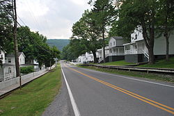
Cass was created in 1901 as a company town for those who worked for West Virginia Pulp and Paper Company, logging the nearby Cheat Mountain. The cut logs were brought by rail to the town, where they were processed for use by paper and hardwood-flooring companies throughout the United States. Cass's skilled laborers, who worked in the mill or the locomotive repair shop, lived with their families in 52 white-fenced houses, built in orderly rows on a hill south of the general store. [4]

In 1960 the mill closed. In 1963, the state bought the logging railroad and converted it into a tourist attraction, carrying passengers into the vast Monongahela National Forest. In the late 1970s, the state bought most of the town and its buildings for the new Cass Scenic Railroad State Park. In 1982 the mill burned down. [4]

The Cass Historic District was listed on the National Register of Historic Places in 1980. [5]

Current status

The community has a general store, a restaurant, a history museum, and 20 houses refurbished for tourist lodgings. Cass Scenic Railroad State Park runs from the town to the half way point called Whittaker Station. Here a restored loggers' camp has been created on the mountain. Then the railroad continues up the Mountain to Bald Knob (the third highest peak in West Virginia). On Fridays the trains make runs to the ghost town of Spruce, West Virginia (currently[ when? ] not in service). A small number of privately-owned homes remain in the area of the community, while the majority of land and homes in Cass is owned by the State of West Virginia.

Cass is the northern terminus of the Greenbrier River Trail.

Cass Cave, located in Cass, contains the highest subterranean waterfall in West Virginia and Virginia, Lacy Suicide Falls. [6]

Demographics

Historical population
CensusPop.Note
2010 52
2020 38−26.9%
U.S. Decennial Census [8]

Related Research Articles

<span class="mw-page-title-main">Lincoln, New Hampshire</span> Town in New Hampshire, United States

Lincoln is a town in Grafton County, New Hampshire, United States. It is the second-largest town by area in New Hampshire. The population was 1,631 at the 2020 census. The town is home to the New Hampshire Highland Games and to a portion of Franconia Notch State Park. Set in the White Mountains, large portions of the town are within the White Mountain National Forest. The Appalachian Trail crosses the western and northeastern parts of the town. Lincoln is the location of Loon Mountain Ski Resort and associated recreation-centered development.

<span class="mw-page-title-main">Pocahontas County, West Virginia</span> County in West Virginia, United States

Pocahontas County is a county located in the eastern part of the U.S. state of West Virginia. As of the 2020 census, the population was 7,869. Its county seat is Marlinton. The county was established in 1821. It is named after the daughter of the Powhatan chief of the Native Americans in the United States who came from Jamestown, Virginia. She married an English settler, and their children became ancestors of many of the First Families of Virginia.

<span class="mw-page-title-main">North Conway, New Hampshire</span> Census-designated place in New Hampshire, United States

North Conway is a census-designated place (CDP) and village in eastern Carroll County, New Hampshire, United States. The population was 2,116 at the 2020 census. A year-round resort area, North Conway is the second-largest village within the town of Conway, after the village of Conway proper. North Conway maintains its own fire station, post office and public library, sharing its other services with Conway. The White Mountain National Forest is to the west and north. The area is home to Cathedral Ledge, Echo Lake State Park, and Cranmore Mountain Resort. North Conway is known for its large number of outlet shops.

<span class="mw-page-title-main">Canton, North Carolina</span> Town in North Carolina, United States

Canton is the second largest town in Haywood County, North Carolina, United States. It is located about 17 miles (27 km) west of Asheville and is part of that city's metropolitan area. The town is named after the city of Canton, Ohio. The population was 4,227 at the 2010 census.

<span class="mw-page-title-main">Wilder, Vermont</span> Census-designated place in Vermont, United States

Wilder is an unincorporated village and census-designated place (CDP) within the town of Hartford in Windsor County, Vermont, United States. It is the location of the Wilder Dam on the Connecticut River. The population of the CDP was 1,690 at the 2010 census. The village center is an early example of a planned mill community, and was listed on the National Register of Historic Places as the Wilder Village Historic District in 1999.

<span class="mw-page-title-main">Ronceverte, West Virginia</span> City in West Virginia, United States

Ronceverte is a city in Greenbrier County, West Virginia, United States, on the Greenbrier River. The population was 1,572 at the 2020 census.

<span class="mw-page-title-main">Shay locomotive</span> Geared steam locomotive

The Shay locomotive is a geared steam locomotive that originated and was primarily used in North America. The locomotives were built to the patents of Ephraim Shay, who has been credited with the popularization of the concept of a geared steam locomotive. Although the design of Ephraim Shay's early locomotives differed from later ones, there is a clear line of development that joins all Shays. Shay locomotives were especially suited to logging, mining and industrial operations and could operate successfully on steep or poor quality track.

<span class="mw-page-title-main">Greenbrier River</span> River in West Virginia, United States

The Greenbrier River is a tributary of the New River, 162 miles (261 km) long, in southeastern West Virginia, in the United States. Via the New, Kanawha and Ohio rivers, it is part of the watershed of the Mississippi River, draining an area of 1,656 square miles (4,290 km2). It is one of the longest rivers in West Virginia.

<span class="mw-page-title-main">Cass Scenic Railroad State Park</span> State Park in Cass and Pocahontas counties, West Virginia

Cass Scenic Railroad State Park is a state park and heritage railroad located in Cass, Pocahontas County, West Virginia.

Burlington is a census-designated place (CDP) in Mineral County, West Virginia, United States, located along U.S. Route 50 where it crosses Pattersons Creek. As of the 2020 census, its population was 131. It is part of the Cumberland, MD-WV Metropolitan Statistical Area. The ZIP code for Burlington is 26710.

<span class="mw-page-title-main">Cheat Mountain</span>

Cheat Mountain is an exceptionally high and rugged ridge situated in the Allegheny Mountains of eastern West Virginia, USA. It is about 50 miles (80 km) long and more than five miles (8 km) wide at its widest. Its highest point is at its southernmost end at Thorny Flat, which has an elevation of 4,848 feet (1,478 m). Several other knobs rise above 4,000 feet (1,200 m) along its length.

<span class="mw-page-title-main">Prospect, Oregon</span> Unincorporated community in the state of Oregon, United States

Prospect is an unincorporated community and census-designated place (CDP) in Jackson County, in the U.S. state of Oregon. It lies along Oregon Route 62 on the Rogue River, in the Rogue River – Siskiyou National Forest. As of the 2010 census it had a population of 455.

<span class="mw-page-title-main">Meadow River Lumber Company</span>

The Meadow River Lumber Company, which operated in Rainelle, West Virginia from 1906 to 1975, was the largest hardwood sawmill in the world. It had three 9 feet (2.7 m) bandsaws under one roof. In 1928, during peak production, its 500 employees produced 31 million board feet of lumber, cutting 3,000 acres (12 km2) of virgin timber a year.

<span class="mw-page-title-main">Durbin and Greenbrier Valley Railroad</span>

The Durbin and Greenbrier Valley Railroad is a heritage and freight railroad in the U.S. states of Virginia and West Virginia. It operates the West Virginia State Rail Authority-owned Durbin Railroad and West Virginia Central Railroad, as well as the Shenandoah Valley Railroad in Virginia.

Glen Jean is a census-designated place (CDP) in Fayette County, West Virginia, United States, near Oak Hill. As of the 2010 census, its population is 210.

<span class="mw-page-title-main">South Windham, Maine</span> Census-designated place in Maine, United States

South Windham is a census-designated place (CDP) in the town of Windham in Cumberland County, Maine, United States. The population of the CDP was 1,374 at the 2010 census. Prior to 2010, South Windham was part of the Little Falls-South Windham census-designated place.

<span class="mw-page-title-main">W. E. Blackhurst</span> American writer

Warren Elmer "Tweard" Blackhurst (1904–1970) was an author and a lifelong resident of the Cass community who centered on the culture of eastern West Virginia where the higher elevations supported northern pine forests. "Riders of the Flood" which is arguably the most well-known of Blackhurst's books, for it centers on the world of the late 19th to early 20th-century logging industry in eastern West Virginia through the Greenbrier River and its tributaries.

The Greenbrier, Cheat and Elk Railroad (GC&E) was a logging railroad in West Virginia operating in the early 20th century. Its main line ran from Bergoo to Cheat Junction, where it connected with the Western Maryland Railway (WM).

<span class="mw-page-title-main">Bartow, West Virginia</span> Census-designated place in West Virginia, United States

Bartow is a census-designated place (CDP) in Pocahontas County, West Virginia, United States. The population was 111 at the 2010 census.

Spruce is a ghost town in Pocahontas County, West Virginia, United States. Spruce is 9.5 miles (15.3 km) southwest of Durbin.

References

  1. "US Gazetteer files: 2010, 2000, and 1990". United States Census Bureau. February 12, 2011. Retrieved April 23, 2011.
  2. "U.S. Census website". United States Census Bureau . Retrieved May 14, 2011.
  3. "Cass CDP, West Virginia - Census Bureau Profile". data.census.gov. Retrieved May 7, 2022.
  4. 1 2 Christine Dell'Amore (September 9, 2009). "Tracking a Lumber Town's History". The Washington Post.
  5. "National Register Information System". National Register of Historic Places . National Park Service. July 9, 2010.
  6. Kevin Adams (June 1, 2002). Waterfalls of Virginia and West Virginia: A Hiking and Photography Guide. Menasha Ridge Press. pp. 32–. ISBN   978-0-89732-414-4.
  7. "Appalachia". Travel Channel. Retrieved April 23, 2018.
  8. Bureau, US Census. "Decennial Census of Population and Housing". Census.gov. Retrieved May 7, 2022.