Castle Hayne, North Carolina

Last updated

Castle Hayne, North Carolina
CDP
Castle Hayne 03.jpg
New Hanover County North Carolina incorporated and unincorporated areas Castle Hayne highlighted.svg
Location in New Hanover County and the state of North Carolina.
Coordinates: 34°21′30″N77°54′41″W / 34.35833°N 77.91139°W / 34.35833; -77.91139
Country United States
State North Carolina
County New Hanover
Area
[1]
  Total5.15 sq mi (13.35 km2)
  Land4.76 sq mi (12.34 km2)
  Water0.39 sq mi (1.01 km2)
Elevation
[2]
10 ft (3 m)
Population
 (2020)
  Total1,243
  Density260.92/sq mi (100.73/km2)
Time zone UTC-5 (Eastern (EST))
  Summer (DST) UTC-4 (EDT)
ZIP code
28429
Area codes 910, 472
FIPS code 37-10880 [3]
GNIS feature ID2402752 [2]

Castle Hayne is a census-designated place (CDP) in New Hanover County, North Carolina, United States. The population was 1,202 at the 2010 census, up from 1,116 in 2000. It is part of the Wilmington Metropolitan Statistical Area.

Contents

The forest provided the region's major industries through the 18th and most of the 19th century: naval stores and lumber fueled the economy both before and after the American Revolution. During the Revolutionary War, the British maintained a garrison at Fort Johnson near Wilmington. After suffering crippling losses at Guilford Court House, the British withdrew all forces back to Fort Johnson and abandoned plans to occupy North Carolina. This prompted the British to attack Yorktown, Virginia instead, which brought an end to the war.

History

The town took its name from the large house of Captain Roger Haynes. [4]

Leading up to the 2011 election, there was a large movement among the residents to incorporate Castle Hayne [5] [6] to become the "Town of Castle Hayne". Nearby Wilmington had previously forced an annexation of Monkey Junction in 2010 [7] and proposed a forced annexation of Ogden, [8] both of which had resulted in numerous lawsuits and appeals.

The incorporation referendum failed in November 2011. [9]

Geography

According to the United States Census Bureau, the CDP has a total area of 2.3 square miles (6.0 km2), of which 2.2 square miles (5.7 km2) is land and 0.04 square miles (0.10 km2) (1.32%) is water.

Demographics

Central junction of Castle Hayne, North Carolina Castle Hayne 01.jpg
Central junction of Castle Hayne, North Carolina
Historical population
CensusPop.Note
2000 1,116
2010 1,2027.7%
2020 1,2433.4%
U.S. Decennial Census [10]

2020 census

Castle Hayne racial composition [11]
RaceNumberPercentage
White (non-Hispanic)95076.43%
Black or African American (non-Hispanic)12910.38%
Native American 120.97%
Asian 40.32%
Pacific Islander 10.08%
Other/Mixed 524.18%
Hispanic or Latino 957.64%

As of the 2020 United States census, there were 1,243 people, 559 households, and 267 families residing in the CDP.

2000 census

At the 2000 census, [3] there were 1,116 people, 437 households and 312 families residing in the CDP. The population density was 495.9 inhabitants per square mile (191.5/km2). There were 471 housing units at an average density of 209.3 per square mile (80.8/km2). The racial makeup of the CDP was 81.54% White, 14.78% African American, 0.99% Native American, 0.27% Asian, 0.99% from other races, and 1.43% from two or more races. Hispanic or Latino of any race were 1.79% of the population. 17.4% were of Irish, 14.8% English, 7.3 United States or American, 5.7% Scots-Irish, 5.6% Subsaharan African, 5.1% German and 5.0% French ancestry according to Census 2000.

There were 437 households, of which 34.1% had children under the age of 18 living with them, 51.0% were married couples living together, 15.6% had a female householder with no husband present, and 28.6% were non-families. 22.0% of all households were made up of individuals, and 6.4% had someone living alone who was 65 years of age or older. The average household size was 2.55 and the average family size was 2.96.

25.9% of residents were under the age of 18, 8.8% from 18 to 24, 30.1% from 25 to 44, 24.7% from 45 to 64, and 10.5% who were 65 years of age or older. The median age was 36 years. For every 100 females, there were 96.8 males. For every 100 females age 18 and over, there were 93.2 males.

The median household income was $34,531, and the median family income was $42,417. Males had a median income of $38,375 versus $25,040 for females. The per capita income for the CDP was $17,172. About 4.6% of families and 6.2% of the population were below the poverty line, including 7.9% of those under age 18 and 3.8% of those age 65 or over.

Sign for Castle Hayne Rd (US 117) in the center of Castle Hayne Castle Hayne Road Sign.jpg
Sign for Castle Hayne Rd (US 117) in the center of Castle Hayne

Major highways

Related Research Articles

<span class="mw-page-title-main">Greenville, Delaware</span> CDP in Delaware, United States

Greenville is a bedroom community in New Castle County, Delaware, United States, and a suburb of Wilmington. The population was 2,326 at the 2010 census. For statistical purposes, the United States Census Bureau has defined Greenville as a census-designated place (CDP). The community is also home to the private residence of Joe Biden, the 46th and current president of the United States, and many Du Pont family descendants.

<span class="mw-page-title-main">Wilmington Manor, Delaware</span> CDP in Delaware, United States

Wilmington Manor is a census-designated place (CDP) in north-eastern New Castle County, Delaware, United States. The population was 7,889 at the 2010 census.

<span class="mw-page-title-main">Pinewood, Florida</span> Census-designated place in Florida

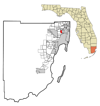
Pinewood is an unincorporated community and census-designated place (CDP) in Miami-Dade County, Florida, United States. It is part of the Miami metropolitan area of South Florida. The population was 17,246 at the 2020 census.

<span class="mw-page-title-main">Littlefield Township, Michigan</span> Civil township in Michigan, United States

Littlefield Township is a civil township of Emmet County in the U.S. state of Michigan. The population was 2,978 at the 2010 census.

<span class="mw-page-title-main">Pemberton Heights, New Jersey</span> Populated place in Burlington County, New Jersey, US

Pemberton Heights is an unincorporated community and census-designated place (CDP) located within Pemberton Township, in Burlington County, in the U.S. state of New Jersey. As of the 2010 United States Census, the CDP's population was 2,423.

Horseheads North is a census-designated place (CDP) in Chemung County, New York, United States. It is part of the Elmira Metropolitan Statistical Area. As of the 2010 census, the population of the CDP was 2,843.

<span class="mw-page-title-main">Harbor Isle, New York</span> Hamlet and census-designated place in New York, United States

Harbor Isle is a hamlet and census-designated place (CDP) in the Town of Hempstead in Nassau County, New York, United States. The population was 1,301 at the 2010 census.

<span class="mw-page-title-main">Moriches, New York</span> Hamlet and census-designated place in New York, United States

Moriches is a hamlet and census-designated place (CDP) in the Suffolk County town of Brookhaven, New York, United States. The population was 2,838 at the 2010 census.

<span class="mw-page-title-main">St. Stephens, North Carolina</span> Census-designated place in North Carolina, United States

St. Stephens is a census-designated place (CDP) in Catawba County, North Carolina, United States. The population was 8,759 at the 2010 census, down from 9,439 in 2000. It is part of the Hickory–Lenoir–Morganton Metropolitan Statistical Area.

<span class="mw-page-title-main">Kirkland, North Carolina</span> CDP in North Carolina, United States

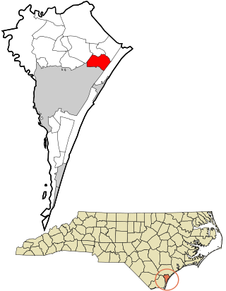
Kirkland, more commonly known as Porter's Neck, was a census-designated place (CDP) in New Hanover County, North Carolina, United States. Redesignated as Porters Neck CDP for the 2010 census, the population was 6,204. It is part of the Wilmington Metropolitan Statistical Area.

<span class="mw-page-title-main">Masonboro, North Carolina</span> Former census-designated place in North Carolina, United States

Masonboro was a census-designated place (CDP) in New Hanover County, North Carolina. The last census count in 2000 was 11,812. Masonboro was located southeast of Wilmington near the Atlantic coast.

<span class="mw-page-title-main">Myrtle Grove, North Carolina</span> CDP in North Carolina, United States

Myrtle Grove is a census-designated place (CDP) in New Hanover County, North Carolina, United States. The population was 8,875 at the 2010 census. It is part of the Wilmington Metropolitan Statistical Area.

<span class="mw-page-title-main">Ogden, North Carolina</span> CDP in North Carolina, United States

Ogden is a census-designated place (CDP) in New Hanover County, North Carolina, United States. It is both a suburb of the city of Wilmington and part of the Wilmington Metropolitan Statistical Area. The population was 6,766 at the 2010 census, up from 5,481 in 2000.

<span class="mw-page-title-main">Seagate, North Carolina</span> Former census-designated place in North Carolina, United States

Seagate was a census-designated place (CDP) in New Hanover County, North Carolina, United States. The last census count in 2000 was 4,590. It was annexed by the city of Wilmington in 1998.

<span class="mw-page-title-main">Rutherford, Pennsylvania</span> Census-designated place in Pennsylvania, United States

Rutherford is a census-designated place (CDP) in Swatara Township, Dauphin County, Pennsylvania, United States. The area is also known as Rutherford Heights. The population was 4,303 at the 2010 census, an increase over the figure of 3,859 tabulated in 2000. It is part of the Harrisburg–Carlisle Metropolitan Statistical Area.

<span class="mw-page-title-main">New Castle Northwest, Pennsylvania</span> Census-designated place in Pennsylvania, United States

New Castle Northwest is an unincorporated area and census-designated place (CDP) in Lawrence County, Pennsylvania, United States. The population was 1,413 at the 2010 census.

Colonial Heights is a census-designated place (CDP) in Sullivan County, Tennessee, United States. It is located within the city of Kingsport.

<span class="mw-page-title-main">East Renton Highlands, Washington</span> Census-designated place in Washington, United States

East Renton Highlands is a census-designated place (CDP) in King County, Washington, United States, located between Issaquah and Renton. The population was 11,937 at the 2020 census.

<span class="mw-page-title-main">Bohners Lake, Wisconsin</span> CDP in Wisconsin, United States

Bohners Lake is a census-designated place (CDP) in Racine County, Wisconsin, United States. Its first syllable is pronounced as in "bone". The population of the CDP was 2,374 at the 2020 census. It is politically part of the Town of Burlington, together with Browns Lake, Wisconsin. There has been discussion of incorporating Bohners Lake as a village to prevent annexation by the City of Burlington. It was named for Antony Bohner, a French immigrant who established a resort on the lake of the same name.

<span class="mw-page-title-main">Windsor, Wisconsin</span> Village in Wisconsin, United States

Windsor is a village and former town in Dane County, Wisconsin. The population was 8,754 at the time of the 2020 census. The communities of Lake Windsor, Morrisonville, and Token Creek are located within the village. Windsor voted to incorporate as a village on November 3, 2015; prior to its incorporation, it was a town, and a portion of the town was a census-designated place. Windsor is a part of the Census Bureau's Madison metropolitan statistical area.

References

  1. "ArcGIS REST Services Directory". United States Census Bureau. Retrieved September 20, 2022.
  2. 1 2 U.S. Geological Survey Geographic Names Information System: Castle Hayne, North Carolina
  3. 1 2 "U.S. Census website". United States Census Bureau . Retrieved January 31, 2008.
  4. Proffitt, Martie (April 17, 1983). "Local history offers tasty tidbits". Star-News. pp. 8C. Retrieved November 1, 2015.
  5. "Push persists to incorporate Castle Hayne". starnewsonline.com/. Wilmington Star News. July 26, 2010.
  6. Cliff Pyron (November 3, 2011). "Castle Hayne residents discuss incorporation". wwaytv3.com/. WWAY-TV. Archived from the original on September 3, 2014. Retrieved August 27, 2014.
  7. "Despite appeal, Wilmington moves forward with MJ annexation plans". wect.com/. WECT. August 1, 2010.
  8. "Wilmington explains annexation plan to Ogden homeowners". wect.com/. WECT. August 13, 2010.
  9. "Castle Hayne voters say no to incorporation". twcnews.com/. Time Warner Cable News. November 9, 2011. Retrieved August 27, 2014.
  10. "Census of Population and Housing". Census.gov. Retrieved June 4, 2016.
  11. "Explore Census Data". data.census.gov. Retrieved December 24, 2021.