Lancaster Castle is a medieval castle and former prison in Lancaster in the English county of Lancashire. Its early history is unclear, but it may have been founded in the 11th century on the site of a Roman fort overlooking a crossing of the River Lune. In 1164 the Honour of Lancaster, including the castle, came under royal control. In 1322 and 1389 the Scots invaded England, progressing as far as Lancaster and damaging the castle. It was not to see military action again until the English Civil War. The castle was first used as a prison in 1196 although this aspect became more important during the English Civil War. The castle buildings are owned by the British sovereign as Duke of Lancaster; part of the structure is used to host sittings of the Crown Court.
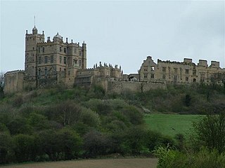
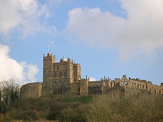
Bolsover Castle is in the town of Bolsover, in the north-east of the English county of Derbyshire. Built in the early 17th century, the present castle lies on the earthworks and ruins of the 12th-century medieval castle; the first structure of the present castle was built between 1612 and 1617 by Sir Charles Cavendish. The site is now in the care of the English Heritage charity, as both a Grade I listed building and a Scheduled Ancient Monument.

Castleton is a village in the High Peak district of Derbyshire, England, at the western end of the Hope Valley on the Peakshole Water, a tributary of the River Noe, between the Dark Peak to the north and the White Peak to the south. The population was 642 at the 2011 Census.

The history of Derbyshire can be traced back to human settlement since the last Ice Age, over 10,000 years ago. The county of Derbyshire in England dates back to the 11th century.

York has, since Roman times, been defended by walls of one form or another. To this day, substantial portions of the walls remain, and York has more miles of intact wall than any other city in England. They are known variously as York City Walls, the Bar Walls and the Roman walls. The walls are generally 13 feet (4m) high and 6 feet (1.8m) wide. They are the longest town walls in England.

The Limestone Way is a waymarked long-distance footpath in Derbyshire, England. It runs for 46 miles (74 km) through the White Peak of the Peak District National Park, from Castleton south to Rocester over the county boundary into Staffordshire. The trail is named for the limestone scenery along its route. It was devised by Brian Spencer of Matlock Rotary Club and developed and opened in 1986 by the West Derbyshire District Council. It originally ran to Matlock, but was extended to its current, longer route in 1992 to join up with the Staffordshire Way.

Codnor is a village and civil parish in the Amber Valley district of Derbyshire, England. Codnor is a former mining village and had a population of 3,766 taken at the 2011 Census. It is approximately 12 miles from Derby and 14 miles from Nottingham. Codnor forms a built up area with nearby Ripley.

Cooling Castle is a 14th-century quadrangular castle in the village of Cooling, Kent on the Hoo Peninsula about 6 miles (9.7 km) north of Rochester. It was built in the 1380s by the Cobham family, the local lords of the manor, to guard the area against French raids into the Thames Estuary. The castle has an unusual layout, comprising two walled wards of unequal size next to each other, surrounded by moats and ditches. It was the earliest English castle designed for the use of gunpowder weapons by its defenders.
Buckton Castle was a medieval enclosure castle near Carrbrook in Stalybridge, Greater Manchester, England. It was surrounded by a 2.8-metre-wide (9 ft) stone curtain wall and a ditch 10 metres (33 ft) wide by 6 metres (20 ft) deep. Buckton is one of the earliest stone castles in North West England and only survives as buried remains overgrown with heather and peat. It was most likely built and demolished in the 12th century. The earliest surviving record of the site dates from 1360, by which time it was lying derelict. The few finds retrieved during archaeological investigations indicate that Buckton Castle may not have been completed.

Rougemont Gardens is an ornamental open space adjacent to Rougemont Castle in the city of Exeter, Devon, England. It is Grade II listed in the National Register of Historic Parks and Gardens. Originally part of the defences of the castle, it was converted into a garden in the late 18th century, and purchased by the city council in 1912.

Pilsbury Castle was a Norman castle in Derbyshire near the present-day village of Pilsbury, overlooking the River Dove.
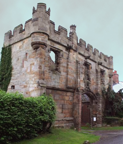
Mackworth Castle was a 14th- or 15th-century structure located in Derbyshire, at the upper end of Mackworth village near Derby. The home for several centuries of the Mackworth family, it was at some point reduced to the ruins of a gatehouse suggestive of a grand castle. A survey from 1911 suggested that though the gatehouse resembled a castle, the rest of the structure may have been more modest. The remains are part of a designated Scheduled Ancient Monument.

Peveril Castle is a ruined 11th-century castle overlooking the village of Castleton in the English county of Derbyshire. It was the main settlement of the feudal barony of William Peverel, known as the Honour of Peverel, and was founded some time between the Norman Conquest of 1066 and its first recorded mention in the Domesday Survey of 1086, by Peverel, who held lands in Nottinghamshire and Derbyshire as a tenant-in-chief of the king. The town became the economic centre of the barony. The castle has views across the Hope Valley and Cave Dale.
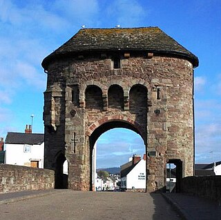
The Monmouth town walls and defences comprise the defensive system of town walls and gates built in Monmouth, Wales between 1297 and the early part of the following century. Wye Bridge Gate, East Gate, Monk's Gate, and Monnow Bridge Gate were access points to the town. West Gate, across Monnow Street, also provided access. Only the Monnow Bridge Gatehouse survives intact, albeit in a substantially modified version from the original.
This is a list of scheduled monuments in the district of Amber Valley in the English county of Derbyshire.
This is a list of scheduled monuments in the district of Bolsover in the English county of Derbyshire.
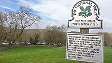
This is a list of scheduled monuments in the district of High Peak in the English county of Derbyshire.
This is a list of scheduled monuments in the district of South Derbyshire in the English county of Derbyshire.
Castleton is a civil parish in the High Peak district of Derbyshire, England. The parish contains 25 listed buildings that are recorded in the National Heritage List for England. Of these, one is listed at Grade I, the highest of the three grades, one is at Grade II*, the middle grade, and the others are at Grade II, the lowest grade. The parish contains the village of Castleton and the surrounding countryside and moorland. The most important building in the parish is the ruined Peveril Castle, which is listed at Grade I. The other listed buildings include houses, cottages and associated structures, farmhouses and farm buildings, a church and a sundial in the churchyard, a hotel and a public house, a former watermill, three mileposts, a school, a war memorial, and a telephone kiosk.
Brandon Camp is an archaeological site, about 1 mile south of Leintwardine, in Herefordshire. England. It is a hillfort of the Iron Age, which later became a Roman fort. The site is a scheduled monument.